
Stour Valley Walk
Encyclopedia
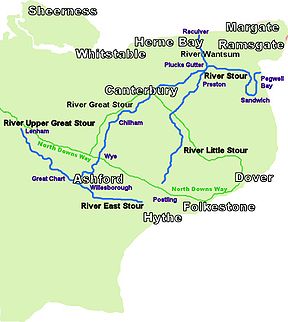
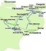
River Stour, Kent
The River Stour is the river in Kent, England that flows into the English Channel at Pegwell Bay. Above Plucks Gutter, where the Little Stour joins it, the river is normally known as the Great Stour. The upper section of the river, above its confluence with the East Stour at Ashford is sometimes...
, through the Low Weald
Weald
The Weald is the name given to an area in South East England situated between the parallel chalk escarpments of the North and the South Downs. It should be regarded as three separate parts: the sandstone "High Weald" in the centre; the clay "Low Weald" periphery; and the Greensand Ridge which...
and Kent Downs
Downland
A downland is an area of open chalk hills. This term is especially used to describe the chalk countryside in southern England. Areas of downland are often referred to as Downs....
, from its source at Lenham
Lenham
Lenham is a market village in Kent situated on the southern edge of the North Downs, halfway between Maidstone and Ashford. The picturesque square in the village has two public houses , a couple of restaurants, and a tea-room....
to its estuary at Pegwell Bay
Pegwell Bay
Pegwell Bay is a shallow inlet in the English Channel coast at the estuary of the River Stour between Ramsgate and Sandwich in Kent. Situated in the bay is a large nature reserve, known for its migrating waders and wildfowl, with a complete series of seashore habitats including extensive mudflats...
.
Kent
Kent is a county in southeast England, and is one of the home counties. It borders East Sussex, Surrey and Greater London and has a defined boundary with Essex in the middle of the Thames Estuary. The ceremonial county boundaries of Kent include the shire county of Kent and the unitary borough of...
's finest landscapes, most important nature sites and most historic, un-spoilt villages. The walk is signed with the logo of a Heron
Grey Heron
The Grey Heron , is a wading bird of the heron family Ardeidae, native throughout temperate Europe and Asia and also parts of Africa. It is resident in the milder south and west, but many birds retreat in winter from the ice in colder regions...
, occasionally seen in the area.
The 51.5 mile (82.4 km) route is of interest for its landscape and history, and for its archaeological, historical and architectural features. Part of the Pilgrims' Way
Pilgrims' Way
The Pilgrims' Way is the historic route supposed to have been taken by pilgrims from Winchester in Hampshire, England, to the shrine of Thomas Becket at Canterbury in Kent...
followed the river valley from Wye to Canterbury
Canterbury
Canterbury is a historic English cathedral city, which lies at the heart of the City of Canterbury, a district of Kent in South East England. It lies on the River Stour....
after the North Downs
North Downs
The North Downs are a ridge of chalk hills in south east England that stretch from Farnham in Surrey to the White Cliffs of Dover in Kent. The North Downs lie within two Areas of Outstanding Natural Beauty , the Surrey Hills and the Kent Downs...
.
The walk passes through a varied landscape of downland
Downland
A downland is an area of open chalk hills. This term is especially used to describe the chalk countryside in southern England. Areas of downland are often referred to as Downs....
, woodland
Woodland
Ecologically, a woodland is a low-density forest forming open habitats with plenty of sunlight and limited shade. Woodlands may support an understory of shrubs and herbaceous plants including grasses. Woodland may form a transition to shrubland under drier conditions or during early stages of...
, orchards, hop
Hop (plant)
Humulus, Hop, is a small genus of flowering plants native to temperate regions of the Northern Hemisphere. The female flowers of H. lupulus are known as hops, and are used as a culinary flavoring and stabilizer, especially in the brewing of beer...
gardens and farm
Farm
A farm is an area of land, or, for aquaculture, lake, river or sea, including various structures, devoted primarily to the practice of producing and managing food , fibres and, increasingly, fuel. It is the basic production facility in food production. Farms may be owned and operated by a single...
land; lakes, dykes and marshland; unspoilt villages and hamlets
Hamlet (place)
A hamlet is usually a rural settlement which is too small to be considered a village, though sometimes the word is used for a different sort of community. Historically, when a hamlet became large enough to justify building a church, it was then classified as a village...
; and historic towns.
It is possible to reach the walk from Maidstone
Maidstone
Maidstone is the county town of Kent, England, south-east of London. The River Medway runs through the centre of the town linking Maidstone to Rochester and the Thames Estuary. Historically, the river was a source and route for much of the town's trade. Maidstone was the centre of the agricultural...
via the 12 kilometer long Len Valley Walk (booklet available from Maidstone Council).
The route
- a) LenhamLenhamLenham is a market village in Kent situated on the southern edge of the North Downs, halfway between Maidstone and Ashford. The picturesque square in the village has two public houses , a couple of restaurants, and a tea-room....
to Little ChartLittle ChartLittle Chart is a civil parish and small village to the north-east of Ashford in Kent, South East England. The parish has an area of , and a population of 239. Within the parish boundaries are two hamlets: Little Chart Forstal ; and Rooting Street...
6 ¼ miles (10 km) - b) Little Chart to AshfordAshford, KentAshford is a town in the borough of Ashford in Kent, England. In 2005 it was voted the fourth best place to live in the United Kingdom. It lies on the Great Stour river, the M20 motorway, and the South Eastern Main Line and High Speed 1 railways. Its agricultural market is one of the most...
8 ¼ miles (13.2 km) - c) Ashford to Wye 5 ½ miles (8.8 km)
- d) Wye to GodmershamGodmershamGodmersham is a village and civil parish in the Ashford District of Kent, England. The village is located on the Great Stour river where it cuts through the North Downs...
5 miles (8 km) - e) Godmersham to ChilhamChilhamChilham is a parish in the English county of Kent. Visited by tourists worldwide, it is known for its beauty. Chilham has been a location for a number of films and television dramas...
3 ¼ miles (6 km) - f) Chilham to CharthamCharthamChartham is a village and civil parish in Kent, west of Canterbury.It is located on the Great Stour river which provided power for the paper mills up until some point before 1955. The name literally means ‘Village on rough ground’, and the word "Chart" is also found in other villages in Kent with...
3 ½ miles (5.6 km) - g) Chartham to CanterburyCanterburyCanterbury is a historic English cathedral city, which lies at the heart of the City of Canterbury, a district of Kent in South East England. It lies on the River Stour....
4 miles (6.4 km) - h) Canterbury to SturrySturrySturry is a village on the Great Stour river three miles north-east of Canterbury in Kent. The large parish of Sturry Church incorporates the former mining village of Hersden and several hamlets.-Geography:...
2 ½ miles (4 km) - i) Sturry to UpstreetUpstreetUpstreet is a village in the civil parish of Chislet in Kent, England. It is in the local government district of Canterbury, and the electoral ward of Marshside....
6 miles (9.6 km) - j) Upstreet to East Stourmouth 3 miles (4.8 km)
- k) East Stourmouth to SandwichSandwich, KentSandwich is a historic town and civil parish on the River Stour in the Non-metropolitan district of Dover, within the ceremonial county of Kent, south-east England. It has a population of 6,800....
7 ½ miles (12 km) - l) Sandwich to Pegwell BayPegwell BayPegwell Bay is a shallow inlet in the English Channel coast at the estuary of the River Stour between Ramsgate and Sandwich in Kent. Situated in the bay is a large nature reserve, known for its migrating waders and wildfowl, with a complete series of seashore habitats including extensive mudflats...
3 ½ miles (5.6 km)
Lenham to Little Chart
6 ¼ miles (10 km) - to- Walking south-east from LenhamLenhamLenham is a market village in Kent situated on the southern edge of the North Downs, halfway between Maidstone and Ashford. The picturesque square in the village has two public houses , a couple of restaurants, and a tea-room....
, across the church yard and then immediately into the countryside, through agricultural fields, gaining a first sighting of a stream running to become part of the River. The route then takes you over a pedestrian crossing of the railway, to Lenham HeathLenham HeathLenham Heath is a hamlet in Kent situated on the southern edge of the North Downs, halfway between Maidstone and Ashford. .The road through Lenham Heath runs parallel, and close to High Speed 1 and the M20 motorway. The Stour Valley Walk passes through the community.Lenham Heath is home to D & P...
and then over High Speed 1 and the Motorway (M20M20 motorwayThe M20 is a motorway in Kent, England. It runs from the M25 motorway to Folkestone, providing a link to the Channel Tunnel and the ports at Dover. It is long...
) to Little ChartLittle ChartLittle Chart is a civil parish and small village to the north-east of Ashford in Kent, South East England. The parish has an area of , and a population of 239. Within the parish boundaries are two hamlets: Little Chart Forstal ; and Rooting Street...
where the path joins the Greensand WayGreensand WayThe Greensand Way is long distance walk of in southeast England, from Haslemere in Surrey to Hamstreet in Kent. It follows the Greensand Ridge along the Surrey Hills and Chart Hills. The route is mostly rural, passing through woods, and alongside fruit orchards and hop farms in Kent and links...
.
Little Chart to Ashford
8 ¼ miles (13.2 km) - to- The Stour Valley Walk separates from the Greensand Way at Hothfield CommonHothfield CommonHothfield Common is the last substantial area of heathland and lowland valley bog left in Kent. It lies north of Ashford and is owned by Ashford Borough Council, but is managed by Kent Wildlife Trust...
and merges again at GodintonGodintonGodinton is a suburb of Ashford, Kent in England, with its stately home Godinton House on the outskirts. Godinton is located between Great Chart, Hothfield and the town of Ashford.- Demography :...
, heading south to Great ChartGreat ChartGreat Chart is a village in civil parish of Great Chart with Singleton in the Ashford District of Kent, England. The parish is split between the ancient village of Great Chart and the modern Singleton housing development, which is part of the western outskirts of Ashford...
, where the Greensand Way continues south, to KingsnorthKingsnorthKingsnorth is a village and civil parish near Ashford in Kent, England.-Features:The Greensand Way, a long distance footpath stretching from Haslemere in Surrey to Hamstreet in Kent, passes through the parish on the final stretch....
and HamstreetHamstreetHamstreet is a village in Kent, in South East England.The village is located some 6 miles south of Ashford on the A2070, the main road between Ashford and Hastings...
. Our walk follows the now larger upper reaches of the Great Stour eastwards to SingletonSingleton, KentSingleton is a suburb of Ashford in Kent, South East England, created as an area of new houses, started in the 1980s.Ashford Green Corridor, a Local Nature Reserve, includes Singleton Lake, a man made fishing lake in the area....
Lake and along the Ashford Green CorridorAshford Green CorridorAshford Green Corridor is a green space that runs through the town of Ashford in Kent, England. The Green Corridor is made up of parks, recreation grounds and other green spaces alongside the rivers that flow through Ashford....
(Local Nature ReserveLocal Nature ReserveLocal nature reserve or LNR is a designation for nature reserves in the United Kingdom. The designation has its origin in the recommendations of the Wild Life Conservation Special Committee which established the framework for nature conservation in the United Kingdom and suggested a national suite...
) in to Ashford's centre.
- The Ashford Green CorridorAshford Green CorridorAshford Green Corridor is a green space that runs through the town of Ashford in Kent, England. The Green Corridor is made up of parks, recreation grounds and other green spaces alongside the rivers that flow through Ashford....
web site has a very useful map showing Singleton Lake and other green areas within Ashford and the route of this part of the walk. In this section of the walk Kingfishers, Grass SnakeGrass SnakeThe grass snake , sometimes called the ringed snake or water snake is a European non-venomous snake. It is often found near water and feeds almost exclusively on amphibians.-Etymology:...
s, Damselflies and possibly Water Voles can be seen.
Ashford to Wye
5 ½ miles (8.8 km) - to- The confluenceConfluence (geography)In geography, a confluence is the meeting of two or more bodies of water. It usually refers to the point where two streams flow together, merging into a single stream...
of the East Stour and the Great StourRiver Stour, KentThe River Stour is the river in Kent, England that flows into the English Channel at Pegwell Bay. Above Plucks Gutter, where the Little Stour joins it, the river is normally known as the Great Stour. The upper section of the river, above its confluence with the East Stour at Ashford is sometimes...
is at the old mill at the bottom of East Hill in AshfordAshford, KentAshford is a town in the borough of Ashford in Kent, England. In 2005 it was voted the fourth best place to live in the United Kingdom. It lies on the Great Stour river, the M20 motorway, and the South Eastern Main Line and High Speed 1 railways. Its agricultural market is one of the most...
, and the walk continues from here, heading east to WillesboroughWillesboroughWillesborough is a residential suburb on the eastern side of Ashford, Kent, England.-The area:The South Willesborough Dykes area, on the west bank of the East Stour river, is an area of sheep fields drained by dykes. The area is designated as the South Willesborough Dykes Site of Nature...
Lees and then north to Wye where the Stour Valley Walk crosses the North Downs WayNorth Downs WayThe North Downs Way is a long-distance path in southern England, opened in 1978. It runs from Farnham to Dover, past Godalming, Guildford, Dorking, Merstham, Otford and Rochester, along the Surrey Hills Area of Outstanding Natural Beauty and Kent Downs AONB.East of Boughton Lees, the path splits...
's southerly section.
Wye to Chilham
8 ¼ miles (13.2 km) - to- There is a slight ascent as you leave Wye, rising from 35 m to 150 m, and some of the paths are narrow containing rabbit holes.
- In this stage the Stour Valley Walk follows the path of the Great Stour riverRiver Stour, KentThe River Stour is the river in Kent, England that flows into the English Channel at Pegwell Bay. Above Plucks Gutter, where the Little Stour joins it, the river is normally known as the Great Stour. The upper section of the river, above its confluence with the East Stour at Ashford is sometimes...
as it meanders through the stunning countryside of East Kent. One of the most beautiful sections of this walk can be found between the villages of Wye and ChilhamChilhamChilham is a parish in the English county of Kent. Visited by tourists worldwide, it is known for its beauty. Chilham has been a location for a number of films and television dramas...
, passing through a rolling landscape with panoramic views. There are regular bus and train links to both CanterburyCanterburyCanterbury is a historic English cathedral city, which lies at the heart of the City of Canterbury, a district of Kent in South East England. It lies on the River Stour....
and AshfordAshford, KentAshford is a town in the borough of Ashford in Kent, England. In 2005 it was voted the fourth best place to live in the United Kingdom. It lies on the Great Stour river, the M20 motorway, and the South Eastern Main Line and High Speed 1 railways. Its agricultural market is one of the most...
from the start and finish points of this walk.
- From the station at Wye walk up into the village crossing the river for the first time, and turn left into Church Street. From the church follow the route signs for the North Downs WayNorth Downs WayThe North Downs Way is a long-distance path in southern England, opened in 1978. It runs from Farnham to Dover, past Godalming, Guildford, Dorking, Merstham, Otford and Rochester, along the Surrey Hills Area of Outstanding Natural Beauty and Kent Downs AONB.East of Boughton Lees, the path splits...
and Stour Valley Walk, pass through the college buildings crossing a road and then out into open farmland. Here the Stour Valley Walk and the North Downs Way separate, as the North Downs Way heads east, above the Wye Crown to DoverDoverDover is a town and major ferry port in the home county of Kent, in South East England. It faces France across the narrowest part of the English Channel, and lies south-east of Canterbury; east of Kent's administrative capital Maidstone; and north-east along the coastline from Dungeness and Hastings...
. Follow the path cutting diagonally left across the field towards woodland.
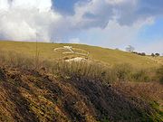
- Once through the woodland the path dips into the valley offering stunning views of the surrounding countryside and then continues through coppiced woodland to open meadow land and the village of CrundaleCrundale, KentCrundale is a village and civil parish in the Ashford District of Kent in southeast England. The village is located on the North Downs, about halfway between Ashford and Canterbury....
. The path follows an unmade road branching off to the left across farmland leading into dense woodland, where it is lined with yew trees. The walk follows several sections of woodland, and as you approach Chilham, you will see views of the castle. The path then branches to your left over a stile, this link path then takes you back down to the river to the picturesque Chilham mill.
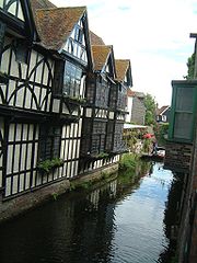
- For Chilham village square follow the road from the mill to the A28. The main square boasts timber framed houses, a 13th century church and the impressive castle gateway.
- For the railway station turn right at the main road and continue for approximately 150 metres then turn left – the station should be clearly signed.
Chilham to Canterbury
7 ½ miles (12 km) - to- Leaving ChilhamChilhamChilham is a parish in the English county of Kent. Visited by tourists worldwide, it is known for its beauty. Chilham has been a location for a number of films and television dramas...
village, head east across the river to pick up the main Stour Valley Walk, passing the NeolithicNeolithicThe Neolithic Age, Era, or Period, or New Stone Age, was a period in the development of human technology, beginning about 9500 BC in some parts of the Middle East, and later in other parts of the world. It is traditionally considered as the last part of the Stone Age...
long barrowLong barrowA long barrow is a prehistoric monument dating to the early Neolithic period. They are rectangular or trapezoidal tumuli or earth mounds traditionally interpreted as collective tombs...
, Julliberrie's GraveJulliberrie's GraveJulliberrie's Grave is an unchambered earthen Neolithic long barrow in the English county of Kent. It is situated near Chilham overlooking the River Stour on the Julliberrie Downs at Ordnance Survey, . The Stour Valley Walk passes close to the site....
and then follow the route north-east to Shalmsford Street, and on towards Thanington WithoutThanington WithoutThanington Without is a civil parish and Community in Canterbury Kent United Kingdom. It extends to the south-west of A2 to the Milton Bridge. The off ramp slip road is at present under construction on the East bound A2...
and CanterburyCanterburyCanterbury is a historic English cathedral city, which lies at the heart of the City of Canterbury, a district of Kent in South East England. It lies on the River Stour....
.
Canterbury to Upstreet
8 ½ miles (13.6 km) - toUpstreet to Sandwich
10 ½ miles (16.8 km) - toAt Upstreet the path joins the Saxon Shore Way
Saxon Shore Way
The Saxon Shore Way is a long-distance footpath in England, starting at Gravesend, Kent and traces the coast as it was in Roman times as far as Hastings, East Sussex, in total.-History:...
heading towards Sandwich
Sandwich, Kent
Sandwich is a historic town and civil parish on the River Stour in the Non-metropolitan district of Dover, within the ceremonial county of Kent, south-east England. It has a population of 6,800....
.
Sandwich to Pegwell Bay
3 ½ miles (5.6 km) - toSee also
- Long-distance footpaths in the UK