

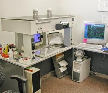
Stereoplotter
Encyclopedia
Stereoscopy
Stereoscopy refers to a technique for creating or enhancing the illusion of depth in an image by presenting two offset images separately to the left and right eye of the viewer. Both of these 2-D offset images are then combined in the brain to give the perception of 3-D depth...
s to determine elevations. It has been the primary method to plot contour line
Contour line
A contour line of a function of two variables is a curve along which the function has a constant value. In cartography, a contour line joins points of equal elevation above a given level, such as mean sea level...
s on topographic map
Topographic map
A topographic map is a type of map characterized by large-scale detail and quantitative representation of relief, usually using contour lines in modern mapping, but historically using a variety of methods. Traditional definitions require a topographic map to show both natural and man-made features...
s since the 1930’s. Although the specific devices have advanced technologically, they are all based on the apparent change in position of a feature in the two stereo photographs.
Stereoplotter process
The stereoplotter requires two photographPhotograph
A photograph is an image created by light falling on a light-sensitive surface, usually photographic film or an electronic imager such as a CCD or a CMOS chip. Most photographs are created using a camera, which uses a lens to focus the scene's visible wavelengths of light into a reproduction of...
s that have considerable overlap (60%) and are corrected for distortion due to angle of photo. The photos are put onto transparent media and projected with a light source. Each image will be projected with overlap on the other. The operator, using a special set of optics
Optics
Optics is the branch of physics which involves the behavior and properties of light, including its interactions with matter and the construction of instruments that use or detect it. Optics usually describes the behavior of visible, ultraviolet, and infrared light...
, would then see the image as three dimensional due to the differing perspective of each photo.
The optics of the stereoplotter is what allows the operator to plot the contours and features. The light source used to project the photo is what begins the process. One photo is projected using cyan
Cyan
Cyan from , transliterated: kýanos, meaning "dark blue substance") may be used as the name of any of a number of colors in the blue/green range of the spectrum. In reference to the visible spectrum cyan is used to refer to the color obtained by mixing equal amounts of green and blue light or the...
/ blue filter and the other photo is projected with a red filter. The operator wears a special set of glasses
Glasses
Glasses, also known as eyeglasses , spectacles or simply specs , are frames bearing lenses worn in front of the eyes. They are normally used for vision correction or eye protection. Safety glasses are a kind of eye protection against flying debris or against visible and near visible light or...
that have the same color filter for lenses. Seeing the left photo in blue light while the left eye has the blue filter and the right photo projected with red light and the right eye seeing through the red filter, the overlapping image becomes three-dimensional. The images will have control points that detail how the overlap of the photos should occur. The resultant overlapping image is called an anaglyph
Anaglyph
Anaglyph may refer to:* Anaglyph image, a method of encoding a three-dimensional image in a single picture by superimposing a pair of pictures* Ornament carved in low relief...
and is a three dimensional model of the terrain
Terrain
Terrain, or land relief, is the vertical and horizontal dimension of land surface. When relief is described underwater, the term bathymetry is used...
. Once the two photos are projected and the desired control points aligned the operator will then start to digitize the desired elevations on the terrain.
The stereoplotter serves an important need of allowing aerial photos to become the base for contour
Contour line
A contour line of a function of two variables is a curve along which the function has a constant value. In cartography, a contour line joins points of equal elevation above a given level, such as mean sea level...
s and elevation
Elevation
The elevation of a geographic location is its height above a fixed reference point, most commonly a reference geoid, a mathematical model of the Earth's sea level as an equipotential gravitational surface ....
maps. In the United States the largest use of topographic maps is the USGS (United States Geological Survey
United States Geological Survey
The United States Geological Survey is a scientific agency of the United States government. The scientists of the USGS study the landscape of the United States, its natural resources, and the natural hazards that threaten it. The organization has four major science disciplines, concerning biology,...
). The USGS has cataloged all of its land and produced topo-sheets for all of it. The sheets are most often used as 7.5' maps. This means there is 7.5' (.125 degrees) latitude
Latitude
In geography, the latitude of a location on the Earth is the angular distance of that location south or north of the Equator. The latitude is an angle, and is usually measured in degrees . The equator has a latitude of 0°, the North pole has a latitude of 90° north , and the South pole has a...
by 7.5' (.125 degrees) longitude
Longitude
Longitude is a geographic coordinate that specifies the east-west position of a point on the Earth's surface. It is an angular measurement, usually expressed in degrees, minutes and seconds, and denoted by the Greek letter lambda ....
.
Stereoplotter evolution
Stereoplotters have changed as technology has improved. The first stereoplotters where projection stereoplotters they used only the light rays and optics to adjust the image. The Kelsh Plotter is an example of the projection stereoplotters. The analog stereoplotters came next and were more sophisticated in that they used more sophisticated optics to view the image. The analytical stereoplotterAnalytical Stereoplotter
With the introduction of computers, the analytical stereoplotter became a popular machine of choice photogrammetry in the late 1960’s to 1970’s. A stereoplotter is an instrument that uses stereo photographs to determine elevations for the purpose of creating contours on topographic maps...
is used today. It incorporates a computer which does the work of mathematically aligning the images so that they line up properly. The analytic stereoplotter also allows for storing the data and redrawing at any desired scale.
Future outlook
LIDARLIDAR
LIDAR is an optical remote sensing technology that can measure the distance to, or other properties of a target by illuminating the target with light, often using pulses from a laser...
(LIght Detection And Ranging) has largely replaced the stereoplotter for gathering elevation data. LIDAR uses a laser pulse directed at features and detects the amount of time between when the pulse is emitted and when it is detected to determine the difference in elevations.
See also
- Analytical stereoplotterAnalytical StereoplotterWith the introduction of computers, the analytical stereoplotter became a popular machine of choice photogrammetry in the late 1960’s to 1970’s. A stereoplotter is an instrument that uses stereo photographs to determine elevations for the purpose of creating contours on topographic maps...
- Coincidence rangefinderCoincidence rangefinderA coincidence rangefinder is a type of rangefinder that uses mechanical and optical principles to allow an operator to determine the distance to a visible object....
- OrthophotoOrthophotoAn orthophoto, orthophotograph or orthoimage is an aerial photograph geometrically corrected such that the scale is uniform: the photo has the same lack of distortion as a map...
- PhotogrammetryPhotogrammetryPhotogrammetry is the practice of determining the geometric properties of objects from photographic images. Photogrammetry is as old as modern photography and can be dated to the mid-nineteenth century....
- PhotomappingPhotomappingPhotomapping involves the process of drawing a map from a photographic base. “In all likelihood, computer map making, including analogue processing, will have replaced manual map making for well over 90 per cent of all maps".-Principles and Definitions:...
- Topographic mapTopographic mapA topographic map is a type of map characterized by large-scale detail and quantitative representation of relief, usually using contour lines in modern mapping, but historically using a variety of methods. Traditional definitions require a topographic map to show both natural and man-made features...
- U.S. Geological Survey