

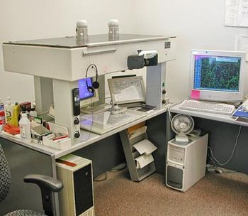
Analytical Stereoplotter
Encyclopedia
Photogrammetry
Photogrammetry is the practice of determining the geometric properties of objects from photographic images. Photogrammetry is as old as modern photography and can be dated to the mid-nineteenth century....
in the late 1960’s to 1970’s. A stereoplotter
Stereoplotter
A stereoplotter uses stereo photographs to determine elevations. It has been the primary method to plot contour lines on topographic maps since the 1930’s...
is an instrument that uses stereo photographs to determine elevations for the purpose of creating contours on topographic maps
Topographic map
A topographic map is a type of map characterized by large-scale detail and quantitative representation of relief, usually using contour lines in modern mapping, but historically using a variety of methods. Traditional definitions require a topographic map to show both natural and man-made features...
. Computers brought the capability to execute more precise calculations that ensure additional accurate output instead of approximations. This innovation also allowed a shift to a digital format rather than paper. Analytical stereoplotters edged out their analog predecessors and became the primary method of acquiring elevation
Elevation
The elevation of a geographic location is its height above a fixed reference point, most commonly a reference geoid, a mathematical model of the Earth's sea level as an equipotential gravitational surface ....
data from stereo photographs
Stereoscopy
Stereoscopy refers to a technique for creating or enhancing the illusion of depth in an image by presenting two offset images separately to the left and right eye of the viewer. Both of these 2-D offset images are then combined in the brain to give the perception of 3-D depth...
.
Projection system
Analytical stereoplotters use a math projection based on the co-linearityCollinearity equation
The collinearity equation is used in photogrammetry and remote sensing to relate coordinates in a sensor plane to object coordinates ....
(two vectors pointing in the same direction) equation model. The mechanical element of the device is a very accurate computer-controlled instrument that can view two photographs at the same time. The measurement system can be made to create a very precise and accurate measurement for images because the photo stages only move via the x and y coordinates that are programmed into the system. In comparison, to the analytical stereoplotter, the Kelsh stereoplotter was built with a fixed focal distance and focal length
Focal length
The focal length of an optical system is a measure of how strongly the system converges or diverges light. For an optical system in air, it is the distance over which initially collimated rays are brought to a focus...
of lens for projection. The ratio for scale was also fixed. On the other hand, the analytical stereoplotter has no substantial limitations on focal length or scale.
Viewing System
The analytical stereoplotters viewing system has an optical train system, which usually includes the ability to change the focal length of a camera by adjusting the lens. Style, size and color of the measuring mark can be adjusted in viewing system as well. There is also an illumination adjustment to each eye.Measuring and Tracing System
The analytical stereoplotter measuring system is made up of an input device for the operator to move the elevation point in three dimensions. The input device is programmed, and the digital measure of the elevation point deviation is sent to the computer. With this information, the program then is able to set and locate points for both the interior and exterior of the elevation and record measurements. The transfer of information is immediate and thus the person operating the machine is able to make any necessary adjustments to the coordinates.Elevations are measured in three steps, that include first measuring the interior orientation, then the relative orientation, and finally the absolute orientation. Interior orientation photographs are placed in relation to the center of the stereoplotter by aligning the fixed standard of reference points for measurement to corresponding points on the photograph. The focal length of the camera is also set. With relative orientation the angle of orientation of the camera relative to the place where the photos were the stereo-photo is taken programmed in the stereoplotter. This allows the effects of parallax (distortion of the final stereo-photo) to be reduced. In absolute orientation, the ground coordinates of a position are used to scale the model. You can use this to get the x, y, or z coordinates of any position on the stereo photographs. This information can be used for the construction of contour lines
Contour line
A contour line of a function of two variables is a curve along which the function has a constant value. In cartography, a contour line joins points of equal elevation above a given level, such as mean sea level...
for topographic maps.
Examples of Analytical Stereoplotters
- Galileo Digicart
- Intergraph Intermap
- Kern (now Leica) DSR series
- Wild (now Leica) AC and BC series,
- Zeiss Planicomp P series
- Matra Traster series
See also
- Leica Photogrammetry SuiteLeica Photogrammetry SuiteLeica Photogrammetry Suite is a software application for performing photogrammetric operations on imagery and extracting information from imagery...
- OrthophotoOrthophotoAn orthophoto, orthophotograph or orthoimage is an aerial photograph geometrically corrected such that the scale is uniform: the photo has the same lack of distortion as a map...
- PhotogrammetryPhotogrammetryPhotogrammetry is the practice of determining the geometric properties of objects from photographic images. Photogrammetry is as old as modern photography and can be dated to the mid-nineteenth century....
- PhotomappingPhotomappingPhotomapping involves the process of drawing a map from a photographic base. “In all likelihood, computer map making, including analogue processing, will have replaced manual map making for well over 90 per cent of all maps".-Principles and Definitions:...
- Topographic mapTopographic mapA topographic map is a type of map characterized by large-scale detail and quantitative representation of relief, usually using contour lines in modern mapping, but historically using a variety of methods. Traditional definitions require a topographic map to show both natural and man-made features...
- U.S. Geological Survey