
Staverton, Northamptonshire
Encyclopedia
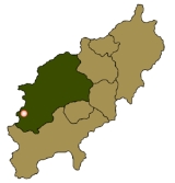
Staverton is a village and civil parish in the south-west of Northamptonshire
, England
. It is 2.3 miles west of Daventry
, 7.9 miles east of Southam
and 15.3 miles east of Leamington Spa
. It straddles the A425 road
from Daventry to Leamington.
The village sits on the edge of an escarpment and has views westward across the valley of the River Leam
into the neighbouring county of Warwickshire
. Both the Malvern
and Shropshire
hills are visible on fine days.
of 1086, Staverton is mentioned as Stavertone.
Before the early part of the 18th century, the original village was located behind the church. However, in 1720 a fire broke out which caused damage, destroying many hay
stacks, stables, grain stores and 22 houses. The total loss was thought to be around £3,000. The result of this was that the village received, via a bequest from Elizabeth Darby, a fire engine. This came into commission in 1767, was kept in the village until quite recently and was later housed at the Daventry museum. A plaque can be seen on a door opposite the village green to this effect.
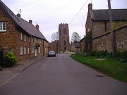
The village has a manor house
, situated at the end of Manor Road and thought to have parts originating possibly from Anglo-Saxon
times. It is only one of many examples of vernacular architecture in the village. There is an interesting window detail at The Stables in Manor Road. A datestone above the window reads R.R. 1684.
.jpg) Within the village, Well Lane runs parallel to the main A425
Within the village, Well Lane runs parallel to the main A425
. It has been conjectured that this was a much earlier approach to the village. The deeply banked sides to the lane bear testimony to it being an ancient right of way. Possibly, with the increase in coaching traffic from the west, the present A425 route was chosen in preference.
Along the western boundary of the parish runs the now-disused railway, the last mainline railway to be built in Britain. It was constructed by the Great Central Railway
Company between 1894 and 1899 and ran from Nottingham
to London Marylebone. A mission was established for the navvies in the village in a barn situated on the corner of Manor Road and Glebe Lane. This is now part of a private residence.
, which, at 225 m (738 ft), is the highest point in Northamptonshire. On the summit, evidence of an Iron Age
hill fort of an unusually square shape is plainly seen. The River Nene
rises nearby. The Jurassic Way
and the Three Rivers Circular Walk pass through the parish.
.
 St Mary the Virgin has been a site of Christian worship for well over a thousand years, although the first recorded vicar appears in records started in 1220. A board inside the church lists all subsequent vicars up to the present incumbent. The present church dates from about 1300 with some older parts. For hundreds of years before this, possibly dating back to before 800 AD, a burial ground existed on the site - as evidenced by the raised churchyard. The main structure that can be seen today dates mainly from the 14th century, although traces of older architecture still remain, such as the lancet window
in the north-west corner, which is from the Norman
period.
The church has many original architectural and historic features. From the top of the tower, sitting on top of one of the highest points in Northamptonshire, it is said that if one were able to travel eastwards maintaining the same altitude, one would not touch land again until reaching the Urals. The ‘new’ north porch, used as the main entrance into the church, dates back 600 years, whereas the south porch is 100 years older. The original door and roof timbers remain. The church has a peal of six bells cast in 1938 by John Taylor & Co of Loughborough. The vicar from 1933 to 1946, Rev. E.S. Powell, initiated the bell restoration; he and his wife were active bellringers.
-Daventry
-Rugby
, operated by Geoff Amos Coaches from Monday to Saturday.
, The Countryman, formerly known as the New Inn. Former Staverton pubs included The Windmill in Windmill Lane and The Crown, now a private house, opposite The Green. Across the road from the pub, there is a garage. There is a garden centre on the Badby Road out of the village. East of the village on the Daventry road is Staverton Park, where the facilities include an indoor leisure complex and an 18-hole golf course
and driving range
.
The first mention of a post office
in the village was in 1864, but the post office closed in March 2008.
Northamptonshire
Northamptonshire is a landlocked county in the English East Midlands, with a population of 629,676 as at the 2001 census. It has boundaries with the ceremonial counties of Warwickshire to the west, Leicestershire and Rutland to the north, Cambridgeshire to the east, Bedfordshire to the south-east,...
, England
England
England is a country that is part of the United Kingdom. It shares land borders with Scotland to the north and Wales to the west; the Irish Sea is to the north west, the Celtic Sea to the south west, with the North Sea to the east and the English Channel to the south separating it from continental...
. It is 2.3 miles west of Daventry
Daventry
Daventry is a market town in Northamptonshire, England, with a population of 22,367 .-Geography:The town is also the administrative centre of the larger Daventry district, which has a population of 71,838. The town is 77 miles north-northwest of London, 13.9 miles west of Northampton and 10.2...
, 7.9 miles east of Southam
Southam
Southam is a small market town in the Stratford-on-Avon district of Warwickshire, England. The 2001 census recorded a population of 6,509 in the town.The nearest sizeable town to Southam is Leamington Spa, located roughly 7 miles to the west...
and 15.3 miles east of Leamington Spa
Leamington Spa
Royal Leamington Spa, commonly known as Leamington Spa or Leamington or Leam to locals, is a spa town in central Warwickshire, England. Formerly known as Leamington Priors, its expansion began following the popularisation of the medicinal qualities of its water by Dr Kerr in 1784, and by Dr Lambe...
. It straddles the A425 road
A425 road
The A425 road is an A road in England, which runs between Daventry in Northamptonshire and Warwick in Warwickshire via Staverton, Lower Shuckburgh and Southam.At Southam it links with the A426 as well as the A423....
from Daventry to Leamington.
The village sits on the edge of an escarpment and has views westward across the valley of the River Leam
River Leam
The River Leam is a river which flows through eastern and southern Warwickshire. It is a small river about 25–30 miles long. The town of Leamington Spa lies on, and is named after, the River Leam....
into the neighbouring county of Warwickshire
Warwickshire
Warwickshire is a landlocked non-metropolitan county in the West Midlands region of England. The county town is Warwick, although the largest town is Nuneaton. The county is famous for being the birthplace of William Shakespeare...
. Both the Malvern
Malvern Hills
The Malvern Hills are a range of hills in the English counties of Worcestershire, Herefordshire and a small area of northern Gloucestershire, dominating the surrounding countryside and the towns and villages of the district of Malvern...
and Shropshire
Shropshire
Shropshire is a county in the West Midlands region of England. For Eurostat purposes, the county is a NUTS 3 region and is one of four counties or unitary districts that comprise the "Shropshire and Staffordshire" NUTS 2 region. It borders Wales to the west...
hills are visible on fine days.
History
The name Staverton means "staved town". In the Domesday BookDomesday Book
Domesday Book , now held at The National Archives, Kew, Richmond upon Thames in South West London, is the record of the great survey of much of England and parts of Wales completed in 1086...
of 1086, Staverton is mentioned as Stavertone.
Before the early part of the 18th century, the original village was located behind the church. However, in 1720 a fire broke out which caused damage, destroying many hay
Hay
Hay is grass, legumes or other herbaceous plants that have been cut, dried, and stored for use as animal fodder, particularly for grazing livestock such as cattle, horses, goats, and sheep. Hay is also fed to pets such as rabbits and guinea pigs...
stacks, stables, grain stores and 22 houses. The total loss was thought to be around £3,000. The result of this was that the village received, via a bequest from Elizabeth Darby, a fire engine. This came into commission in 1767, was kept in the village until quite recently and was later housed at the Daventry museum. A plaque can be seen on a door opposite the village green to this effect.
The village has a manor house
Manor house
A manor house is a country house that historically formed the administrative centre of a manor, the lowest unit of territorial organisation in the feudal system in Europe. The term is applied to country houses that belonged to the gentry and other grand stately homes...
, situated at the end of Manor Road and thought to have parts originating possibly from Anglo-Saxon
Anglo-Saxons
Anglo-Saxon is a term used by historians to designate the Germanic tribes who invaded and settled the south and east of Great Britain beginning in the early 5th century AD, and the period from their creation of the English nation to the Norman conquest. The Anglo-Saxon Era denotes the period of...
times. It is only one of many examples of vernacular architecture in the village. There is an interesting window detail at The Stables in Manor Road. A datestone above the window reads R.R. 1684.
A425 road
The A425 road is an A road in England, which runs between Daventry in Northamptonshire and Warwick in Warwickshire via Staverton, Lower Shuckburgh and Southam.At Southam it links with the A426 as well as the A423....
. It has been conjectured that this was a much earlier approach to the village. The deeply banked sides to the lane bear testimony to it being an ancient right of way. Possibly, with the increase in coaching traffic from the west, the present A425 route was chosen in preference.
Along the western boundary of the parish runs the now-disused railway, the last mainline railway to be built in Britain. It was constructed by the Great Central Railway
Great Central Railway
The Great Central Railway was a railway company in England which came into being when the Manchester, Sheffield and Lincolnshire Railway changed its name in 1897 in anticipation of the opening in 1899 of its London Extension . On 1 January 1923, it was grouped into the London and North Eastern...
Company between 1894 and 1899 and ran from Nottingham
Nottingham
Nottingham is a city and unitary authority in the East Midlands of England. It is located in the ceremonial county of Nottinghamshire and represents one of eight members of the English Core Cities Group...
to London Marylebone. A mission was established for the navvies in the village in a barn situated on the corner of Manor Road and Glebe Lane. This is now part of a private residence.
Geography
The average elevation of the parish is 700 ft above sea level, and approximately 1.5 miles south of the village is Arbury HillArbury Hill
Arbury Hill, at 225 m , is the highest point in the English county of Northamptonshire.It is southwest of the town of Daventry. The River Nene rises nearby.-Earthworks:...
, which, at 225 m (738 ft), is the highest point in Northamptonshire. On the summit, evidence of an Iron Age
Iron Age
The Iron Age is the archaeological period generally occurring after the Bronze Age, marked by the prevalent use of iron. The early period of the age is characterized by the widespread use of iron or steel. The adoption of such material coincided with other changes in society, including differing...
hill fort of an unusually square shape is plainly seen. The River Nene
River Nene
The River Nene is a river in the east of England that rises from three sources in the county of Northamptonshire. The tidal river forms the border between Cambridgeshire and Norfolk for about . It is the tenth longest river in the United Kingdom, and is navigable for from Northampton to The...
rises nearby. The Jurassic Way
Jurassic Way
The Jurassic Way is a designated and signed long-distance footpath that connects the Oxfordshire town of Banbury with the Lincolnshire town of Stamford in England...
and the Three Rivers Circular Walk pass through the parish.
Demography
Staverton parish had a population of 468 at the 2001 censusUnited Kingdom Census 2001
A nationwide census, known as Census 2001, was conducted in the United Kingdom on Sunday, 29 April 2001. This was the 20th UK Census and recorded a resident population of 58,789,194....
.
Landmarks
Lancet window
A lancet window is a tall narrow window with a pointed arch at its top. It acquired the "lancet" name from its resemblance to a lance. Instances of this architectural motif are most often found in Gothic and ecclesiastical structures, where they are often placed singly or in pairs.The motif first...
in the north-west corner, which is from the Norman
Norman architecture
About|Romanesque architecture, primarily English|other buildings in Normandy|Architecture of Normandy.File:Durham Cathedral. Nave by James Valentine c.1890.jpg|thumb|200px|The nave of Durham Cathedral demonstrates the characteristic round arched style, though use of shallow pointed arches above the...
period.
The church has many original architectural and historic features. From the top of the tower, sitting on top of one of the highest points in Northamptonshire, it is said that if one were able to travel eastwards maintaining the same altitude, one would not touch land again until reaching the Urals. The ‘new’ north porch, used as the main entrance into the church, dates back 600 years, whereas the south porch is 100 years older. The original door and roof timbers remain. The church has a peal of six bells cast in 1938 by John Taylor & Co of Loughborough. The vicar from 1933 to 1946, Rev. E.S. Powell, initiated the bell restoration; he and his wife were active bellringers.
Transport
There is an hourly low-floor bus service "GA01" between BanburyBanbury
Banbury is a market town and civil parish on the River Cherwell in the Cherwell District of Oxfordshire. It is northwest of London, southeast of Birmingham, south of Coventry and north northwest of the county town of Oxford...
-Daventry
Daventry
Daventry is a market town in Northamptonshire, England, with a population of 22,367 .-Geography:The town is also the administrative centre of the larger Daventry district, which has a population of 71,838. The town is 77 miles north-northwest of London, 13.9 miles west of Northampton and 10.2...
-Rugby
Rugby, Warwickshire
Rugby is a market town in Warwickshire, England, located on the River Avon. The town has a population of 61,988 making it the second largest town in the county...
, operated by Geoff Amos Coaches from Monday to Saturday.
Amenities
There is one public housePublic house
A public house, informally known as a pub, is a drinking establishment fundamental to the culture of Britain, Ireland, Australia and New Zealand. There are approximately 53,500 public houses in the United Kingdom. This number has been declining every year, so that nearly half of the smaller...
, The Countryman, formerly known as the New Inn. Former Staverton pubs included The Windmill in Windmill Lane and The Crown, now a private house, opposite The Green. Across the road from the pub, there is a garage. There is a garden centre on the Badby Road out of the village. East of the village on the Daventry road is Staverton Park, where the facilities include an indoor leisure complex and an 18-hole golf course
Golf course
A golf course comprises a series of holes, each consisting of a teeing ground, fairway, rough and other hazards, and a green with a flagstick and cup, all designed for the game of golf. A standard round of golf consists of playing 18 holes, thus most golf courses have this number of holes...
and driving range
Driving range
A driving range is an area where golfers can practice their swing. It can also be a recreational activity itself for amateur golfers or when enough time for a full game is not available. Many golf courses have a driving range attached and they are also found as stand-alone facilities, especially...
.
The first mention of a post office
Post office
A post office is a facility forming part of a postal system for the posting, receipt, sorting, handling, transmission or delivery of mail.Post offices offer mail-related services such as post office boxes, postage and packaging supplies...
in the village was in 1864, but the post office closed in March 2008.