St Helens, Isle of Wight
Encyclopedia


Civil parish
In England, a civil parish is a territorial designation and, where they are found, the lowest tier of local government below districts and counties...
located on the eastern side of the Isle of Wight
Isle of Wight
The Isle of Wight is a county and the largest island of England, located in the English Channel, on average about 2–4 miles off the south coast of the county of Hampshire, separated from the mainland by a strait called the Solent...
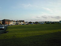
. The village is based around village green
Village green
A village green is a common open area which is a part of a settlement. Traditionally, such an area was often common grass land at the centre of a small agricultural settlement, used for grazing and sometimes for community events...
s. This is claimed to be the largest in England but some say the Village Green is the second largest. The greens are often used for cricket
Cricket
Cricket is a bat-and-ball game played between two teams of 11 players on an oval-shaped field, at the centre of which is a rectangular 22-yard long pitch. One team bats, trying to score as many runs as possible while the other team bowls and fields, trying to dismiss the batsmen and thus limit the...
matches during the summer and football in the winter and also include a children's playground. The local pub is The Vine. The village also has two restaurants, Ganders on the upper side of the green and St Helens Restaurant on the south.
The village is a short distance from the coast, with about a ten minute walk to St Helens Duver
Duver
A duver is an Isle of Wight dialect term for an area of sand dunes. The name has become part of place names on the Isle of Wight, for example Dover Street in Ryde is the street which used to run down to the duver....
, which was once the location of the Island's first golf course
Golf course
A golf course comprises a series of holes, each consisting of a teeing ground, fairway, rough and other hazards, and a green with a flagstick and cup, all designed for the game of golf. A standard round of golf consists of playing 18 holes, thus most golf courses have this number of holes...
. It is now a popular beach for tourists during the summer season and is protected by the National Trust
National Trust for Places of Historic Interest or Natural Beauty
The National Trust for Places of Historic Interest or Natural Beauty, usually known as the National Trust, is a conservation organisation in England, Wales and Northern Ireland...
.
It is linked to other parts of the Island by Southern Vectis
Southern Vectis
The Southern Vectis Omnibus Company Limited is the dominant bus operator on the Isle of Wight. It was purchased by the Go-Ahead Group in 2005 and is a part of the company's Go South Coast division. The firm employs 299 staff, with 105 single deck, double deck and open-top buses and coaches...
bus route 8
Southern Vectis route 8
Southern Vectis route 8 is a bus service operated on the Isle of Wight by Southern Vectis between Newport and Ryde. The route travels via Pan Estate, Robin Hill, Arreton, Winford, Lake, Sandown, Yaverland, Bembridge, St Helens, Nettlestone, Seaview and Pondwell. The general daytime frequency of the...
serving Ryde
Ryde
Ryde is a British seaside town, civil parish and the most populous town and urban area on the Isle of Wight, with a population of approximately 30,000. It is situated on the north-east coast. The town grew in size as a seaside resort following the joining of the villages of Upper Ryde and Lower...
, Bembridge
Bembridge
Bembridge is an affluent village and civil parish located on the easternmost point of the Isle of Wight. It had a population of 3,848 according to the 2001 census of the United Kingdom, leading to claims by residents that Bembridge is the largest village in England, and occasional claims that it is...
, Sandown
Sandown
Sandown is a seaside resort town and civil parish on the southeast coast of the Isle of Wight, England, neighbouring the town of Shanklin to the south. Sandown Bay is the name of the bay off the English Channel which both towns share, and it is notable for its long stretch of easily accessible...
and Newport
Newport, Isle of Wight
Newport is a civil parish and a county town of the Isle of Wight, an island off the south coast of England. Newport has a population of 23,957 according to the 2001 census...
including intermediate villages.
History
The origins of St. Helens seems to revolve around the Cluniac Priory and the monastic church, built circa 1080. In 1340 a French raid landed at St Helens but was repulsed by Sir Theobald Russell. In 1346 Edward IIIEdward III of England
Edward III was King of England from 1327 until his death and is noted for his military success. Restoring royal authority after the disastrous reign of his father, Edward II, Edward III went on to transform the Kingdom of England into one of the most formidable military powers in Europe...
set sail from St Helens to invade Normandy
Normandy
Normandy is a geographical region corresponding to the former Duchy of Normandy. It is in France.The continental territory covers 30,627 km² and forms the preponderant part of Normandy and roughly 5% of the territory of France. It is divided for administrative purposes into two régions:...
.
After the alien priories were suppressed by Henry V
Henry V of England
Henry V was King of England from 1413 until his death at the age of 35 in 1422. He was the second monarch belonging to the House of Lancaster....
in 1414 the old church became the parish church. The original church eventually became unsafe, and a new church was built further inland. In 1720 a great wave destroyed the old church. At this time the entrance to the harbour was near to the Church, being moved due to attempts at reclamation of the harbour which was unsuccessful due to locals removing building materials. The church was undermined by the quarrying of stone from the beach, which accounts for the large dressed blocks leading along the beach to Priory Bay
Priory Bay
Priory Bay is a small privately owned bay on the north east coast of the Isle of Wight, England. It lies to the east of the village of Nettlestone. It faces east towards Selsey Bill and its shoreline is 600m in length. It stretches from Horestone Point in the north to Nodes Point in the south.The...
. The entrance was defended by a small gun battery, which has been lost to the sea.
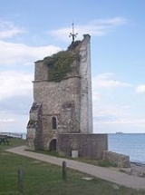
The tower still stands to this day, the seaward side is painted as a seamark. It is believed that Admiral Lord Nelson's last view of England was of the St Helen's seamark - HMS Victory had anchored nearby to collect drinking water, before setting sail for Cadiz
Cádiz
Cadiz is a city and port in southwestern Spain. It is the capital of the homonymous province, one of eight which make up the autonomous community of Andalusia....
and participation in the Battle of Trafalgar
Battle of Trafalgar
The Battle of Trafalgar was a sea battle fought between the British Royal Navy and the combined fleets of the French Navy and Spanish Navy, during the War of the Third Coalition of the Napoleonic Wars ....
.
Dressed stones from the walls of the destroyed church, which were soft sandstone, were found to be good for scrubbing the decks of wooden planked warships - hence the terms 'Holystone
Holystone
Holystone is a soft and brittle sandstone that was formerly used for scouring and whitening the wooden decks of ships. It was used in the British and American Navy for scrubbing the decks of sailing ships....
' and 'holystoning the decks'.
The closest Royal Commission
Royal Commission on the Defence of the United Kingdom
In 1859 Lord Palmerston instigated the Royal Commission on the Defence of the United Kingdom because of serious concerns that France might attempt to invade the UK...
sea fort to the Island is named after St. Helens St Helens Fort
St Helens Fort
St Helens Fort was built between 1867 and 1880 as a result of the Royal Commission, in the Solent close in to the Isle of Wight to protect the St Helens Road anchorage, it suffered badly from subsidence which forced many changes to the plans, ending up with two 10-inch 18-ton rifled muzzle loading ...
.
St Helens is still host to a number of families who have been residents for over 300 years. Common St Helens names include ATTRILL, BENNETT, BURDEN, HENLEY, JACOBS, PHILLIPS, TOOGOOD and WADE.
Geography
St Helens is located to the east of the Isle of Wight on high ground to the north of BembridgeBembridge
Bembridge is an affluent village and civil parish located on the easternmost point of the Isle of Wight. It had a population of 3,848 according to the 2001 census of the United Kingdom, leading to claims by residents that Bembridge is the largest village in England, and occasional claims that it is...
giving it views over the busy harbour. The nearest town is Ryde
Ryde
Ryde is a British seaside town, civil parish and the most populous town and urban area on the Isle of Wight, with a population of approximately 30,000. It is situated on the north-east coast. The town grew in size as a seaside resort following the joining of the villages of Upper Ryde and Lower...
, about 3 miles away.
The village is located on the coast, with St Helens Duver
Duver
A duver is an Isle of Wight dialect term for an area of sand dunes. The name has become part of place names on the Isle of Wight, for example Dover Street in Ryde is the street which used to run down to the duver....
nearby at the mouth of the harbour. The area features a sand-dune complex where the first golf course on the island was located, and where there is now a popular sheltered beach, cafe and beach huts. The Duver is no longer a golf course and is maintained by the National Trust
National Trust for Places of Historic Interest or Natural Beauty
The National Trust for Places of Historic Interest or Natural Beauty, usually known as the National Trust, is a conservation organisation in England, Wales and Northern Ireland...
, who also offer limited self-catering accommodation for holiday-makers in the area. A promenade stretches along the beach, with the sand dunes at the rear. During the summer season the beach is litter picked, with large amounts of seaweed removed and given to local farmers for composting. In 1997, the beach was given a Seaside Award Flag.
The Eastern Yar
Eastern Yar
The River Yar on the Isle of Wight, England, rises in a chalk coomb in St. Catherine's Down near Niton, close to the southern point of the island...
, from its source at Niton
Niton, Isle of Wight
Niton is a village on the Isle of Wight, near Ventnor with a thriving population of 1142, supporting two pubs, several churches,a pottery workshop/shop, a pharmacy and 3 local shops including a post office...
to the south of the island runs through the village en route to the Solent
Solent
The Solent is a strait separating the Isle of Wight from the mainland of England.The Solent is a major shipping route for passengers, freight and military vessels. It is an important recreational area for water sports, particularly yachting, hosting the Cowes Week sailing event annually...
.
St Helens' built environment
Built environment
The term built environment refers to the human-made surroundings that provide the setting for human activity, ranging in scale from personal shelter and buildings to neighborhoods and cities that can often include their supporting infrastructure, such as water supply or energy networks.The built...
is set around large village greens, which are often claimed to make up the second largest green in England. The greens are split up in some areas to allow for roads, with housing and other development to the north and south sides of the greens.
Amenities
St. Helen's ChurchSt. Helen's Church, St. Helens
St. Helen's Church, St. Helens is a parish church in the Church of England located in St Helens on the Isle of Wight.-History:The church was built originally in 1717 and was rebuilt in 1831 and the chancel in 1862....
is the village's Church of England
Church of England
The Church of England is the officially established Christian church in England and the Mother Church of the worldwide Anglican Communion. The church considers itself within the tradition of Western Christianity and dates its formal establishment principally to the mission to England by St...
Parish church
Parish church
A parish church , in Christianity, is the church which acts as the religious centre of a parish, the basic administrative unit of episcopal churches....
located just outside the main village. It was first built in 1717 but then rebuilt in 1831. The present church is a stone structure with brick dressings, and consists of an aisleless nave, with transepts, a chancel, and west tower with one bell.
The village has two restaurants, The Ganders is set on the upper side of the village green. St Helen's Restaurant is on the south and recently featured on Channel 4
Channel 4
Channel 4 is a British public-service television broadcaster which began working on 2 November 1982. Although largely commercially self-funded, it is ultimately publicly owned; originally a subsidiary of the Independent Broadcasting Authority , the station is now owned and operated by the Channel...
's Relocation Relocation. In addition to the two restaurants, the village's pub is The Vine Inn; situated opposite the village green, it is over 100 years old. Until the late 1960s it was adjoined by a rival pub, "The Sailors Home".
The village's only school is known as St Helen's Primary School, with 61 pupils currently on roll making it one of the smallest on the island. For much of 2008 it looked likely that the school would be closed following education reforms
Education reforms on the Isle of Wight
Education reforms on the Isle of Wight is part of a process to change the Isle of Wight's education from a three-tier system to a two-tier system. The debate as to how this should occur was first started in 2004, lasting until 2008. Three options were put forward at the start of 2008 as to what...
to move the island to a two-tier education system. The village protested with signs displayed across the village stating "We love St Helens Primary School". However in March 2009 the school was saved from closure.
The village also has a Newsagent, Post Office and grocery store, bookshop and garage. The Baywatch Café is located on the seafront and the Priory Bay Hotel close by.
Famous residents
- Jeremy IronsJeremy IronsJeremy John Irons is an English actor. After receiving classical training at the Bristol Old Vic Theatre School, Irons began his acting career on stage in 1969, and has since appeared in many London theatre productions including The Winter's Tale, Macbeth, Much Ado About Nothing, The Taming of the...
- film actor and OscarAcademy AwardsAn Academy Award, also known as an Oscar, is an accolade bestowed by the American Academy of Motion Picture Arts and Sciences to recognize excellence of professionals in the film industry, including directors, actors, and writers...
and double-Emmy winner - Sophie Dawes, Baronne de FeuchèresSophie Dawes, Baronne de FeuchèresSophie Dawes , Baronne de Feuchères by marriage, was an English "adventuress" best known as a mistress of Louis Henry II, Prince of Condé....
, "adventuress" best known as a mistress of Louis Henry II, Prince of CondéLouis Henry II, Prince of CondéLouis Henri de Bourbon was the Prince of Condé from 1818 to his death.-Life:He was the only son of Louis Joseph, Prince of Condé and his wife, Charlotte de Rohan.... - Alfred Toogood - Professional Golfer who lived at Eddington Road and played at the Royal Links club
It is believed that 'The Beatles' stayed in St Helens while attending the Isle of Wight Festival between 1967-1970 and were taxied to the festival site at Afton Down, Freshwater.

