
St Abb's Head
Encyclopedia
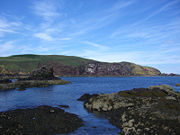
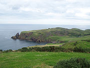
Promontory
Promontory may refer to:*Promontory, a prominent mass of land which overlooks lower lying land or a body of water*Promontory, Utah, the location where the United States first Transcontinental Railroad was completed...
at the village of St. Abbs
St. Abbs
St. Abbs , historically known as Coldingham Shore, is a small fishing village located on the south east coast of Scotland, in the Berwickshire area of Scottish Borders....
, Berwickshire
Berwickshire
Berwickshire or the County of Berwick is a registration county, a committee area of the Scottish Borders Council, and a lieutenancy area of Scotland, on the border with England. The town after which it is named—Berwick-upon-Tweed—was lost by Scotland to England in 1482...
, Scottish Borders
Scottish Borders
The Scottish Borders is one of 32 local government council areas of Scotland. It is bordered by Dumfries and Galloway in the west, South Lanarkshire and West Lothian in the north west, City of Edinburgh, East Lothian, Midlothian to the north; and the non-metropolitan counties of Northumberland...
, and a National Nature Reserve
National Nature Reserve
For details of National nature reserves in the United Kingdom see:*National Nature Reserves in England*National Nature Reserves in Northern Ireland*National Nature Reserves in Scotland*National Nature Reserves in Wales...
administered by the National Trust of Scotland. It lies on the eastern coast of Scotland
Scotland
Scotland is a country that is part of the United Kingdom. Occupying the northern third of the island of Great Britain, it shares a border with England to the south and is bounded by the North Sea to the east, the Atlantic Ocean to the north and west, and the North Channel and Irish Sea to the...
, United Kingdom
United Kingdom
The United Kingdom of Great Britain and Northern IrelandIn the United Kingdom and Dependencies, other languages have been officially recognised as legitimate autochthonous languages under the European Charter for Regional or Minority Languages...
at 55°55′0"N 02°08′3"W
(Note the lack of apostrophe in the name of the village.)
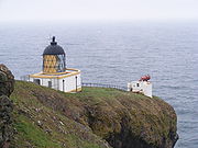
Lighthouse
A signal station was established on the cliffs before 1820 and the facilities were shared by Trinity HouseTrinity House
The Corporation of Trinity House of Deptford Strond is the official General Lighthouse Authority for England, Wales and other British territorial waters...
and Her Majesty's Coastguard
Her Majesty's Coastguard
Her Majesty's Coastguard is the service of the government of the United Kingdom concerned with co-ordinating air-sea rescue.HM Coastguard is a section of the Maritime and Coastguard Agency responsible for the initiation and co-ordination of all civilian maritime Search and Rescue within the UK...
. The Northern Lighthouse Board
Northern Lighthouse Board
The Northern Lighthouse Board is the General Lighthouse Authority for Scotland and the Isle of Man. It is a non-departmental public body responsible for marine navigation aids around coastal areas.-History:...
recommended the building of a lighthouse at St. Abbs Head after the sinking of the "Martello" on Carr Rock in 1857. The lighthouse was designed and built by the brothers David Stevenson
David Stevenson (engineer)
David Stevenson FRSE FRSSA was a Scottish lighthouse designer, who designed over thirty lighthouses in and around Scotland, and helped found a great dynasty of lighthouse engineering.-Background:...
and Thomas Stevenson
Thomas Stevenson
Thomas Stevenson PRSE MInstCE FRSSA FSAScot was a pioneering Scottish lighthouse designer and meteorologist, who designed over thirty lighthouses in and around Scotland, as well as the Stevenson screen used in meteorology...
and assisted navigation before and after sight of the Bell Rock
Inchcape
Inchcape or the Bell Rock is a notorious reef off the east coast of Angus, Scotland, near Dundee and Fife . Bell Rock Lighthouse, an automatic lighthouse, occupies the reef...
and Isle of May
Isle of May
The Isle of May is located in the north of the outer Firth of Forth, approximately off the coast of mainland Scotland. It is 1.8 km long and less than half a kilometre wide...
lights disappeared from view. The light began service on February 24, 1862 and initially used oil to generate its light, it was converted to incandescent
Incandescence
Incandescence is the emission of light from a hot body as a result of its temperature. The term derives from the Latin verb incandescere, to glow white....
power in 1906 and to electricity in 1966 and finally automated in 1993. Before automation the lighthouse was staffed by three full time keepers whose duties included keeping detailed weather records. The lighthouse has two km of single track tarmaced road leading to it from the main road near St. Abbs village, however it is suggested by the National Trust of Scotland that it is only used by disabled visitors and there is limited parking. Visitors can walk to the Head where the lighthouse's buildings, though still in good repair, are not open to the public. A foghorn
Foghorn
A foghorn or fog signal or fog bell is a device that uses sound to warn vehicles of hazards or boats of the presence of other vehicles in foggy conditions. The term is most often used in relation to marine transport...
was established at the Head in 1876, being the first audible fog signal in Scotland. The original foghorn was driven by hot air engines before being replaced by oil driven ones in 1911 and then by diesel engine
Diesel engine
A diesel engine is an internal combustion engine that uses the heat of compression to initiate ignition to burn the fuel, which is injected into the combustion chamber...
s in December 1955. The fog signal was discontinued in 1987 although the horn is still in place and can be reached at the edge of the cliffs by a railed path from the lighthouse.
National Nature Reserve
Land around St. Abb's Head is a National Nature ReserveNational Nature Reserves in Scotland
National Nature Reserves in Scotland are established by Scottish Natural Heritage. Until 2004 there were 73 National Nature Reserves in Scotland, as per the list below...
(NNR); this is managed by the National Trust for Scotland
National Trust for Scotland
The National Trust for Scotland for Places of Historic Interest or Natural Beauty, commonly known as the National Trust for Scotland describes itself as the conservation charity that protects and promotes Scotland's natural and cultural heritage for present and future generations to...
(NTS) in co-operation with Scottish Natural Heritage
Scottish Natural Heritage
Scottish Natural Heritage is a Scottish public body. It is responsible for Scotland's natural heritage, especially its natural, genetic and scenic diversity. It advises the Scottish Government and acts as a government agent in the delivery of conservation designations, i.e...
. The first part was purchased in 1980, with the Lumsdaine coastal strip being donated by Pearl Assurance Company Ltd. in 1984. Blackpotts grazings were purchased in 1994. The Head was designated an NNR because of the presence of a 60,000 strong seabird colony which nest on the sheer cliffs, stacks and gullies. Kittiwake
Kittiwake
The kittiwakes are two closely related seabird species in the gull family Laridae, the Black-legged Kittiwake and the Red-legged Kittiwake . The epithets "Black-legged" and "Red-legged" are used to distinguish the two species in North America, but in Europe, where R...
s and Guillemot
Guillemot
Guillemots is the common name for several species of seabird in the auk family . In British use, the term comprises two genera: Uria and Cepphus. In North America the Uria species are called "murres" and only the Cepphus species are called "guillemots"...
s are the most numerous species of the nesting birds followed by Razorbill
Razorbill
The Razorbill is colonial seabird that will only come to land in order to breed. It is the largest living member of the Auk family. This agile bird will choose only one partner for life and females will lay one egg per year. Razorbills will nest along coastal cliffs in enclosed or slightly exposed...
s, Shags, Herring Gulls, Fulmar
Fulmar
Fulmars are seabirds of the family Procellariidae. The family consists of two extant species and two that are extinct.-Taxonomy:As members of Procellaridae and then the order Procellariiformes, they share certain traits. First, they have nasal passages that attach to the upper bill called...
s and Puffin
Puffin
Puffins are any of three small species of auk in the bird genus Fratercula with a brightly coloured beak during the breeding season. These are pelagic seabirds that feed primarily by diving in the water. They breed in large colonies on coastal cliffs or offshore islands, nesting in crevices among...
s. To preserve the marine habitat, the NTS in conjunction with the Scottish Wildlife Trust
Scottish Wildlife Trust
The Scottish Wildlife Trust is a registered charity dedicated to conserving the wildlife and natural environment of Scotland.-Description:The Scottish Wildlife Trust has over 32,800 members...
, the local fishing community and diving clubs, have set up a Voluntary Marine Reserve which stretches south down the coast to the town of Eyemouth
Eyemouth
Eyemouth , historically spelt Aymouth, is a small town and civil parish in Berwickshire, in the Scottish Borders area of Scotland. It is east of the main north-south A1 road and just north of Berwick-upon-Tweed. It has a population of circa 3,420 people .The town's name comes from its location at...
. Although best known for its seabirds, the Reserve also has flower rich grasslands and a freshwater loch
Loch
Loch is the Irish and Scottish Gaelic word for a lake or a sea inlet. It has been anglicised as lough, although this is pronounced the same way as loch. Some lochs could also be called a firth, fjord, estuary, strait or bay...
.
The grazing on the Head is leased by the Trust to Northfield Farm which stands just to the south of the Head near St. Abbs village. The grassland is surprisingly rich for a coastal situation, in some places it is possible to find over 20 different species of plant in one square metre. There are at least 10 different kinds of butterfly on the Head including the Northern Brown Argus
Northern Brown Argus
The Northern Brown Argus is a butterfly in the family Lycaenidae.-Appearance, behaviour and distribution:This species has confused British entomologists for years. Since its discovery in Britain it has been thought to be a form or a subspecies of the Brown Argus Aricia agestis and as well as a...
which is a nationally rare butterfly in the UK
United Kingdom
The United Kingdom of Great Britain and Northern IrelandIn the United Kingdom and Dependencies, other languages have been officially recognised as legitimate autochthonous languages under the European Charter for Regional or Minority Languages...
. The butterflies drink nectar from the flowers of the Wild Thyme and the caterpillars eat the leaves of Rock Rose
Cistaceae
The Cistaceae is a small family of plants known for its beautiful shrubs, which are profusely covered by flowers at the time of blossom...
, the areas in which these two plants grow are protected from sheep grazing by fencing. Just inland from the lighthouse is Mire Loch
Mire Loch
Mire Loch is a man made freshwater loch situated on St Abb's Head in the Scottish Borders, just over a kilometre NW of the village of St. Abbs at grid reference . The loch lies on land owned by the National Trust for Scotland and is approximately 600 metres long by 50 metres at its widest...
, a 600 metre long artificially created lake.
National Trust for Scotland
The NTS has an information point for St. Abb's Head located at Northfield Farm , it has an exhibition with information about the Head, coffee shop, art gallery and textile shop. There are maps describing the walk to the Head and as well as Ranger led guided walks.The St Abbs Visitor Centre
March 2011 saw the opening of the latest addition to the many attractions of St Abbs in the form of the new St Abbs Visitor Centre. This state-of-the-art facility is located in St Abbs old village hall, perched precariously on a cliff edge. Built as a resource for both visitors and locals, the Centre offers free admission, interactive exhibits, library area, web access, stunning photographs and historical artefacts. It is an ideal starting point to a visit to St Abbs, giving information on the history of the village, the geology and also the local flora and fauna visitors are likely to encounter. The position of the building offers a stunning 180 degree view from St Abbs Head all the way to the harbour and beyond. The St Abbs Visitor Centre is an independent Scottish charity.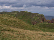
Geology
The layered sedimentary rockSedimentary rock
Sedimentary rock are types of rock that are formed by the deposition of material at the Earth's surface and within bodies of water. Sedimentation is the collective name for processes that cause mineral and/or organic particles to settle and accumulate or minerals to precipitate from a solution....
s of greywacke
Greywacke
Greywacke or Graywacke is a variety of sandstone generally characterized by its hardness, dark color, and poorly sorted angular grains of quartz, feldspar, and small rock fragments or lithic fragments set in a compact, clay-fine matrix. It is a texturally immature sedimentary rock generally found...
and siltstone
Siltstone
Siltstone is a sedimentary rock which has a grain size in the silt range, finer than sandstone and coarser than claystones.- Description :As its name implies, it is primarily composed of silt sized particles, defined as grains 1/16 - 1/256 mm or 4 to 8 on the Krumbein phi scale...
which lie to the north and south of the Head were laid down at the bottom of the sea between 460 and 410 million years ago. The Head itself is made from hard volcanic rock which formed as lava
Lava
Lava refers both to molten rock expelled by a volcano during an eruption and the resulting rock after solidification and cooling. This molten rock is formed in the interior of some planets, including Earth, and some of their satellites. When first erupted from a volcanic vent, lava is a liquid at...
flowed from volcano
Volcano
2. Bedrock3. Conduit 4. Base5. Sill6. Dike7. Layers of ash emitted by the volcano8. Flank| 9. Layers of lava emitted by the volcano10. Throat11. Parasitic cone12. Lava flow13. Vent14. Crater15...
es around 400 million years ago. The different type of rocks accounts for the contrast in colour between the rocks of the Head and those of mainland cliffs. The softer sedimentary rocks have eroded over time, leaving behind the high headland made from the harder rock. However even this tough volcanic rock has been affected by the actions of the sea, leaving steep gullies and sea stacks which are ideal for nesting sea birds. The harder rocks of the Head are separated from the sedimentary rock to the SW by the NW slanting St. Abbs Head Fault which is marked by a low lying valley which at times of higher sea level would have been flooded, cutting off the headland from the mainland.
History
Just 0.5 km to the SE of the lighthouse is Kirk Hill. On the summit of this hill are the remains of the 7th century monastery settlement of Saint ÆbbeAebbe the Elder
Saint Æbbe the Elder founded monasteries at Ebchester and St Abb's Head near Coldingham in Scotland.-Early life:Æbbe was a princess, the daughter of King Æthelfrith of Bernicia and Acha of Deira. Æthelfrith had invaded the neighbouring kingdom of Deira in 604. Assuming the throne, he united Deira...
. About AD 643 Æbbe established the monastery on Kirk Hill within the remains of a 6th century fort known as Urbs Coludi (Colud's Fort). Both Monks and Nuns lived at the monastery in basic beehive huts
Beehive house
A beehive house is a building made from a circle of stones topped with a domed roof. The name comes from the similarity in shape to a straw beehive.The ancient Bantu used this type of house, which was made with mud, poles, and cow dung....
made from mud and branches. Æbbe remained as abbess
Abbess
An abbess is the female superior, or mother superior, of a community of nuns, often an abbey....
until her death around 680, a few years later the monastery was accidentally burned down and was not replaced. The settlement was protected by a massive three metre high turf rampart on the landward side, the remains of this rampart can be seen as a low ridge around the rim of the hill. These are the only remnants of the 7th century monastic settlement of Æbbe. However there are faint outlines of buildings, field boundaries and a rectangular burial site dating from the 12th century. These are the scant traces of a Benedictine
Benedictine
Benedictine refers to the spirituality and consecrated life in accordance with the Rule of St Benedict, written by Benedict of Nursia in the sixth century for the cenobitic communities he founded in central Italy. The most notable of these is Monte Cassino, the first monastery founded by Benedict...
chapel established in 1188 and dedicated to Æbbe by monks from Coldingham Priory
Coldingham Priory
Coldingham Priory was a house of Benedictine monks. It lies on the south-east coast of Scotland, in the village of Coldingham, Berwickshire. Coldingham Priory was founded in the reign of David I of Scotland, although his older brother and predecessor King Edgar of Scotland had granted the land of...
.
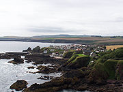
Salmon
Salmon is the common name for several species of fish in the family Salmonidae. Several other fish in the same family are called trout; the difference is often said to be that salmon migrate and trout are resident, but this distinction does not strictly hold true...
as they swim down the coast. A fishing station was established here in 1880 and lasted until around 1950. A jetty was also built in the bay so supplies could be landed for the lighthouse.
See also
The National Trust for Scotland has three further properties in the Scottish Borders:- Harmony GardenHarmony Garden, Scottish BordersThe Harmony Garden is a garden at Melrose, Scotland, in the Scottish Borders area of Scotland, administered by the National Trust for Scotland.The National Trust for Scotland has three further properties in the Scottish Borders:*Priorwood Garden in Melrose...
, MelroseMelrose, ScotlandMelrose is a small town and civil parish in the Scottish Borders, historically in Roxburghshire. It is in the Eildon committee area.-Etymology:... - Priorwood GardenPriorwood GardenPriorwood Garden is a garden in Melrose in the Scottish Borders area of Scotland. It is administered by the National Trust for Scotland.The National Trust for Scotland has three further properties in the Scottish Borders:* Harmony Garden, also in Melrose...
, also in Melrose - Robert Smail's Printing WorksRobert Smail's Printing WorksRobert Smail's Printing Works is a fully functional Victorian era letterpress printing works in the small Scottish Borders town of Innerleithen, now preserved by The National Trust for Scotland as an Industrial Heritage museum showing visitors the operation of a local printer around 1900 while...
at InnerleithenInnerleithenInnerleithen is a small town in the committee area of Tweeddale, in the Scottish Borders.-Etymology:The name "Innerleithen" comes from the Scottish Gaelic meaning "confluence of the Leithen", because it is here that the river joins the Tweed. The prefix "Inner-/Inver-" is common in many Scottish...
- St ÆbbeAebbe the ElderSaint Æbbe the Elder founded monasteries at Ebchester and St Abb's Head near Coldingham in Scotland.-Early life:Æbbe was a princess, the daughter of King Æthelfrith of Bernicia and Acha of Deira. Æthelfrith had invaded the neighbouring kingdom of Deira in 604. Assuming the throne, he united Deira...
- Coldingham LochColdingham LochColdingham Loch is a loch in the parish of Coldingham, in the Scottish Borders area of Scotland, in the former Berwickshire, between Coldingham Moor and St Abb's Head. The loch is a natural spring-fed loch, about from the sea and about above sea level; it is used for fly fishing for rainbow...
- Coldingham PrioryColdingham PrioryColdingham Priory was a house of Benedictine monks. It lies on the south-east coast of Scotland, in the village of Coldingham, Berwickshire. Coldingham Priory was founded in the reign of David I of Scotland, although his older brother and predecessor King Edgar of Scotland had granted the land of...
- ColdinghamColdinghamColdingham is a historic village in Berwickshire, Scottish Borders, on Scotland's southeast coastline, north of Eyemouth.As early as AD 660, Coldingham was the site of a religious establishment of high order, when it is recorded that Etheldreda, the queen of Egfrid, became a nun at the Abbey of...

