Spring Creek Dam
Encyclopedia
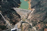
The Spring Creek Debris Dam is an earthfill dam
on Spring Creek, a tributary of the Sacramento River
, in Shasta County in the U.S. state
of California
. Completed in 1963, the dam, maintained by the U.S. Bureau of Reclamation, serves primarily to collect severe acid mine drainage
stemming from the Iron Mountain Mine
. The dam forms the Spring Creek Reservoir
, less than 1 miles (1.6 km) long. Spring Creek and South Fork Spring Creek flow into the reservoir from a 16 square miles (41.4 km²) watershed. The dam is directly upstream from the city of Keswick, California
and the Keswick Reservoir.
The operation is part of the Trinity River Division of the Central Valley Project
.
The primary purpose of the Spring Creek Dam was to collect acid mine drainage
from the old Iron Mountain Mine
, which was heavily polluting Spring Creek and its tributaries. The dam was built in response to the pollutants that were contaminating reservoirs on the Sacramento River, which was and still is the water supply of millions of Californians. Although the watershed is small in comparison to that of the Sacramento River, the stream is among the most polluted and acidic in the world.
The dam and reservoir, along with other treatment structures built at and below the mine, have successfully reduced the dry weather pollution of Spring Creek by up to ninety-five percent. Problems, though, still occur mainly in the form of large uncontrolled spills from the reservoir. Several concerns about the structural integrity and safety of the dam, both physically and biologically, arose in the 1990s. Emergency releases from Shasta Lake
, often in the value of thousands of acre feet of water, have occurred from time to time to dilute massive acid spills from the Spring Creek drainage.
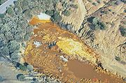
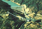 The Iron Mountain Mine, the most productive copper mine in California in at least one point along its history, operated along the banks of two Spring Creek tributaries, upstream from the current dam site, from 1879 to the 1960s. The mine extracted iron ore, silver
, gold
, copper sulfide
ore, and pyrite
from a rock formation dating to approximately 780,000 years ago. The potential of a mine at the site was discovered in 1860, when two men, surveyor
William Magee and settler Charles Camden, discovered an extensive iron ore deposit along one of the tributaries of Spring Creek. In 1879, silver was also discovered at the site, and the mine was begun. The ownership was transferred to Mountain Mines Ltd., a London
company, in 1894. At the very end of the 19th century, Iron Mountain Mine took blames for several fish kill
s in the Sacramento River
. Nevertheless, mining activity continued, and by 1928, 600 tons of ore were being extracted from the site per day.
The still continuing problem of Iron Mountain Mine runoff has once been described as:
and its afterbay (regulating downstream dam), Keswick Dam, in 1943 and 1950, respectively, severely impaired the capability of the Sacramento River to flush away pollutants from the mine. Acid mine drainage
flowed, unfettered, down Spring Creek directly into the Keswick Reservoir, depositing contaminated sediment and turning a portion of the water a rusty red shade. Previously, the water would have continued down the creek into the river, and flushed to the Pacific Ocean
. The pooling of the water, however, made it extremely difficult for the pollutants to be removed. From 1955 to 1962, open pit mining began on the site. At its peak, the mine discharged 5 tons of iron
, 650 pounds (294.8 kg) of copper
, and 1800 pounds (816.5 kg) of zinc
into the stream per day. By then, the water flowing down the drainage was so contaminated that it necessitated the construction of a holding dam, the Spring Creek Dam.
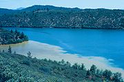 Spring Creek Dam was begun in 1961, when a company named Gibbons and Reed was awarded the contract. The clearing operations began in July of that same year, and the dam was officially dedicated by the Bureau of Reclamation on September 12, 1961. Construction of the dam began on October 20, 1961, with the placing of the dam embankment, which at least partially consists of acidic sediment dredged from Spring Creek.
Riprap
was laid on the upstream face of the dam beginning November 9 of that year. In 1962, a series of labor strikes impacted communities in the Central Valley, also affecting construction of the dam, which was temporarily halted on May 3 of that year. After work restarted on June 26, pervious core material for the dam was soon out of supply, so impervious material was used to complete the dam core.
Eventually, the Iron Mountain Mine closed, but pollution continued and still continues, and in 1983, the Iron Mountain Mine was listed on the National Priorities List
. The Iron Mountain Mine is known for having the most acidic naturally found water content on Earth, with samples having up to a −3.6 pH
value when tested in the early 1990s, which is roughly 100 times the acidity of battery acid.
However, this pH value is only found inside and near the mine, as the average pH of water entering the Spring Creek Reservoir is 4.12.
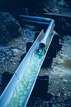 The Spring Creek Dam was later deemed "undersized" for the Spring Creek watershed, as the large flows of both natural drainage and acid mine drainage caused frequent uncontrollable spills at the dam. The spills contain many volatile components in acid mine drainage, which include the most acidic naturally occurring (i.e. not in a laboratory) water on Earth. Several alternatives were considered for remediating this problem:
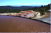 In 1985, it was found that water seepage into the foundations of the Spring Creek Dam could possibly cause its collapse. Shortly after the discovery, a controversy over the irregular spills of mine toxins from the dam began in the 1990s. Two years later, in March 1992, an uncontrolled, unexpected spill of acidic water rushed from the dam down Spring Creek. This spill heavily contaminated the Keswick Reservoir and threatened the water supply of Redding, California
. Despite the fact that the region was suffering from a drought, 77000 acre.ft of water were released from Shasta Lake
, which was only half full, to dilute the pollution. The loss of the water, which was badly needed by Central Valley agricultural users, was estimated at US$18 million.
A water treatment plant was built on a site named Minnesota Flats near the Iron Mountain Mine, using lime
to balance the pH of the acid mine drainage. Water is also diverted from Slickrock Creek to the treatment site. Altogether, over 95 percent of toxins in the water are removed by the treatment process. Roughly 8.5 miles (13.7 km) of specialized acid-resistant pipeline, with a cost of over US$1 million per mile, are included in the treatment process. Most water flowing directly from the mine has a pH level close to 1; the −3.2 pH mentioned earlier is only found in small amounts. Water is further diluted by natural flow in the tributaries and water diverted from nearby Clear Creek
, however, the acidic water still requires treatment.
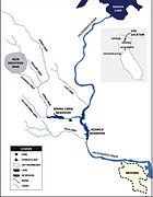 Spring Creek is a southeast-flowing, 9 miles (14.5 km) long tributary
of the Sacramento River
, receiving water from approximately 16 square miles (41.4 km²) of land. The creek begins in the Klamath Mountains
above the Sacramento River drainage, and flows in a generally south-east direction before turning south and sharply west into the Spring Creek Reservoir. From the reservoir, it continues due west until it empties directly into an arm of the Keswick Reservoir. The creek never actually runs by the mine. The acid mine drainage
found in the creek is actually carried in by two smaller tributaries, which are Boulder Creek and Slickrock Creek. The former stream runs southeast from the north side of Iron Mountain Mine
to Spring Creek, while the latter stream drains the south side of the mine and also flows southeast into Spring Creek. South Fork Spring Creek is a small tributary that flows west and north the Spring Creek Reservoir, but since its basin lies far from the mine, it receives no acid mine drainage. The inflow and outflow from the reservoir are highly erratic, ranging from 0 ft3 per second to roughly 225 ft3 per second in a particular 10-day period from March to April.
Flat Creek, a small southeast-flowing stream, rises in two forks and empties into the Sacramento River upstream of Spring Creek. The stream receives contaminated runoff from the Minnesota Flats Tailing Pile, but is not nearly as polluted or acidic as Spring Creek. Another stream, Rock Creek, rises in three forks and flows east to meet the Sacramento River downstream of Spring Creek and the Keswick Reservoir.
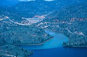 The Spring Creek Dam is 196 feet (59.7 m) high, 1110 feet (338.3 m) long along its crest, and 1040 feet (317 m) thick at its base. Its crest stands 816 feet (248.7 m) above sea level. The reservoir is 795 feet (242.3 m) above sea level at full pool and spillway crest level. When at full pool, the reservoir holds 5870 acre.ft of water with a depth of roughly 184 feet (56.1 m). One spillway
runs over the crest of the dam on the left bank of the canyon. The spillway is 25 feet (7.6 m) wide, able to accommodate a water flow of 5260 ft3 per second. The outlet works
of the dam are located at the base, and can accommodate a water flow of 660 ft3 per second. The Spring Creek Powerplant downstream of the dam generates up to 180,000 kilowatts.
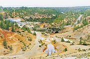 The Spring Creek Powerplant is located at the base of the Spring Creek Dam, and is actually supplied by flow from Whiskeytown Lake
. The lake, formed by Whiskeytown Dam, is on Clear Creek
, a drainage downstream along the Sacramento River from Spring Creek. Both streams run east into the river. The power plant was completed and began operations in 1964, with a capacity of 150,000 kW. The capacity was later upgraded to 180,000 kW. The plant is a peaking power plant
with two separate generators, generating power for operations and distributing excess power to the local power grid. Water from Whiskeytown Lake is diverted through the Spring Creek Tunnel, a conduit roughly 2.4 miles (3.9 km) long and 18.5 feet (5.6 m) in diameter.
The Bureau of Reclamation gives a detailed report on the specifications of the generating plant:
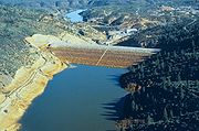 Spring Creek Reservoir
is the artificial lake
formed behind the dam. The reservoir is used mostly for flood control storage, and is rarely filled to its 5870 acre.ft capacity. During the dry season, water from Spring Creek pools in a small, stagnant pond retained behind the dam, depositing contaminated sediment and acidic mine waste in the reservoir space. When flows from the Shasta Dam
, upstream on the Sacramento River
, are sufficient to flush contaminated water away, water held in the reservoir is released through the outlet works into the Keswick Reservoir and the Sacramento River. Despite this operation strategy, the reservoir was eventually deemed inadequate for the watershed, and can be filled to capacity by a single heavy storm event. Uncontrollable spills frequently poured into the Sacramento River during floods, through the crest spillway of the dam, which lacks gates. As a result, numerous fish kill
s have occurred during these sudden releases of contaminants, a major one of which was in 1969. Due to this consistent acid pollution from the reservoir, most large fish spawn downstream of Red Bluff Diversion Dam, a dam also on the Sacramento River near Red Bluff, California
.
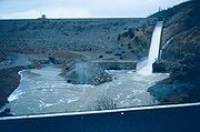 The Spring Creek Dam is able to release up to 5920 ft3 of water per second from the Spring Creek Reservoir, through a crest spillway and outlet works. The spillway begins on the left bank of the dam at elevation 795 feet (242.3 m), and drops roughly 184 feet (56.1 m) in vertical distance down the face of the dam into a stilling basin, before flowing into Spring Creek and into the Sacramento River. It is roughly 25 feet (7.6 m) wide and can carry 5260 ft3 per second. The outlet works tunnel through the dam from an elevation much lower than that of the spillway; the conduit terminates at a culvert
exit, a design commonly seen on storm drain
s but rarely seen on dams, at the base of the dam. The maximum capacity of the outlet works is 660 ft3 per second.
Dam
A dam is a barrier that impounds water or underground streams. Dams generally serve the primary purpose of retaining water, while other structures such as floodgates or levees are used to manage or prevent water flow into specific land regions. Hydropower and pumped-storage hydroelectricity are...
on Spring Creek, a tributary of the Sacramento River
Sacramento River
The Sacramento River is an important watercourse of Northern and Central California in the United States. The largest river in California, it rises on the eastern slopes of the Klamath Mountains, and after a journey south of over , empties into Suisun Bay, an arm of the San Francisco Bay, and...
, in Shasta County in the U.S. state
U.S. state
A U.S. state is any one of the 50 federated states of the United States of America that share sovereignty with the federal government. Because of this shared sovereignty, an American is a citizen both of the federal entity and of his or her state of domicile. Four states use the official title of...
of California
California
California is a state located on the West Coast of the United States. It is by far the most populous U.S. state, and the third-largest by land area...
. Completed in 1963, the dam, maintained by the U.S. Bureau of Reclamation, serves primarily to collect severe acid mine drainage
Acid mine drainage
Acid mine drainage , or acid rock drainage , refers to the outflow of acidic water from metal mines or coal mines. However, other areas where the earth has been disturbed may also contribute acid rock drainage to the environment...
stemming from the Iron Mountain Mine
Iron Mountain Mine
Iron Mountain Mine, also known as the Richmond Mine at Iron Mountain, is a mine near Redding in Northern California. Geologically classified as a "massive sulfide ore deposit", the site was mined for iron, silver, gold, copper, zinc, and pyrite intermittently from the 1860s until 1963...
. The dam forms the Spring Creek Reservoir
Spring Creek Reservoir (California)
The Spring Creek Reservoir is the artificial lake created by the construction of the Spring Creek Dam across Spring Creek in the Shasta-Trinity National Forest of Shasta County, California, adjacent to Keswick....
, less than 1 miles (1.6 km) long. Spring Creek and South Fork Spring Creek flow into the reservoir from a 16 square miles (41.4 km²) watershed. The dam is directly upstream from the city of Keswick, California
Keswick, California
Keswick is a census-designated place in Shasta County, California. Keswick sits at an elevation of . The 2010 United States census reported Keswick's population was 451.-Geography:...
and the Keswick Reservoir.
The operation is part of the Trinity River Division of the Central Valley Project
Central Valley Project
The Central Valley Project is a Bureau of Reclamation federal water project in the U.S. state of California. It was devised in 1933 in order to provide irrigation and municipal water to much of California's Central Valley—by regulating and storing water in reservoirs in the water-rich northern...
.
The primary purpose of the Spring Creek Dam was to collect acid mine drainage
Acid mine drainage
Acid mine drainage , or acid rock drainage , refers to the outflow of acidic water from metal mines or coal mines. However, other areas where the earth has been disturbed may also contribute acid rock drainage to the environment...
from the old Iron Mountain Mine
Iron Mountain Mine
Iron Mountain Mine, also known as the Richmond Mine at Iron Mountain, is a mine near Redding in Northern California. Geologically classified as a "massive sulfide ore deposit", the site was mined for iron, silver, gold, copper, zinc, and pyrite intermittently from the 1860s until 1963...
, which was heavily polluting Spring Creek and its tributaries. The dam was built in response to the pollutants that were contaminating reservoirs on the Sacramento River, which was and still is the water supply of millions of Californians. Although the watershed is small in comparison to that of the Sacramento River, the stream is among the most polluted and acidic in the world.
The dam and reservoir, along with other treatment structures built at and below the mine, have successfully reduced the dry weather pollution of Spring Creek by up to ninety-five percent. Problems, though, still occur mainly in the form of large uncontrolled spills from the reservoir. Several concerns about the structural integrity and safety of the dam, both physically and biologically, arose in the 1990s. Emergency releases from Shasta Lake
Shasta Lake
Shasta Lake, also called Lake Shasta, is an artificial lake created by the construction of Shasta Dam across the Sacramento River in the Shasta-Trinity National Forest of Shasta County, California...
, often in the value of thousands of acre feet of water, have occurred from time to time to dilute massive acid spills from the Spring Creek drainage.
Mining


Silver
Silver is a metallic chemical element with the chemical symbol Ag and atomic number 47. A soft, white, lustrous transition metal, it has the highest electrical conductivity of any element and the highest thermal conductivity of any metal...
, gold
Gold
Gold is a chemical element with the symbol Au and an atomic number of 79. Gold is a dense, soft, shiny, malleable and ductile metal. Pure gold has a bright yellow color and luster traditionally considered attractive, which it maintains without oxidizing in air or water. Chemically, gold is a...
, copper sulfide
Copper sulfide
Copper sulfides describe a family of chemical compounds and minerals with the formula CuxSy. Both minerals and synthetic materials comprise these compounds. Some copper sulfides are economically important ores....
ore, and pyrite
Pyrite
The mineral pyrite, or iron pyrite, is an iron sulfide with the formula FeS2. This mineral's metallic luster and pale-to-normal, brass-yellow hue have earned it the nickname fool's gold because of its resemblance to gold...
from a rock formation dating to approximately 780,000 years ago. The potential of a mine at the site was discovered in 1860, when two men, surveyor
Surveying
See Also: Public Land Survey SystemSurveying or land surveying is the technique, profession, and science of accurately determining the terrestrial or three-dimensional position of points and the distances and angles between them...
William Magee and settler Charles Camden, discovered an extensive iron ore deposit along one of the tributaries of Spring Creek. In 1879, silver was also discovered at the site, and the mine was begun. The ownership was transferred to Mountain Mines Ltd., a London
London
London is the capital city of :England and the :United Kingdom, the largest metropolitan area in the United Kingdom, and the largest urban zone in the European Union by most measures. Located on the River Thames, London has been a major settlement for two millennia, its history going back to its...
company, in 1894. At the very end of the 19th century, Iron Mountain Mine took blames for several fish kill
Fish kill
The term fish kill, known also as fish die-off and as fish mortality, is a localized die-off of fish populations which may also be associated with more generalised mortality of aquatic life...
s in the Sacramento River
Sacramento River
The Sacramento River is an important watercourse of Northern and Central California in the United States. The largest river in California, it rises on the eastern slopes of the Klamath Mountains, and after a journey south of over , empties into Suisun Bay, an arm of the San Francisco Bay, and...
. Nevertheless, mining activity continued, and by 1928, 600 tons of ore were being extracted from the site per day.
The still continuing problem of Iron Mountain Mine runoff has once been described as:
Events prompting construction
The construction of Shasta DamShasta Dam
Shasta Dam is an arch dam across the Sacramento River in the northern part of the U.S. state of California, at the north end of the Sacramento Valley. The dam mainly serves long-term water storage and flood control in its reservoir, Shasta Lake, and also generates hydroelectric power...
and its afterbay (regulating downstream dam), Keswick Dam, in 1943 and 1950, respectively, severely impaired the capability of the Sacramento River to flush away pollutants from the mine. Acid mine drainage
Acid mine drainage
Acid mine drainage , or acid rock drainage , refers to the outflow of acidic water from metal mines or coal mines. However, other areas where the earth has been disturbed may also contribute acid rock drainage to the environment...
flowed, unfettered, down Spring Creek directly into the Keswick Reservoir, depositing contaminated sediment and turning a portion of the water a rusty red shade. Previously, the water would have continued down the creek into the river, and flushed to the Pacific Ocean
Pacific Ocean
The Pacific Ocean is the largest of the Earth's oceanic divisions. It extends from the Arctic in the north to the Southern Ocean in the south, bounded by Asia and Australia in the west, and the Americas in the east.At 165.2 million square kilometres in area, this largest division of the World...
. The pooling of the water, however, made it extremely difficult for the pollutants to be removed. From 1955 to 1962, open pit mining began on the site. At its peak, the mine discharged 5 tons of iron
Iron
Iron is a chemical element with the symbol Fe and atomic number 26. It is a metal in the first transition series. It is the most common element forming the planet Earth as a whole, forming much of Earth's outer and inner core. It is the fourth most common element in the Earth's crust...
, 650 pounds (294.8 kg) of copper
Copper
Copper is a chemical element with the symbol Cu and atomic number 29. It is a ductile metal with very high thermal and electrical conductivity. Pure copper is soft and malleable; an exposed surface has a reddish-orange tarnish...
, and 1800 pounds (816.5 kg) of zinc
Zinc
Zinc , or spelter , is a metallic chemical element; it has the symbol Zn and atomic number 30. It is the first element in group 12 of the periodic table. Zinc is, in some respects, chemically similar to magnesium, because its ion is of similar size and its only common oxidation state is +2...
into the stream per day. By then, the water flowing down the drainage was so contaminated that it necessitated the construction of a holding dam, the Spring Creek Dam.

Riprap
Riprap
Riprap — also known as rip rap, rubble, shot rock or rock armour or "Rip-rap" — is rock or other material used to armor shorelines, streambeds, bridge abutments, pilings and other shoreline structures against scour, water or ice erosion.It is made from a variety of rock types, commonly granite or...
was laid on the upstream face of the dam beginning November 9 of that year. In 1962, a series of labor strikes impacted communities in the Central Valley, also affecting construction of the dam, which was temporarily halted on May 3 of that year. After work restarted on June 26, pervious core material for the dam was soon out of supply, so impervious material was used to complete the dam core.
Eventually, the Iron Mountain Mine closed, but pollution continued and still continues, and in 1983, the Iron Mountain Mine was listed on the National Priorities List
National Priorities List
The National Priorities List is the list of hazardous waste sites in the United States eligible for long-term remedial action financed under the federal Superfund program. Environmental Protection Agency regulations outline a formal process for assessing hazardous waste sites and placing them on...
. The Iron Mountain Mine is known for having the most acidic naturally found water content on Earth, with samples having up to a −3.6 pH
PH
In chemistry, pH is a measure of the acidity or basicity of an aqueous solution. Pure water is said to be neutral, with a pH close to 7.0 at . Solutions with a pH less than 7 are said to be acidic and solutions with a pH greater than 7 are basic or alkaline...
value when tested in the early 1990s, which is roughly 100 times the acidity of battery acid.
However, this pH value is only found inside and near the mine, as the average pH of water entering the Spring Creek Reservoir is 4.12.
Storage expansion

- Enlarge the Spring Creek Dam to create a reservoir three times its original size: This plan was considered, but never built, as the cost of it was estimated at .
- Partial capping (covering) of the site: The ore body in Iron Mountain was determined to be shallow, so this alternative was considered. However, the recurring high occurrence of fractures in the mountain made this inefficient, so it was also never implemented.
- Construction of dams upstream: This proposal called for several dams upstream that would "reduce the watershed by 40 percent", including a dam on Slickrock Creek, a branch of Spring Creek. This plan was implemented, removing the need for the dam enlargement.
- Waste rock removal: Rock extracted from the mine was removed from tailings piles and disposed of in a compacted cell. In Boulder Creek, another tributary of Spring Creek, the acidity level has lowered slightly.
Recent history

Redding, California
Redding is a city in far-Northern California. It is the county seat of Shasta County, California, USA. With a population of 89,861, according to the 2010 Census...
. Despite the fact that the region was suffering from a drought, 77000 acre.ft of water were released from Shasta Lake
Shasta Lake
Shasta Lake, also called Lake Shasta, is an artificial lake created by the construction of Shasta Dam across the Sacramento River in the Shasta-Trinity National Forest of Shasta County, California...
, which was only half full, to dilute the pollution. The loss of the water, which was badly needed by Central Valley agricultural users, was estimated at US$18 million.
A water treatment plant was built on a site named Minnesota Flats near the Iron Mountain Mine, using lime
Calcium oxide
Calcium oxide , commonly known as quicklime or burnt lime, is a widely used chemical compound. It is a white, caustic, alkaline crystalline solid at room temperature....
to balance the pH of the acid mine drainage. Water is also diverted from Slickrock Creek to the treatment site. Altogether, over 95 percent of toxins in the water are removed by the treatment process. Roughly 8.5 miles (13.7 km) of specialized acid-resistant pipeline, with a cost of over US$1 million per mile, are included in the treatment process. Most water flowing directly from the mine has a pH level close to 1; the −3.2 pH mentioned earlier is only found in small amounts. Water is further diluted by natural flow in the tributaries and water diverted from nearby Clear Creek
Clear Creek (California)
Clear Creek is a tributary of the Sacramento River. It is long and is the first major tributary downstream of the Shasta Dam. The creek originates between Shasta Lake and Trinity Lake and drains into Whiskeytown Lake, which is formed by Whiskeytown Dam. Past the lake, the creek continues south...
, however, the acidic water still requires treatment.
Hydrography

Tributary
A tributary or affluent is a stream or river that flows into a main stem river or a lake. A tributary does not flow directly into a sea or ocean...
of the Sacramento River
Sacramento River
The Sacramento River is an important watercourse of Northern and Central California in the United States. The largest river in California, it rises on the eastern slopes of the Klamath Mountains, and after a journey south of over , empties into Suisun Bay, an arm of the San Francisco Bay, and...
, receiving water from approximately 16 square miles (41.4 km²) of land. The creek begins in the Klamath Mountains
Klamath Mountains
The Klamath Mountains, which include the Siskiyou, Marble, Scott, Trinity, Trinity Alps, Salmon, and northern Yolla-Bolly Mountains, are a rugged lightly populated mountain range in northwest California and southwest Oregon in the United States...
above the Sacramento River drainage, and flows in a generally south-east direction before turning south and sharply west into the Spring Creek Reservoir. From the reservoir, it continues due west until it empties directly into an arm of the Keswick Reservoir. The creek never actually runs by the mine. The acid mine drainage
Acid mine drainage
Acid mine drainage , or acid rock drainage , refers to the outflow of acidic water from metal mines or coal mines. However, other areas where the earth has been disturbed may also contribute acid rock drainage to the environment...
found in the creek is actually carried in by two smaller tributaries, which are Boulder Creek and Slickrock Creek. The former stream runs southeast from the north side of Iron Mountain Mine
Iron Mountain Mine
Iron Mountain Mine, also known as the Richmond Mine at Iron Mountain, is a mine near Redding in Northern California. Geologically classified as a "massive sulfide ore deposit", the site was mined for iron, silver, gold, copper, zinc, and pyrite intermittently from the 1860s until 1963...
to Spring Creek, while the latter stream drains the south side of the mine and also flows southeast into Spring Creek. South Fork Spring Creek is a small tributary that flows west and north the Spring Creek Reservoir, but since its basin lies far from the mine, it receives no acid mine drainage. The inflow and outflow from the reservoir are highly erratic, ranging from 0 ft3 per second to roughly 225 ft3 per second in a particular 10-day period from March to April.
Flat Creek, a small southeast-flowing stream, rises in two forks and empties into the Sacramento River upstream of Spring Creek. The stream receives contaminated runoff from the Minnesota Flats Tailing Pile, but is not nearly as polluted or acidic as Spring Creek. Another stream, Rock Creek, rises in three forks and flows east to meet the Sacramento River downstream of Spring Creek and the Keswick Reservoir.
Dimensions and operations

Spillway
A spillway is a structure used to provide the controlled release of flows from a dam or levee into a downstream area, typically being the river that was dammed. In the UK they may be known as overflow channels. Spillways release floods so that the water does not overtop and damage or even destroy...
runs over the crest of the dam on the left bank of the canyon. The spillway is 25 feet (7.6 m) wide, able to accommodate a water flow of 5260 ft3 per second. The outlet works
Outlet works
A set of outlet works is a device used to release and regulate water flow from a dam. Such devices usually consist of one or more pipes or tunnels through the embankment of the dam, directing water usually under high pressure to the river downstream...
of the dam are located at the base, and can accommodate a water flow of 660 ft3 per second. The Spring Creek Powerplant downstream of the dam generates up to 180,000 kilowatts.
Spring Creek Powerplant

Whiskeytown Lake
Whiskeytown Lake is a lake in Shasta County in northwestern California, about west of Redding. The lake is in the Whiskeytown Unit of the Whiskeytown-Shasta-Trinity National Recreation Area. It has a capacity of and is formed by Whiskeytown Dam on Clear Creek...
. The lake, formed by Whiskeytown Dam, is on Clear Creek
Clear Creek (California)
Clear Creek is a tributary of the Sacramento River. It is long and is the first major tributary downstream of the Shasta Dam. The creek originates between Shasta Lake and Trinity Lake and drains into Whiskeytown Lake, which is formed by Whiskeytown Dam. Past the lake, the creek continues south...
, a drainage downstream along the Sacramento River from Spring Creek. Both streams run east into the river. The power plant was completed and began operations in 1964, with a capacity of 150,000 kW. The capacity was later upgraded to 180,000 kW. The plant is a peaking power plant
Peaking power plant
Peaking power plants, also known as peaker plants, and occasionally just "peakers," are power plants that generally run only when there is a high demand, known as peak demand, for electricity.-Peak hours:...
with two separate generators, generating power for operations and distributing excess power to the local power grid. Water from Whiskeytown Lake is diverted through the Spring Creek Tunnel, a conduit roughly 2.4 miles (3.9 km) long and 18.5 feet (5.6 m) in diameter.
The Bureau of Reclamation gives a detailed report on the specifications of the generating plant:
Spring Creek Reservoir

Spring Creek Reservoir (California)
The Spring Creek Reservoir is the artificial lake created by the construction of the Spring Creek Dam across Spring Creek in the Shasta-Trinity National Forest of Shasta County, California, adjacent to Keswick....
is the artificial lake
Lake
A lake is a body of relatively still fresh or salt water of considerable size, localized in a basin, that is surrounded by land. Lakes are inland and not part of the ocean and therefore are distinct from lagoons, and are larger and deeper than ponds. Lakes can be contrasted with rivers or streams,...
formed behind the dam. The reservoir is used mostly for flood control storage, and is rarely filled to its 5870 acre.ft capacity. During the dry season, water from Spring Creek pools in a small, stagnant pond retained behind the dam, depositing contaminated sediment and acidic mine waste in the reservoir space. When flows from the Shasta Dam
Shasta Dam
Shasta Dam is an arch dam across the Sacramento River in the northern part of the U.S. state of California, at the north end of the Sacramento Valley. The dam mainly serves long-term water storage and flood control in its reservoir, Shasta Lake, and also generates hydroelectric power...
, upstream on the Sacramento River
Sacramento River
The Sacramento River is an important watercourse of Northern and Central California in the United States. The largest river in California, it rises on the eastern slopes of the Klamath Mountains, and after a journey south of over , empties into Suisun Bay, an arm of the San Francisco Bay, and...
, are sufficient to flush contaminated water away, water held in the reservoir is released through the outlet works into the Keswick Reservoir and the Sacramento River. Despite this operation strategy, the reservoir was eventually deemed inadequate for the watershed, and can be filled to capacity by a single heavy storm event. Uncontrollable spills frequently poured into the Sacramento River during floods, through the crest spillway of the dam, which lacks gates. As a result, numerous fish kill
Fish kill
The term fish kill, known also as fish die-off and as fish mortality, is a localized die-off of fish populations which may also be associated with more generalised mortality of aquatic life...
s have occurred during these sudden releases of contaminants, a major one of which was in 1969. Due to this consistent acid pollution from the reservoir, most large fish spawn downstream of Red Bluff Diversion Dam, a dam also on the Sacramento River near Red Bluff, California
Red Bluff, California
Red Bluff is a city in and the county seat of Tehama County, California, United States. The population was 14,076 at the 2010 census, up from 13,147 at the 2000 census....
.
Spillway and outlet works

Culvert
A culvert is a device used to channel water. It may be used to allow water to pass underneath a road, railway, or embankment. Culverts can be made of many different materials; steel, polyvinyl chloride and concrete are the most common...
exit, a design commonly seen on storm drain
Storm drain
A storm drain, storm sewer , stormwater drain or drainage well system or simply a drain or drain system is designed to drain excess rain and ground water from paved streets, parking lots, sidewalks, and roofs. Storm drains vary in design from small residential dry wells to large municipal systems...
s but rarely seen on dams, at the base of the dam. The maximum capacity of the outlet works is 660 ft3 per second.
Further reading
- Suter, Glenn W. Aquatic toxicology and environmental fate, page 196. ASTM International, 1989
- West's federal supplement, First Series, pages 1253 and 1261. University of CaliforniaUniversity of CaliforniaThe University of California is a public university system in the U.S. state of California. Under the California Master Plan for Higher Education, the University of California is a part of the state's three-tier public higher education system, which also includes the California State University...
, 1998. - Journal, pages 988, 991-993. American Water Works AssociationAmerican Water Works AssociationAmerican Water Works Association was established as an international non-profit professional organization dedicated to the improvement of water quality and supply. Founded in 1881, it claims a membership of around 56,000 members worldwide as of 2010.AWWA has become the largest organization of...
, 1965. - Hinchiff, Dave. Performance Parameters for Spring Creek Debris Dam. Bureau of Reclamation, 1997.
- Vallero, Daniel A. Paradigms Lost, pages 342-344. Butterworth-Heinemann, 2005.
- International Association for Hydraulic Research. Environmental and coastal hydraulics, pages 21–24 (section Spring Creek Dam). American Society of Civil EngineersAmerican Society of Civil EngineersThe American Society of Civil Engineers is a professional body founded in 1852 to represent members of the civil engineering profession worldwide. It is the oldest national engineering society in the United States. ASCE's vision is to have engineers positioned as global leaders who strive toward...
, 1997.
External links
- NOAA photo gallery of Spring Creek, Iron Mountain Mine, and Spring Creek Dam
- EPA Iron Mountain Mine Case Study
- Acid Runoff from Iron Mountain Mine Superfund Site
- Drought Impacts on Fish, Wildlife and Recreation in Northern California (Spring Creek Dam Section)
- Iron Mountain Mine and Spring Creek Watershed Photo Tour
- Spring Creek Powerplant Performance Data
- History of the Trinity River Division

