

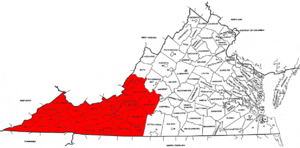
Southwest Virginia
Encyclopedia
Virginia
The Commonwealth of Virginia , is a U.S. state on the Atlantic Coast of the Southern United States. Virginia is nicknamed the "Old Dominion" and sometimes the "Mother of Presidents" after the eight U.S. presidents born there...
in the westernmost part of the commonwealth
Commonwealth (United States)
Four of the constituent states of the United States officially designate themselves Commonwealths: Kentucky, Massachusetts, Pennsylvania and Virginia....
. Southwest Virginia has been defined alternatively as all Virginia counties on the Appalachian Plateau
Appalachian Plateau
The Appalachian Plateau is the western part of the Appalachian mountains, stretching from New York and Alabama. The plateau is a second level United States physiographic region....
, all Virginia counties west of the Eastern Continental Divide
Eastern Continental Divide
The Eastern Continental Divide, in conjunction with other continental divides of North America, demarcates two watersheds of the Atlantic Ocean: the Gulf of Mexico watershed and the Atlantic Seaboard watershed. Prior to 1760, the divide represented the boundary between British and French colonial...
, or at its greatest expanse, as far east as Blacksburg
Blacksburg, Virginia
Blacksburg is an incorporated town located in Montgomery County, Virginia, United States, with a population of 42,620 at the 2010 census. Blacksburg, Christiansburg, and Radford are the three principal jurisdictions of the Blacksburg-Christiansburg-Radford Metropolitan Statistical Area which...
and Roanoke
Roanoke, Virginia
Roanoke is an independent city in the Mid-Atlantic U.S. state of Virginia and is the tenth-largest city in the Commonwealth. It is located in the Roanoke Valley of the Roanoke Region of Virginia. The population within the city limits was 97,032 as of 2010...
. Another geographic categorization of the region places it as those counties within the Tennessee River
Tennessee River
The Tennessee River is the largest tributary of the Ohio River. It is approximately 652 miles long and is located in the southeastern United States in the Tennessee Valley. The river was once popularly known as the Cherokee River, among other names...
watershed
Drainage basin
A drainage basin is an extent or an area of land where surface water from rain and melting snow or ice converges to a single point, usually the exit of the basin, where the waters join another waterbody, such as a river, lake, reservoir, estuary, wetland, sea, or ocean...
. Regardless of how borders are drawn, Southwest Virginia differs from the rest of the commonwealth in that its culture is more closely associated with Appalachia
Appalachia
Appalachia is a term used to describe a cultural region in the eastern United States that stretches from the Southern Tier of New York state to northern Alabama, Mississippi, and Georgia. While the Appalachian Mountains stretch from Belle Isle in Canada to Cheaha Mountain in the U.S...
than the other regions of Virginia. Historically, the region has been and remains rural, but in the 20th century, coal mining
Coal mining
The goal of coal mining is to obtain coal from the ground. Coal is valued for its energy content, and since the 1880s has been widely used to generate electricity. Steel and cement industries use coal as a fuel for extraction of iron from iron ore and for cement production. In the United States,...
became an important part of its economy up until the second half of the century.
Counties that have been included in the definition of Southwest Virginia include: Alleghany County
Alleghany County, Virginia
As of the census of 2000, there were 12,926 people, 5,149 households, and 3,866 families residing in the county. The population density was 29 people per square mile . There were 5,812 housing units at an average density of 13 per square mile...
, Bedford County
Bedford County, Virginia
As of the census of 2000, there were 60,371 people, 23,838 households, and 18,164 families residing in the county. The population density was 80 people per square mile . There were 26,841 housing units at an average density of 36 per square mile...
, Bland County
Bland County, Virginia
As of the census of 2000, there were 6,871 people, 2,568 households, and 1,908 families residing in the county. The population density was 19 people per square mile . There were 3,161 housing units at an average density of 9 per square mile...
, Botetourt County
Botetourt County, Virginia
As of the census of 2000, there were 30,496 people, 11,700 households, and 9,114 families residing in the county. The population density was 56 people per square mile . There were 12,571 housing units at an average density of 23 per square mile...
, Buchanan County
Buchanan County, Virginia
As of the census of 2000, there were 26,978 people, 10,464 households, and 7,900 families residing in the county. The population density was 54 people per square mile . There were 11,887 housing units at an average density of 24 per square mile...
, Carroll County
Carroll County, Virginia
As of the census of 2000, there were 29,245 people, 12,186 households, and 8,786 families residing in the county. The population density was 61 people per square mile . There were 14,680 housing units at an average density of 31 per square mile...
, Craig County
Craig County, Virginia
As of the census of 2000, there were 5,091 people, 2,060 households, and 1,507 families residing in the county. The population density was 15 people per square mile . There were 2,554 housing units at an average density of 8 per square mile...
, Dickenson County
Dickenson County, Virginia
As of the census of 2000, there were 16,395 people, 6,732 households, and 4,887 families residing in the county. The population density was 49 people per square mile . There were 7,684 housing units at an average density of 23 per square mile...
, Floyd County
Floyd County, Virginia
As of the census of 2000, there were 13,874 people, 5,791 households, and 4,157 families residing in the county. The population density was 36 people per square mile . There were 6,763 housing units at an average density of 18 per square mile...
, Franklin County
Franklin County, Virginia
As of the census of 2000, there were 47,286 people, 18,963 households, and 13,918 families residing in the county. The population density was 68 people per square mile . There were 22,717 housing units at an average density of 33 per square mile...
, Giles County
Giles County, Virginia
As of the census of 2000, there were 16,657 people, 6,994 households, and 4,888 families residing in the county. The population density was 47 people per square mile . There were 7,732 housing units at an average density of 22 per square mile...
, Grayson County
Grayson County, Virginia
As of the census of 2000, there were 17,917 people, 7,259 households, and 5,088 families residing in the county. The population density was 40 people per square mile . There were 9,123 housing units at an average density of 21 per square mile...
, Henry County
Henry County, Virginia
As of the census of 2000, there were 57,930 people, 23,910 households, and 16,952 families residing in the county. The population density was 152 people per square mile . There were 25,921 housing units at an average density of 68 per square mile...
, Lee County
Lee County, Virginia
According to the census 2009 estimates, there were 25001 people, 11,587 households, and 6,852 families residing in the county. The population density was 54 people per square mile . There were 11,587 housing units at an average density of 25 per square mile...
, Montgomery County
Montgomery County, Virginia
As of the census of 2000, there were 83,629 people, 30,997 households, and 17,203 families residing in the county. The population density was 215 people per square mile . There were 32,527 housing units at an average density of 84 per square mile...
, Patrick County
Patrick County, Virginia
Patrick County is a county located in the Commonwealth of Virginia. As of 2010, the population was 18,490. Its county seat is Stuart. It is located within both the rolling hills and valleys of the Piedmont Region of Virginia and mountainous Southwest Virginia....
, Pulaski County
Pulaski County, Virginia
As of the census of 2000, there were 35,127 people, 14,643 households, and 10,147 families residing in the county. The population density was 110 people per square mile . There were 16,325 housing units at an average density of 51 per square mile...
, Roanoke County
Roanoke County, Virginia
Roanoke County is a county located in the U.S. state of the Commonwealth of Virginia. It is part of the Roanoke Metropolitan Statistical Area and located within the Roanoke Region of Virginia. As of the 2000 census, the population was 85,778. As of 2010, the population was 92,376...
, Rockbridge County
Rockbridge County, Virginia
As of the census of 2000, there were 20,808 people, 8,486 households, and 6,075 families residing in the county. The population density was 35 people per square mile . There were 9,550 housing units at an average density of 16 per square mile...
, Russell County
Russell County, Virginia
As of the census of 2000, there were 30,308 people, 11,789 households, and 8,818 families residing in the county. The population density was 64 people per square mile . There were 13,191 housing units at an average density of 28 per square mile...
, Scott County
Scott County, Virginia
As of the census of 2000, there were 23,403 people, 9,795 households, and 7,023 families residing in the county. The population density was 44 people per square mile . There were 11,355 housing units at an average density of 21 per square mile...
, Smyth County
Smyth County, Virginia
As of the census of 2000, there were 33,081 people, 13,493 households, and 9,607 families residing in the county. The population density was 73 people per square mile . There were 15,111 housing units at an average density of 33 per square mile...
, Tazewell County
Tazewell County, Virginia
As of the census of 2000, there were 44,598 people, 18,277 households and 13,232 families residing in the county. The population density was 86 people per square mile . There were 20,390 housing units at an average density of 39 per square mile...
, Washington County
Washington County, Virginia
As of the census of 2000, there were 51,103 people, 21,056 households, and 14,949 families residing in the county. The population density was 91 people per square mile . There were 22,985 housing units at an average density of 41 per square mile...
, Wise County
Wise County, Virginia
Wise County is a county located in the U.S. state of Virginia. In 1856, the county was formed from land taken from Lee, Scott, and Russell Counties. It was named after Henry A. Wise, who was the Governor of Virginia at the time. As of 2010, the population was 41,452, making it the largest...
, and Wythe County
Wythe County, Virginia
As of the census of 2000, there were 27,599 people, 11,511 households, and 8,103 families residing in the county. The population density was 60 people per square mile . There were 12,744 housing units at an average density of 28 per square mile...
.
Unlike other states in the U.S., Virginia draws a sharp distinction between cities and counties. Under state law, all municipalities incorporated as cities are independent
Independent city
An independent city is a city that does not form part of another general-purpose local government entity. These type of cities should not be confused with city-states , which are fully sovereign cities that are not part of any other sovereign state.-Historical precursors:In the Holy Roman Empire,...
of any county. With that in mind, cities that have been included in the definition of Southwest Virginia are Bedford
Bedford, Virginia
Bedford is an independent city located within the confines of Bedford County in the U.S. state of Virginia. It serves as the county seat of Bedford County. As of 2010, the city had a total population of 6,222. The Bureau of Economic Analysis combines the city of Bedford with surrounding Bedford...
, Bristol
Bristol, Virginia
Bristol is an independent city in Virginia, United States, bounded by Washington County, Virginia, Bristol, Tennessee, and Sullivan County, Tennessee....
, Buena Vista
Buena Vista, Virginia
Buena Vista is an independent city located within the confines of Rockbridge County, Virginia. The population was 6,650 in 2010. The Bureau of Economic Analysis combines the city of Buena Vista with Rockbridge county for statistical purposes.-Geography:Buena Vista is located at...
, Covington
Covington, Virginia
Covington is an independent city in the U.S. state of Virginia, located at the confluence of Jackson River and Dunlap Creek. It is in Alleghany County where it is also the county seat. The population was 5,961 in 2010. The Bureau of Economic Analysis combines the city of Covington with Alleghany...
, Galax
Galax, Virginia
Galax is an independent city in the southwestern part of the Commonwealth of Virginia. It is bounded to the northeast by Carroll County and to the southwest by Grayson County. The population was 7,042 as of 2010...
, Lexington
Lexington, Virginia
Lexington is an independent city within the confines of Rockbridge County in the Commonwealth of Virginia. The population was 7,042 in 2010. Lexington is about 55 minutes east of the West Virginia border and is about 50 miles north of Roanoke, Virginia. It was first settled in 1777.It is home to...
, Martinsville
Martinsville, Virginia
Martinsville is an independent city which is surrounded by Henry County, Virginia, United States. The population was 13,821 in 2010. The Bureau of Economic Analysis combines the city of Martinsville with Henry County for statistical purposes...
, Norton
Norton, Virginia
Norton is an independent city within the confines of Wise County in the Commonwealth of Virginia. As of the 2010 Census, the city population was 3,958, making it the smallest city in the state by population...
, Radford
Radford, Virginia
Radford is a city in Virginia, United States. The population was 16,408 in 2010. For statistical purposes, the Bureau of Economic Analysis combines the city of Radford with neighboring Montgomery County, including the towns of Blacksburg and Christiansburg, calling the combination the...
, Roanoke
Roanoke, Virginia
Roanoke is an independent city in the Mid-Atlantic U.S. state of Virginia and is the tenth-largest city in the Commonwealth. It is located in the Roanoke Valley of the Roanoke Region of Virginia. The population within the city limits was 97,032 as of 2010...
, and Salem
Salem, Virginia
Salem is an independent city in Virginia, USA, bordered by the city of Roanoke to the east but otherwise adjacent to Roanoke County. It is part of the Roanoke Metropolitan Statistical Area. The population was 24,802 according to 2010 U.S. Census...
.
History
Southwest Virginia was among the last parts of the state to be settled by Europeans, in a flow of migrations that consisted mainly of the EnglishEnglish people
The English are a nation and ethnic group native to England, who speak English. The English identity is of early mediaeval origin, when they were known in Old English as the Anglecynn. England is now a country of the United Kingdom, and the majority of English people in England are British Citizens...
, Germans
Germans
The Germans are a Germanic ethnic group native to Central Europe. The English term Germans has referred to the German-speaking population of the Holy Roman Empire since the Late Middle Ages....
, and the Scots-Irish. A major route of migration to the region was the Great Wagon Road
Great Wagon Road
The Great Wagon Road was a colonial American improved trail transiting the Great Appalachian Valley from Pennsylvania to North Carolina, and from there to Georgia....
through the Great Appalachian Valley
Great Appalachian Valley
The Great Valley, also called the Great Appalachian Valley or Great Valley Region, is one of the major landform features of eastern North America. It is a gigantic trough — a chain of valley lowlands — and the central feature of the Appalachian Mountain system...
. At present-day Roanoke there was an important fork in the wagon road, with one branch passing through the Blue Ridge and into the Piedmont
Piedmont (United States)
The Piedmont is a plateau region located in the eastern United States between the Atlantic Coastal Plain and the main Appalachian Mountains, stretching from New Jersey in the north to central Alabama in the south. The Piedmont province is a physiographic province of the larger Appalachian division...
region, the other branch, called the Wilderness Road
Wilderness Road
The Wilderness Road was the principal route used by settlers for more than fifty years to reach Kentucky from the East. In 1775, Daniel Boone blazed a trail for the Transylvania Company from Fort Chiswell in Virginia through the Cumberland Gap into central Kentucky. It was later lengthened,...
continuing southwest to Tennessee and Kentucky. Much of the area was formally protected by a series of forts constructed around the time of Lord Dunmore's War, some of which later became the seats of future counties. Many of the present day counties were formed from larger counties which were broken up as the populations in the region continued to grow. Southwest Virginia is also the result of parts of Virginia which broke off or revolted, such as Kentucky
Kentucky
The Commonwealth of Kentucky is a state located in the East Central United States of America. As classified by the United States Census Bureau, Kentucky is a Southern state, more specifically in the East South Central region. Kentucky is one of four U.S. states constituted as a commonwealth...
and West Virginia
West Virginia
West Virginia is a state in the Appalachian and Southeastern regions of the United States, bordered by Virginia to the southeast, Kentucky to the southwest, Ohio to the northwest, Pennsylvania to the northeast and Maryland to the east...
. During the American Revolution
American Revolution
The American Revolution was the political upheaval during the last half of the 18th century in which thirteen colonies in North America joined together to break free from the British Empire, combining to become the United States of America...
, residents from southwest Virginia were among those who participated in the Battle of King's Mountain. In the Civil War
American Civil War
The American Civil War was a civil war fought in the United States of America. In response to the election of Abraham Lincoln as President of the United States, 11 southern slave states declared their secession from the United States and formed the Confederate States of America ; the other 25...
, Southwest Virginia was deeply divided between sentiment for the Union
Union (American Civil War)
During the American Civil War, the Union was a name used to refer to the federal government of the United States, which was supported by the twenty free states and five border slave states. It was opposed by 11 southern slave states that had declared a secession to join together to form the...
and the Confederacy
Confederate States of America
The Confederate States of America was a government set up from 1861 to 1865 by 11 Southern slave states of the United States of America that had declared their secession from the U.S...
and was subject to guerilla warfare. The only major battle to occur in the area was the Battle of Saltville
Battle of Saltville
The Battle of Saltville may refer to one of two American Civil War Battles fought at the same location:* The Battle of Saltville I * The Battle of Saltville II...
, while many skirmishes occurred through much of the region. In 1864, Union General George Stoneman
George Stoneman
George Stoneman, Jr. was a career United States Army officer, a Union cavalry general in the American Civil War, and the 15th Governor of California between 1883 and 1887.-Early life:...
, led a devastating raid into Southwest Virginia, destroying the saltworks in Saltville
Saltville, Virginia
As of the census of 2000, there were 2,204 people, 909 households, and 660 families residing in the town. The population density was 273.7 people per square mile . There were 1,003 housing units at an average density of 124.5 per square mile...
and burning all that he thought useful to the Confederates.
Geography

Appalachian Mountains
The Appalachian Mountains #Whether the stressed vowel is or ,#Whether the "ch" is pronounced as a fricative or an affricate , and#Whether the final vowel is the monophthong or the diphthong .), often called the Appalachians, are a system of mountains in eastern North America. The Appalachians...
have the most direct impact upon the geography of Southwest Virginia and are often credited for isolating its residents from the rest of the commonwealth. Southwest Virginia falls into the ridge and valley
Ridge-and-valley Appalachians
The Ridge-and-Valley Appalachians, also called the Ridge and Valley Province or the Valley and Ridge Appalachians, are a physiographic province of the larger Appalachian division and are also a belt within the Appalachian Mountains extending from southeastern New York through northwestern New...
and the Blue Ridge Mountains
Blue Ridge Mountains
The Blue Ridge Mountains are a physiographic province of the larger Appalachian Mountains range. This province consists of northern and southern physiographic regions, which divide near the Roanoke River gap. The mountain range is located in the eastern United States, starting at its southern-most...
portions of the Appalachian mountains. Within the mountains, coal fields have been one of the sources of the significant economic booms in the region. The major river of the region is the New River, credited as the oldest river in North America. Flooding has been epidemic to the more mountainous areas with major floods occurring usually once every other decade with great loss of life and property. Such disasters have encouraged local precautions to prevent future problems, such as the Grundy Flood Control and Redevelopment Project, in Grundy, Virginia
Grundy, Virginia
Grundy is a town in Buchanan County, Virginia, United States. The population was 1,105 at the 2000 census. It is the county seat of Buchanan County. The town is noted for its educational institutions and their role in the town's economic rebirth. In the past, the town served as a stopover for Union...
, a multi-million dollar effort to protect the town from future flooding.
Cities
- BedfordBedford, VirginiaBedford is an independent city located within the confines of Bedford County in the U.S. state of Virginia. It serves as the county seat of Bedford County. As of 2010, the city had a total population of 6,222. The Bureau of Economic Analysis combines the city of Bedford with surrounding Bedford...
- BristolBristol, VirginiaBristol is an independent city in Virginia, United States, bounded by Washington County, Virginia, Bristol, Tennessee, and Sullivan County, Tennessee....
- Buena VistaBuena Vista, VirginiaBuena Vista is an independent city located within the confines of Rockbridge County, Virginia. The population was 6,650 in 2010. The Bureau of Economic Analysis combines the city of Buena Vista with Rockbridge county for statistical purposes.-Geography:Buena Vista is located at...
- CovingtonCovington, VirginiaCovington is an independent city in the U.S. state of Virginia, located at the confluence of Jackson River and Dunlap Creek. It is in Alleghany County where it is also the county seat. The population was 5,961 in 2010. The Bureau of Economic Analysis combines the city of Covington with Alleghany...
- GalaxGalax, VirginiaGalax is an independent city in the southwestern part of the Commonwealth of Virginia. It is bounded to the northeast by Carroll County and to the southwest by Grayson County. The population was 7,042 as of 2010...
- LexingtonLexington, VirginiaLexington is an independent city within the confines of Rockbridge County in the Commonwealth of Virginia. The population was 7,042 in 2010. Lexington is about 55 minutes east of the West Virginia border and is about 50 miles north of Roanoke, Virginia. It was first settled in 1777.It is home to...
- MartinsvilleMartinsville, VirginiaMartinsville is an independent city which is surrounded by Henry County, Virginia, United States. The population was 13,821 in 2010. The Bureau of Economic Analysis combines the city of Martinsville with Henry County for statistical purposes...
- NortonNorton, VirginiaNorton is an independent city within the confines of Wise County in the Commonwealth of Virginia. As of the 2010 Census, the city population was 3,958, making it the smallest city in the state by population...
(smallest city) - RadfordRadford, VirginiaRadford is a city in Virginia, United States. The population was 16,408 in 2010. For statistical purposes, the Bureau of Economic Analysis combines the city of Radford with neighboring Montgomery County, including the towns of Blacksburg and Christiansburg, calling the combination the...
- RoanokeRoanoke, VirginiaRoanoke is an independent city in the Mid-Atlantic U.S. state of Virginia and is the tenth-largest city in the Commonwealth. It is located in the Roanoke Valley of the Roanoke Region of Virginia. The population within the city limits was 97,032 as of 2010...
(largest city) - SalemSalem, VirginiaSalem is an independent city in Virginia, USA, bordered by the city of Roanoke to the east but otherwise adjacent to Roanoke County. It is part of the Roanoke Metropolitan Statistical Area. The population was 24,802 according to 2010 U.S. Census...
Political representation
Like the rest of the commonwealth, Southwest Virginia is represented by the Senators Mark WarnerMark Warner
Mark Robert Warner is an American politician and businessman, currently serving in the United States Senate as the junior senator from the Commonwealth of Virginia. He is a member of the Democratic Party. Warner was the 69th governor of Virginia from 2002 to 2006 and is the honorary chairman of...
and Jim Webb
Jim Webb
James Henry "Jim" Webb, Jr. is the senior United States Senator from Virginia. He is also an author and a former Secretary of the Navy. He is a member of the Democratic Party....
in the United States Senate
United States Senate
The United States Senate is the upper house of the bicameral legislature of the United States, and together with the United States House of Representatives comprises the United States Congress. The composition and powers of the Senate are established in Article One of the U.S. Constitution. Each...
. In the House of Representatives
United States House of Representatives
The United States House of Representatives is one of the two Houses of the United States Congress, the bicameral legislature which also includes the Senate.The composition and powers of the House are established in Article One of the Constitution...
, by the narrowest and almost to the largest definition of Southwest Virginia, representation falls largely under Representative Morgan Griffith
Morgan Griffith
Howard Morgan Griffith is the U.S. Representative for Virginia's 9th congressional district. He is a member of the Republican Party. He was the majority leader of the Virginia House of Delegates and represented the 8th District, serving from 1994 until 2011...
of the 9th Congressional District
Virginia's 9th congressional district
Virginia's ninth congressional district is a United States congressional district in the commonwealth of Virginia, covering much of the southwestern part of the state. The 9th is Virginia's second-largest district in area, covering 8800.24 square miles . The current representative is Morgan Griffith...
. In 2010, Griffith defeated long-time representative Rick Boucher
Rick Boucher
Frederick Carlyle "Rick" Boucher is the former U.S. Representative for , serving from 1983 until 2011. He is a member of the Democratic Party.-Early life, education and career:...
. Boucher had previously been a long term representative of the region in Congress
United States Congress
The United States Congress is the bicameral legislature of the federal government of the United States, consisting of the Senate and the House of Representatives. The Congress meets in the United States Capitol in Washington, D.C....
, spending more than twenty-four years in office as a Democrat
Democratic Party (United States)
The Democratic Party is one of two major contemporary political parties in the United States, along with the Republican Party. The party's socially liberal and progressive platform is largely considered center-left in the U.S. political spectrum. The party has the lengthiest record of continuous...
. His predecessor was William C. Wampler
William C. Wampler
William Creed Wampler is a former United States Representative from Virginia.Born in Pennington Gap, Lee County, Virginia, Wampler attended the public schools in Bristol, Virginia and on May 21, 1943, enlisted in the United States Navy...
, a Republican
Republican Party (United States)
The Republican Party is one of the two major contemporary political parties in the United States, along with the Democratic Party. Founded by anti-slavery expansion activists in 1854, it is often called the GOP . The party's platform generally reflects American conservatism in the U.S...
, who had served a nearly equally long term of over eighteen years prior to his political defeat by Boucher. Republican Robert Goodlatte
Bob Goodlatte
Robert William "Bob" Goodlatte is the U.S. Representative for , serving since 1993. He is a member of the Republican Party. The district is based in Roanoke and also includes Lynchburg, Harrisonburg and Staunton.-Early life, education and career:...
of Roanoke represents the 6th Congressional District
Virginia's 6th congressional district
Virginia's sixth congressional district is a United States congressional district in the commonwealth of Virginia. It covers all or part of Shenandoah, Rockingham, Highland, Augusta, Bath, Bedford, Rockbridge, Botetourt, Roanoke and Amherst Counties. The current representative is Bob Goodlatte...
which also covers Lynchburg
Lynchburg, Virginia
Lynchburg is an independent city in the Commonwealth of Virginia. The population was 75,568 as of 2010. Located in the foothills of the Blue Ridge Mountains along the banks of the James River, Lynchburg is known as the "City of Seven Hills" or "The Hill City." Lynchburg was the only major city in...
and much of the Shenandoah Valley
Shenandoah Valley
The Shenandoah Valley is both a geographic valley and cultural region of western Virginia and West Virginia in the United States. The valley is bounded to the east by the Blue Ridge Mountains, to the west by the eastern front of the Ridge-and-Valley Appalachians , to the north by the Potomac River...
. Since most of Southwest Virginia has experienced little to no population growth in recent decades, the 9th district has begun to encroach into areas previously in the 5th
Virginia's 5th congressional district
Virginia's fifth congressional district is a United States congressional district in the commonwealth of Virginia. It covers all or part of Greene, Campbell, Bedford, Albermarle, Nelson, Fluvanna, Buckingham, Cumberland, Appomattox, Prince Edward, Charlotte, Lunenburg, Franklin, Henry,...
and 6th districts.
Education
Southwest Virginia is home to several institutions of higher education, the largest of which is the Virginia Polytechnic Institute and State UniversityVirginia Polytechnic Institute and State University
Virginia Polytechnic Institute and State University, popularly known as Virginia Tech , is a public land-grant university with the main campus in Blacksburg, Virginia with other research and educational centers throughout the Commonwealth of Virginia, United States, and internationally.Founded in...
(better known as Virginia Tech), in Blacksburg
Blacksburg, Virginia
Blacksburg is an incorporated town located in Montgomery County, Virginia, United States, with a population of 42,620 at the 2010 census. Blacksburg, Christiansburg, and Radford are the three principal jurisdictions of the Blacksburg-Christiansburg-Radford Metropolitan Statistical Area which...
. Virginia Tech is the largest research university in the state as well as the largest employer in Montgomery County
Montgomery County, Virginia
As of the census of 2000, there were 83,629 people, 30,997 households, and 17,203 families residing in the county. The population density was 215 people per square mile . There were 32,527 housing units at an average density of 84 per square mile...
.
List of Colleges and Universities
- Appalachian College of Pharmacy
- Appalachian School of LawAppalachian School of LawThe Appalachian School of Law is a fully accredited private law school on a four building campus in Grundy, Virginia, a small town near the convergence of Virginia, Kentucky, and West Virginia. The school offers a three-year Juris Doctor degree, and enrolls approximately 370 full-time students...
- Bluefield CollegeBluefield CollegeBluefield College is a small, Christian liberal arts college in Bluefield, Virginia, United States, in Tazewell County. It offers 22 majors, and is accredited by the Southern Association of Colleges and Schools...
- Emory and Henry CollegeEmory and Henry CollegeEmory & Henry College, known as E&H, Emory, or the College, is a private liberal arts college located in Emory, Virginia, United States. The campus comprises of Washington County, Virginia, which is part of the mountain region of Southwest Virginia...
- Ferrum CollegeFerrum CollegeFerrum College is a private college in Ferrum, Virginia, USA, in the scenic Blue Ridge Mountains of Southwest Virginia. Ferrum College has the second-oldest environmental science program in the nation and was ranked 41st by US News and World Report in Comprehensive Colleges–Bachelor's for 2006....
- Hollins UniversityHollins UniversityHollins University is a four-year institution of higher education, a private university located on a campus on the border of Roanoke County, Virginia and Botetourt County, Virginia...
- Jefferson College of Health SciencesJefferson College of Health SciencesJefferson College of Health Sciences is an independent, private, coeducational, health sciences college located in Downtown Roanoke, Virginia, U.S.A....
- Mountain Empire Community CollegeMountain Empire Community CollegeMountain Empire Community College is a two-year college located in Big Stone Gap, Virginia, and is one of the 23 schools in the Virginia Community College System. The college serves residents of Dickenson, Lee, Scott, and Wise counties, as well as the City of Norton. The first classes were offered...
- New River Community CollegeNew River Community Collegeis a community college in Dublin, Virginia, United States, in the New River Valley of southwestern Virginia, one of 23 colleges in the Virginia Community College System...
- Radford UniversityRadford UniversityRadford University is one of Virginia's eight doctoral-degree granting public universities. Originally founded in 1910, Radford offers comprehensive curricula for undergraduates in more than 100 fields, and graduate programs including the M.F.A., M.B.A...
- Roanoke CollegeRoanoke CollegeRoanoke College is an private, coeducational, four-year liberal-arts college affiliated with the Evangelical Lutheran Church in America. The college is located in Salem, Virginia, a suburban independent city adjacent to Roanoke, Virginia...
- Southwest Virginia Community CollegeSouthwest Virginia Community CollegeSouthwest Virginia Community College is located outside of Richlands, Virginia, on the border of Tazewell and Russell counties, and is one of the 23 schools in the Virginia Community College System. SWCC was opened in 1968 to serve the residents of Buchanan, Russell and Tazewell counties....
- Southern Virginia UniversitySouthern Virginia UniversitySouthern Virginia University is a liberal arts college located in Buena Vista, Virginia that promotes standards and values of The Church of Jesus Christ of Latter-day Saints while not being owned nor operated by the Church...
- University of Virginia's College at WiseUniversity of Virginia's College at WiseThe University of Virginia's College at Wise is the liberal arts college of the University of Virginia, and a member of the Council of Public Liberal Arts Colleges, located in Wise, Virginia...
- Virginia College of Osteopathic MedicineVirginia College of Osteopathic MedicineThe Edward Via College of Osteopathic Medicine , formally named the Edward Via Virginia College of Osteopathic Medicine, is a private, non-profit osteopathic medical school with two campuses: the Virginia Campus located in Blacksburg, Virginia and the Carolinas Campus located in Spartanburg,...
- Virginia Highlands Community CollegeVirginia Highlands Community CollegeVirginia Highlands Community College is located in Abingdon, Virginia. One of the 23 schools in the Virginia Community College System, the college was established November 30, 1967 to serve the residents of Washington County, western Smyth County, and the city of Bristol, Virginia. Over 4,000...
- Virginia Intermont CollegeVirginia Intermont CollegeVirginia Intermont College is a small private liberal arts college in Bristol, Virginia. It was founded in 1884 by a Baptist minister to create additional education opportunities for women. The school has been coeducational since 1972....
- Virginia-Maryland Regional College of Veterinary MedicineVirginia-Maryland Regional College of Veterinary MedicineThe Virginia-Maryland Regional College of Veterinary Medicine is a state-supported college of two states, Virginia and Maryland, filling the need for veterinary medicine education in both states. Students from both states are considered "in-state" students for admissions purposes.VMRCVM is one of...
- Virginia Military InstituteVirginia Military InstituteThe Virginia Military Institute , located in Lexington, Virginia, is the oldest state-supported military college and one of six senior military colleges in the United States. Unlike any other military college in the United States—and in keeping with its founding principles—all VMI students are...
- Virginia Polytechnic Institute and State UniversityVirginia Polytechnic Institute and State UniversityVirginia Polytechnic Institute and State University, popularly known as Virginia Tech , is a public land-grant university with the main campus in Blacksburg, Virginia with other research and educational centers throughout the Commonwealth of Virginia, United States, and internationally.Founded in...
- Washington and Lee UniversityWashington and Lee UniversityWashington and Lee University is a private liberal arts college in Lexington, Virginia, United States.The classical school from which Washington and Lee descended was established in 1749 as Augusta Academy, about north of its present location. In 1776 it was renamed Liberty Hall in a burst of...
- Wytheville Community CollegeWytheville Community CollegeWytheville Community College is a two-year college located in Wytheville, Virginia. One of the 23 schools in the Virginia Community College System, the college opened in 1963 as a two-year branch of Virginia Polytechnic Institute & State University. WCC joined the VCCS was formed in 1967...
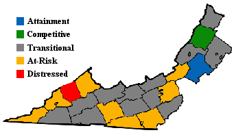
Appalachian Regional Commission
The Appalachian Regional Commission
Appalachian Regional Commission
The Appalachian Regional Commission is a United States federal-state partnership that works with the people of Appalachia to create opportunities for self-sustaining economic development and improved quality of life...
was formed in 1965 to aide economic development in the Appalachian region
Appalachia
Appalachia is a term used to describe a cultural region in the eastern United States that stretches from the Southern Tier of New York state to northern Alabama, Mississippi, and Georgia. While the Appalachian Mountains stretch from Belle Isle in Canada to Cheaha Mountain in the U.S...
, which was lagging far behind the rest of the nation on most economic indicators. The Appalachian region currently defined by the Commission includes 420 counties in 13 states, including the westernmost counties and cities in Virginia. The Commission gives each county one of five possible economic designations— distressed, at-risk, transitional, competitive, or attainment— with "distressed" counties being the most economically endangered and "attainment" counties being the most economically prosperous. These designations are based primarily on three indicators— three-year average unemployment rate, market income per capita, and poverty rate. For data collection purposes, independent cities within the designated region are grouped with an adjacent county.
In 2003, Appalachian Virginia— which included most of Southwestern Virginia— had a three-year average unemployment rate of 5.7%, compared with 3.8% statewide and 5.5% nationwide. In 2002, Appalachian Virginia had a per capita market income of $16,901, compared with $29,279 statewide and $26,420 nationwide. In 2000, Appalachian Virginia had a poverty rate of 15.7%, compared to 9.6% statewide and 12.4% nationwide.
Only one Virginia county— Dickenson
Dickenson County, Virginia
As of the census of 2000, there were 16,395 people, 6,732 households, and 4,887 families residing in the county. The population density was 49 people per square mile . There were 7,684 housing units at an average density of 23 per square mile...
— was designated "Distressed," while eight— Buchanan
Buchanan County, Virginia
As of the census of 2000, there were 26,978 people, 10,464 households, and 7,900 families residing in the county. The population density was 54 people per square mile . There were 11,887 housing units at an average density of 24 per square mile...
, Carroll
Carroll County, Virginia
As of the census of 2000, there were 29,245 people, 12,186 households, and 8,786 families residing in the county. The population density was 61 people per square mile . There were 14,680 housing units at an average density of 31 per square mile...
(includes Galax
Galax, Virginia
Galax is an independent city in the southwestern part of the Commonwealth of Virginia. It is bounded to the northeast by Carroll County and to the southwest by Grayson County. The population was 7,042 as of 2010...
), Craig
Craig County, Virginia
As of the census of 2000, there were 5,091 people, 2,060 households, and 1,507 families residing in the county. The population density was 15 people per square mile . There were 2,554 housing units at an average density of 8 per square mile...
, Grayson
Grayson County, Virginia
As of the census of 2000, there were 17,917 people, 7,259 households, and 5,088 families residing in the county. The population density was 40 people per square mile . There were 9,123 housing units at an average density of 21 per square mile...
, Lee
Lee County, Virginia
According to the census 2009 estimates, there were 25001 people, 11,587 households, and 6,852 families residing in the county. The population density was 54 people per square mile . There were 11,587 housing units at an average density of 25 per square mile...
, Montgomery
Montgomery County, Virginia
As of the census of 2000, there were 83,629 people, 30,997 households, and 17,203 families residing in the county. The population density was 215 people per square mile . There were 32,527 housing units at an average density of 84 per square mile...
(includes Radford
Radford, Virginia
Radford is a city in Virginia, United States. The population was 16,408 in 2010. For statistical purposes, the Bureau of Economic Analysis combines the city of Radford with neighboring Montgomery County, including the towns of Blacksburg and Christiansburg, calling the combination the...
), Smyth
Smyth County, Virginia
As of the census of 2000, there were 33,081 people, 13,493 households, and 9,607 families residing in the county. The population density was 73 people per square mile . There were 15,111 housing units at an average density of 33 per square mile...
, and Wise
Wise County, Virginia
Wise County is a county located in the U.S. state of Virginia. In 1856, the county was formed from land taken from Lee, Scott, and Russell Counties. It was named after Henry A. Wise, who was the Governor of Virginia at the time. As of 2010, the population was 41,452, making it the largest...
(includes Norton
Norton, Virginia
Norton is an independent city within the confines of Wise County in the Commonwealth of Virginia. As of the 2010 Census, the city population was 3,958, making it the smallest city in the state by population...
)— were designated "at-risk." Botetourt County
Botetourt County, Virginia
As of the census of 2000, there were 30,496 people, 11,700 households, and 9,114 families residing in the county. The population density was 56 people per square mile . There were 12,571 housing units at an average density of 23 per square mile...
was the only county given the "attainment" designation, and Bath
Bath County, Virginia
As of the census of 2000, there were 5,048 people, 2,053 households, and 1,451 families residing in the county. The population density was 10 people per square mile . There were 2,896 housing units at an average density of 5 per square mile...
was the only county designated "competitive." Most Appalachian Virginia counties were designated "transitional," meaning they lagged behind the national average on one of the three key indicators. Montgomery County
Montgomery County, Virginia
As of the census of 2000, there were 83,629 people, 30,997 households, and 17,203 families residing in the county. The population density was 215 people per square mile . There were 32,527 housing units at an average density of 84 per square mile...
had Appalachian Virginia's highest poverty rating, with 24.5% of its residents living below the poverty line. Botetourt
Botetourt County, Virginia
As of the census of 2000, there were 30,496 people, 11,700 households, and 9,114 families residing in the county. The population density was 56 people per square mile . There were 12,571 housing units at an average density of 23 per square mile...
had Appalachian Virginia's highest per capita income ($27,835) and lowest unemployment rate (2.7%).
See also
- AppalachiaAppalachiaAppalachia is a term used to describe a cultural region in the eastern United States that stretches from the Southern Tier of New York state to northern Alabama, Mississippi, and Georgia. While the Appalachian Mountains stretch from Belle Isle in Canada to Cheaha Mountain in the U.S...
- Southern West VirginiaSouthern West VirginiaSouthern West Virginia is a culturally and geographically distinct region in the U.S. state of West Virginia. Generally considered the heart of Appalachia, Southern West Virginia is known for its coal mining heritage and southern affinity...
- Tennessee ValleyTennessee ValleyThe Tennessee Valley is the drainage basin of the Tennessee River and is largely within the U.S. state of Tennessee. It stretches from southwest Kentucky to northwest Georgia and from northeast Mississippi to the mountains of Virginia and North Carolina...
- List of Appalachian Regional Commission counties#Virginia