
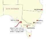
South Australia-Victoria border dispute
Encyclopedia
The border between the Australia
n states of South Australia
and Victoria
was established in 1836 by imperial
letters patent
"as the 141st degree meridian of longitude east of Greenwich
". Due to human error by numerous explorers and surveyors, it took more than 75 years and a protracted legal dispute before the precise placement of the border was settled, resulting in the forfeiture of more than 500 square miles (1,295 km²) of territory from South Australia to Victoria. In 1914, after a successful appeal to the United Kingdom's Judicial Committee of the Privy Council
, a sum of £215,000 was awarded to the state of South Australia and the legal dispute was ended.

was rapidly being settled by squatters
selecting large runs for sheep grazing. With no clear border legal oversight was impossible. An accurate border needed to be defined. The earliest relevant reference to the eastern boundary of South Australia is contained in a despatch dated 30 September 1844 from Governor Grey
of that Colony to Lord Stanley
. The Governor reminded the Secretary of State that it would be extremely difficult to determine with accuracy a number of points upon the earth's surface through which the 141st degree of East longitude passes, and pointed out that in addition to difficulty there would be attendant expense both in ascertainment and maintenance.
In 1839 Charles Tyers
was transferred from the Royal Navy
to the Colonial Service and instructed by Sir George Gipps
, the Governor of New South Wales, to ascertain the precise longitude at the mouth of the Glenelg River
so that a distance to the 141st meridian (the eastern border of South Australia) could be measured.
Several months later Tyers completed a survey from Melbourne
to the Glenelg River and on an expanse of sandy beach he formed a broad arrow with limestone rocks. This became known as Tyers' Mark and was used to determine the starting point for the border survey. Due to primarily inadequate equipment this was later determined to be 2 miles and 4 chains
(3.3 km) in error.
. South Australia
n pastoralists had worked their way east from the coast and there were disputes when they met pastoralists from the Wimmera
country pushing their way westwards with flocks of sheep.
There was uncertainty as to which Government should grant pastoral licenses to the squatters and which had legal control. In November 1846 the Colonial Secretary's Office directed surveyor Henry Wade to proceed from Sydney
to the disputed territory to define a "Boundary for Police Purposes".
By March 1847 Wade had got his party of seven and equipment at the mouth of the Glenelg River. He was joined by assistant surveyor Edward White who had been appointed by the South Australian government to act as an observer on its behalf.
After much deprivation and hardship due to drought and reluctance by his men to continue with poor work conditions, Wade was still 155 miles (250 km) from the Murray River
after nine months of swamp, sand dunes and broken equipment. The expedition collapsed at the 36th parallel of latitude
. On 16 December 1847 the South Australian Government published a proclamation that the "line as marked on the ground" by Wade should be "deemed and construed" to be the eastern boundary of South Australia. In March, 1849 New South Wales
issued a proclamation in similar terms. Wade later died in 1854.
As the survey was only partially completed the two colonies were in agreement that surveyor White should complete Wade's line to the Murray River
as soon as possible. This was doubly urgent as the state of Victoria was to be proclaimed within twelve months further complicating legal and later political matters.
In August 1849 the extension from Wade's line was begun. White and his party of five were similarly troubled by the severe nature of the Big Desert mallee
country: where there was little water in 1847 there was none two years later. Within two weeks mutinous men had deserted him and two of his three horses collapsed from being without water for four days. White led the other until it also lay down, he himself was also on the verge of collapse but he managed to bleed the horse and drink half a pint of the blood. Lost, he did not know how far from the Murray River he was but he managed to stagger on for about two miles (3.2 km) to find himself on the riverbank at the border of three states and the survey completed. After drinking and resting he retreated back to the dead horses and collecting his saddle and bridle he returned to the river, managed to cross it and borrow a horse at Chowilla sheep station. He rode 180 miles (290 km) to Adelaide
and filed a report on the survey. White died three years later.
 Doubts as to the accuracy of the Wade-White line grew with the availability of better astronomical equipment and the advent of the telegraph. As a result of appointments of Government Astronomer
s in Sydney
and Melbourne
there were far more precise values for the longitudes of these places and hence the 141st longitude of the legal border.
By agreement an expedition left Adelaide
in April 1868 for Chowilla near the Murray River
and the border. It was led by George Smalley, N.S.W. Government Astronomer and Charles Todd South Australian Superindentent of Telegraphs. The purpose was to make transit observations of eleven stars whilst similar observations were made in Melbourne and Sydney. Whilst Tyers had used a small three inch (76 mm) theodolite
this expedition had a 45 inches (1,143 mm) telescope, the largest available portable device in Australia at the time.
As a result of their observations Smalley and Todd declared the new 141st meridian
. This led to the discovery that the proclaimed border on the ground was at least two miles and 19 chains (3.6 km) to the west of the more accurate measurement of the 141st meridian. The "Disputed Territory" as it was termed between the surveyed border and the actual 141st meridian contained over 500 square miles (1295 km²) of land. By 1849, 47% of it had already been sold freehold or leased out by the Victorian Government. If the more accurate border were adopted, Victoria would not have owned the land to be able to sell or lease it. This was the beginning of the battle of the Disputed Territory, a bone of contention which was to last for more than forty years.
South Australia finally abandoned all hope of settlement, due to Victoria's intransigence, and in 1911 it appealed to the High Court
only to have the appeal dismissed. In 1914, it resorted to an appeal to the Privy Council
which unanimously ruled in favour of Victoria.
 When the railway line was built from Melbourne to Adelaide, a station was built in the disputed territory and paid for equally by both governments to provide a place for the exchange of locomotives and crews. While this station is no longer used, the building remains in the tiny town of Serviceton
.
Australia
Australia , officially the Commonwealth of Australia, is a country in the Southern Hemisphere comprising the mainland of the Australian continent, the island of Tasmania, and numerous smaller islands in the Indian and Pacific Oceans. It is the world's sixth-largest country by total area...
n states of South Australia
South Australia
South Australia is a state of Australia in the southern central part of the country. It covers some of the most arid parts of the continent; with a total land area of , it is the fourth largest of Australia's six states and two territories.South Australia shares borders with all of the mainland...
and Victoria
Victoria (Australia)
Victoria is the second most populous state in Australia. Geographically the smallest mainland state, Victoria is bordered by New South Wales, South Australia, and Tasmania on Boundary Islet to the north, west and south respectively....
was established in 1836 by imperial
British Empire
The British Empire comprised the dominions, colonies, protectorates, mandates and other territories ruled or administered by the United Kingdom. It originated with the overseas colonies and trading posts established by England in the late 16th and early 17th centuries. At its height, it was the...
letters patent
Letters Patent establishing the Province of South Australia
The Letters Patent establishing the Province of South Australia formally titled;was the document presented to the King to formally seek the approval to establish the province of South Australia. The Letters were dated 19 February 1836....
"as the 141st degree meridian of longitude east of Greenwich
141st meridian east
The 141st meridian east of Greenwich is a line of longitude that extends extends from the North Pole across the Arctic Ocean, Asia, the Pacific Ocean, Australasia, the Indian Ocean, the Southern Ocean, and Antarctica to the South Pole....
". Due to human error by numerous explorers and surveyors, it took more than 75 years and a protracted legal dispute before the precise placement of the border was settled, resulting in the forfeiture of more than 500 square miles (1,295 km²) of territory from South Australia to Victoria. In 1914, after a successful appeal to the United Kingdom's Judicial Committee of the Privy Council
Judicial Committee of the Privy Council
The Judicial Committee of the Privy Council is one of the highest courts in the United Kingdom. Established by the Judicial Committee Act 1833 to hear appeals formerly heard by the King in Council The Judicial Committee of the Privy Council (JCPC) is one of the highest courts in the United...
, a sum of £215,000 was awarded to the state of South Australia and the legal dispute was ended.
Tyers' survey
Following the establishment of the colony of South Australia in 1835, the region between the coast and the Murray RiverMurray River
The Murray River is Australia's longest river. At in length, the Murray rises in the Australian Alps, draining the western side of Australia's highest mountains and, for most of its length, meanders across Australia's inland plains, forming the border between New South Wales and Victoria as it...
was rapidly being settled by squatters
Squatting (pastoral)
In Australian history, a squatter was one who occupied a large tract of Crown land in order to graze livestock. Initially often having no legal rights to the land, they gained its usage by being the first Europeans in the area....
selecting large runs for sheep grazing. With no clear border legal oversight was impossible. An accurate border needed to be defined. The earliest relevant reference to the eastern boundary of South Australia is contained in a despatch dated 30 September 1844 from Governor Grey
George Edward Grey
Sir George Grey, KCB was a soldier, explorer, Governor of South Australia, twice Governor of New Zealand, Governor of Cape Colony , the 11th Premier of New Zealand and a writer.-Early life and exploration:...
of that Colony to Lord Stanley
Edward Smith-Stanley, 14th Earl of Derby
Edward George Geoffrey Smith-Stanley, 14th Earl of Derby, KG, PC was an English statesman, three times Prime Minister of the United Kingdom, and to date the longest serving leader of the Conservative Party. He was known before 1834 as Edward Stanley, and from 1834 to 1851 as Lord Stanley...
. The Governor reminded the Secretary of State that it would be extremely difficult to determine with accuracy a number of points upon the earth's surface through which the 141st degree of East longitude passes, and pointed out that in addition to difficulty there would be attendant expense both in ascertainment and maintenance.
In 1839 Charles Tyers
Charles Tyers
Captain Charles James Tyers RN FRSV was a 19th century surveyor and explorer, and the Commissioner for Crown Lands for Portland and Gippsland...
was transferred from the Royal Navy
Royal Navy
The Royal Navy is the naval warfare service branch of the British Armed Forces. Founded in the 16th century, it is the oldest service branch and is known as the Senior Service...
to the Colonial Service and instructed by Sir George Gipps
George Gipps
Sir George Gipps was Governor of the colony of New South Wales, Australia, for eight years, between 1838 and 1846. His governorship was during a period of great change for New South Wales and Australia, as well as for New Zealand, which was administered as part of New South Wales for much of this...
, the Governor of New South Wales, to ascertain the precise longitude at the mouth of the Glenelg River
Glenelg River (Victoria)
The Glenelg River is a river in southwestern Victoria and southeastern South Australia in Australia. The river starts in the Grampian Ranges and runs for over 350 kilometres, making it the longest river in south-west Victoria. A short stretch of the lower end winds through South Australia before...
so that a distance to the 141st meridian (the eastern border of South Australia) could be measured.
Several months later Tyers completed a survey from Melbourne
Melbourne
Melbourne is the capital and most populous city in the state of Victoria, and the second most populous city in Australia. The Melbourne City Centre is the hub of the greater metropolitan area and the Census statistical division—of which "Melbourne" is the common name. As of June 2009, the greater...
to the Glenelg River and on an expanse of sandy beach he formed a broad arrow with limestone rocks. This became known as Tyers' Mark and was used to determine the starting point for the border survey. Due to primarily inadequate equipment this was later determined to be 2 miles and 4 chains
Chain (unit)
A chain is a unit of length; it measures 66 feet or 22 yards or 100 links . There are 10 chains in a furlong, and 80 chains in one statute mile. An acre is the area of 10 square chains...
(3.3 km) in error.
Wade-White surveys
For several years following Tyers' survey no action was taken to extend his work but by 1845 the need to have the boundary line defined on the ground had become urgent, particularly to the east of Mount GambierMount Gambier, South Australia
Mount Gambier is the largest regional city in South Australia located approximately 450 kilometres south of the capital Adelaide and just 17 kilometres from the Victorian border....
. South Australia
South Australia
South Australia is a state of Australia in the southern central part of the country. It covers some of the most arid parts of the continent; with a total land area of , it is the fourth largest of Australia's six states and two territories.South Australia shares borders with all of the mainland...
n pastoralists had worked their way east from the coast and there were disputes when they met pastoralists from the Wimmera
Wimmera
The Wimmera is a region in the west of the Australian state of Victoria.It covers the dryland farming area south of the range of Mallee scrub, east of the South Australia border and north of the Great Dividing Range...
country pushing their way westwards with flocks of sheep.
There was uncertainty as to which Government should grant pastoral licenses to the squatters and which had legal control. In November 1846 the Colonial Secretary's Office directed surveyor Henry Wade to proceed from Sydney
Sydney
Sydney is the most populous city in Australia and the state capital of New South Wales. Sydney is located on Australia's south-east coast of the Tasman Sea. As of June 2010, the greater metropolitan area had an approximate population of 4.6 million people...
to the disputed territory to define a "Boundary for Police Purposes".
By March 1847 Wade had got his party of seven and equipment at the mouth of the Glenelg River. He was joined by assistant surveyor Edward White who had been appointed by the South Australian government to act as an observer on its behalf.
After much deprivation and hardship due to drought and reluctance by his men to continue with poor work conditions, Wade was still 155 miles (250 km) from the Murray River
Murray River
The Murray River is Australia's longest river. At in length, the Murray rises in the Australian Alps, draining the western side of Australia's highest mountains and, for most of its length, meanders across Australia's inland plains, forming the border between New South Wales and Victoria as it...
after nine months of swamp, sand dunes and broken equipment. The expedition collapsed at the 36th parallel of latitude
36th parallel south
The 36th parallel south is a circle of latitude that is 36 degrees south of the Earth's equatorial plane. It crosses the Atlantic Ocean, the Indian Ocean, Australasia, the Pacific Ocean and South America....
. On 16 December 1847 the South Australian Government published a proclamation that the "line as marked on the ground" by Wade should be "deemed and construed" to be the eastern boundary of South Australia. In March, 1849 New South Wales
New South Wales
New South Wales is a state of :Australia, located in the east of the country. It is bordered by Queensland, Victoria and South Australia to the north, south and west respectively. To the east, the state is bordered by the Tasman Sea, which forms part of the Pacific Ocean. New South Wales...
issued a proclamation in similar terms. Wade later died in 1854.
As the survey was only partially completed the two colonies were in agreement that surveyor White should complete Wade's line to the Murray River
Murray River
The Murray River is Australia's longest river. At in length, the Murray rises in the Australian Alps, draining the western side of Australia's highest mountains and, for most of its length, meanders across Australia's inland plains, forming the border between New South Wales and Victoria as it...
as soon as possible. This was doubly urgent as the state of Victoria was to be proclaimed within twelve months further complicating legal and later political matters.
In August 1849 the extension from Wade's line was begun. White and his party of five were similarly troubled by the severe nature of the Big Desert mallee
Mallee Woodlands and Shrublands
Mallee Woodlands and Shrublands is a Major Vegetation Group which occurs in semi-arid areas of southern Australia. The vegetation is dominated by mallee eucalypts which are rarely over 6 metres high...
country: where there was little water in 1847 there was none two years later. Within two weeks mutinous men had deserted him and two of his three horses collapsed from being without water for four days. White led the other until it also lay down, he himself was also on the verge of collapse but he managed to bleed the horse and drink half a pint of the blood. Lost, he did not know how far from the Murray River he was but he managed to stagger on for about two miles (3.2 km) to find himself on the riverbank at the border of three states and the survey completed. After drinking and resting he retreated back to the dead horses and collecting his saddle and bridle he returned to the river, managed to cross it and borrow a horse at Chowilla sheep station. He rode 180 miles (290 km) to Adelaide
Adelaide
Adelaide is the capital city of South Australia and the fifth-largest city in Australia. Adelaide has an estimated population of more than 1.2 million...
and filed a report on the survey. White died three years later.
Smalley and Todd survey
Astronomer
An astronomer is a scientist who studies celestial bodies such as planets, stars and galaxies.Historically, astronomy was more concerned with the classification and description of phenomena in the sky, while astrophysics attempted to explain these phenomena and the differences between them using...
s in Sydney
Sydney
Sydney is the most populous city in Australia and the state capital of New South Wales. Sydney is located on Australia's south-east coast of the Tasman Sea. As of June 2010, the greater metropolitan area had an approximate population of 4.6 million people...
and Melbourne
Melbourne
Melbourne is the capital and most populous city in the state of Victoria, and the second most populous city in Australia. The Melbourne City Centre is the hub of the greater metropolitan area and the Census statistical division—of which "Melbourne" is the common name. As of June 2009, the greater...
there were far more precise values for the longitudes of these places and hence the 141st longitude of the legal border.
By agreement an expedition left Adelaide
Adelaide
Adelaide is the capital city of South Australia and the fifth-largest city in Australia. Adelaide has an estimated population of more than 1.2 million...
in April 1868 for Chowilla near the Murray River
Murray River
The Murray River is Australia's longest river. At in length, the Murray rises in the Australian Alps, draining the western side of Australia's highest mountains and, for most of its length, meanders across Australia's inland plains, forming the border between New South Wales and Victoria as it...
and the border. It was led by George Smalley, N.S.W. Government Astronomer and Charles Todd South Australian Superindentent of Telegraphs. The purpose was to make transit observations of eleven stars whilst similar observations were made in Melbourne and Sydney. Whilst Tyers had used a small three inch (76 mm) theodolite
Theodolite
A theodolite is a precision instrument for measuring angles in the horizontal and vertical planes. Theodolites are mainly used for surveying applications, and have been adapted for specialized purposes in fields like metrology and rocket launch technology...
this expedition had a 45 inches (1,143 mm) telescope, the largest available portable device in Australia at the time.
As a result of their observations Smalley and Todd declared the new 141st meridian
Meridian (geography)
A meridian is an imaginary line on the Earth's surface from the North Pole to the South Pole that connects all locations along it with a given longitude. The position of a point along the meridian is given by its latitude. Each meridian is perpendicular to all circles of latitude...
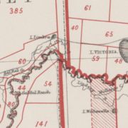
. This led to the discovery that the proclaimed border on the ground was at least two miles and 19 chains (3.6 km) to the west of the more accurate measurement of the 141st meridian. The "Disputed Territory" as it was termed between the surveyed border and the actual 141st meridian contained over 500 square miles (1295 km²) of land. By 1849, 47% of it had already been sold freehold or leased out by the Victorian Government. If the more accurate border were adopted, Victoria would not have owned the land to be able to sell or lease it. This was the beginning of the battle of the Disputed Territory, a bone of contention which was to last for more than forty years.
Legal dispute
The South Australian Government did not let the matter rest. In 1874 it suggested the value of the land was about £800,000. Between 1883 and 1893 South Australia sent more than 70 letters or telegrams to Melbourne seeking Victorian relinquishment or financial redress. There were many futile conferences. The nearest to an agreement between the two states was in 1908. Then it was decided, subject to ratification by parliament, that £215,000 should be regarded as compensation to South Australia. Parliament did not ratify the proposal, nor did anything come of the 1909 South Australian premier's plan to send surveyors to subdivide some of the land on the east of White's marked border, the last "legally proclaimed" border.South Australia finally abandoned all hope of settlement, due to Victoria's intransigence, and in 1911 it appealed to the High Court
High Court of Australia
The High Court of Australia is the supreme court in the Australian court hierarchy and the final court of appeal in Australia. It has both original and appellate jurisdiction, has the power of judicial review over laws passed by the Parliament of Australia and the parliaments of the States, and...
only to have the appeal dismissed. In 1914, it resorted to an appeal to the Privy Council
Privy Council of the United Kingdom
Her Majesty's Most Honourable Privy Council, usually known simply as the Privy Council, is a formal body of advisers to the Sovereign in the United Kingdom...
which unanimously ruled in favour of Victoria.
Serviceton
Serviceton, Victoria
Serviceton is a small town in Victoria, Australia, located near the Victorian-South Australian border, 437 kilometres north-west of Melbourne. The town was named after James Service, Premier of Victoria in 1880 and from 1883-86...
.