

Smestow Brook
Encyclopedia
The Smestow Brook, sometimes called the river Smestow, is a small river that plays an important part in the drainage of Wolverhampton
, South Staffordshire
, and parts of Dudley
in the United Kingdom
, and has contributed to the industrial development of the Black Country
. It is the most important tributary of the River Stour, Worcestershire
and part of the River Severn
catchment.
forms Smetheslall and Smethestalle. As late as the 19th century, the name was still generally rendered Smestall in surveys of the county. It means ″place of the smiths″. The whole of this part of the West Midlands was famed for iron production from the Middle Ages onwards. The nearby Kinver
Forest and Wyre Forest
supplied charcoal
for smelting
and working iron before the Industrial Revolution
. Both the lower Smestow and the Stour
were lined with bloomeries
and forges
, their water used for cooling and later to power simple machinery.
Some local people maintain that the lower part of the stream, approximately from Wombourne, is properly called the River Smestow, while the upper section is the Smestow Brook. Certainly the lower Smestow is much more impressive since dredging and course alterations in the 1990s. In practice, however, both forms are used for the whole length of the stream, with Smestow Brook predominating. Similarly, the term Smestow Valley is sometimes reserved for the narrow section from Aldersley to Wightwick, although it can be used for the entire catchment, including the much wider plain south of Trescott. The Smestow itself created neither of these features: it simply flows through a landscape opened up by glaciation in the last Ice Age
.
was constructed as a substitute for a navigable river, the Smestow supplying it with water.
 The Smestow flows through an important local nature reserve at Wolverhampton, and its lower course largely follows the conservation area associated with the canal, often through linear woodland, as well as small areas of wetland. Hence, it is home to a wide range of wildlife: if little is rare, the variety is great. Dredging and other works often disturb wildlife, but recolonization is usually rapid. The reduction in pollution over the last three decades has allowed wildlife to diversify and flourish.
The Smestow Valley reserve claims no less than 170 species of bird as residents or visitors, with 55 species breeding locally. Winter sees the greatest variety with the regular Blackbird and Chaffinch
reinforced by visitors, like Redwing
, Fieldfare
, Redpoll
, Siskin
, Little Grebe
, Snipe
, Lapwing
and Golden Plover. Raptors
like the Eurasian Buzzard and Sparrowhawk also hover.
Insect life is also rich and varied, with more than 20 kinds of butterfly seen on the reserve, including Ringlet, Common Blue, Holly Blue, Peacock, Red Admiral
, Painted Lady
, Green-veined White, Comma, Gatekeeper, Small Skipper, Large Skipper, Meadow Brown, Purple Hairstreak
, Small Heath and Small Copper and, rarely, Brimstone and Clouded Yellow. There is also a great variety of damselflies and dragonflies.
. Glacial action removed part of the low ridge, to the north of present-day Wolverhampton, which separates the River Trent
and River Severn
catchments, creating the Aldersley Gap. As a result, the Smestow was able to break through to the south, and was thus captured from the Trent by the Severn catchment.
In some areas, especially around Wolverhampton, the Smestow runs over beds of gravels, laid down in the last Ice Age. For a large part of its course, however, the Smestow flows over deep Bunter
deposits of sandstone, also known as Triassic
Sherwood sandstone - similar to the deposits underlying Sherwood Forest
in Nottinghamshire and Cannock Chase
in Staffordshire. These are highly permeable, allowing the land above to drain quickly and reducing the flow within river courses. As a result, the areas of South Staffordshire around the river, despite fairly high rainfall, had a natural vegetation of heath and open birch woodland. This was modified progressively after the Anglo-Saxon
settlement, with a gradual clearance of farmland. With the emergence of modern, high input farming, from the 18th century onwards, the aquifer became increasingly vulnerable to nitrate pollution. The relative decline of heavy industry in the region makes this the main, and growing, pollution threat to water supplies in the Smestow valley.
, where two camps were successively situated, one apparently using the stream as part of its fortifications. However, it was the Anglo-Saxon
settlement that brought significant permanent human habitation to the valley, and it is probably from these settlers that the stream took its name.
As remarked above, the banks of the Smestow and Stour were home to a thriving iron industry, based on locally-produced charcoal, from the Middle Ages until the 18th century. This included many small forges and bloomeries but also, from the mid-17th century, some fairly large enterprises run by wealthy businessmen, like those at the Grange near Trescott, Heath near WombourneS, Swindon, Greensforge, and Gothersley. To power the Heath Mill, a substantial canal was constructed to divert water from the Smestow at Trysull into a mill pond above the little valley of the Wom Brook
, whence it dropped into the brook, powering a series of mills, and then flowed back into the Smestow. These enterprises were stimulated by the demands of war, both civil and international: Greenforge sharpened the swords of civil war troopers, for example. Key names connected with these developments were the near-legendary Dud Dudley and the Foley
family.
After 1700, the spread of coke-fired blast furnaces in the Severn Valley and the Black Country brought charcoal-fired iron production gradually to an end. However, this signalled not the end but the transformation and further growth of iron-making and working along the Smestow. So important was this continued industrial activity, that James Brindley
was prevented from cutting off the flow of the upper Smestow when the Staffordshire and Worcestershire Canal was developed, around 1770. Instead he was forced to preserve the flow with a "water bridge" or aqueduct at Dunstall, in the Aldersley Gap, which carries the brook over the canal and releases it to descend to its natural course.
The canal itself allowed coal, coke and iron ore to be transported more easily, allowing industrialists to combine water and steam power, alongside coke-fired blast furnaces, wherever the river and canal ran close together. The result was the development of larger iron-works at Swindon and Gothersley on the Smestow, as well as nearby at the Hyde, near Kinver on the Stour - all situated between river and canal. The Swindon works included a rolling mill and generated power mainly from coal, although its drop hammer was driven by a large water wheel
. It was to last until 1976.
Although iron production was thus centralised, the small-scale, decentralised working of iron not only continued but increased. An 1817 commentator tells us that Swindon has "an iron-works, some forges, and a blade-mill, where by a peculiar temperament of the iron, it is formed into scythes, sickles, axes, &c." A survey of 1834 adds corn mills to the list of enterprises at Swindon. It also tells us that Wombourne is a large village, "occupied chiefly by nailors, who work for the neighbouring manufacturers". The nail-makers were thus mainly self-employed contractors, working in their own small forges on iron brought in from the large producers. The demand for water to power the forges continued and even rose well into the Victorian period, during which the Smestow powered at least 30 mills. In some cases, as at Greensforge and Heath, iron-working gave way ultimately to corn milling.
Meanwhile, the industries of north Wolverhampton continued to use the water of the Smestow for a range of purposes, not least to carry away effluent. From the 1870s water was extracted in large quantities at the source for the brewing industry. The large Springfield
Brewery that was built for William Butler at the source of the Smestow in 1873 was to operate until 1991, for much of its life in the hands of Mitchells & Butlers
.
The main reason that the brook itself often appears scant in flow and unimportant is that the rock beneath is highly-permeable sandstone. Hence, very large quantities of water can be locked away not far below the surface, in the underlying aquifer
. As early as 1851, the engineer Henry Marten gauged the supply at ten million gallons (approximately 45,000,000 litres) per day and proposed to extract water for drinking and industrial use from the Smestow. This was blocked by opposition from the carpet makers of Kidderminster
, who feared that extraction from the Smestow would affect the flow of the Stour, which they used to carry away their effluent.
The following year, Marten put forward a scheme for drinking water extraction from the lower Smestow. This time he sent water samples to analytical laboratories in London, where they were pronounced exceptionally clear and free from decaying matter. The aquifer beneath the sandstone is itself very vulnerable to pollution, and the actual river water at that time is unlikely to have been free of chemical and microbial pollution. Perhaps it is a good thing that Marten's idea was not put into practice until the 1890s, when a large pumping station was constructed at Ashwood, south of Swindon, to supply water to Black Country industry. This was soon followed by the Bratch
pumping station at Wombourne, built to supply Bilston
with drinking water. Both of these extracted water from the aquifer, not directly from the river, and were actually sited closer to the canal, which could be used to supply them with coal.
In the 20th century deliberate attempts were made to clean up the Smestow. These, together with the almost total collapse of heavy industry in Wolverhampton and the Black Country during the 1980s, have allowed the river to recover from earlier pollution. Today the water is clear and the courses of the river and the canal are important wildlife havens.
In South Staffordshire
, travelling upstream from the Stour confluence:
In Wolverhampton
:
Wolverhampton
Wolverhampton is a city and metropolitan borough in the West Midlands, England. For Eurostat purposes Walsall and Wolverhampton is a NUTS 3 region and is one of five boroughs or unitary districts that comprise the "West Midlands" NUTS 2 region...
, South Staffordshire
South Staffordshire
South Staffordshire is a local government district in Staffordshire, England. The district lies to the north and west of Wolverhampton and the West Midlands, bordering Shropshire to the west and Worcestershire to the south...
, and parts of Dudley
Metropolitan Borough of Dudley
The Metropolitan Borough of Dudley is a metropolitan borough in the West Midlands of England. It was created in 1974, and is made up of the towns of Dudley , Stourbridge , Halesowen, Brierley Hill, Amblecote, Sedgley and Coseley...
in the United Kingdom
United Kingdom
The United Kingdom of Great Britain and Northern IrelandIn the United Kingdom and Dependencies, other languages have been officially recognised as legitimate autochthonous languages under the European Charter for Regional or Minority Languages...
, and has contributed to the industrial development of the Black Country
Black Country
The Black Country is a loosely defined area of the English West Midlands conurbation, to the north and west of Birmingham, and to the south and east of Wolverhampton. During the industrial revolution in the 19th century this area had become one of the most intensely industrialised in the nation...
. It is the most important tributary of the River Stour, Worcestershire
River Stour, Worcestershire
The Stour is a river flowing through the counties of Worcestershire, the West Midlands and Staffordshire in the West Midlands region of England. The Stour is a major tributary of the River Severn, and it is about in length...
and part of the River Severn
River Severn
The River Severn is the longest river in Great Britain, at about , but the second longest on the British Isles, behind the River Shannon. It rises at an altitude of on Plynlimon, Ceredigion near Llanidloes, Powys, in the Cambrian Mountains of mid Wales...
catchment.
Etymology and Usage
The name of the stream may be of Anglo-Saxon origin, although it was not written down before the 14th century in the Middle EnglishMiddle English
Middle English is the stage in the history of the English language during the High and Late Middle Ages, or roughly during the four centuries between the late 11th and the late 15th century....
forms Smetheslall and Smethestalle. As late as the 19th century, the name was still generally rendered Smestall in surveys of the county. It means ″place of the smiths″. The whole of this part of the West Midlands was famed for iron production from the Middle Ages onwards. The nearby Kinver
Kinver
Kinver is a large village in South Staffordshire district, Staffordshire, England. It is in the far south-west of the county, at the end of the narrow finger of land surrounded by the counties of Shropshire, Worcestershire and the West Midlands. The nearest towns are Stourbridge in the West...
Forest and Wyre Forest
Wyre Forest
Wyre Forest is a large, semi-natural woodland and forest which straddles the borders of Worcestershire and Shropshire, England.The Wyre Forest district of Worcestershire takes its name from the forest, despite the fact that much of the woodland does not lie within the district's boundaries, but...
supplied charcoal
Charcoal
Charcoal is the dark grey residue consisting of carbon, and any remaining ash, obtained by removing water and other volatile constituents from animal and vegetation substances. Charcoal is usually produced by slow pyrolysis, the heating of wood or other substances in the absence of oxygen...
for smelting
Smelting
Smelting is a form of extractive metallurgy; its main use is to produce a metal from its ore. This includes iron extraction from iron ore, and copper extraction and other base metals from their ores...
and working iron before the Industrial Revolution
Industrial Revolution
The Industrial Revolution was a period from the 18th to the 19th century where major changes in agriculture, manufacturing, mining, transportation, and technology had a profound effect on the social, economic and cultural conditions of the times...
. Both the lower Smestow and the Stour
River Stour, Worcestershire
The Stour is a river flowing through the counties of Worcestershire, the West Midlands and Staffordshire in the West Midlands region of England. The Stour is a major tributary of the River Severn, and it is about in length...
were lined with bloomeries
Bloomery
A bloomery is a type of furnace once widely used for smelting iron from its oxides. The bloomery was the earliest form of smelter capable of smelting iron. A bloomery's product is a porous mass of iron and slag called a bloom. This mix of slag and iron in the bloom is termed sponge iron, which...
and forges
Forges
-In France:*Forges, Charente-Maritime, in the Charente-Maritime department*Forges, Maine-et-Loire, in the Maine-et-Loire department*Forges, Orne, in the Orne department*Forges, Seine-et-Marne, in the Seine-et-Marne department*Forgès, in the Corrèze department...
, their water used for cooling and later to power simple machinery.
Some local people maintain that the lower part of the stream, approximately from Wombourne, is properly called the River Smestow, while the upper section is the Smestow Brook. Certainly the lower Smestow is much more impressive since dredging and course alterations in the 1990s. In practice, however, both forms are used for the whole length of the stream, with Smestow Brook predominating. Similarly, the term Smestow Valley is sometimes reserved for the narrow section from Aldersley to Wightwick, although it can be used for the entire catchment, including the much wider plain south of Trescott. The Smestow itself created neither of these features: it simply flows through a landscape opened up by glaciation in the last Ice Age
Ice age
An ice age or, more precisely, glacial age, is a generic geological period of long-term reduction in the temperature of the Earth's surface and atmosphere, resulting in the presence or expansion of continental ice sheets, polar ice sheets and alpine glaciers...
.
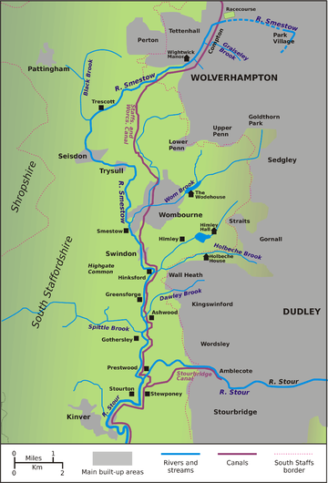
Course
- The Smestow Brook has its source in the Springfield area, to the north-east of Wolverhampton city centre, in which many of the street names attest to the plentiful supplies of water originally found there. However, the natural springs were contained and culverted as building began here in the 1870s, with large quantities diverted to the Springfield Brewery. Note the street name and the disused brewery, since finally demolished, in the background of the photograph.
- Today there is no sign of the Smestow for several hundred metres from its putative source in Springfield. It emerges further north, in the Park VillagePark VillagePark Village is an inner city area of Wolverhampton, West Midlands, England. It is situated in the north-east of the city on the A460 Cannock Road, which at that point is the border between the city council's Bushbury South and Low Hill and Heath Town wards....
area, at the edge of Fowler's Park. - The Smestow flows northwards through the park, supplying water for a pool.
- The Smestow then turns sharply to the west and disappears into a culvert, which takes it under the major roads and railway lines to the north of Wolverhampton, as well as under the BCN Main LineBCN Main LineThe BCN Main Line, or Birmingham Canal Navigations Main Line describes the evolving route of the Birmingham Canal between Birmingham and Wolverhampton in England....
canal. - It emerges by Wolverhampton RacecourseWolverhampton RacecourseWolverhampton Racecourse is a thoroughbred horse racing venue located in Wolverhampton, West Midlands, England. The track was the first to be floodlit in Britain and often holds meetings in the evening....
at Dunstall, where a small lake provides both flood relief and a wildlife haven. It is then taken over the Staffordshire and Worcestershire CanalStaffordshire and Worcestershire CanalThe Staffordshire and Worcestershire Canal is a narrow navigable canal in the English Midlands, passing through the counties of Staffordshire and Worcestershire....
by an aqueductAqueductAn aqueduct is a water supply or navigable channel constructed to convey water. In modern engineering, the term is used for any system of pipes, ditches, canals, tunnels, and other structures used for this purpose....
, the Dunstall Water Bridge. - The aqueduct was provided by James BrindleyJames BrindleyJames Brindley was an English engineer. He was born in Tunstead, Derbyshire, and lived much of his life in Leek, Staffordshire, becoming one of the most notable engineers of the 18th century.-Early life:...
to maintain the flow of water in the Smestow and the Stour, both important sources of power to 18th century industry. The Smestow then descends to the level of the canal. - The Smestow runs down the length of the Smestow Valley Local Nature Reserve, under the main Wolverhampton – Tettenhall road, and past Tettenhall Station, formerly on the Wombourne Branch Line but now a ranger station.
- Here the valley is hemmed in on both sides by steep slopes. The brook flows between the Wolverhampton suburbs of ComptonCompton, WolverhamptonCompton is a suburb of Wolverhampton, West Midlands, England. It is located to the west of Wolverhampton city centre on the A454, within the Tettenhall Wightwick ward.- History :...
and TettenhallTettenhallTettenhall is a historic part of the city of Wolverhampton, England. The name Tettenhall is probably derived from Teotta's Halh, Teotta being a person's name and Halh being a sheltered position...
, being joined by the Graiseley Brook and the Finchfield Brook, which drain areas to the south-west of Wolverhampton city centre. It passes through Wightwick, where it is overlooked by Wightwick ManorWightwick ManorWightwick Manor is a Victorian manor house located on Wightwick Bank, Wolverhampton, West Midlands, England, and one of only a few surviving examples of a house built and furnished under the influence of the Arts and Crafts movement...
. - At Wightwick the brook begins to diverge for some kilometres from the route of the canal, just south of the main Wolverhampton to BridgnorthBridgnorthBridgnorth is a town in Shropshire, England, along the Severn Valley. It is split into Low Town and High Town, named on account of their elevations relative to the River Severn, which separates the upper town on the right bank from the lower on the left...
road. Although mainly inaccessible to the public, the green trail of the river is easily visible for some distance as it snakes across open farmland. - The innocent looking Trescott Ford is notorious for catching unwary motorists after heavy local downpours.
- Passing through the hamlet of Furnace Grange, the Smestow takes a turn southward as it is joined from the right by the Black Brook, a considerable tributary.
- The brook swings south-east through the village of SeisdonSeisdonSeisdon is a rural village in the county of Staffordshire approximately six miles west of Wolverhampton.-Etymology:The name appears to mean "hill of the Saxons", deriving from the Anglo-Saxon words Seis meaning Saxon and Dun meaning hill.-History:...
, where it flows between properties, bordering their gardens. - The same is true at TrysullTrysullTrysull is a village situated in Staffordshire, England. It is situated within the South Staffordshire District, having been part of Seisdon Rural District until 1974....
. It then turns definitively south, grazing the south-western edge of WombourneWombourneWombourne is a very large village and civil parish located in the district of South Staffordshire, in the county of Staffordshire, 4 miles south-west of Wolverhampton. Local affairs are run by a parish council. At the 2001 census it had a population of 13,691...
, where it used to cause major flooding problems until its course was reshaped in the 1990s. Here it is joined by its most important tributary, the Wom Brook. From this point the Smestow again runs within a few hundred metres of the Staffordshire and Worcestershire Canal. - Passing the hamlet of Smestow it runs to SwindonSwindon, StaffordshireSwindon is a village located in Staffordshire, just outside the West Midlands conurbation. The nearest major town is Dudley, approximately five miles eastwards. It stands halfway between the small town of Kingswinford and village of Wombourne....
, from where it shadows the canal very closely, sometimes separated from it only by the width of the towpath. Here the reinforcement of the banks (to prevent collapse during flooding) is very evident. - The meandering course crosses open farmland but is mostly screened from it by linear woodland. At GreensforgeGreensforgeGreensforge is a scattered hamlet on the boundary of Kinver and Swindon parishes, in South Staffordshire, England. It is noted for its Roman associations and its industrial heritage.-Etymology:...
it passes a former Victorian corn mill, marking the site of one of the most important forges of earlier centuries, but now converted to apartments. - The valley narrows considerably between steep sandstone ridges after the river passes through AshwoodAshwood, StaffordshireAshwood is a small area of Staffordshire, England.It is situated in the South Staffordshire district, approximately two miles west of the West Midlands conurbation and the Metropolitan Borough of Dudley....
. The marina at Ashwood coincides with the descent of the Dawley Brook to join the Smestow. This confluence provided Roman soldiers with a natural moat to protect one of the forts, which are generally named after Greensforge. - At Gothersley, just south of Ashwood, the Spittle Brook joins from the right. Here the two streams water a small but valuable area of wetland.
- Finally, at Prestwood, close to Stourton and Kinver, the Smestow enters the StourRiver Stour, WorcestershireThe Stour is a river flowing through the counties of Worcestershire, the West Midlands and Staffordshire in the West Midlands region of England. The Stour is a major tributary of the River Severn, and it is about in length...
. After rain, the darker material from upstream shows up very clearly as it flows into the sandy Stour. The Stour swings south, taking the Smestow's course, to join the River SevernRiver SevernThe River Severn is the longest river in Great Britain, at about , but the second longest on the British Isles, behind the River Shannon. It rises at an altitude of on Plynlimon, Ceredigion near Llanidloes, Powys, in the Cambrian Mountains of mid Wales...
at Stourport-on-SevernStourport-on-SevernStourport-on-Severn, often shortened to Stourport, is a town and civil parish in the Wyre Forest District of North Worcestershire, England, a few miles to the south of Kidderminster and down stream on the River Severn from Bewdley...
: its waters ultimately discharge into the Atlantic OceanAtlantic OceanThe Atlantic Ocean is the second-largest of the world's oceanic divisions. With a total area of about , it covers approximately 20% of the Earth's surface and about 26% of its water surface area...
via the Bristol Channel.
Navigability
The Smestow is entirely non-navigable. However, its valley forms a natural north-south route of such importance that the Staffordshire and Worcestershire CanalStaffordshire and Worcestershire Canal
The Staffordshire and Worcestershire Canal is a narrow navigable canal in the English Midlands, passing through the counties of Staffordshire and Worcestershire....
was constructed as a substitute for a navigable river, the Smestow supplying it with water.
Natural history
The Smestow Valley reserve claims no less than 170 species of bird as residents or visitors, with 55 species breeding locally. Winter sees the greatest variety with the regular Blackbird and Chaffinch
Chaffinch
The Chaffinch , also called by a wide variety of other names, is a small passerine bird in the finch family Fringillidae.- Description :...
reinforced by visitors, like Redwing
Redwing
The Redwing is a bird in the thrush family Turdidae, native to Europe and Asia, slightly smaller than the related Song Thrush.-Taxonomy:...
, Fieldfare
Fieldfare
The Fieldfare is a member of the thrush family Turdidae. It breeds in woodland and scrub in northern Europe and Asia. It is strongly migratory, with many northern birds moving south during the winter. It is a very rare breeder in Great Britain and Ireland, but winters in large numbers in these...
, Redpoll
Redpoll
The Redpolls are a group of small passerine birds in the finch family Fringillidae which have characteristic red markings on their heads. They were formerly placed into the genus Acanthis together with the linnets and the twite, but their closest relatives are actually the crossbills, that are...
, Siskin
Siskin
-Birds:The name siskin when referring to a bird is derived from an adaptation of the German dialect words sisschen, zeischen, which are diminuative forms of Middle High German and Middle Low German words, which are themselves apparently of Slavic origin...
, Little Grebe
Little Grebe
The Little Grebe , also known as Dabchick, member of the grebe family of water birds. At 23 to 29 cm in length it is the smallest European member of its family. It is commonly found in open bodies of water across most of its range.-Description:The Little Grebe is a small water bird with a pointed...
, Snipe
Snipe
A snipe is any of about 25 wading bird species in three genera in the family Scolopacidae. They are characterized by a very long, slender bill and crypsis plumage. The Gallinago snipes have a nearly worldwide distribution, the Lymnocryptes Jack Snipe is restricted to Asia and Europe and the...
, Lapwing
Lapwing
Vanellinae are any of various crested plovers, family Charadriidae, noted for its slow, irregular wingbeat in flight and a shrill, wailing cry. Its length is 10-16 inches. They are a subfamily of medium-sized wading birds which also includes the plovers and dotterels. The Vanellinae are...
and Golden Plover. Raptors
Bird of prey
Birds of prey are birds that hunt for food primarily on the wing, using their keen senses, especially vision. They are defined as birds that primarily hunt vertebrates, including other birds. Their talons and beaks tend to be relatively large, powerful and adapted for tearing and/or piercing flesh....
like the Eurasian Buzzard and Sparrowhawk also hover.
Insect life is also rich and varied, with more than 20 kinds of butterfly seen on the reserve, including Ringlet, Common Blue, Holly Blue, Peacock, Red Admiral
Red Admiral
The Red Admiral is a well-known colourful butterfly, found in temperate Europe, Asia and North America. The Red Admiral has a wing span. The species is resident only in warmer areas, but migrates north in spring, and sometimes again in autumn.This large butterfly is identified by its striking...
, Painted Lady
Painted Lady
The Cynthia group of colourful butterflies, commonly called painted ladies, comprises a subgenus of the genus Vanessa in the Family Nymphalidae...
, Green-veined White, Comma, Gatekeeper, Small Skipper, Large Skipper, Meadow Brown, Purple Hairstreak
Purple Hairstreak
The Purple Hairstreak Neozephyrus quercus is a butterfly in the family Lycaenidae distributed throughout much of Europe. North Africa, Asia Minor, Caucasus and Transcaucasia....
, Small Heath and Small Copper and, rarely, Brimstone and Clouded Yellow. There is also a great variety of damselflies and dragonflies.
Geology
The Smestow took its present shape as a result of the last Ice AgeIce age
An ice age or, more precisely, glacial age, is a generic geological period of long-term reduction in the temperature of the Earth's surface and atmosphere, resulting in the presence or expansion of continental ice sheets, polar ice sheets and alpine glaciers...
. Glacial action removed part of the low ridge, to the north of present-day Wolverhampton, which separates the River Trent
River Trent
The River Trent is one of the major rivers of England. Its source is in Staffordshire on the southern edge of Biddulph Moor. It flows through the Midlands until it joins the River Ouse at Trent Falls to form the Humber Estuary, which empties into the North Sea below Hull and Immingham.The Trent...
and River Severn
River Severn
The River Severn is the longest river in Great Britain, at about , but the second longest on the British Isles, behind the River Shannon. It rises at an altitude of on Plynlimon, Ceredigion near Llanidloes, Powys, in the Cambrian Mountains of mid Wales...
catchments, creating the Aldersley Gap. As a result, the Smestow was able to break through to the south, and was thus captured from the Trent by the Severn catchment.
In some areas, especially around Wolverhampton, the Smestow runs over beds of gravels, laid down in the last Ice Age. For a large part of its course, however, the Smestow flows over deep Bunter
Bunter (geology)
Bunter beds are sandstone deposits containing rounded pebbles, such as can notably be found in Warwickshire, Cheshire, Staffordshire, Nottinghamshire, Yorkshire, Devon and Dorset in England...
deposits of sandstone, also known as Triassic
Triassic
The Triassic is a geologic period and system that extends from about 250 to 200 Mya . As the first period of the Mesozoic Era, the Triassic follows the Permian and is followed by the Jurassic. Both the start and end of the Triassic are marked by major extinction events...
Sherwood sandstone - similar to the deposits underlying Sherwood Forest
Sherwood Forest
Sherwood Forest is a Royal Forest in Nottinghamshire, England, that is famous through its historical association with the legend of Robin Hood. Continuously forested since the end of the Ice Age, Sherwood Forest National Nature Reserve today encompasses 423 hectares surrounding the village of...
in Nottinghamshire and Cannock Chase
Cannock Chase
Cannock Chase is a mixed area of countryside in the county of Staffordshire, England. The area has been designated as the Cannock Chase Area of Outstanding Natural Beauty. The Chase gives its name to the Cannock Chase local government district....
in Staffordshire. These are highly permeable, allowing the land above to drain quickly and reducing the flow within river courses. As a result, the areas of South Staffordshire around the river, despite fairly high rainfall, had a natural vegetation of heath and open birch woodland. This was modified progressively after the Anglo-Saxon
Anglo-Saxon
Anglo-Saxon may refer to:* Anglo-Saxons, a group that invaded Britain** Old English, their language** Anglo-Saxon England, their history, one of various ships* White Anglo-Saxon Protestant, an ethnicity* Anglo-Saxon economy, modern macroeconomic term...
settlement, with a gradual clearance of farmland. With the emergence of modern, high input farming, from the 18th century onwards, the aquifer became increasingly vulnerable to nitrate pollution. The relative decline of heavy industry in the region makes this the main, and growing, pollution threat to water supplies in the Smestow valley.
History and Economic Importance
The Smestow runs very close to a number of important Roman sites, the most important being at GreensforgeGreensforge
Greensforge is a scattered hamlet on the boundary of Kinver and Swindon parishes, in South Staffordshire, England. It is noted for its Roman associations and its industrial heritage.-Etymology:...
, where two camps were successively situated, one apparently using the stream as part of its fortifications. However, it was the Anglo-Saxon
Anglo-Saxon
Anglo-Saxon may refer to:* Anglo-Saxons, a group that invaded Britain** Old English, their language** Anglo-Saxon England, their history, one of various ships* White Anglo-Saxon Protestant, an ethnicity* Anglo-Saxon economy, modern macroeconomic term...
settlement that brought significant permanent human habitation to the valley, and it is probably from these settlers that the stream took its name.
As remarked above, the banks of the Smestow and Stour were home to a thriving iron industry, based on locally-produced charcoal, from the Middle Ages until the 18th century. This included many small forges and bloomeries but also, from the mid-17th century, some fairly large enterprises run by wealthy businessmen, like those at the Grange near Trescott, Heath near WombourneS, Swindon, Greensforge, and Gothersley. To power the Heath Mill, a substantial canal was constructed to divert water from the Smestow at Trysull into a mill pond above the little valley of the Wom Brook
Wom Brook
The Wom Brook is a stream/brook located within South Staffordshire, England. It flows through the large village of Wombourne, and has played an important part in its industrial history. It is an important tributary of the River Smestow and part of the Severn catchment.-Etymology:The name of the...
, whence it dropped into the brook, powering a series of mills, and then flowed back into the Smestow. These enterprises were stimulated by the demands of war, both civil and international: Greenforge sharpened the swords of civil war troopers, for example. Key names connected with these developments were the near-legendary Dud Dudley and the Foley
Baron Foley
Baron Foley is a title that has been created twice in the Peerage of Great Britain, both times for members of the same family. The first creation came in 1712 in favour of Thomas Foley, who had earlier represented Stafford in the House of Commons. He was the grandson of the prominent ironmaster...
family.
After 1700, the spread of coke-fired blast furnaces in the Severn Valley and the Black Country brought charcoal-fired iron production gradually to an end. However, this signalled not the end but the transformation and further growth of iron-making and working along the Smestow. So important was this continued industrial activity, that James Brindley
James Brindley
James Brindley was an English engineer. He was born in Tunstead, Derbyshire, and lived much of his life in Leek, Staffordshire, becoming one of the most notable engineers of the 18th century.-Early life:...
was prevented from cutting off the flow of the upper Smestow when the Staffordshire and Worcestershire Canal was developed, around 1770. Instead he was forced to preserve the flow with a "water bridge" or aqueduct at Dunstall, in the Aldersley Gap, which carries the brook over the canal and releases it to descend to its natural course.
The canal itself allowed coal, coke and iron ore to be transported more easily, allowing industrialists to combine water and steam power, alongside coke-fired blast furnaces, wherever the river and canal ran close together. The result was the development of larger iron-works at Swindon and Gothersley on the Smestow, as well as nearby at the Hyde, near Kinver on the Stour - all situated between river and canal. The Swindon works included a rolling mill and generated power mainly from coal, although its drop hammer was driven by a large water wheel
Water wheel
A water wheel is a machine for converting the energy of free-flowing or falling water into useful forms of power. A water wheel consists of a large wooden or metal wheel, with a number of blades or buckets arranged on the outside rim forming the driving surface...
. It was to last until 1976.
Although iron production was thus centralised, the small-scale, decentralised working of iron not only continued but increased. An 1817 commentator tells us that Swindon has "an iron-works, some forges, and a blade-mill, where by a peculiar temperament of the iron, it is formed into scythes, sickles, axes, &c." A survey of 1834 adds corn mills to the list of enterprises at Swindon. It also tells us that Wombourne is a large village, "occupied chiefly by nailors, who work for the neighbouring manufacturers". The nail-makers were thus mainly self-employed contractors, working in their own small forges on iron brought in from the large producers. The demand for water to power the forges continued and even rose well into the Victorian period, during which the Smestow powered at least 30 mills. In some cases, as at Greensforge and Heath, iron-working gave way ultimately to corn milling.
Meanwhile, the industries of north Wolverhampton continued to use the water of the Smestow for a range of purposes, not least to carry away effluent. From the 1870s water was extracted in large quantities at the source for the brewing industry. The large Springfield
Springfield, Wolverhampton
Springfield is an area of Wolverhampton in the United Kingdom near the city centre, currently undergoing major redevelopment.Landmarks within the district include the site of Wolverhampton Low Level railway station, and the disused Springfield Brewery that made Springfield Bitter from 1873 to 1991....
Brewery that was built for William Butler at the source of the Smestow in 1873 was to operate until 1991, for much of its life in the hands of Mitchells & Butlers
Mitchells & Butlers
Mitchells & Butlers plc runs around 2,000 managed pubs, bars and restaurants throughout the United Kingdom. The Company's headquarters is in Birmingham, England, United Kingdom...
.
The main reason that the brook itself often appears scant in flow and unimportant is that the rock beneath is highly-permeable sandstone. Hence, very large quantities of water can be locked away not far below the surface, in the underlying aquifer
Aquifer
An aquifer is a wet underground layer of water-bearing permeable rock or unconsolidated materials from which groundwater can be usefully extracted using a water well. The study of water flow in aquifers and the characterization of aquifers is called hydrogeology...
. As early as 1851, the engineer Henry Marten gauged the supply at ten million gallons (approximately 45,000,000 litres) per day and proposed to extract water for drinking and industrial use from the Smestow. This was blocked by opposition from the carpet makers of Kidderminster
Kidderminster
Kidderminster is a town, in the Wyre Forest district of Worcestershire, England. It is located approximately seventeen miles south-west of Birmingham city centre and approximately fifteen miles north of Worcester city centre. The 2001 census recorded a population of 55,182 in the town...
, who feared that extraction from the Smestow would affect the flow of the Stour, which they used to carry away their effluent.
The following year, Marten put forward a scheme for drinking water extraction from the lower Smestow. This time he sent water samples to analytical laboratories in London, where they were pronounced exceptionally clear and free from decaying matter. The aquifer beneath the sandstone is itself very vulnerable to pollution, and the actual river water at that time is unlikely to have been free of chemical and microbial pollution. Perhaps it is a good thing that Marten's idea was not put into practice until the 1890s, when a large pumping station was constructed at Ashwood, south of Swindon, to supply water to Black Country industry. This was soon followed by the Bratch
Bratch
The Bratch is an area of Wombourne in Southern Staffordshire, England, noted for its industrial heritage and as a way station for walkers, riders and cyclists...
pumping station at Wombourne, built to supply Bilston
Bilston
Bilston is a town in the English county of West Midlands, situated in the southeastern corner of the City of Wolverhampton. Three wards of Wolverhampton City Council cover the town: Bilston East and Bilston North, which almost entirely comprise parts of the historic Borough of Bilston, and...
with drinking water. Both of these extracted water from the aquifer, not directly from the river, and were actually sited closer to the canal, which could be used to supply them with coal.
In the 20th century deliberate attempts were made to clean up the Smestow. These, together with the almost total collapse of heavy industry in Wolverhampton and the Black Country during the 1980s, have allowed the river to recover from earlier pollution. Today the water is clear and the courses of the river and the canal are important wildlife havens.
Tributaries
The Smestow is enlarged by water from a number of tributaries. Travelling upstream from the Stour confluence, they include:- The Spittle Brook, which drains the area north of EnvilleEnville, StaffordshireEnville is a small village in rural Staffordshire, England, on the A458 road between Stourbridge and Bridgnorth. Enville is also the name of the parish in which it lies....
, almost as far as Six Ashes, on the lip of the Severn valley, and flows down through a boggy area to join the Smestow near Gothersley. - The Dawley Brook, which drains the KingswinfordKingswinfordKingswinford is a suburban area in the West Midlands.Historically within Staffordshire, the area is mentioned in the Domesday Book its name relates to a ford for the King's swine - Latin Swinford Regis. The current significance is probably in tourism, education and housing...
area and fills the AshwoodAshwood, StaffordshireAshwood is a small area of Staffordshire, England.It is situated in the South Staffordshire district, approximately two miles west of the West Midlands conurbation and the Metropolitan Borough of Dudley....
basin or marina, before joining the Smestow. - The Holbeche Brook, which begins near Gornalwood and flows past Holbeche HouseHolbeche HouseHolbeche House is a mansion located near Kingswinford, on the borders of Staffordshire. It is the building in which some of the central Gunpowder plotters were captured, and the rest killed.-Gunpowder Plot:...
to join the Smestow at Hinksford. - The Wom Brook, which drains an area as far afield as Penn CommonPenn, West MidlandsPenn is an area now divided between Wolverhampton in the West Midlands and South Staffordshire. Originally, it was a village in the historic county of Staffordshire. There is considerable confusion about exactly which areas fall within Penn...
and SedgleySedgleySedgley is an urban village within the West Midlands county of England. Historically a part of Staffordshire, Sedgley was formerly an ancient manor composed of several smaller villages, including Gornal, Gospel End, Woodsetton, Ettingshall, Coseley and Brierley...
, flows through WombourneWombourneWombourne is a very large village and civil parish located in the district of South Staffordshire, in the county of Staffordshire, 4 miles south-west of Wolverhampton. Local affairs are run by a parish council. At the 2001 census it had a population of 13,691...
via the great pool at the Wodehouse, and joins the Smestow south of the village - The Black Brook, which drains the area almost up to PertonPertonPerton is a large village and civil parish located in Staffordshire, England. It lies to the south of Codsall, and to the west of the city of Wolverhampton.-Perton:...
and PattinghamPattinghamPattingham is a village in South Staffordshire, close to the border with Shropshire. The village is seven miles to the west of Wolverhampton and seven and a half miles east of Bridgnorth....
, and joins the Smestow near Trescott. - The Perton Brook, which tumbles down Wightwick Bank and waters the gardens of Wightwick Manor.
- The FinchfieldFinchfieldFinchfield is a suburb of Wolverhampton, West Midlands, England. It is located south-west of the city centre, within the Tettenhall Wightwick Ward between the Merry Hill and Tettenhall Regis Wards of Wolverhampton City Council. Many of the streets have Arboreal/Plant related...
and GraiseleyGraiseleyGraiseley is both an inner-city area of Wolverhampton, situated immediately to the south-west of the city centre, and the name of a ward of Wolverhampton City Council.-Place-name:...
Brooks, which drain the west of Wolverhampton, and join the Smestow in the Smestow Valley Local Nature Reserve.
Settlements
The Smestow flows through or past a number of settlements - many associated with the historic iron industry, or with the canal.In South Staffordshire
South Staffordshire
South Staffordshire is a local government district in Staffordshire, England. The district lies to the north and west of Wolverhampton and the West Midlands, bordering Shropshire to the west and Worcestershire to the south...
, travelling upstream from the Stour confluence:
- AshwoodAshwood, StaffordshireAshwood is a small area of Staffordshire, England.It is situated in the South Staffordshire district, approximately two miles west of the West Midlands conurbation and the Metropolitan Borough of Dudley....
- GreensforgeGreensforgeGreensforge is a scattered hamlet on the boundary of Kinver and Swindon parishes, in South Staffordshire, England. It is noted for its Roman associations and its industrial heritage.-Etymology:...
- SwindonSwindon, StaffordshireSwindon is a village located in Staffordshire, just outside the West Midlands conurbation. The nearest major town is Dudley, approximately five miles eastwards. It stands halfway between the small town of Kingswinford and village of Wombourne....
- Smestow village
- WombourneWombourneWombourne is a very large village and civil parish located in the district of South Staffordshire, in the county of Staffordshire, 4 miles south-west of Wolverhampton. Local affairs are run by a parish council. At the 2001 census it had a population of 13,691...
- TrysullTrysullTrysull is a village situated in Staffordshire, England. It is situated within the South Staffordshire District, having been part of Seisdon Rural District until 1974....
- SeisdonSeisdonSeisdon is a rural village in the county of Staffordshire approximately six miles west of Wolverhampton.-Etymology:The name appears to mean "hill of the Saxons", deriving from the Anglo-Saxon words Seis meaning Saxon and Dun meaning hill.-History:...
- Trescott
In Wolverhampton
Wolverhampton
Wolverhampton is a city and metropolitan borough in the West Midlands, England. For Eurostat purposes Walsall and Wolverhampton is a NUTS 3 region and is one of five boroughs or unitary districts that comprise the "West Midlands" NUTS 2 region...
:
- WightwickWightwickWightwick is a part of Tettenhall Wightwick ward in Wolverhampton, West Midlands, England. It is named after an ancient local family the "de Wightwicks". It is on the western fringe of Wolverhampton and borders the rural South Staffordshire area that includes neighbourhoods such as Perton.Of note...
- FinchfieldFinchfieldFinchfield is a suburb of Wolverhampton, West Midlands, England. It is located south-west of the city centre, within the Tettenhall Wightwick Ward between the Merry Hill and Tettenhall Regis Wards of Wolverhampton City Council. Many of the streets have Arboreal/Plant related...
- TettenhallTettenhallTettenhall is a historic part of the city of Wolverhampton, England. The name Tettenhall is probably derived from Teotta's Halh, Teotta being a person's name and Halh being a sheltered position...
- ComptonCompton, WolverhamptonCompton is a suburb of Wolverhampton, West Midlands, England. It is located to the west of Wolverhampton city centre on the A454, within the Tettenhall Wightwick ward.- History :...
- AldersleyAldersleyAldersley is a small suburb of Wolverhampton, West Midlands, England. It is north-west of Wolverhampton city centre, within the Tettenhall Regis ward...
- Dunstall HillDunstall HillDunstall Hill is an inner-city area of Wolverhampton, West Midlands, England. It is located on the north of the city centre within the St Peter's ward.-Dunstall Park:...
- Park VillagePark VillagePark Village is an inner city area of Wolverhampton, West Midlands, England. It is situated in the north-east of the city on the A460 Cannock Road, which at that point is the border between the city council's Bushbury South and Low Hill and Heath Town wards....
Features
| Point | Coordinates Geographic coordinate system A geographic coordinate system is a coordinate system that enables every location on the Earth to be specified by a set of numbers. The coordinates are often chosen such that one of the numbers represent vertical position, and two or three of the numbers represent horizontal position... (links to map & photo sources) |
|---|---|
| Source in Springfield, Wolverhampton | 52.5921°N 2.1197°W |
| Emergence in Fowler's Park, Park Village | 52.5973°N 2.1182°W |
| Wolverhampton Racecourse Wolverhampton Racecourse Wolverhampton Racecourse is a thoroughbred horse racing venue located in Wolverhampton, West Midlands, England. The track was the first to be floodlit in Britain and often holds meetings in the evening.... |
52.6029°N 2.1481°W |
| Dunstall Water Bridge | 52.6033°N 2.1513°W |
| Smestow Valley Local Nature Reserve (entrance) | 52.5967°N 2.1620°W |
| Wightwick Manor Wightwick Manor Wightwick Manor is a Victorian manor house located on Wightwick Bank, Wolverhampton, West Midlands, England, and one of only a few surviving examples of a house built and furnished under the influence of the Arts and Crafts movement... |
52.5836°N 2.1941°W |
| South Staffordshire Railway Walk South Staffordshire Railway Walk The South Staffordshire Railway Walk is located in Staffordshire, EnglandIt runs for five and a half miles [about 8.85km] from Castlecroft to Wall Heath.-History:... Local Nature Reserve |
52.5740°N 2.1882°W |
| Trescott Ford | 52.5727°N 2.2197°W |
| Confluence with Black Brook | 52.5607906°N 2.2381854°W |
| Confluence with Wom Brook Wom Brook The Wom Brook is a stream/brook located within South Staffordshire, England. It flows through the large village of Wombourne, and has played an important part in its industrial history. It is an important tributary of the River Smestow and part of the Severn catchment.-Etymology:The name of the... |
52.5255°N 2.2138°W |
| Highgate Common Highgate Common Highgate Common is a small area of heath land, a popular leisure destination and a Site of Special Scientific Interest, located in Southern Staffordshire, England.-Location:... Country Park |
52.5080°N 2.2333°W |
| Confluence with River Stour River Stour, Worcestershire The Stour is a river flowing through the counties of Worcestershire, the West Midlands and Staffordshire in the West Midlands region of England. The Stour is a major tributary of the River Severn, and it is about in length... |
52.4676°N 2.2027°W |
External links
- Wolverhampton City Council: Smestow Valley Local Nature Reserve.
- South Staffs Water Archives.
- http://www.geograph.org.uk/gallery/tributaries_of_the_river_severn_7213/2