

Wom Brook
Encyclopedia
| Wom Brook | |
|---|---|
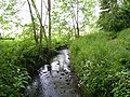 Wom Brook at the Rookery footbridge, close to the eastern end of the walk. |
|
| Location | |
| Village Village A village is a clustered human settlement or community, larger than a hamlet with the population ranging from a few hundred to a few thousand , Though often located in rural areas, the term urban village is also applied to certain urban neighbourhoods, such as the West Village in Manhattan, New... : |
Wombourne Wombourne Wombourne is a very large village and civil parish located in the district of South Staffordshire, in the county of Staffordshire, 4 miles south-west of Wolverhampton. Local affairs are run by a parish council. At the 2001 census it had a population of 13,691... |
| County County A county is a jurisdiction of local government in certain modern nations. Historically in mainland Europe, the original French term, comté, and its equivalents in other languages denoted a jurisdiction under the sovereignty of a count A county is a jurisdiction of local government in certain... : |
Staffordshire Staffordshire Staffordshire is a landlocked county in the West Midlands region of England. For Eurostat purposes, the county is a NUTS 3 region and is one of four counties or unitary districts that comprise the "Shropshire and Staffordshire" NUTS 2 region. Part of the National Forest lies within its borders... |
| Country Country A country is a region legally identified as a distinct entity in political geography. A country may be an independent sovereign state or one that is occupied by another state, as a non-sovereign or formerly sovereign political division, or a geographic region associated with a previously... : |
England England England is a country that is part of the United Kingdom. It shares land borders with Scotland to the north and Wales to the west; the Irish Sea is to the north west, the Celtic Sea to the south west, with the North Sea to the east and the English Channel to the south separating it from continental... , U.K. |
| Wom Brook Walk | |
| Length: | 1.5 miles (2.6km) |
| Status: | Local Nature Reserve Local Nature Reserve Local nature reserve or LNR is a designation for nature reserves in the United Kingdom. The designation has its origin in the recommendations of the Wild Life Conservation Special Committee which established the framework for nature conservation in the United Kingdom and suggested a national suite... |
| Established: | 2004 |
| Awards: | Green Flag Award Green Flag Award The Green Flag Award is the benchmark national standard for parks and green spaces in the United Kingdom. The scheme was set up in 1996 to recognise and reward green spaces in England and Wales that met the laid down high standards... |
| Administration | |
| Administrative authority: | South Staffordshire District Council |
| Groups: | Friends of Wom Brook |
The Wom Brook is a stream/brook
Stream
A stream is a body of water with a current, confined within a bed and stream banks. Depending on its locale or certain characteristics, a stream may be referred to as a branch, brook, beck, burn, creek, "crick", gill , kill, lick, rill, river, syke, bayou, rivulet, streamage, wash, run or...
located within South Staffordshire
South Staffordshire
South Staffordshire is a local government district in Staffordshire, England. The district lies to the north and west of Wolverhampton and the West Midlands, bordering Shropshire to the west and Worcestershire to the south...
, England
England
England is a country that is part of the United Kingdom. It shares land borders with Scotland to the north and Wales to the west; the Irish Sea is to the north west, the Celtic Sea to the south west, with the North Sea to the east and the English Channel to the south separating it from continental...
. It flows through the large village of Wombourne
Wombourne
Wombourne is a very large village and civil parish located in the district of South Staffordshire, in the county of Staffordshire, 4 miles south-west of Wolverhampton. Local affairs are run by a parish council. At the 2001 census it had a population of 13,691...
, and has played an important part in its industrial history. It is an important tributary of the River Smestow and part of the Severn catchment.
Etymology
The name of the stream is probably a back-formation from the name of the village of Wombourn or Wombourne. The word burna was used for a stream in the oldest strata of Old English toponyms. The village name was long thought to mean "Womb Stream", or stream in a hollow, because this is a reasonable description of the situation. More recently the interpretation Crooked Stream, has gained favour.The stream itself is not named in Domesday and medieval documents relating to the village. However, to turn the first element in the village name into a designation for the stream was logical and the Wom Brook is so-named on Ordnance Survey maps, although not on earlier maps. The Old English term brōca, another word for a stream, is later than burna and its derivative, brook, continues in use as a common noun in the English Midlands, while burn
Burn
A burn is an injury to flesh caused by heat, electricity, chemicals, light, radiation, or friction.Burn may also refer to:*Combustion*Burn , type of watercourses so named in Scotland and north-eastern England...
has become confined to Scotland and Northern England. This makes it fairly certain the name Wom Brook is of considerably later origin than the village name. Occasionally it is found in elided form as Wombrook.
Course
The name Wom Brook is generally applied to a stream that emerges from the pools at the WodehouseThe Wodehouse
The Wodehouse is a country house near Wombourne, Staffordshire, notable as the seat of the Georgian landscape designer and musicologist Sir Samuel Hellier and, a century later, Colonel Thomas Bradney Shaw-Hellier, director of the Royal Military School of Music. For almost 200 years the family...
- the product of the confluence of the Penn Brook, the Lyden Brook and other streams that drain water from the Colton Hills on the southern fringe of Wolverhampton
Wolverhampton
Wolverhampton is a city and metropolitan borough in the West Midlands, England. For Eurostat purposes Walsall and Wolverhampton is a NUTS 3 region and is one of five boroughs or unitary districts that comprise the "West Midlands" NUTS 2 region...
. Flowing south-west, it goes beneath both A449 and the older Stafford-Worcester road that runs alongside it, emerging at the edege of the village of Wombourne
Wombourne
Wombourne is a very large village and civil parish located in the district of South Staffordshire, in the county of Staffordshire, 4 miles south-west of Wolverhampton. Local affairs are run by a parish council. At the 2001 census it had a population of 13,691...
. At this point the Wom Brook Walk, a Local Nature Reserve
Local Nature Reserve
Local nature reserve or LNR is a designation for nature reserves in the United Kingdom. The designation has its origin in the recommendations of the Wild Life Conservation Special Committee which established the framework for nature conservation in the United Kingdom and suggested a national suite...
begins.
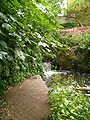
The stream is soon interrupted by the Pool Dam, the remains of a forge
Forge
A forge is a hearth used for forging. The term "forge" can also refer to the workplace of a smith or a blacksmith, although the term smithy is then more commonly used.The basic smithy contains a forge, also known as a hearth, for heating metals...
mill, where it tumbles steeply to the lower level. Passing just south of the village centre and behind the Civic Centre, it arrives at Lower End, the site of another former mill, where it passes under a road. The banks then open out into Ham Meadow, an area of grassland and trees. Flowing under the South Staffordshire Railway Walk
South Staffordshire Railway Walk
The South Staffordshire Railway Walk is located in Staffordshire, EnglandIt runs for five and a half miles [about 8.85km] from Castlecroft to Wall Heath.-History:...
and dropping again, the Wom enters the wooded Giggetty section, where it meanders through trees well below the level of the nearby housing.
Beyond Giggetty, the Wom disappears briefly into a culvert beneath a road and the Staffordshire and Worcestershire Canal
Staffordshire and Worcestershire Canal
The Staffordshire and Worcestershire Canal is a narrow navigable canal in the English Midlands, passing through the counties of Staffordshire and Worcestershire....
. Walkers take a short detour to find the brook flowing out from the culvert across the road at Longford, still a hazard to motorists after heavy rain. Immediately after comes the confluence with the Merryhill Brook, which joins the Wom next to Tyre Hill, the remains of a disused quarry. The brook flows through the Poolhouse estate, on the site of the former Heath Mill complex. Disappearing under the Bridgnorth
Bridgnorth
Bridgnorth is a town in Shropshire, England, along the Severn Valley. It is split into Low Town and High Town, named on account of their elevations relative to the River Severn, which separates the upper town on the right bank from the lower on the left...
road, it then flows through an area of industrial estates, finally discharging into the River Smestow directly opposite the village of Smestow.
History
From the Middle Ages, the Smestow, the Stour
River Stour, Worcestershire
The Stour is a river flowing through the counties of Worcestershire, the West Midlands and Staffordshire in the West Midlands region of England. The Stour is a major tributary of the River Severn, and it is about in length...
and their tributaries were the home of a thriving iron industry. By the 17th century, when civil and colonial strife greatly increased the demand for iron, this industry used overshot watermills to drive simple machinery for hammering, rolling, cutting, slitting and sharpening iron, smelted with local supplies of charcoal
Charcoal
Charcoal is the dark grey residue consisting of carbon, and any remaining ash, obtained by removing water and other volatile constituents from animal and vegetation substances. Charcoal is usually produced by slow pyrolysis, the heating of wood or other substances in the absence of oxygen...
. This required considerable investment, as well as political and legal influence, as weirs or dams, and often small canals, had to be constructed to maintain a sufficient head of water. Well before 1700, there was a development of considerable enterprises, under wealthy and powerful iron-masters, who sought to control the local market through the forming of cartels. The development of coke-fired furnaces in the Industrial Revolution greatly stimulated iron-working along the Wom and other streams in the area, while the construction of the Staffordshire and Worcestershire Canal
Staffordshire and Worcestershire Canal
The Staffordshire and Worcestershire Canal is a narrow navigable canal in the English Midlands, passing through the counties of Staffordshire and Worcestershire....
in 1770-72 made it easy to transport both raw materials and finished products in bulk.
The 1775 Yates map of Staffordshire shows three important mills on the Wom: at the Wodehouse
The Wodehouse
The Wodehouse is a country house near Wombourne, Staffordshire, notable as the seat of the Georgian landscape designer and musicologist Sir Samuel Hellier and, a century later, Colonel Thomas Bradney Shaw-Hellier, director of the Royal Military School of Music. For almost 200 years the family...
, at what is now called Pool Dam and Heath Forge, near the confluence with the Smestow - the beginning of the Heath Mill complex. The pools that regularised the flow at the Wodehouse were already well-developed by this stage, providing a both a steady power source and a striking landscape feature for the estate of the influential Hellier family. There had been a large watermill
Watermill
A watermill is a structure that uses a water wheel or turbine to drive a mechanical process such as flour, lumber or textile production, or metal shaping .- History :...
at the Wodehouse since at least 1570, and it has been used for fulling
Fulling
Fulling or tucking or walking is a step in woolen clothmaking which involves the cleansing of cloth to eliminate oils, dirt, and other impurities, and making it thicker. The worker who does the job is a fuller, tucker, or walker...
as well as grinding corn. The present building dates back to 1840.
In the 17th century, the Smestow had been divided north of Seisdon
Seisdon
Seisdon is a rural village in the county of Staffordshire approximately six miles west of Wolverhampton.-Etymology:The name appears to mean "hill of the Saxons", deriving from the Anglo-Saxon words Seis meaning Saxon and Dun meaning hill.-History:...
and a stream diverted left from the main river. Channelled by embankments, it reinforced the flow on the lower Wom, creating a mill pond
Mill pond
A mill pond is any body of water used as a reservoir for a water-powered mill. Mill ponds were often created through the construction of a mill dam across a waterway. In many places, the common proper name Mill Pond name has remained even though the mill has long since gone...
with a substantial drop to power the Heath Mill. Around the turn of the 19th century, the Heath Mill was developed further. The mill pool was greatly enlarged by diverting the Merryhill Brook into it, and it had to be held back by a large embankment above the small valley of the Wom. A large waterfall carried its water down to the Wom, where it powered a number of mills. A building at the pool-side, now long gone, gives its name to the large Poolhouse estate, on the western side of Wombourne and to a farm just beyond the village edge. The mill-owners, a branch of the Foley family, grew rich and constructed a large house above the Wom. The main mill was switched to grinding corn in the 1820s and continued in use for more than a further century.
The mid-19th century marked the zenith of Wombourne's contribution to the Industrial Revolution
Industrial Revolution
The Industrial Revolution was a period from the 18th to the 19th century where major changes in agriculture, manufacturing, mining, transportation, and technology had a profound effect on the social, economic and cultural conditions of the times...
, with many of the adult population involved in nail-making a similar trades. The 1889 OS map shows a smithy close to the Pool Dam, one of the many small iron-working concerns that used the Wom for power or cooling water, as well as the larger developments at the Wodhouse and Heath. By this time, the latter used the Wom not only for power, but also to supply watercress
Watercress
Watercresses are fast-growing, aquatic or semi-aquatic, perennial plants native from Europe to central Asia, and one of the oldest known leaf vegetables consumed by human beings...
beds and fish ponds. Millhouse Farm, close to Lower End, had grown up next to yet another mill close to the village centre.
From the mid-19th century, water power lost its importance as coal-powered steam engines became more reliable, and coal transported by the canal became more economic as a fuel. The Wom Brook lost its industrial importance long before the village of Wombourne. The mills returned to grinding corn before closing entirely and falling into neglect. With the decline of heavy industry in the West Midlands region during the 20th century, Wombourne itself became a residential and light industrial centre. Housing spread on both sides of the brook to the west of the village centre, and industrial estates along the lower course, down to the confluence with the Smestow, but the threat of flooding preserved a green corridor. Wildlife was able to re-establish and the Wom has thus taken on a new importance as a leisure and environmental amenity. The Wom Brook Walk was established in 2004 by the Friends of Wom Brook and was made a Local Nature Reserve
Local Nature Reserve
Local nature reserve or LNR is a designation for nature reserves in the United Kingdom. The designation has its origin in the recommendations of the Wild Life Conservation Special Committee which established the framework for nature conservation in the United Kingdom and suggested a national suite...
in 2008.
Wom Brook Walk
Local Nature Reserve
Local nature reserve or LNR is a designation for nature reserves in the United Kingdom. The designation has its origin in the recommendations of the Wild Life Conservation Special Committee which established the framework for nature conservation in the United Kingdom and suggested a national suite...
in 2008, it received a Green Flag Award
Green Flag Award
The Green Flag Award is the benchmark national standard for parks and green spaces in the United Kingdom. The scheme was set up in 1996 to recognise and reward green spaces in England and Wales that met the laid down high standards...
.
Starting off on the western edge of Wombourne
Wombourne
Wombourne is a very large village and civil parish located in the district of South Staffordshire, in the county of Staffordshire, 4 miles south-west of Wolverhampton. Local affairs are run by a parish council. At the 2001 census it had a population of 13,691...
near the Pool House estate the walks begins in a small woodland before eventually opening up into grass land with mature trees such as Oak and Willow.
The walk runs through a housing estate, although in a small valley. Just before the Longford, walkers can cross or linger on a small bridge, modelled on the Poohsticks
Poohsticks
Poohsticks is a game first mentioned in The House at Pooh Corner, a Winnie-the-Pooh book by A. A. Milne. It is a simple game which may be played on any bridge over running water; each player drops a stick on the upstream side of a bridge and the one whose stick first appears on the downstream side...
bridge in Ashdown Forest
Ashdown Forest
Ashdown Forest is an ancient area of tranquil open heathland occupying the highest sandy ridge-top of the High Weald Area of Outstanding Natural Beauty. It is situated some south of London in the county of East Sussex, England...
. Beyond the Longford, walkers are required to make a short diversion over the canal via a pavement to the Giggetty section. This consists of scrub land and wooded banks, with the stream meandering under trees over a gravel bed.
The walk is then intersected by the South Staffordshire Railway Walk
South Staffordshire Railway Walk
The South Staffordshire Railway Walk is located in Staffordshire, EnglandIt runs for five and a half miles [about 8.85km] from Castlecroft to Wall Heath.-History:...
, and walkers must ascend and descend a series of paths to resume their way along the stream banks. This opens up the Wombourne Village West section, which initially goes through Ham Meadow. This is an undulating open area, close to the village centre. The meandering stream has cut a steep-sided valley through the meadow, flanked by trees.
At Lower End, walkers cross the road into the Wombourne Village east section, with a mixture of open grassy areas, giving views of the village centre, and denser woodland
Woodland
Ecologically, a woodland is a low-density forest forming open habitats with plenty of sunlight and limited shade. Woodlands may support an understory of shrubs and herbaceous plants including grasses. Woodland may form a transition to shrubland under drier conditions or during early stages of...
. Here it is possible divert a little from the path to descend to the foot of the Pool Dam, the site of an old forge
Forge
A forge is a hearth used for forging. The term "forge" can also refer to the workplace of a smith or a blacksmith, although the term smithy is then more commonly used.The basic smithy contains a forge, also known as a hearth, for heating metals...
mill
Watermill
A watermill is a structure that uses a water wheel or turbine to drive a mechanical process such as flour, lumber or textile production, or metal shaping .- History :...
. Finally, the eastern end of the walk is found near Rushford Bridge, which crosses the old Stafford-Worcester Road, now in the shadow of the modern A449 dual-carriageway.
The Walk is also contained entirely within the boundaries of the village of Wombourne
Wombourne
Wombourne is a very large village and civil parish located in the district of South Staffordshire, in the county of Staffordshire, 4 miles south-west of Wolverhampton. Local affairs are run by a parish council. At the 2001 census it had a population of 13,691...
where parking is to be found. In recent years, signs have been erected at all intersections to indicate the route, and there are information boards at many points to indicate important points of local and industrial history. The whole of the walk is accessible to wheelchair users, although the intersection with the railway walk involves steep slopes.
Wildlife
In 2005 the Staffordshire Wildlife Trust completed a survey, which found an active colony of water voles.The wildlife of Wom Brook includes Kingfishers, Dippers
White-throated Dipper
The White-throated Dipper , also known as the European Dipper or just Dipper is an aquatic passerine bird found in Europe, Middle East, Central Asia and the Indian Subcontinent. The species is divided into several subspecies, based primarily on colour differences, particularly of the pectoral band...
and the fast declining Water Vole along with more common species such as Grey Herons
Grey Heron
The Grey Heron , is a wading bird of the heron family Ardeidae, native throughout temperate Europe and Asia and also parts of Africa. It is resident in the milder south and west, but many birds retreat in winter from the ice in colder regions...
, Long-eared bats, Green Woodpeckers
Green Woodpecker
The European Green Woodpecker is a member of the woodpecker family Picidae. There are four subspecies and it occurs in most parts of Europe and in western Asia...
, Bees and Butterflies. There has also been great excitement over the arrival of Wombourne's very first Little Egret in October/November 2010. It was seen hunting and roosting around the Wombrook on a number of occasions and Daniel Traynor captured the very first image of the bird which was later shown in the Parish News. .
Tributaries
The main tributaries of the Wom Brook, starting from its confluence with the River Smestow, are:- The Merryhill Brook. This originates on the western edge of the Colton Hills in Upper PennPenn, West MidlandsPenn is an area now divided between Wolverhampton in the West Midlands and South Staffordshire. Originally, it was a village in the historic county of Staffordshire. There is considerable confusion about exactly which areas fall within Penn...
, within Wolverhampton. Disappearing sometimes into culverts, it runs west and out of the city through the suburb of Merry HillMerry Hill, WolverhamptonMerry Hill is a suburb of Wolverhampton, West Midlands and a ward of Wolverhampton City Council. It is situated in the south-west of the city, bordering South Staffordshire and the Tettenhall Wightwick, Park, Graiseley and Penn wards...
. Subject to flooding because of the impermeable clay soils of the plateau, it feeds into a storm water reservoir, before continuing westward to Dimmingsdale, on the Staffordshire and Worcestershire CanalStaffordshire and Worcestershire CanalThe Staffordshire and Worcestershire Canal is a narrow navigable canal in the English Midlands, passing through the counties of Staffordshire and Worcestershire....
. Here it turns south and roughly follows the course of the canal, meandering out into farmland, until it passes under the canal just south of the BratchBratchThe Bratch is an area of Wombourne in Southern Staffordshire, England, noted for its industrial heritage and as a way station for walkers, riders and cyclists...
. It then runs alongside the canal, on its western side, disappearing briefly into a culvert, until it flows into the Wom Brook just below Longford.
- The Lyden Brook. This is one of a number of brooks which drain the area around Lloyd House, south of Wolverhampton. All flow south into the Wodehouse mill pool.
- The Penn Brook. This is essentially the upper course of the Wom Brook. The distinction between the two is artificial, as the Wom Brook simply continues the course of the Penn Brook beyond the pools at the WodehouseThe WodehouseThe Wodehouse is a country house near Wombourne, Staffordshire, notable as the seat of the Georgian landscape designer and musicologist Sir Samuel Hellier and, a century later, Colonel Thomas Bradney Shaw-Hellier, director of the Royal Military School of Music. For almost 200 years the family...
, which it feeds. The Penn Brook is fed by streams running down from the eastern and southern slopes of the Colton Hills on the edge of Wolverhampton. It originates by Park Hall at Goldthorn ParkGoldthorn ParkGoldthorn Park is a suburb of Wolverhampton, West Midlands. It is situated to the south of the city centre within the Blakenhall ward.It mostly consists of nearly 2,000 private houses built in the 1920s and 1930s housing...
. It runs east and south along the edge of SedgeleySedgeleySedgeley was a mansion, designed by architect Benjamin Henry Latrobe, and built on the east banks of the Schuylkill River in Philadelphia in 1799-1802.-Design and construction:...
, before turning west, across Penn Common. This area is naturally very wet and has been made usable by centuries of management and improvement of the watercourses that run across it. In Victorian times it accommodated a race course, but today it is occupied by a golf course and farmland. The brook passes the old Penn Brewery, which it once supplied with water and power: today it is the Lloyd Roberts Building, an apartment block. It then flows into the mill pool, north of the Wodehouse, where it loses its identity.
For about three centuries, the River Smestow was also a tributary of its own tributary, the Wom Brook. Channels were taken from the Smestow in the Seisdon
Seisdon
Seisdon is a rural village in the county of Staffordshire approximately six miles west of Wolverhampton.-Etymology:The name appears to mean "hill of the Saxons", deriving from the Anglo-Saxon words Seis meaning Saxon and Dun meaning hill.-History:...
and Trysull
Trysull
Trysull is a village situated in Staffordshire, England. It is situated within the South Staffordshire District, having been part of Seisdon Rural District until 1974....
areas to feed various mills and pools. One of these, a small contour canal
Contour canal
A contour canal is an artificially-dug navigable canal which closely follows the contour line of the land it traverses in order to avoid costly engineering works such as boring a tunnel through higher ground, building an embankment over lower ground, or constructing a canal lock to change the...
, led from just north of Trysull to Heath Mill. Here it fed a very large mill pool, which was also supplied by a similar channel from further up the Wom Brook. The purpose of this scheme was probably to avoid flooding or reduction of the head of water further up the Wom Brook. These were always fertile sources of legal and political dispute among users of streams in the early modern period. The result was a large waterfall, providing a reliable source of power for the mill, which continued grinding corn until the 1930s. The channel and pool fell into disuse and were later filled in, although the route is still traceable as the main public footpath from Wombourne to Trysull.