
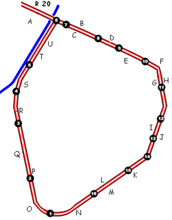
.gif)
Small ring (Brussels)
Encyclopedia
| R20 Brussels Small Ring |
||||||||||||||||||||||||||||||||||||
| Length: 8 km | ||||||||||||||||||||||||||||||||||||
 |
||||||||||||||||||||||||||||||||||||
| Intersections | ||||||||||||||||||||||||||||||||||||
EWLINE
|
||||||||||||||||||||||||||||||||||||
 (1)
(1)

Brussels
Brussels , officially the Brussels Region or Brussels-Capital Region , is the capital of Belgium and the de facto capital of the European Union...
, Belgium
Belgium
Belgium , officially the Kingdom of Belgium, is a federal state in Western Europe. It is a founding member of the European Union and hosts the EU's headquarters, and those of several other major international organisations such as NATO.Belgium is also a member of, or affiliated to, many...
, surrounding the historic city centre. It was built on the site of the Second walls of Brussels
Second walls of Brussels
There were two stages of fortifications of Brussels, the first walls, built in the early 13th century, and the second walls, built in the late 14th century and later upgraded. Today, only a few sections of either remain.-First walls:...
, built in the 16th century, after they were torn down.
The small ring and the area within it are often called the pentagon
Pentagon
In geometry, a pentagon is any five-sided polygon. A pentagon may be simple or self-intersecting. The sum of the internal angles in a simple pentagon is 540°. A pentagram is an example of a self-intersecting pentagon.- Regular pentagons :In a regular pentagon, all sides are equal in length and...
, as it has a pentagonal shape. The small ring is about 8 km long. It is surrounded by the Greater Ring
Greater ring (Brussels)
The Greater Ring in Brussels, Belgium is a set of roads in the shape of a ring, intermediate between the small ring and the main Brussels ring...
, which runs about 30 km and by the Ring
Brussels Ring
The Brussels Ring numbered R0, is a ring road surrounding the city of Brussels as well as other smaller towns south of Brussels. The road is a circular highway road of about 75 km with 2 to 3 lanes in each direction...
(about 80 km).
During the second stage of the covering of the Senne
Covering of the Senne
The covering of the Senne was one of the defining events in the history of Brussels. The Senne/Zenne was historically the main waterway of Brussels, but it became more polluted and less navigable as the city grew. By the second half of the 19th century, it had become a serious health hazard and...
in the 20th century, the river was diverted to underneath the western boulevards of the ring. This freed up the main tunnels that had contained the water to allow construction of the Brussels premetro with minimal disruption of the surface.
The road passes through tunnels allowing vehicles to avoid traffic lights that regulate the circulation at surface level. Thus, it is possible to travel from the Brussels-South railway station to the Place Sainctelette/Saincteletteplein (via Arts-Loi), and even further to the Basilica, or the reverse route, through tunnels without having to stop at traffic lights. The section of the small ring between the Place Sainctelette and the south station via the Anderlecht gate is completely at surface-level and is subsequently slower to travel along.
History
In the 16th century, Brussels had a second set of defensive wallsSecond walls of Brussels
There were two stages of fortifications of Brussels, the first walls, built in the early 13th century, and the second walls, built in the late 14th century and later upgraded. Today, only a few sections of either remain.-First walls:...
built to accommodate the expanding city. There were eight gates built along its length, many of which give their names to squares and intersections along the course of the road.
The walls proved fairly useless in combat, not able to prevent either the French bombardment of Brussels
Bombardment of Brussels
The bombardment of Brussels by French troops of King Louis XIV on August 13, 14 and 15, 1695 and the resulting fire were together the most destructive event in the entire history of Brussels. The Grand Place was destroyed, along with a third of the buildings in the city...
in 1695, or French troops from seizing the city
Siege of Brussels
The Siege of Brussels took place between January and February 1746 during the War of the Austrian Succession. A French army under the overall command of Maurice de Saxe besieged and captured the city of Brussels, which was then the capital of the Austrian Netherlands, from its Austrian garrison.The...
in 1746 as part of the War of the Austrian Succession
War of the Austrian Succession
The War of the Austrian Succession – including King George's War in North America, the Anglo-Spanish War of Jenkins' Ear, and two of the three Silesian wars – involved most of the powers of Europe over the question of Maria Theresa's succession to the realms of the House of Habsburg.The...
. After the latter, the defensive works were in ruins. By that time, siege was no longer as important a part of warfare. Due to the growth of commerce and roads, it was found that the fortifications did little more than frustrate transit into and out of the city.
In 1782, Emperor Joseph II
Joseph II, Holy Roman Emperor
Joseph II was Holy Roman Emperor from 1765 to 1790 and ruler of the Habsburg lands from 1780 to 1790. He was the eldest son of Empress Maria Theresa and her husband, Francis I...
ordered the dismantling of most fortifications in the Low Countries
Low Countries
The Low Countries are the historical lands around the low-lying delta of the Rhine, Scheldt, and Meuse rivers, including the modern countries of Belgium, the Netherlands, Luxembourg and parts of northern France and western Germany....
, including those of Brussels. The dismantling work of the exterior defences began in the east of the city. In 1795, when Republican France invaded and annex
Annexation
Annexation is the de jure incorporation of some territory into another geo-political entity . Usually, it is implied that the territory and population being annexed is the smaller, more peripheral, and weaker of the two merging entities, barring physical size...
ed the Low Countries, the demolitions were stopped, not resuming until an order from Napoleon in 1804. Laeken Gate was destroyed in 1808. By an ordinance
Ordonnance (French constitutional law)
In the Government of France, an ordonnance is a statute passed by the Council of Ministers in an area of law normally reserved for statute law passed by the Parliament of France....
on May 19, 1810, the French Emperor ordered the second walls demolished and replaced by boulevards with a median
Central reservation
On divided roads, such as divided highways or freeways/motorways, the central reservation , median, parkway , median strip or central nature strip is the area which separates opposing lanes of traffic...
in the centre. The fall of the First French Empire
First French Empire
The First French Empire , also known as the Greater French Empire or Napoleonic Empire, was the empire of Napoleon I of France...
prevented the project's immediate execution.
With the return of stability, in 1818, authorities organized a contest for plans to demolish the ramparts and replace them with boulevards suited to the exigencies of contemporary life in the city. The proposal of Jean-Baptiste Vifquain was ultimately chosen. It involved construction of squares
Town square
A town square is an open public space commonly found in the heart of a traditional town used for community gatherings. Other names for town square are civic center, city square, urban square, market square, public square, and town green.Most town squares are hardscapes suitable for open markets,...
and boulevards, with spaces to walk and two to four rows of trees lining the route, a main road and parallel side roads. A barrier with a ditch running its length was still installed, however, and customs houses built at the entrances, to allow continued taxation of commercial goods entering the city. The work was to be financed by selling the land that was freed up, although this took over 20 years to do.
In the 1950s, with pressure from the automobile
Automobile
An automobile, autocar, motor car or car is a wheeled motor vehicle used for transporting passengers, which also carries its own engine or motor...
, new plans to improve traffic flow were implemented, partly due to the 1958 World's Fair
Expo '58
Expo 58, also known as the Brussels World’s Fair, Brusselse Wereldtentoonstelling or Exposition Universelle et Internationale de Bruxelles, was held from 17 April to 19 October 1958...
. Later, tunnels were dug, and one of the main lines of the Brussels Metro
Brussels Metro
The Brussels Metro is a rapid transit system serving a large part of the Brussels-Capital Region of Belgium. It consists of a network with four metro line services with some shared sections. The metro has 49.9 km of network and 59 stations...
now runs primarily underneath the small ring.
Ring 20
All ring roadRing road
A ring road, orbital motorway, beltway, circumferential highway, or loop highway is a road that encircles a town or city...
s in Belgium bear the name ring. Brussels has three ring roads: Ring 0
Brussels Ring
The Brussels Ring numbered R0, is a ring road surrounding the city of Brussels as well as other smaller towns south of Brussels. The road is a circular highway road of about 75 km with 2 to 3 lanes in each direction...
that surroundss the agglomeration, Ring 21
Greater ring (Brussels)
The Greater Ring in Brussels, Belgium is a set of roads in the shape of a ring, intermediate between the small ring and the main Brussels ring...
that is intermediate, and Ring 20, the innermost, comprises the small ring, with an extension along boulevard Léopold II/Leopold II laan and avenue Charles Quint/Karel de Vijfdelaan, all the way to R0.
Roads that make up the small ring
The small ring is actually composed of a set of roads that form a pentagon, or ring.- A – Boulevard Léopold II / Leopold II laan
- B – Boulevard Baudouin / Boudewijnlaan
- C – Boulevard d'Anvers / Antwerpselaan
- D – Avenue du Boulevard / Boulevardlaan
- E – Boulevard du Jardin Botanique / Kruidtuinlaan
- F – Avenue Galilée / Galiléelaan
- G – Boulevard Bisschoffsheim / Bisschoffsheimlaan
- H – Avenue de l’Astronomie / Sterrenkundelaan
- I – Boulevard du Régent / Regentlaan
- J – Avenue des Arts / Kunstlaan
- K – Avenue Marnix / Marnixlaan
- L – Boulevard de Waterloo / Waterloolaan
- M – Avenue de la Toison d’Or / Guldenvlieslaan
- N – Avenue Henri Jaspar / Henri Jasparlaan
- O – Avenue de la Porte de Hal / Hallepoortlaan
- P – Boulevard du Midi / Zuidlaan
- Q – Boulevard Poincaré / Poincarélaan
- R – Boulevard de l’Abattoir / Slachthuislaan
- S – Boulevard Barthélemy / Barthélémylaan
- T – Boulevard de Nieuport / Nieuwpoortlaan
- U – Boulevard du 9e de Ligne / 9de Linielaan
Crossroads
The small ring also crosses a lot of main roads leading to other towns. Some of those crossroads are located next to former gates of the second walls of Brussels and are named after those gates, for instance Porte de Namur/Naamsepoort. On top of the 7 gates of the second walls, some of the gates were built later on to collect taxes at important crossroads, among which the Porte de Ninove/Ninoofsepoort and the Porte d'Anvers/Antwerpsepoort. The only gate to remain is the Porte de Hal/HallepoortHalle Gate
The Porte de Hal or Hallepoort is a medieval fortified city gate of the second walls of Brussels.Built in 1381, Halle Gate is a 14th century city gate from the second set of defensive walls that enclosed Brussels. The gate was named for the city of Halle in Flemish Brabant which it faces.The...
, while at Porte d'Anderlecht/Anderlechtsepoort and at Porte de Ninove/Ninoofsepoort some buildings from the former gate remain.
Starting from the north-east of the small ring, place Sainctelette, and going clockwise, the ring crosses successively:
- the Willebroeck CanalBrussels-Scheldt Maritime CanalThe Brussels–Scheldt Maritime Canal, also named the Willebroek Canal, is a canal in Belgium linking Brussels with the river Scheldt. The canal was known as the Brussels-Rupel Maritime Canal, prior to the establishment of a direct link with the Scheldt in 1997.The canal is one of the oldest...
at Place Sainctelette/Saincteletteplein - the Quai de Willebroek /Willebroekkaai at Place de l'Yser/IJzerplein
- the Chaussée d'Anvers/Antwerpsesteenweg (N1 roadN1 road (Belgium)The N1 is a road connecting Brussels and Antwerp....
) at Porte d'Anvers/Antwerpsepoort, leading to BredaBredaBreda is a municipality and a city in the southern part of the Netherlands. The name Breda derived from brede Aa and refers to the confluence of the rivers Mark and Aa. As a fortified city, the city was of strategic military and political significance...
via MechelenMechelenMechelen Footnote: Mechelen became known in English as 'Mechlin' from which the adjective 'Mechlinian' is derived...
and Antwerp - the Rue du Progrès/Vooruitgangstraat at Place Rogier/Rogierplein
- the Rue Royale/Koningsstraat at Porte de Schaerbeek/Schaarbeeksepoort
- the Chaussée de Louvain/Leuvensesteenweg (N2 roadN2 road (Belgium)The N2 road in Belgium is a road connecting Brussels and Maastricht passing Leuven, Diest and Hasselt. It starts in Brussels at the Madou crossroad on the small ring, heading northeast as the Chaussée de Louvain/Leuvensesteenweg, which crosses the municipalities of Saint-Josse-ten-Noode, City of...
) at Place Madou/Madouplein, leading to MaastrichtMaastrichtMaastricht is situated on both sides of the Meuse river in the south-eastern part of the Netherlands, on the Belgian border and near the German border...
via LeuvenLeuvenLeuven is the capital of the province of Flemish Brabant in the Flemish Region, Belgium...
and HasseltHasseltHasselt is a Belgian city and municipality, and capital of the Flemish province of Limburg... - the Rue de la Loi/Wetstraat (N3 roadN3 road (Belgium)The N3 road in Belgium is a national road connecting the capital city Brussels to Aachen in Germany via Leuven, Tienen, Sint-Truiden and Liège. Its course is quite similar to that of European route E40 between Brussels and Aachen, which it intersects 3 times...
) at Arts-Loi/Kunst-Wet, leading to AachenAachenAachen has historically been a spa town in North Rhine-Westphalia, Germany. Aachen was a favoured residence of Charlemagne, and the place of coronation of the Kings of Germany. Geographically, Aachen is the westernmost town of Germany, located along its borders with Belgium and the Netherlands, ...
via TervurenTervurenTervuren is a municipality in the province of Flemish Brabant, in Flanders, one of the three regions of Belgium. The municipality comprises the villages of Duisburg, Tervuren, Vossem and Moorsel. On January 1, 2006, Tervuren had a total population of 20,636...
, LeuvenLeuvenLeuven is the capital of the province of Flemish Brabant in the Flemish Region, Belgium...
and LiègeLiègeLiège is a major city and municipality of Belgium located in the province of Liège, of which it is the economic capital, in Wallonia, the French-speaking region of Belgium.... - the Rue Belliard/Belliardstraat at Belliard
- the Rue du Trône/Troonstraat at Place du Trône/Troonplein
- the Chaussée de WavreChaussée de WavreThe Chaussée de Wavre or Waversesteenweg in Brussels, Belgium is a major street crossing the municipalities of Ixelles, Etterbeek and Auderghem...
(N4 roadN4 road (Belgium)Route Nationale 4 or the N4 road in Belgium is a highway that runs from Brussels to Luxembourg. It starts as chausée de Wavre at Porte de Namur on the Brussels inner ring and runs south east through Wavre and Namur, Marche, Bastogne, Martelange and Arlon before terminating as route de Luxembourg...
) at Porte de Namur/Naamsepoort, leading to LuxembourgLuxembourgLuxembourg , officially the Grand Duchy of Luxembourg , is a landlocked country in western Europe, bordered by Belgium, France, and Germany. It has two principal regions: the Oesling in the North as part of the Ardennes massif, and the Gutland in the south...
via WavreWavreWavre is a town and municipality located in the Belgian province of Walloon Brabant, of which it is the capital.Wavre is located in the Dyle valley. Most of its inhabitants speak French as mother tongue and are called "Wavriens" and "Wavriennes"...
, NamurNamur (city)Namur is a city and municipality in Wallonia, in southern Belgium. It is both the capital of the province of Namur and of Wallonia....
and Arlon - the Avenue Louise/Louizalaan at Place Louise/Louizaplein
- the Chaussée de Waterloo/Waterloosesteenweg (N5 roadN5 road (Belgium)The N5 is a road in Belgium connecting the small ring in Brussels and Philippeville via Charleroi....
) at Porte de Hal/HallepoortHalle GateThe Porte de Hal or Hallepoort is a medieval fortified city gate of the second walls of Brussels.Built in 1381, Halle Gate is a 14th century city gate from the second set of defensive walls that enclosed Brussels. The gate was named for the city of Halle in Flemish Brabant which it faces.The...
, leading to FranceFranceThe French Republic , The French Republic , The French Republic , (commonly known as France , is a unitary semi-presidential republic in Western Europe with several overseas territories and islands located on other continents and in the Indian, Pacific, and Atlantic oceans. Metropolitan France...
via WaterlooWaterloo, BelgiumWaterloo is a Walloon municipality located in the province of Walloon Brabant, Belgium. On December 31, 2009, Waterloo had a total population of 29,573. The total area is 21.03 km² which gives a population density of 1,407 inhabitants per km²...
, CharleroiCharleroiCharleroi is a city and a municipality of Wallonia, located in the province of Hainaut, Belgium. , the total population of Charleroi was 201,593. The metropolitan area, including the outer commuter zone, covers an area of and had a total population of 522,522 as of 1 January 2008, ranking it as...
and CouvinCouvinCouvin is a Walloon municipality and town located in Belgium in the province of Namur.On 1 January 2006 the municipality had 13,476 inhabitants. Couvin is the second largest municipality of Belgium by surface area, after Tournai... - the Avenue Fonsny/FonsnylaanAvenue FonsnyThe Avenue Fonsny or Fonsnylaan is a major street in the municipality of Saint-Gilles in Brussels, Belgium connecting the Place de la Constitution on the south-west of the small ring road to the municipality of Forest. It is continued in Forest by the Avenue Van Volxem. It runs parallel to the...
at the Brussels-South railway station - the Chaussée de Mons/Bergensesteenweg (N6 road) at Porte d'Anderlecht/Anderlechtsepoort, leading to MaubeugeMaubeugeMaubeuge is a commune in the Nord department in northern France.It is situated on both banks of the Sambre , east of Valenciennes and about from the Belgian border.-History:...
via HalleHalle, BelgiumHalle , is a Belgian city and municipality in the district Halle-Vilvoorde of the province Flemish Brabant. The city is located on the Brussels-Charleroi Canal and on the Flemish side of the language border that separates Flanders and Wallonia...
(where the N7 road starts towards LilleLilleLille is a city in northern France . It is the principal city of the Lille Métropole, the fourth-largest metropolitan area in the country behind those of Paris, Lyon and Marseille. Lille is situated on the Deûle River, near France's border with Belgium...
via TournaiTournaiTournai is a Walloon city and municipality of Belgium located 85 kilometres southwest of Brussels, on the river Scheldt, in the province of Hainaut....
) and MonsMonsMons is a Walloon city and municipality located in the Belgian province of Hainaut, of which it is the capital. The Mons municipality includes the old communes of Cuesmes, Flénu, Ghlin, Hyon, Nimy, Obourg, Baudour , Jemappes, Ciply, Harmignies, Harveng, Havré, Maisières, Mesvin, Nouvelles,... - the Chaussée de Ninove/Ninoofsesteenweg (N8 roadN8 road (Belgium)The N8 road in Belgium is a road connecting Brussels and Koksijde, passing Ninove, Oudenaarde, Kortrijk, Ypres and Veurne....
) at Porte de Ninove/Ninoofsepoort, leading to KoksijdeKoksijdeKoksijde is a municipality located in the Flemish province of West Flanders on the North Sea coast, at the southwest side. It comprises the towns of Koksijde proper, Oostduinkerke, St-Idesbald and Wulpen.-Statistics:...
via NinoveNinoveNinove is a city and municipality located in Flanders, one of the three regions of Belgium, and in the Flemish province of East Flanders in the Denderstreek. It is situated on the river Dender...
, OudenaardeOudenaardeOudenaarde is a Belgian municipality in the Flemish province of East Flanders. The municipality comprises the city of Oudenaarde proper and the towns of Bevere, Edelare, Eine, Ename, Heurne, Leupegem, Mater, Melden, Mullem, Nederename, Welden, Volkegem and a part of Ooike.From the 15th to the 18th...
and KortrijkKortrijkKortrijk ; , ; ) is a Belgian city and municipality located in the Flemish province West Flanders... - the Chaussée de Gand/Steenweg op Gent (N9 road) at Porte de Flandre/Vlaamsepoort, leading to OstendOstendOstend is a Belgian city and municipality located in the Flemish province of West Flanders. It comprises the boroughs of Mariakerke , Stene and Zandvoorde, and the city of Ostend proper – the largest on the Belgian coast....
via GhentGhentGhent is a city and a municipality located in the Flemish region of Belgium. It is the capital and biggest city of the East Flanders province. The city started as a settlement at the confluence of the Rivers Scheldt and Lys and in the Middle Ages became one of the largest and richest cities of...
and BruggeBrüggeBrügge is a municipality in the district of Rendsburg-Eckernförde, in Schleswig-Holstein, Germany.Its small church and market square are noted for their beauty....
Public transport
The Brussels metroBrussels Metro
The Brussels Metro is a rapid transit system serving a large part of the Brussels-Capital Region of Belgium. It consists of a network with four metro line services with some shared sections. The metro has 49.9 km of network and 59 stations...
operates under the small ring from the south station to Place Sainctelette via Arts-Loi while the section via the Anderlecht gate is not serviced by the metro. The latter section is though serviced by tram routes 51 from Lemonnier to Petit Château stops and 82 from Lemonnier to the Ninove gate. The bus route 86 drives for one stop on the small ring between the Ninove and Flanders gates. Between Rogier and Botanique, buses 61 also drives on the small ring as well as buses 34, 64 and 80 drive between the Namur gate and Trône.