
Sideling Hill
Encyclopedia
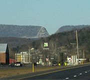
Sideling Hill is a long, steep, narrow mountain ridge in the Ridge-and-Valley
( or Allegheny Mountains
) physiographic province
of the Appalachian Mountains
, located in Washington County
in western Maryland
and adjacent West Virginia
and Pennsylvania
, USA
. The ridge's highest point, at 2301 feet (701.3 m), is in Fulton County, Pennsylvania
.
, in a region of downward-folded (synclinal) rock strata
between two upfolded anticline
s. The ridge is capped by an erosion-resistant
conglomerate
and sandstone
of Mississippian (early Carboniferous
) geologic age, the Purslane Sandstone of the Pocono Formation
. The ridge's slopes are formed of much more easily eroded kinds of rock, including the Devonian
-Mississippian Rockwell Formation
, with long, narrow valleys paralleling the ridge on either side.
tree species such as oaks (Quercus) and hickories (Carya), along with occasional evergreen
pines (Pinus).
constructed a tunnel
through Sideling Hill in 1873–74 as part of its mainline construction. The tunnel predates the South Pennsylvania Railroad
tunnel construction 11 miles (17.7 km) to the south by eight years. The tunnel is single-tracked, and curved at each end. It originally had a stone portal on its eastern (RR North) end and a natural stone portal at its western (RR South) end, but about 1919 the north portal was replaced with a concrete one.
The north portal was equipped with doors to prevent wind from blowing through the tunnel as the wind caused water percolating into the tunnel to freeze on the tracks in the winter. In 1911, this ice caused the brand new locomotive #12 to derail its pilot axle inside the tunnel then derail the entire locomotive at the Kimmel switch just beyond the tunnel. In the 1940s, the doors were equipped with remote actuators mounted on poles a few hundred feet before each portal. This allowed the crews to open and close the doors without stopping. The system did not work flawlessly and a door was ripped off by a caboose
cupola.
The tunnel was in service from 1874 until the railroad ceased operations in 1956. The line is technically out of service (but not abandoned), and the track is still in place through the tunnel, although not serviceable. The tunnel and rail line are private property and not open to the public.
(Interstate 76
) crosses Sideling Hill east of Breezewood, Pennsylvania
, bypassing the two-lane Sideling Hill tunnel and the nearby Rays Hill tunnel
that were formerly used by the Turnpike. Completed at a cost of $17,203,000, the Sideling Hill bypass opened on November 26, 1968.
 The Sideling Hill Tunnel
, through Sideling Hill in Pennsylvania
east of Breezewood
, is currently in its third phase of life. In the 1880s, a tunnel was partially bored through the mountain by the South Pennsylvania Railroad
. The railroad project ceased, and the tunnel was left abandoned. When construction of the Pennsylvania Turnpike
was begun in the 1930s by the Pennsylvania Turnpike Commission
on the right-of-way
of the old South Pennsylvania Railroad, the tunnel was completed for highway use by the Turnpike.
The tunnel, at 6782 feet (2,067.2 m) long the longest of the seven original Turnpike tunnels, was used from the Turnpike's opening in 1940 until 1968. Due to increasing traffic on the highway, the turnpike commission began upgrading all of its two-lane tunnels, constructing twin bores for its tunnels through the Allegheny, Tuscarora, Kittatinny, and Blue mountains, and bypassing the tunnels under Laurel Hill, Rays Hill, and Sideling Hill with new, four-lane highways climbing the adjacent hills. The Sideling Hill tunnel and the nearby Rays Hill tunnel
, along with connecting segments of four-lane highway, were used for many years as a testing facility for new highway technologies.
In 2001, the Sideling Hill Tunnel was sold to the Southern Alleghenies Conservancy
for $1, which now operates it as a bike trail.
 The Sideling Hill Road Cut
on Interstate 68
and U.S. 40
is a 340 feet (103.6 m) deep notch excavated from the ridge of Sideling Hill, about 7 miles (11 km) west of Hancock
in Washington County, Maryland
. It is notable as an impressive man-made mountain pass, visible from miles away, and is considered to be one of the best rock exposures in Maryland and the entire northeastern United States
. Almost 810 feet (246.9 m) of strata
in a tightly folded syncline
are exposed in this road cut. Although other exposures may surpass Sideling Hill in either thickness of exposed strata or in quality of geologic structure, few can equal its combination of both. The exposed rocks consist of the Devonian
-Mississippian Rockwell Formation
, underlying the Mississippian Purslane Sandstone
.
The rest stop formerly included the Sideling Hill Exhibit Center, a four-level geological museum and travel information center which opened in 1991. Due to state budget cuts, this facility was closed on Aug. 15, 2009, as part of a $280 million budget reduction package, saving the state about $110,000 annually. Before its closing, the center served about 95,000 visitors a year, at a cost of about $1.16 per visitor.
.
, the National Road
, crossed Sideling Hill with a steep grade on each side and a sharp hairpin turn
at the crest of the mountain.
cut through Sideling Hill by the Potomac River
southwest (upstream) of Hancock, Maryland
, provides a low-level crossing of the ridge for the CSX Railroad
(formerly the main line of the Baltimore and Ohio (B&O) Railroad
, on the southern (West Virginia) side of the river, and on the northern (Maryland) side, the former Chesapeake and Ohio Canal
, now a national historical park
, and the former Western Maryland Railroad (now a rail trail
).
Ridge-and-valley Appalachians
The Ridge-and-Valley Appalachians, also called the Ridge and Valley Province or the Valley and Ridge Appalachians, are a physiographic province of the larger Appalachian division and are also a belt within the Appalachian Mountains extending from southeastern New York through northwestern New...
( or Allegheny Mountains
Allegheny Mountains
The Allegheny Mountain Range , also spelled Alleghany, Allegany and, informally, the Alleghenies, is part of the vast Appalachian Mountain Range of the eastern United States and Canada...
) physiographic province
Physiographic province
A physiographic province is a geographic region with a specific geomorphology and often specific subsurface rock type or structural elements.A continent may be subdivided into various physiographic provinces, each having a specific character, relief, and environment which contributes to its...
of the Appalachian Mountains
Appalachian Mountains
The Appalachian Mountains #Whether the stressed vowel is or ,#Whether the "ch" is pronounced as a fricative or an affricate , and#Whether the final vowel is the monophthong or the diphthong .), often called the Appalachians, are a system of mountains in eastern North America. The Appalachians...
, located in Washington County
Washington County, Maryland
Washington County is a county located in the western part of the U.S. state of Maryland, bordering southern Pennsylvania to the north, northern Virginia to the south, and the Eastern Panhandle of West Virginia to the south and west. As of the 2010 Census, its population is 147,430...
in western Maryland
Maryland
Maryland is a U.S. state located in the Mid Atlantic region of the United States, bordering Virginia, West Virginia, and the District of Columbia to its south and west; Pennsylvania to its north; and Delaware to its east...
and adjacent West Virginia
West Virginia
West Virginia is a state in the Appalachian and Southeastern regions of the United States, bordered by Virginia to the southeast, Kentucky to the southwest, Ohio to the northwest, Pennsylvania to the northeast and Maryland to the east...
and Pennsylvania
Pennsylvania
The Commonwealth of Pennsylvania is a U.S. state that is located in the Northeastern and Mid-Atlantic regions of the United States. The state borders Delaware and Maryland to the south, West Virginia to the southwest, Ohio to the west, New York and Ontario, Canada, to the north, and New Jersey to...
, USA
United States
The United States of America is a federal constitutional republic comprising fifty states and a federal district...
. The ridge's highest point, at 2301 feet (701.3 m), is in Fulton County, Pennsylvania
Fulton County, Pennsylvania
Fulton County is a county located in the U.S. state of Pennsylvania. As of 2010, the population was 14,845.Fulton County was created on April 19, 1850, from part of Bedford County and named for inventor Robert Fulton.Its county seat is McConnellsburg....
.
Geology
Sideling Hill is a syncline mountainSyncline
In structural geology, a syncline is a fold, with younger layers closer to the center of the structure. A synclinorium is a large syncline with superimposed smaller folds. Synclines are typically a downward fold, termed a synformal syncline In structural geology, a syncline is a fold, with younger...
, in a region of downward-folded (synclinal) rock strata
Stratum
In geology and related fields, a stratum is a layer of sedimentary rock or soil with internally consistent characteristics that distinguish it from other layers...
between two upfolded anticline
Anticline
In structural geology, an anticline is a fold that is convex up and has its oldest beds at its core. The term is not to be confused with antiform, which is a purely descriptive term for any fold that is convex up. Therefore if age relationships In structural geology, an anticline is a fold that is...
s. The ridge is capped by an erosion-resistant
Erosion
Erosion is when materials are removed from the surface and changed into something else. It only works by hydraulic actions and transport of solids in the natural environment, and leads to the deposition of these materials elsewhere...
conglomerate
Conglomerate
Conglomerate may refer to:* Conglomerate * Conglomerate * The Conglomerate , a corporate-sponsored superhero team in the DC Universe* The Conglomerate, a jazz quartet from Melbourne, Australia...
and sandstone
Sandstone
Sandstone is a sedimentary rock composed mainly of sand-sized minerals or rock grains.Most sandstone is composed of quartz and/or feldspar because these are the most common minerals in the Earth's crust. Like sand, sandstone may be any colour, but the most common colours are tan, brown, yellow,...
of Mississippian (early Carboniferous
Carboniferous
The Carboniferous is a geologic period and system that extends from the end of the Devonian Period, about 359.2 ± 2.5 Mya , to the beginning of the Permian Period, about 299.0 ± 0.8 Mya . The name is derived from the Latin word for coal, carbo. Carboniferous means "coal-bearing"...
) geologic age, the Purslane Sandstone of the Pocono Formation
Pocono Formation
The Mississippian Pocono Formation is a mapped bedrock unit in Pennsylvania, Maryland, and West Virginia, USA. It is also known as the Pocono Group in Maryland and West Virginia,...
. The ridge's slopes are formed of much more easily eroded kinds of rock, including the Devonian
Devonian
The Devonian is a geologic period and system of the Paleozoic Era spanning from the end of the Silurian Period, about 416.0 ± 2.8 Mya , to the beginning of the Carboniferous Period, about 359.2 ± 2.5 Mya...
-Mississippian Rockwell Formation
Rockwell Formation
The Rockwell Formation is a late Devonian and early Mississippian mapped bedrock unit in West Virginia, Maryland, and Pennsylvania, in the United States.-Description:...
, with long, narrow valleys paralleling the ridge on either side.
Ecology
Most of the crest of Sideling Hill is forested, primarily with various deciduous-leavedDeciduous
Deciduous means "falling off at maturity" or "tending to fall off", and is typically used in reference to trees or shrubs that lose their leaves seasonally, and to the shedding of other plant structures such as petals after flowering or fruit when ripe...
tree species such as oaks (Quercus) and hickories (Carya), along with occasional evergreen
Evergreen
In botany, an evergreen plant is a plant that has leaves in all seasons. This contrasts with deciduous plants, which completely lose their foliage during the winter or dry season.There are many different kinds of evergreen plants, both trees and shrubs...
pines (Pinus).
Highway, railroad, and canal crossings
Only a few major highways, one active and two former railroads, and one former canal cross this steep mountain ridge.East Broad Top Railroad Tunnel (Pennsylvania)
The East Broad Top RailroadEast Broad Top Railroad
The East Broad Top Railroad and Coal Company is a for-profit heritage railroad headquartered in Rockhill Furnace, Pennsylvania, north of Interstate 76 and south of U.S. Route 22, the William Penn Highway. The railroad operates excursion trains on a seasonal schedule.-History:The East Broad Top...
constructed a tunnel
Tunnel
A tunnel is an underground passageway, completely enclosed except for openings for egress, commonly at each end.A tunnel may be for foot or vehicular road traffic, for rail traffic, or for a canal. Some tunnels are aqueducts to supply water for consumption or for hydroelectric stations or are sewers...
through Sideling Hill in 1873–74 as part of its mainline construction. The tunnel predates the South Pennsylvania Railroad
South Pennsylvania Railroad
The South Pennsylvania Railroad is the name given to two proposed but never completed Pennsylvania railroads in the nineteenth-century. Parts of the right of way for the second South Pennsylvania Railroad were reused for the Pennsylvania Turnpike....
tunnel construction 11 miles (17.7 km) to the south by eight years. The tunnel is single-tracked, and curved at each end. It originally had a stone portal on its eastern (RR North) end and a natural stone portal at its western (RR South) end, but about 1919 the north portal was replaced with a concrete one.
The north portal was equipped with doors to prevent wind from blowing through the tunnel as the wind caused water percolating into the tunnel to freeze on the tracks in the winter. In 1911, this ice caused the brand new locomotive #12 to derail its pilot axle inside the tunnel then derail the entire locomotive at the Kimmel switch just beyond the tunnel. In the 1940s, the doors were equipped with remote actuators mounted on poles a few hundred feet before each portal. This allowed the crews to open and close the doors without stopping. The system did not work flawlessly and a door was ripped off by a caboose
Caboose
A caboose is a manned North American rail transport vehicle coupled at the end of a freight train. Although cabooses were once used on nearly every freight train, their use has declined and they are seldom seen on trains, except on locals and smaller railroads.-Function:The caboose provided the...
cupola.
The tunnel was in service from 1874 until the railroad ceased operations in 1956. The line is technically out of service (but not abandoned), and the track is still in place through the tunnel, although not serviceable. The tunnel and rail line are private property and not open to the public.
Pennsylvania Turnpike (I-76)
The Pennsylvania TurnpikePennsylvania Turnpike
The Pennsylvania Turnpike is a toll highway system operated by the Pennsylvania Turnpike Commission in the Commonwealth of Pennsylvania, United States. The three sections of the turnpike system total . The main section extends from Ohio to New Jersey and is long...
(Interstate 76
Interstate 76
Interstate 76 may refer to:* Interstate 76 , an Interstate Highway in the United States, running through New Jersey, Pennsylvania, and Ohio* Interstate 76 , an Interstate Highway in the United States, running through Nebraska and Colorado...
) crosses Sideling Hill east of Breezewood, Pennsylvania
Breezewood, Pennsylvania
Breezewood is an unincorporated town in Bedford County in south-central Pennsylvania.Along a traditional pathway for Native Americans, European settlers, and British troops during colonial times, in the early 20th century, the small valley that became known as Breezewood was a popular stopping...
, bypassing the two-lane Sideling Hill tunnel and the nearby Rays Hill tunnel
Abandoned Pennsylvania Turnpike
The Abandoned Pennsylvania Turnpike is the common name of a 13 mile stretch of the Pennsylvania Turnpike that was bypassed in 1968 when a modern stretch opened to ease traffic congestion in the tunnels. In this case, the Sideling Hill Tunnel and Rays Hill Tunnel were bypassed, as was one of the...
that were formerly used by the Turnpike. Completed at a cost of $17,203,000, the Sideling Hill bypass opened on November 26, 1968.
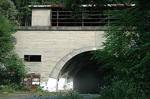
Sideling Hill Tunnel (Pennsylvania)
Sideling Hill Tunnel
Sideling Hill Tunnel is one of three original Pennsylvania Turnpike tunnels abandoned after two massive realignment projects. The others are nearby Rays Hill Tunnel, and further west, the Laurel Hill Tunnel. It was less expensive to realign the Turnpike than to bore a second tube for four lane...
, through Sideling Hill in Pennsylvania
Pennsylvania
The Commonwealth of Pennsylvania is a U.S. state that is located in the Northeastern and Mid-Atlantic regions of the United States. The state borders Delaware and Maryland to the south, West Virginia to the southwest, Ohio to the west, New York and Ontario, Canada, to the north, and New Jersey to...
east of Breezewood
Breezewood, Pennsylvania
Breezewood is an unincorporated town in Bedford County in south-central Pennsylvania.Along a traditional pathway for Native Americans, European settlers, and British troops during colonial times, in the early 20th century, the small valley that became known as Breezewood was a popular stopping...
, is currently in its third phase of life. In the 1880s, a tunnel was partially bored through the mountain by the South Pennsylvania Railroad
South Pennsylvania Railroad
The South Pennsylvania Railroad is the name given to two proposed but never completed Pennsylvania railroads in the nineteenth-century. Parts of the right of way for the second South Pennsylvania Railroad were reused for the Pennsylvania Turnpike....
. The railroad project ceased, and the tunnel was left abandoned. When construction of the Pennsylvania Turnpike
Pennsylvania Turnpike
The Pennsylvania Turnpike is a toll highway system operated by the Pennsylvania Turnpike Commission in the Commonwealth of Pennsylvania, United States. The three sections of the turnpike system total . The main section extends from Ohio to New Jersey and is long...
was begun in the 1930s by the Pennsylvania Turnpike Commission
Pennsylvania Turnpike Commission
The Pennsylvania Turnpike Commission was created in 1937 to construct, finance, operate and maintain the Pennsylvania Turnpike. The commission consists of five members. Four members are appointed by the Governor of Pennsylvania. The fifth member is the Pennsylvania Secretary of Transportation.In...
on the right-of-way
Right-of-way (railroad)
A right-of-way is a strip of land that is granted, through an easement or other mechanism, for transportation purposes, such as for a trail, driveway, rail line or highway. A right-of-way is reserved for the purposes of maintenance or expansion of existing services with the right-of-way...
of the old South Pennsylvania Railroad, the tunnel was completed for highway use by the Turnpike.
The tunnel, at 6782 feet (2,067.2 m) long the longest of the seven original Turnpike tunnels, was used from the Turnpike's opening in 1940 until 1968. Due to increasing traffic on the highway, the turnpike commission began upgrading all of its two-lane tunnels, constructing twin bores for its tunnels through the Allegheny, Tuscarora, Kittatinny, and Blue mountains, and bypassing the tunnels under Laurel Hill, Rays Hill, and Sideling Hill with new, four-lane highways climbing the adjacent hills. The Sideling Hill tunnel and the nearby Rays Hill tunnel
Abandoned Pennsylvania Turnpike
The Abandoned Pennsylvania Turnpike is the common name of a 13 mile stretch of the Pennsylvania Turnpike that was bypassed in 1968 when a modern stretch opened to ease traffic congestion in the tunnels. In this case, the Sideling Hill Tunnel and Rays Hill Tunnel were bypassed, as was one of the...
, along with connecting segments of four-lane highway, were used for many years as a testing facility for new highway technologies.
In 2001, the Sideling Hill Tunnel was sold to the Southern Alleghenies Conservancy
Southern Alleghenies Conservancy
Southern Alleghenies Conservancy is a non-profit nature group preserving the environment in South Western and South Central Pennsylvania, covering Bedford, Blair, Cambria, Fulton, Huntingdon, and Somerset counties.-Current projects:...
for $1, which now operates it as a bike trail.
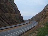
Sideling Hill Road Cut (I-68 and U.S. 40, Maryland)
Cut (earthmoving)
In civil engineering, a cut or cutting is where soil or rock material from a hill or mountain is cut out to make way for a canal, road or railway line....
on Interstate 68
Interstate 68
Interstate 68 is a Interstate highway in the U.S. states of West Virginia and Maryland, connecting in Morgantown to in Hancock. is also Corridor E of the Appalachian Development Highway System. From 1965 until the freeway's construction was completed in 1991, it was designated as...
and U.S. 40
U.S. Route 40
U.S. Route 40 is an east–west United States highway. As with most routes whose numbers end in a zero, U.S. 40 once traversed the entire United States. It is one of the original 1920s U.S. Highways, and its first termini were San Francisco, California, and Atlantic City, New Jersey...
is a 340 feet (103.6 m) deep notch excavated from the ridge of Sideling Hill, about 7 miles (11 km) west of Hancock
Hancock, Maryland
Hancock is a town in Washington County, Maryland, United States. The population was 1,725 at the 2000 census. The Western Maryland community is notable for being located at the narrowest part of the state...
in Washington County, Maryland
Washington County, Maryland
Washington County is a county located in the western part of the U.S. state of Maryland, bordering southern Pennsylvania to the north, northern Virginia to the south, and the Eastern Panhandle of West Virginia to the south and west. As of the 2010 Census, its population is 147,430...
. It is notable as an impressive man-made mountain pass, visible from miles away, and is considered to be one of the best rock exposures in Maryland and the entire northeastern United States
United States
The United States of America is a federal constitutional republic comprising fifty states and a federal district...
. Almost 810 feet (246.9 m) of strata
Stratum
In geology and related fields, a stratum is a layer of sedimentary rock or soil with internally consistent characteristics that distinguish it from other layers...
in a tightly folded syncline
Syncline
In structural geology, a syncline is a fold, with younger layers closer to the center of the structure. A synclinorium is a large syncline with superimposed smaller folds. Synclines are typically a downward fold, termed a synformal syncline In structural geology, a syncline is a fold, with younger...
are exposed in this road cut. Although other exposures may surpass Sideling Hill in either thickness of exposed strata or in quality of geologic structure, few can equal its combination of both. The exposed rocks consist of the Devonian
Devonian
The Devonian is a geologic period and system of the Paleozoic Era spanning from the end of the Silurian Period, about 416.0 ± 2.8 Mya , to the beginning of the Carboniferous Period, about 359.2 ± 2.5 Mya...
-Mississippian Rockwell Formation
Rockwell Formation
The Rockwell Formation is a late Devonian and early Mississippian mapped bedrock unit in West Virginia, Maryland, and Pennsylvania, in the United States.-Description:...
, underlying the Mississippian Purslane Sandstone
Pocono Formation
The Mississippian Pocono Formation is a mapped bedrock unit in Pennsylvania, Maryland, and West Virginia, USA. It is also known as the Pocono Group in Maryland and West Virginia,...
.
Rest stop and former Exhibit Center
A highway rest stop, located near the eastern side of the Sideling Hill Road Cut on Interstate 68 west of Hancock, includes a pedestrian bridge crossing I-68, connecting the eastbound and westbound rest areas and offering views of the cut, in which stopping is prohibited.The rest stop formerly included the Sideling Hill Exhibit Center, a four-level geological museum and travel information center which opened in 1991. Due to state budget cuts, this facility was closed on Aug. 15, 2009, as part of a $280 million budget reduction package, saving the state about $110,000 annually. Before its closing, the center served about 95,000 visitors a year, at a cost of about $1.16 per visitor.
Exhibits in Hancock, Maryland
Many of the geological exhibits from the former Exhibit Center are now displayed at the Hancock Museum in nearby Hancock, MarylandHancock, Maryland
Hancock is a town in Washington County, Maryland, United States. The population was 1,725 at the 2000 census. The Western Maryland community is notable for being located at the narrowest part of the state...
.
National Road (Scenic U.S. 40)
Before construction of I-68, U.S. 40 (now Scenic U.S. 40)U.S. Route 40 Scenic
U.S. Route 40 Scenic is a scenic route of U.S. Route 40 in the U.S. state of Maryland. US 40 Scenic is the old alignment of US 40 over Town Hill in eastern Allegany County and Sideling Hill in far western Washington County. The highway was originally constructed as part of the National Road in...
, the National Road
National Road
The National Road or Cumberland Road was the first major improved highway in the United States to be built by the federal government. Construction began heading west in 1811 at Cumberland, Maryland, on the Potomac River. It crossed the Allegheny Mountains and southwestern Pennsylvania, reaching...
, crossed Sideling Hill with a steep grade on each side and a sharp hairpin turn
Hairpin turn
A hairpin turn , named for its resemblance to a hairpin/bobby pin, is a bend in a road with a very acute inner angle, making it necessary for an oncoming vehicle to turn almost 180° to continue on the road. Such turns in ramps and trails may be called switchbacks in American English, by analogy...
at the crest of the mountain.
Potomac River Water Gap
The water gapWater gap
A water gap is an opening or notch which flowing water has carved through a mountain range. Water gaps often offer a practical route for road and rail transport to cross mountain ridges.- Geology :...
cut through Sideling Hill by the Potomac River
Potomac River
The Potomac River flows into the Chesapeake Bay, located along the mid-Atlantic coast of the United States. The river is approximately long, with a drainage area of about 14,700 square miles...
southwest (upstream) of Hancock, Maryland
Hancock, Maryland
Hancock is a town in Washington County, Maryland, United States. The population was 1,725 at the 2000 census. The Western Maryland community is notable for being located at the narrowest part of the state...
, provides a low-level crossing of the ridge for the CSX Railroad
CSX Transportation
CSX Transportation operates a Class I railroad in the United States known as the CSX Railroad. It is the main subsidiary of the CSX Corporation. The company is headquartered in Jacksonville, Florida, and owns approximately 21,000 route miles...
(formerly the main line of the Baltimore and Ohio (B&O) Railroad
Baltimore and Ohio Railroad
The Baltimore and Ohio Railroad was one of the oldest railroads in the United States and the first common carrier railroad. It came into being mostly because the city of Baltimore wanted to compete with the newly constructed Erie Canal and another canal being proposed by Pennsylvania, which...
, on the southern (West Virginia) side of the river, and on the northern (Maryland) side, the former Chesapeake and Ohio Canal
Chesapeake and Ohio Canal
The Chesapeake and Ohio Canal, abbreviated as the C&O Canal, and occasionally referred to as the "Grand Old Ditch," operated from 1831 until 1924 parallel to the Potomac River in Maryland from Cumberland, Maryland to Washington, D.C. The total length of the canal is about . The elevation change of...
, now a national historical park
Chesapeake and Ohio Canal National Historical Park
The Chesapeake and Ohio Canal National Historical Park is a United States National Historical Park located in the District of Columbia and the states of Maryland and West Virginia. The park was established as a National Monument in 1961 by President Dwight D...
, and the former Western Maryland Railroad (now a rail trail
Rail trail
A rail trail is the conversion of a disused railway easement into a multi-use path, typically for walking, cycling and sometimes horse riding. The characteristics of former tracks—flat, long, frequently running through historical areas—are appealing for various development. The term sometimes also...
).
See also
- Rays Hill TunnelRays Hill TunnelRays Hill Tunnel is one of three original Pennsylvania Turnpike tunnels which were abandoned after two massive realignment projects. The others included the Sideling Hill Tunnel, and further west, the Laurel Hill Tunnel. The reason for abandonment was because it was thought to be less expensive...
- Laurel Hill TunnelLaurel Hill TunnelLaurel Hill Tunnel is one of three original Pennsylvania Turnpike tunnels which were abandoned after two massive realignment projects.The Laurel Hill Tunnel was bored under the border between Westmoreland and Somerset Counties...
- Abandoned Pennsylvania TurnpikeAbandoned Pennsylvania TurnpikeThe Abandoned Pennsylvania Turnpike is the common name of a 13 mile stretch of the Pennsylvania Turnpike that was bypassed in 1968 when a modern stretch opened to ease traffic congestion in the tunnels. In this case, the Sideling Hill Tunnel and Rays Hill Tunnel were bypassed, as was one of the...
- Sideling Hill Creek