Sharing of Ganges Waters
Encyclopedia

Ganges River
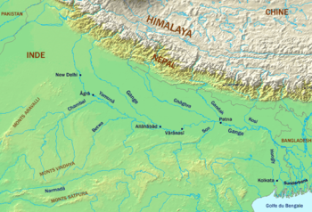
The Ganges or Ganga, , is a trans-boundary river of India and Bangladesh. The river rises in the western Himalayas in the Indian state of Uttarakhand, and flows south and east through the Gangetic Plain of North India into Bangladesh, where it empties into the Bay of Bengal. By discharge it...
' waters is a long-standing issue between India
India
India , officially the Republic of India , is a country in South Asia. It is the seventh-largest country by geographical area, the second-most populous country with over 1.2 billion people, and the most populous democracy in the world...
and Bangladesh
Bangladesh
Bangladesh , officially the People's Republic of Bangladesh is a sovereign state located in South Asia. It is bordered by India on all sides except for a small border with Burma to the far southeast and by the Bay of Bengal to the south...
over the appropriate allocation and development of the water resources of the Ganges River
Ganges River
The Ganges or Ganga, , is a trans-boundary river of India and Bangladesh. The river rises in the western Himalayas in the Indian state of Uttarakhand, and flows south and east through the Gangetic Plain of North India into Bangladesh, where it empties into the Bay of Bengal. By discharge it...
that flows from northern India into Bangladesh. The issue has remained a subject of conflict for almost 35 years, with several bilateral agreements and rounds of talks failing to produce results.
However, a comprehensive bilateral treaty was signed by the then-Indian Prime Minister H. D. Deve Gowda
H. D. Deve Gowda
Haradanahalli Doddegowda Deve Gowda was the 11th Prime Minister of India and the 14th chief minister of the state of Karnataka ....
and the then-Bangladeshi Prime Minister Sheikh Hasina Wajed on December 12, 1996 in the Indian capital of New Delhi
New Delhi
New Delhi is the capital city of India. It serves as the centre of the Government of India and the Government of the National Capital Territory of Delhi. New Delhi is situated within the metropolis of Delhi. It is one of the nine districts of Delhi Union Territory. The total area of the city is...
. The treaty established a 30-year water-sharing arrangement and recognized Bangladesh's rights as a lower-level riparian.
Background

Distributary
A distributary, or a distributary channel, is a stream that branches off and flows away from a main stream channel. They are a common feature of river deltas. The phenomenon is known as river bifurcation. The opposite of a distributary is a tributary...
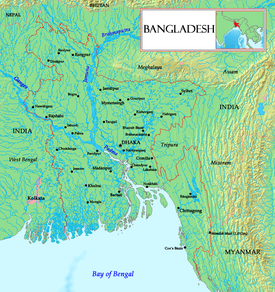
, the Bhagirathi River, which goes on to form the Hooghly River. About 10 kilometres from the border with Bangladesh the Farakka Barrage
Farakka Barrage
Farakka Barrage is a barrage across the Ganges River, located in the Indian state of West Bengal, roughly from the border with Bangladesh near Chapai Nawabganj District. Construction was started in 1961 and completed in 1975. Operations began on April 21, 1975. The barrage is about long...
, built in 1974, controls the flow of the Ganges, diverting some of the water into a feeder canal
Canal
Canals are man-made channels for water. There are two types of canal:#Waterways: navigable transportation canals used for carrying ships and boats shipping goods and conveying people, further subdivided into two kinds:...
linking the Hooghly to keep it relatively silt
Silt
Silt is granular material of a size somewhere between sand and clay whose mineral origin is quartz and feldspar. Silt may occur as a soil or as suspended sediment in a surface water body...
-free.
After entering Bangladesh, the main branch of the Ganges is known as the Padma River
Padma River
The Padma is a major trans-boundary river in Bangladesh. It is the main distributary of the Ganges , which originates in the Himalayas. The Padma enters Bangladesh from India near Chapai Nababganj...
until it is joined by the Jamuna River, the largest distributary of the Brahmaputra River
Brahmaputra River
The Brahmaputra , also called Tsangpo-Brahmaputra, is a trans-boundary river and one of the major rivers of Asia. It is the only Indian river that is attributed the masculine gender and thus referred to as a in Indo-Aryan languages and languages with Indo-Aryan influence...
, which descends from Assam
Assam
Assam , also, rarely, Assam Valley and formerly the Assam Province , is a northeastern state of India and is one of the most culturally and geographically distinct regions of the country...
and Northeast India. Further downstream, the Ganges is fed by the Meghna River
Meghna River
The Meghna River is an important river in Bangladesh, one of the three that forms the Ganges Delta, the largest on earth fanning out to the Bay of Bengal. Being a part of the Surma-Meghna River System, Meghna is formed inside Bangladesh by the joining of different rivers originaing from the hilly...
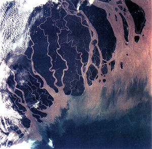
, the second-largest distributary of the Brahmaputra, and takes on the Meghna's name as it enters the Meghna estuary. Fanning out into the 350 km wide Ganges Delta
Ganges Delta
The Ganges Delta is a river delta in the South Asia region of Bengal, consisting of Bangladesh and the state of West Bengal, India. It is the world's largest delta, and empties into the Bay of Bengal...
, it finally empties into the Bay of Bengal
Bay of Bengal
The Bay of Bengal , the largest bay in the world, forms the northeastern part of the Indian Ocean. It resembles a triangle in shape, and is bordered mostly by the Eastern Coast of India, southern coast of Bangladesh and Sri Lanka to the west and Burma and the Andaman and Nicobar Islands to the...
. A total of 54 rivers flow into Bangladesh from India.
Efforts at resolution
The then-Indian Prime Minister Indira GandhiIndira Gandhi
Indira Priyadarshini Gandhara was an Indian politician who served as the third Prime Minister of India for three consecutive terms and a fourth term . She was assassinated by Sikh extremists...
and Bangladesh's founding leader Sheikh Mujibur Rahman
Sheikh Mujibur Rahman
Sheikh Mujibur Rahman was a Bengali nationalist politician and the founder of Bangladesh. He headed the Awami League, served as the first President of Bangladesh and later became its Prime Minister. He headed the Awami League, served as the first President of Bangladesh and later became its...
signed the wide-ranging Indo-Bangladeshi Treaty of Friendship, Cooperation and Peace on March 19, 1972; as per the treaty, the two nations established a Joint River Commission
Joint River Commission
The Joint River Commission was a bilateral working group established by India and Bangladesh in the Indo-Bangladeshi Treaty of Friendship, Cooperation and Peace that was signed on March 19, 1972 and came into being in November, 1972...
to work for the common interests and sharing of water resources, irrigation
Irrigation
Irrigation may be defined as the science of artificial application of water to the land or soil. It is used to assist in the growing of agricultural crops, maintenance of landscapes, and revegetation of disturbed soils in dry areas and during periods of inadequate rainfall...
, flood
Flood
A flood is an overflow of an expanse of water that submerges land. The EU Floods directive defines a flood as a temporary covering by water of land not normally covered by water...
s and cyclone
Cyclone
In meteorology, a cyclone is an area of closed, circular fluid motion rotating in the same direction as the Earth. This is usually characterized by inward spiraling winds that rotate anticlockwise in the Northern Hemisphere and clockwise in the Southern Hemisphere of the Earth. Most large-scale...
s control.
Farakka Barrage
The Farakka BarrageFarakka Barrage
Farakka Barrage is a barrage across the Ganges River, located in the Indian state of West Bengal, roughly from the border with Bangladesh near Chapai Nawabganj District. Construction was started in 1961 and completed in 1975. Operations began on April 21, 1975. The barrage is about long...
is a dam
Dam
A dam is a barrier that impounds water or underground streams. Dams generally serve the primary purpose of retaining water, while other structures such as floodgates or levees are used to manage or prevent water flow into specific land regions. Hydropower and pumped-storage hydroelectricity are...
on the Bhagirathi river located in the Indian state of West Bengal, roughly 10 km (6.2 mi) from the border with Bangladesh. India uses it to control the flow of the Ganges river. The dam was built to divert the Ganges River water into the Hooghly River during the dry season, from January to June, in order to flush out the accumulating silt
Silt
Silt is granular material of a size somewhere between sand and clay whose mineral origin is quartz and feldspar. Silt may occur as a soil or as suspended sediment in a surface water body...
which in the 1950s and 1960s was a problem at the Kolkata Port on the Hooghly River. Bangladesh claims that its rivers were drying up because of excess drawing of water by India. In May 1974 a joint declaration was issued to resolve the water–sharing issue before the Farakka Barrage was put into operation. This was followed by an interim agreement in 1975 to allow India to operate feeder canals
Canal
Canals are man-made channels for water. There are two types of canal:#Waterways: navigable transportation canals used for carrying ships and boats shipping goods and conveying people, further subdivided into two kinds:...
of the barrage for short periods.
However, India withdrew from the process of negotiations by September 1976 as both nations grew apart after the killing of Sheikh Mujib
Assassination of Sheikh Mujibur Rahman
The assassination of Sheikh Mujibur Rahman took place in the early hours of August 15, 1975, when a group of junior Bangladesh Army officers invaded Sheikh Mujibur Rahman's residence with tanks...
and establishment of military rule
Military coups in Bangladesh
Bangladesh has faced several military coups since its independence from Pakistan in 1971.-15 August:The coup of 15 August 1975 was organized by officers of Bangladesh Army. They were led by Major Syed Faruqe Rahman and Major Rashid...
. Bangladesh protested India's unilateral action at a summit of the Non-Aligned Movement
Non-Aligned Movement
The Non-Aligned Movement is a group of states considering themselves not aligned formally with or against any major power bloc. As of 2011, the movement had 120 members and 17 observer countries...
(NAM) and at the 31st session of the U.N. General Assembly. At the urging of other nations and the U.N., both India and Bangladesh agreed to resume dialogue, but with no results.
Temporary agreements
Bilateral relations had improved in 1977 during the governments of the then-Prime Minister Morarji DesaiMorarji Desai
Morarji Ranchhodji Desai was an Indian independence activist and the fourth Prime Minister of India from 1977–79. He was the first Indian Prime Minister who did not belong to the Indian National Congress...
of India and the then-President Ziaur Rahman
Ziaur Rahman
President Ziaur Rahman, Bir Uttam, was a Bangladeshi politician and general, who read the declaration of Independence of Bangladesh on March 26, 1971 on behalf of Sheikh Mujibur Rahman. He later became the seventh President of Bangladesh from 1977 until 1981...
of Bangladesh; in 1977 both leaders signed a 5-year treaty on water-sharing, but this duly expired in 1982 without being renewed.
On October 4, 1982 the then-Bangladeshi president Hossain Mohammad Ershad
Hossain Mohammad Ershad
Lieutenant General Hussain Muhammad Ershad is a Bangladeshi politician who was President of Bangladesh from 1983 to 1990. Previously, he was Chief of Staff of the Bangladesh Army and then Chief Martial Law Administrator in 1982....
signed with India a memorandum of understanding
Memorandum of understanding
A memorandum of understanding is a document describing a bilateral or multilateral agreement between parties. It expresses a convergence of will between the parties, indicating an intended common line of action. It is often used in cases where parties either do not imply a legal commitment or in...
(MoU) on water sharing for 2 years. On November 22, 1985 another MoU for 3 years was signed. As still there was no agreement on augmenting the flow, India did not agree to a further extension of the accord and reduced the river's dry season flow for Bangladesh in 1993 to lower than 10000 cuft/s in place of around 34500 cuft/s in the last accord. Bangladesh attempted to internationalise the affair by lobbying the U.N. General Assembly and the South Asian Association for Regional Cooperation
South Asian Association for Regional Cooperation
The South Asian Association for Regional Cooperation is an organisation of South Asian nations, founded in December 1985 by Ziaur Rahman and dedicated to economic, technological, social, and cultural development emphasising collective self-reliance. Its seven founding members are Bangladesh,...
(SAARC) without result.
1996 Treaty

The two countries also agreed to the need for mutual cooperation in augmenting the flow of the Ganges on a long-term basis, and for entering into similar accords in sharing the flows and developing the water resources of other shared rivers. It established India's pre-condition for augmenting the flow of the Ganges and recognised Bangladesh's right as a lower riparian to an equitable share of its existing flow. Both nations were able to cooperate in harnessing the water resources; the treaty also permits the construction of barrage
Barrage
Barrage may refer to:In music* Barrage , a Canadian violin ensemble, or* Barrage , their self-titled debut albumIn engineering...
s and irrigation projects in Kushtia and the Gorai-Madhumati River
Gorai-Madhumati River
The Gorai-Madhumati River is one of the longest rivers in Bangladesh and a distributary of the Ganges....
in Bangladesh, draining the southwestern districts and thus preserving the environment, natural and economic resources including the world's largest mangrove
Mangrove
Mangroves are various kinds of trees up to medium height and shrubs that grow in saline coastal sediment habitats in the tropics and subtropics – mainly between latitudes N and S...
forests in Sundarbans
Sundarbans
The Sundarbans [Sundarban Tour Booking-9051115228] is the largest single block of tidal halophytic mangrove forest in the world.The name Sundarban can be literally translated as "beautiful jungle" or "beautiful forest" in the Bengali language...
by preventing salinity
Salinity
Salinity is the saltiness or dissolved salt content of a body of water. It is a general term used to describe the levels of different salts such as sodium chloride, magnesium and calcium sulfates, and bicarbonates...
from the Bay of Bengal.
Assessment
The 1996 treaty established a long-term solution and considerably easing strains in Indo-Bangladeshi relations. The 1996 treaty has been attacked by the Awami League's main rival, the Bangladesh Nationalist PartyBangladesh Nationalist Party
The Bangladesh Nationalist Party , commonly referred to as the BNP, is the mainstream center-right political party in Bangladesh. BNP ruled Bangladesh total 18 years since her independence, the longest than any other party in Bangladesh...
(BNP), which is regarded as hostile to India, but it did not renege from the treaty when it came to power in 2001. The BNP and other Bangladeshi political factions allege that India is drawing excessive water and the amount allocated to Bangladesh is unjust and insufficient. India in turn complains that the water allocated to Bangladesh leaves it with less water than necessary for the functioning of the Kolkata Port and the National Thermal Power Corporation
National Thermal Power Corporation
NTPC Limited is the largest Indian state-owned energy service provider based in New Delhi, India. It is listed in Forbes Global 2000 for 2010 ranked it 341st in the world...
in Farakka.
Other critics have also stressed environmental reasons for India to reconsider its drawing of water at Farraka. Alarming increases in deforestation
Deforestation
Deforestation is the removal of a forest or stand of trees where the land is thereafter converted to a nonforest use. Examples of deforestation include conversion of forestland to farms, ranches, or urban use....
and erosion
Erosion
Erosion is when materials are removed from the surface and changed into something else. It only works by hydraulic actions and transport of solids in the natural environment, and leads to the deposition of these materials elsewhere...
at the upper levels of the Ganges river increases the deposition of silt
Silt
Silt is granular material of a size somewhere between sand and clay whose mineral origin is quartz and feldspar. Silt may occur as a soil or as suspended sediment in a surface water body...
at the lower level, which is already measured at 2 million tonnes annually, along with increased salinity have also led to desertification
Desertification
Desertification is the degradation of land in drylands. Caused by a variety of factors, such as climate change and human activities, desertification is one of the most significant global environmental problems.-Definitions:...
. In Bangladesh, the diversion has raised salinity levels, contaminated fisheries, hindered navigation and posed a threat to water quality and public health. Such silt levels are believed to be adversely affecting the Hooghly river and the Kolkata Port.

