
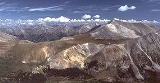
Mount Antero
Encyclopedia
Colorado
Colorado is a U.S. state that encompasses much of the Rocky Mountains as well as the northeastern portion of the Colorado Plateau and the western edge of the Great Plains...
, with an elevation of 14276 feet (4,351.3 m). Also known as Antero Peak, it is named for Chief Antero of the Uintah band of Ute
Ute Tribe
The Ute are an American Indian people now living primarily in Utah and Colorado. There are three Ute tribal reservations: Uintah-Ouray in northeastern Utah ; Southern Ute in Colorado ; and Ute Mountain which primarily lies in Colorado, but extends to Utah and New Mexico . The name of the state of...
s. It is located in the central Sawatch Range
Sawatch Range
The Sawatch Range is a mountain range in central Colorado which includes eight of the twenty highest peaks in the Rocky Mountains, including Mount Elbert, at elevation, the highest peak in the Rockies....
in Chaffee County
Chaffee County, Colorado
Chaffee County is one of the 64 counties of the state of Colorado of the United States. The county population was 16,242 at U.S. Census 2000. The county seat is Salida.-History:...
between the towns of Buena Vista
Buena Vista, Colorado
Buena Vista is a Statutory Town in Chaffee County, Colorado, United States. The population was 2,195 at the 2000 census.Buena Vista is located in central Colorado roughly midway between Salida and Leadville in the Upper Arkansas River Valley at an elevation of . The area between Buena Vista and...
and Salida
Salida, Colorado
The City of Salida is a Statutory City that is the county seat and most populous city of Chaffee County, Colorado, United States. The population was 5,504 at the U.S. Census 2000.-History:800px|thumb|left| Panoramic View of Salida, 1910...
. The mountain itself is prized for its gemstone deposits and has one of the highest concentrations of aquamarine in the country. There are several active private mining claims being exploited on Mt. Antero and surrounding peaks.
The peak is located entirely within the San Isabel National Forest
San Isabel National Forest
San Isabel National Forest is located in central Colorado. The forest contains 19 of the state's 54 fourteeners, peaks over high, including Mount Elbert, the highest point in Colorado....
, due south of the more visually prominent Mount Princeton
Mount Princeton
Mount Princeton is one of the fourteeners of the US state of Colorado. It lies in the Collegiate Peaks, in the central part of the Sawatch Range, just west of the Arkansas River. While not one of the highest peaks of the Sawatch, it is one of the most dramatic, as it rises over 6,500 feet from the...
. There are two popular climbing routes on Mount Antero. The generally accepted hiking route, which begins near the ghost town of St. Elmo
St. Elmo, Colorado
St. Elmo is a ghost town in Chaffee County, Colorado, United States. Founded in 1880, St. Elmo lies in the heart of the Sawatch Range, 20 miles southwest of Buena Vista. Nearly 2,000 people settled in this town when mining for gold and silver became evident. The mining industry started to decline...
, is from the east starting at the Browns Creek Trailhead and paralleling Little Browns Creek to its upper reaches where it crosses Forest Road 1A, then following the road near to the summit. The other route follows the same forest road from the north up Baldwin Creek. This route has heavy mining and tourist traffic in fair weather during the summer months.
The peak was surveyed by the Pike Expedition
Pike expedition
The Pike Expedition was a military effort authorized by the United States government to explore the south and west of the recent Louisiana Purchase. Roughly contemporaneous with the Lewis and Clark Expedition, it was led by United States Army Captain Zebulon Pike, Jr...
in 1806. A forest service sign at the Browns Creek trailhead commemorates the expedition camp at the eastern base of the peak.
See also
- List of Colorado fourteeners
- Mountain peaks of ColoradoMountain peaks of ColoradoThis article comprises three sortable tables of the major mountain peaks of the U.S. State of Colorado.Topographic elevation is the vertical distance above the reference geoid, a precise mathematical model of the Earth's sea level as an equipotential gravitational surface...
- Mountain ranges of ColoradoMountain ranges of ColoradoThe following table lists the major mountain ranges of the U.S. State of Colorado.-Mountain Ranges:-See also:*4000 meter peaks of Colorado*Colorado mountain passes*Geography of Colorado*Lists of mountains*Mountain peaks of Colorado...
Related Sources
San Isabel National Forest Map, United States Department of Agriculture, Forest Service (2003)External links
- Mount Antero at 14ers.com
- Mount Antero at Colorado Fourteeners Initiative
- Mount Antero at Distantpeak.com
- Mount Antero at ListsofJohn.com
- Mount Antero at Peakbagger.com
- Mount Antero at Peakery.com
- Mount Antero at USDA Forest Service