

Satellite geodesy
Encyclopedia
Satellite geodesy is the measurement of the form and dimensions of the Earth
, the location of objects on its surface and the figure of the Earth's gravity field by means of artificial satellite techniques—geodesy
by means of artificial satellites. It belongs to the broader field of space geodesy, which also includes such techniques as geodetic very long baseline interferometry
(VLBI) and lunar laser ranging. Traditional astronomical geodesy is not commonly considered a part of satellite geodesy, although there is considerable overlap between the techniques.
The main goals of satellite geodesy are:
Satellite geodetic data and methods can be applied to diverse fields such as navigation
, hydrography
, oceanography
and geophysics
. Satellite geodesy relies heavily on orbital mechanics.
in 1958 allowed for an accurate determination of Earth's flattening
. The 1960s saw the launch of the Doppler satellite Transit-1B
and the balloon satellites Echo 1, Echo 2, and PAGEOS
. The first dedicated geodetic satellite was ANNA-1B, a collaborative effort between NASA
, the DoD
, and other civilian agencies. ANNA-1B carried the first of the US Army's SECOR (Sequential Collation of Range) instruments. These missions led to the accurate determination of the leading spherical harmonic
coefficients of the geopotential, the general shape of the geoid
, and linked the world's geodetic datums.
 The Transit
satellite system was used extensively for Doppler surveying, navigation, and positioning. Observations of satellites in the 1970s by worldwide triangulation networks allowed for the establishment of the World Geodetic System
. The development of GPS by the United States in the 1980s allowed for precise navigation and positioning and soon became a standard tool in surveying. In the 1980s and 1990s satellite geodesy began to be used for monitoring of geodynamic phenomena, such as crustal motion
, Earth rotation
, and polar motion
.
 The 1990s were focused on the development of permanent geodetic networks and reference frames. Dedicated satellites were launched to measure Earth's gravity field in the 2000s, such as CHAMP
, GRACE
, and GOCE
.
 Techniques of satellite geodesy may be classified by instrument platform: A satellite may
. Each satellite transmits a precise ephemeris
with information on its own position and a message containing the exact time of transmission. The receiver compares this time of transmission with its own clock at the time of reception and multiplies the difference by the speed of light to obtain a "pseudorange
." In theory, three satellites are required to position the receiver in three-dimensional space, however the receiver's clock will likely not be synchronized with the atomic clocks aboard the satellite, so a fourth pseudorange measurement is used to correct the receiver's clock bias. In this manner, the receiver's position can be determined to within a few meters. More sophisticated methods, such as real-time kinematic
(RTK) can yield positions to within a few millimeters.
In geodesy, GNSS is used as an economical tool for surveying
and time transfer
. It is also used for monitoring Earth's rotation, polar motion
, and crustal
dynamics. The presence of the GPS signal in space also makes it suitable for orbit determination
and satellite-to-satellite tracking.
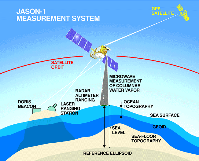
to satellites equipped with retroreflectors. This provides instantaneous range measurements of millimeter level precision which can be accumulated to provide accurate measurement of orbits and a host of important scientific data. Satellite laser ranging is a proven geodetic technique with significant potential for important contributions to scientific studies of the Earth/Atmosphere/Oceans system. It is the most accurate technique currently available to determine the geocentric position of an Earth satellite, allowing for the precise calibration of radar altimeters
and separation of long-term instrumentation drift from secular changes in ocean surface topography
.
positioning involves recording the Doppler shift of a radio signal of stable frequency emitted from a satellite as the satellite approaches and recedes from the observer. The observed frequency depends on the radial velocity of the satellite relative to the observer, which is constrained by orbital mechanics. If the observer knows the orbit of the satellite, then the recording the Doppler profile determines the observer's position. Conversely, if the observer's position is precisely known, then the orbit of the satellite can be determined and used to study the Earth's gravity. In DORIS
, the ground station emits the signal and the satellite receives.
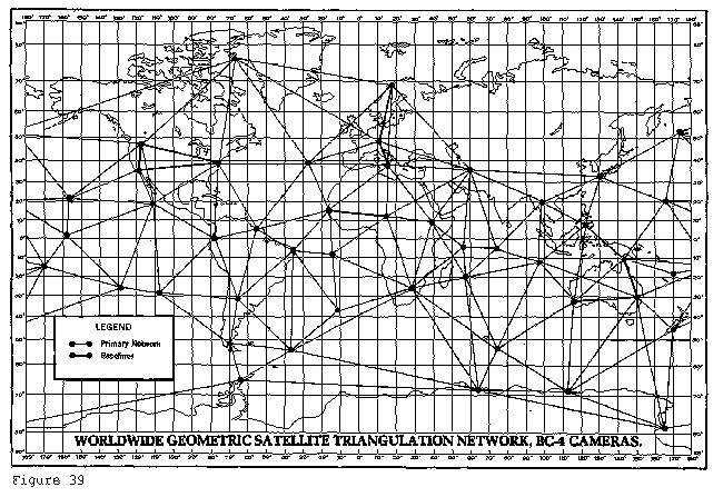
and can be used to ascertain the geometric relationship between multiple observing stations. Optical tracking with the BC-4, PC-1000, MOTS, or Baker Nunn cameras consisted of photographic observations of a satellite, or flashing light on the satellite, against a background of stars. The stars, whose positions were accurately determined, provided a framework on the photographic plate or film for a determination of precise directions from camera station to satellite. Geodetic positioning work with cameras was usually performed with one camera observing simultaneously with one or more other cameras. Camera systems are weather dependent and that is one major reason why they fell out of use by the 1980s.
uses the round-trip flight-time of a microwave pulse between the satellite and the Earth's surface to determine the distance between the spacecraft and the surface. From this distance or height, the local surface effects such as tides, winds and currents are removed to obtain the satellite height above the geoid. With a precise ephemeris available for the satellite, the geocentric distance to the satellite, determined for the time of each observation, along with the local radius of the ellipsoid are available. It is then possible to compute the geoid height by subtracting the ellipsoidal radius and the satellite height from the satellite's geocentric distance. This allows direct measurement of the geoid, since the ocean surface closely follows the geoid. The difference between the ocean surface and the actual geoid gives ocean surface topography
.
technique used in geodesy
and remote sensing
. This geodetic method uses two or more synthetic aperture radar
(SAR) images to generate maps of surface deformation or digital elevation, using differences in the phase of the waves returning to the satellite. The technique can potentially measure centimetre-scale changes in deformation over timespans of days to
years. It has applications for geophysical monitoring of natural hazards, for example earthquakes, volcanoes and landslides, and also in structural engineering, in particular monitoring of subsidence and structural stability.
, since it is the derivative of each component of the gravity vector taken in each sensitive axis. Thus, the value of any component of the gravity vector can be known all along the path of the vehicle if gravity gradiometers are included in the system and their outputs are integrated by the system computer. An accurate gravity model will be computed in real-time and a continuous map of normal gravity, elevation, and anomalous gravity will be available.
improvement. A high altitude satellite
may act as a relay from ground tracking stations to a low altitude satellite
. In this way, low altitude satellites may be observed when they are not accessible to ground stations. In this type of tracking, a signal generated by a tracking station is received by the relay satellite and then retransmitted to a lower altitude satellite. This signal is then returned to the ground station by the same path. Two low altitude satellites can track one another obsering mutual orbital variations caused by gravity field irregularities. A prime example of this is GRACE
. Several high altitude satellites with accurately known orbits, such as GPS satellites, may be used to fix the position of a low altitude satellite. These examples present a few of the possibilities for the application of satellite-to-satellite tracking. Satellite-to-satellite tracking data was first collected and analyzed in a high-low configuration between ATS-6
and GEOS-3. The data was studied to evaluate its potential for both orbit and gravitational model refinement.
Earth
Earth is the third planet from the Sun, and the densest and fifth-largest of the eight planets in the Solar System. It is also the largest of the Solar System's four terrestrial planets...
, the location of objects on its surface and the figure of the Earth's gravity field by means of artificial satellite techniques—geodesy
Geodesy
Geodesy , also named geodetics, a branch of earth sciences, is the scientific discipline that deals with the measurement and representation of the Earth, including its gravitational field, in a three-dimensional time-varying space. Geodesists also study geodynamical phenomena such as crustal...
by means of artificial satellites. It belongs to the broader field of space geodesy, which also includes such techniques as geodetic very long baseline interferometry
Very Long Baseline Interferometry
Very Long Baseline Interferometry is a type of astronomical interferometry used in radio astronomy. It allows observations of an object that are made simultaneously by many telescopes to be combined, emulating a telescope with a size equal to the maximum separation between the telescopes.Data...
(VLBI) and lunar laser ranging. Traditional astronomical geodesy is not commonly considered a part of satellite geodesy, although there is considerable overlap between the techniques.
The main goals of satellite geodesy are:
- Determination of the figure of the Earth, positioning, and navigation (geometric satellite geodesy)
- Determination of Earth's gravityEarth's gravityThe gravity of Earth, denoted g, refers to the acceleration that the Earth imparts to objects on or near its surface. In SI units this acceleration is measured in metres per second per second or equivalently in newtons per kilogram...
field and geoidGeoidThe geoid is that equipotential surface which would coincide exactly with the mean ocean surface of the Earth, if the oceans were in equilibrium, at rest , and extended through the continents . According to C.F...
(dynamical satellite geodesy) - Measurement of geodynamical phenomenaGeodynamicsGeodynamics is a subfield of geophysics dealing with dynamics of the Earth. It applies physics, chemistry and mathematics to the understanding of how mantle convection leads to plate tectonics and geologic phenomena such as seafloor spreading, mountain building, volcanoes, earthquakes, faulting and...
, such as crustal dynamicsCrust (geology)In geology, the crust is the outermost solid shell of a rocky planet or natural satellite, which is chemically distinct from the underlying mantle...
and polar motionPolar motionPolar motion of the earth is the movement of Earth's rotational axis across its surface. This is measured with respect to a reference frame in which the solid Earth is fixed...
Satellite geodetic data and methods can be applied to diverse fields such as navigation
Navigation
Navigation is the process of monitoring and controlling the movement of a craft or vehicle from one place to another. It is also the term of art used for the specialized knowledge used by navigators to perform navigation tasks...
, hydrography
Hydrography
Hydrography is the measurement of the depths, the tides and currents of a body of water and establishment of the sea, river or lake bed topography and morphology. Normally and historically for the purpose of charting a body of water for the safe navigation of shipping...
, oceanography
Oceanography
Oceanography , also called oceanology or marine science, is the branch of Earth science that studies the ocean...
and geophysics
Geophysics
Geophysics is the physics of the Earth and its environment in space; also the study of the Earth using quantitative physical methods. The term geophysics sometimes refers only to the geological applications: Earth's shape; its gravitational and magnetic fields; its internal structure and...
. Satellite geodesy relies heavily on orbital mechanics.
First steps (1957-1970)
Satellite geodesy began shortly after the launch of Sputnik in 1957. Observations of Explorer 1 and Sputnik 2Sputnik 2
Sputnik 2 , or Prosteyshiy Sputnik 2 ), was the second spacecraft launched into Earth orbit, on November 3, 1957, and the first to carry a living animal, a dog named Laika. Sputnik 2 was a 4-meter high cone-shaped capsule with a base diameter of 2 meters...
in 1958 allowed for an accurate determination of Earth's flattening
Figure of the Earth
The expression figure of the Earth has various meanings in geodesy according to the way it is used and the precision with which the Earth's size and shape is to be defined. The actual topographic surface is most apparent with its variety of land forms and water areas. This is, in fact, the surface...
. The 1960s saw the launch of the Doppler satellite Transit-1B
Transit (satellite)
The TRANSIT system, also known as NAVSAT , was the first satellite navigation system to be used operationally. The system was primarily used by the U.S...
and the balloon satellites Echo 1, Echo 2, and PAGEOS
PAGEOS
PAGEOS was a balloon satellite which was launched by the NASA in June 1966. Pageos had a diameter of exactly , consisted of a thick mylar plastic film coated with vapour deposited aluminium enclosing a volume of and was used for the Weltnetz der Satellitentriangulation -- a global cooperation...
. The first dedicated geodetic satellite was ANNA-1B, a collaborative effort between NASA
NASA
The National Aeronautics and Space Administration is the agency of the United States government that is responsible for the nation's civilian space program and for aeronautics and aerospace research...
, the DoD
United States Department of Defense
The United States Department of Defense is the U.S...
, and other civilian agencies. ANNA-1B carried the first of the US Army's SECOR (Sequential Collation of Range) instruments. These missions led to the accurate determination of the leading spherical harmonic
Spherical Harmonic
Spherical Harmonic is a science fiction novel from the Saga of the Skolian Empire by Catherine Asaro. It tells the story of Dyhianna Selei , the Ruby Pharaoh of the Skolian Imperialate, as she strives to reform her government and reunite her family in the aftermath of a devastating interstellar...
coefficients of the geopotential, the general shape of the geoid
Geoid
The geoid is that equipotential surface which would coincide exactly with the mean ocean surface of the Earth, if the oceans were in equilibrium, at rest , and extended through the continents . According to C.F...
, and linked the world's geodetic datums.
Toward the World Geodetic System (1970-1990)
Transit (satellite)
The TRANSIT system, also known as NAVSAT , was the first satellite navigation system to be used operationally. The system was primarily used by the U.S...
satellite system was used extensively for Doppler surveying, navigation, and positioning. Observations of satellites in the 1970s by worldwide triangulation networks allowed for the establishment of the World Geodetic System
World Geodetic System
The World Geodetic System is a standard for use in cartography, geodesy, and navigation. It comprises a standard coordinate frame for the Earth, a standard spheroidal reference surface for raw altitude data, and a gravitational equipotential surface that defines the nominal sea level.The latest...
. The development of GPS by the United States in the 1980s allowed for precise navigation and positioning and soon became a standard tool in surveying. In the 1980s and 1990s satellite geodesy began to be used for monitoring of geodynamic phenomena, such as crustal motion
Plate tectonics
Plate tectonics is a scientific theory that describes the large scale motions of Earth's lithosphere...
, Earth rotation
Earth rotation
Earth's rotation is the rotation of the solid Earth around its own axis. The Earth rotates towards the east. As viewed from the North Star Polaris, the Earth turns counter-clockwise.- Rotation period :...
, and polar motion
Polar motion
Polar motion of the earth is the movement of Earth's rotational axis across its surface. This is measured with respect to a reference frame in which the solid Earth is fixed...
.
Modern Era (1990-present)
CHAMP
CHAllenging Minisatellite Payload is a German satellite launched July 15, 2000 from Plesetsk, Russia and was used for atmospheric and ionospheric research, as well as other geoscientific applications, such as GPS radio occultation....
, GRACE
Gravity Recovery and Climate Experiment
The Gravity Recovery And Climate Experiment , a joint mission of NASA and the German Space Agency, has been making detailed measurements of Earth's gravity field since its launch in March 2002....
, and GOCE
Goce
Goce is an opera composed by Kiril Makedonski in tribute to Gotse Delchev. The work was commissioned to be the very first opera performed by the Macedonian National Opera Company. It premiered on May 24, 1954 and it is the first opera to be written in the Macedonian language....
.
Satellite geodetic measurement techniques
- be observed with ground-based instruments (Earth-to-space-methods),
- carry an instrument or sensor as part of its payload to observe the Earth (space-to-Earth methods),
- or use its instruments to track or be tracked by another satellite (space-to-space methods).
Geodetic use of GPS/GNSS
Global navigation satellite systems are dedicated radio positioning services, which can locate a receiver to within a few meters. The most prominent system, GPS, consists of a constellation of 31 satellites (as of June 2011) in high, 12-hour circular orbits, distributed in six planes with 55° inclinations. The principle of location is based on trilaterationTrilateration
In geometry, trilateration is the process of determinating absolute or relative locations of points by measurement of distances, using the geometry of circles, spheres or triangles. In addition to its interest as a geometric problem, trilateration does have practical applications in surveying and...
. Each satellite transmits a precise ephemeris
Ephemeris
An ephemeris is a table of values that gives the positions of astronomical objects in the sky at a given time or times. Different kinds of ephemerides are used for astronomy and astrology...
with information on its own position and a message containing the exact time of transmission. The receiver compares this time of transmission with its own clock at the time of reception and multiplies the difference by the speed of light to obtain a "pseudorange
Pseudorange
The pseudorange is the pseudo distance between a satellite and a navigation satellite receiver —for instance Global Positioning System receivers....
." In theory, three satellites are required to position the receiver in three-dimensional space, however the receiver's clock will likely not be synchronized with the atomic clocks aboard the satellite, so a fourth pseudorange measurement is used to correct the receiver's clock bias. In this manner, the receiver's position can be determined to within a few meters. More sophisticated methods, such as real-time kinematic
Real Time Kinematic
Real Time Kinematic satellite navigation is a technique used in land survey and in hydrographic survey based on the use of carrier phase measurements of the GPS, GLONASS and/or Galileo signals where a single reference station provides the real-time corrections, providing up to centimetre-level...
(RTK) can yield positions to within a few millimeters.
In geodesy, GNSS is used as an economical tool for surveying
Surveying
See Also: Public Land Survey SystemSurveying or land surveying is the technique, profession, and science of accurately determining the terrestrial or three-dimensional position of points and the distances and angles between them...
and time transfer
Time transfer
Time transfer is a scheme where multiple sites share a precise reference time. Time transfer solves problems such as astronomical observatories correlating observed flashes or other phenomenon with each other, as well as cell phone towers coordinating handoffs as a phone moves from one cell to...
. It is also used for monitoring Earth's rotation, polar motion
Polar motion
Polar motion of the earth is the movement of Earth's rotational axis across its surface. This is measured with respect to a reference frame in which the solid Earth is fixed...
, and crustal
Crust (geology)
In geology, the crust is the outermost solid shell of a rocky planet or natural satellite, which is chemically distinct from the underlying mantle...
dynamics. The presence of the GPS signal in space also makes it suitable for orbit determination
Orbit determination
Orbit determination is a branch of astronomy specialised in calculating, and hence predicting, the orbits of objects such as moons, planets, and spacecraft . These orbits could be orbiting the Earth, or other bodies...
and satellite-to-satellite tracking.
- Examples: GPS, GLONASSGLONASSGLONASS , acronym for Globalnaya navigatsionnaya sputnikovaya sistema or Global Navigation Satellite System, is a radio-based satellite navigation system operated for the Russian government by the Russian Space Forces...
, GalileoGalileo positioning systemGalileo is a global navigation satellite system currently being built by the European Union and European Space Agency . The €20 billion project is named after the famous Italian astronomer Galileo Galilei...
Laser ranging
In satellite laser ranging (SLR) a global network of observation stations measure the round trip time of flight of ultrashort pulses of lightLight
Light or visible light is electromagnetic radiation that is visible to the human eye, and is responsible for the sense of sight. Visible light has wavelength in a range from about 380 nanometres to about 740 nm, with a frequency range of about 405 THz to 790 THz...
to satellites equipped with retroreflectors. This provides instantaneous range measurements of millimeter level precision which can be accumulated to provide accurate measurement of orbits and a host of important scientific data. Satellite laser ranging is a proven geodetic technique with significant potential for important contributions to scientific studies of the Earth/Atmosphere/Oceans system. It is the most accurate technique currently available to determine the geocentric position of an Earth satellite, allowing for the precise calibration of radar altimeters
Altimeter
An altimeter is an instrument used to measure the altitude of an object above a fixed level. The measurement of altitude is called altimetry, which is related to the term bathymetry, the measurement of depth underwater.-Pressure altimeter:...
and separation of long-term instrumentation drift from secular changes in ocean surface topography
Ocean surface topography
The ocean surface has highs and lows, similar to the hills and valleys of Earth's land surface depicted on a topographic map. These variations, called "ocean surface topography" or "dynamic sea surface topography" are mapped using measurements of sea surface height relative to Earth's geoid...
.
- Example: LAGEOSLAGEOSLAGEOS, or Laser Geodynamics Satellites, are a series of scientific research satellites designed to provide an orbiting laser ranging benchmark for geodynamical studies of the Earth...
Doppler techniques
DopplerDoppler effect
The Doppler effect , named after Austrian physicist Christian Doppler who proposed it in 1842 in Prague, is the change in frequency of a wave for an observer moving relative to the source of the wave. It is commonly heard when a vehicle sounding a siren or horn approaches, passes, and recedes from...
positioning involves recording the Doppler shift of a radio signal of stable frequency emitted from a satellite as the satellite approaches and recedes from the observer. The observed frequency depends on the radial velocity of the satellite relative to the observer, which is constrained by orbital mechanics. If the observer knows the orbit of the satellite, then the recording the Doppler profile determines the observer's position. Conversely, if the observer's position is precisely known, then the orbit of the satellite can be determined and used to study the Earth's gravity. In DORIS
DORIS (geodesy)
Doppler Orbitography and Radiopositioning Integrated by Satellite is a French satellite system used for the determination of satellite orbits and for positioning.-Principle:...
, the ground station emits the signal and the satellite receives.
- Examples: TransitTransit (satellite)The TRANSIT system, also known as NAVSAT , was the first satellite navigation system to be used operationally. The system was primarily used by the U.S...
, DORISDORIS (geodesy)Doppler Orbitography and Radiopositioning Integrated by Satellite is a French satellite system used for the determination of satellite orbits and for positioning.-Principle:...
Optical tracking
In optical tracking, the satellite can be used as a very high target for triangulationStellar triangulation
Stellar triangulation is a method of geodesy which uses cosmic instead of terrestrial targets. It was first done by the Finnish geodesist Väisälä in 1959, who made astrometric photographs of the sky at two stations together with a balloon probe between them....
and can be used to ascertain the geometric relationship between multiple observing stations. Optical tracking with the BC-4, PC-1000, MOTS, or Baker Nunn cameras consisted of photographic observations of a satellite, or flashing light on the satellite, against a background of stars. The stars, whose positions were accurately determined, provided a framework on the photographic plate or film for a determination of precise directions from camera station to satellite. Geodetic positioning work with cameras was usually performed with one camera observing simultaneously with one or more other cameras. Camera systems are weather dependent and that is one major reason why they fell out of use by the 1980s.
- Examples: PAGEOSPAGEOSPAGEOS was a balloon satellite which was launched by the NASA in June 1966. Pageos had a diameter of exactly , consisted of a thick mylar plastic film coated with vapour deposited aluminium enclosing a volume of and was used for the Weltnetz der Satellitentriangulation -- a global cooperation...
, Project Echo
Radar altimetry
A radar altimeterRadar altimeter
A radar altimeter, radio altimeter, low range radio altimeter or simply RA measures altitude above the terrain presently beneath an aircraft or spacecraft...
uses the round-trip flight-time of a microwave pulse between the satellite and the Earth's surface to determine the distance between the spacecraft and the surface. From this distance or height, the local surface effects such as tides, winds and currents are removed to obtain the satellite height above the geoid. With a precise ephemeris available for the satellite, the geocentric distance to the satellite, determined for the time of each observation, along with the local radius of the ellipsoid are available. It is then possible to compute the geoid height by subtracting the ellipsoidal radius and the satellite height from the satellite's geocentric distance. This allows direct measurement of the geoid, since the ocean surface closely follows the geoid. The difference between the ocean surface and the actual geoid gives ocean surface topography
Ocean surface topography
The ocean surface has highs and lows, similar to the hills and valleys of Earth's land surface depicted on a topographic map. These variations, called "ocean surface topography" or "dynamic sea surface topography" are mapped using measurements of sea surface height relative to Earth's geoid...
.
- Examples: SeasatSeasatSEASAT was the first Earth-orbiting satellite designed for remote sensing of the Earth's oceans and had on board the first spaceborne synthetic aperture radar . The mission was designed to demonstrate the feasibility of global satellite monitoring of oceanographic phenomena and to help determine...
, GeosatGeosatThe GEOSAT was a U.S. Navy Earth observation satellite, launched on March 12, 1985 into an 800 km, 108° inclination orbit, with an orbital period of 23.07 days and a 330 pass orbit. The satellite carried a radar altimeter capable of measuring the distance from the satellite to sea surface...
, TOPEX/PoseidonTOPEX/PoseidonLaunched in 1992, TOPEX/Poseidon was a joint satellite mission between NASA, the U.S. space agency, and CNES, the French space agency, to map ocean surface topography. The first major oceanographic research vessel to sail into space, TOPEX/Poseidon helped revolutionize oceanography by proving the...
, ERS-1, ERS-2, Jason-1, Jason-2, EnvisatEnvisatEnvisat is an Earth-observing satellite. It was launched on 1 March 2002 aboard an Ariane 5 from the Guyana Space Centre in Kourou, French Guyana into a Sun synchronous polar orbit at an altitude of...
Laser altimetry
A laser altimeter uses the round-trip flight-time of a beam of light at optical or infrared wavelengths to determine the spacecraft's altitude.- Example: ICESatICESatICESat , part of NASA's Earth Observing System, was a satellite mission for measuring ice sheet mass balance, cloud and aerosol heights, as well as land topography and vegetation characteristics...
Interferometric synthetic aperture radar (InSAR)
Interferometric synthetic aperture radar (InSAR) is a radarRadar
Radar is an object-detection system which uses radio waves to determine the range, altitude, direction, or speed of objects. It can be used to detect aircraft, ships, spacecraft, guided missiles, motor vehicles, weather formations, and terrain. The radar dish or antenna transmits pulses of radio...
technique used in geodesy
Geodesy
Geodesy , also named geodetics, a branch of earth sciences, is the scientific discipline that deals with the measurement and representation of the Earth, including its gravitational field, in a three-dimensional time-varying space. Geodesists also study geodynamical phenomena such as crustal...
and remote sensing
Remote sensing
Remote sensing is the acquisition of information about an object or phenomenon, without making physical contact with the object. In modern usage, the term generally refers to the use of aerial sensor technologies to detect and classify objects on Earth by means of propagated signals Remote sensing...
. This geodetic method uses two or more synthetic aperture radar
Synthetic aperture radar
Synthetic-aperture radar is a form of radar whose defining characteristic is its use of relative motion between an antenna and its target region to provide distinctive long-term coherent-signal variations that are exploited to obtain finer spatial resolution than is possible with conventional...
(SAR) images to generate maps of surface deformation or digital elevation, using differences in the phase of the waves returning to the satellite. The technique can potentially measure centimetre-scale changes in deformation over timespans of days to
years. It has applications for geophysical monitoring of natural hazards, for example earthquakes, volcanoes and landslides, and also in structural engineering, in particular monitoring of subsidence and structural stability.
- Example: SeasatSeasatSEASAT was the first Earth-orbiting satellite designed for remote sensing of the Earth's oceans and had on board the first spaceborne synthetic aperture radar . The mission was designed to demonstrate the feasibility of global satellite monitoring of oceanographic phenomena and to help determine...
, TerraSAR-XTerraSAR-XTerraSAR-X, a German Earth observation satellite, is a joint venture being carried out under a public-private-partnership between the German Aerospace Center DLR and EADS Astrium GmbH; the exclusive commercial exploitation rights are held by the geo-information service provider Infoterra GmbH....
Gravity gradiometry
A gravity gradiometer can independently determine the components of the gravity vector on a real-time basis. A gravity gradient is simply the spatial derivative of the gravity vector. The gradient can be thought of as the rate of change of a component of the gravity vector as measured over a small distance. Hence, the gradient can be measured by determining the difference in gravity at two close but distinct points. This principle is embodied in several recent moving-base instruments. The gravity gradient at a point is a tensorTensor
Tensors are geometric objects that describe linear relations between vectors, scalars, and other tensors. Elementary examples include the dot product, the cross product, and linear maps. Vectors and scalars themselves are also tensors. A tensor can be represented as a multi-dimensional array of...
, since it is the derivative of each component of the gravity vector taken in each sensitive axis. Thus, the value of any component of the gravity vector can be known all along the path of the vehicle if gravity gradiometers are included in the system and their outputs are integrated by the system computer. An accurate gravity model will be computed in real-time and a continuous map of normal gravity, elevation, and anomalous gravity will be available.
- Example: GOCEGoceGoce is an opera composed by Kiril Makedonski in tribute to Gotse Delchev. The work was commissioned to be the very first opera performed by the Macedonian National Opera Company. It premiered on May 24, 1954 and it is the first opera to be written in the Macedonian language....
Satellite-to-satellite tracking
This technique uses satellites to track other satellites. There are a number of variations which may be used for specific purposes such as gravity field investigations and orbitOrbit
In physics, an orbit is the gravitationally curved path of an object around a point in space, for example the orbit of a planet around the center of a star system, such as the Solar System...
improvement. A high altitude satellite
Medium Earth Orbit
Medium Earth orbit , sometimes called intermediate circular orbit , is the region of space around the Earth above low Earth orbit and below geostationary orbit ....
may act as a relay from ground tracking stations to a low altitude satellite
Low Earth orbit
A low Earth orbit is generally defined as an orbit within the locus extending from the Earth’s surface up to an altitude of 2,000 km...
. In this way, low altitude satellites may be observed when they are not accessible to ground stations. In this type of tracking, a signal generated by a tracking station is received by the relay satellite and then retransmitted to a lower altitude satellite. This signal is then returned to the ground station by the same path. Two low altitude satellites can track one another obsering mutual orbital variations caused by gravity field irregularities. A prime example of this is GRACE
Gravity Recovery and Climate Experiment
The Gravity Recovery And Climate Experiment , a joint mission of NASA and the German Space Agency, has been making detailed measurements of Earth's gravity field since its launch in March 2002....
. Several high altitude satellites with accurately known orbits, such as GPS satellites, may be used to fix the position of a low altitude satellite. These examples present a few of the possibilities for the application of satellite-to-satellite tracking. Satellite-to-satellite tracking data was first collected and analyzed in a high-low configuration between ATS-6
ATS-6
ATS-6 was a NASA experimental satellite, built by Fairchild Space and Electronics Division It has been called the world's first educational satellite as well as world's first experimental Direct Broadcast Satellite as part of the Satellite Instructional Television Experiment between NASA and ISRO...
and GEOS-3. The data was studied to evaluate its potential for both orbit and gravitational model refinement.
- Example: GRACEGravity Recovery and Climate ExperimentThe Gravity Recovery And Climate Experiment , a joint mission of NASA and the German Space Agency, has been making detailed measurements of Earth's gravity field since its launch in March 2002....
List of geodetic satellites
- ANNA-1B
- CHAMPCHAMPCHAllenging Minisatellite Payload is a German satellite launched July 15, 2000 from Plesetsk, Russia and was used for atmospheric and ionospheric research, as well as other geoscientific applications, such as GPS radio occultation....
- EchoEcho satelliteProject Echo was the first passive communications satellite experiment. Each of the two American spacecraft was a metalized balloon satellite acting as a passive reflector of microwave signals. Communication signals were bounced off of them from one point on Earth to another.-Echo 1:NASA's Echo 1...
- Experimental Geodetic PayloadExperimental Geodetic PayloadThe Experimental Geodetic Payload is a Japanese satellite sponsored by NASDA, and launched in 1986 on the first flight of the H-I rocket. After launch, the satellite was renamed Ajisai , but it is most commonly known by the acronym EGP...
- Explorer programExplorer programThe Explorer program is a United States space exploration program that provides flight opportunities for physics, heliophysics, and astrophysics investigations from space. Over 90 space missions have been launched from 1958 to 2011, and it is still active...
- GalileoGalileo positioning systemGalileo is a global navigation satellite system currently being built by the European Union and European Space Agency . The €20 billion project is named after the famous Italian astronomer Galileo Galilei...
- GLONASSGLONASSGLONASS , acronym for Globalnaya navigatsionnaya sputnikovaya sistema or Global Navigation Satellite System, is a radio-based satellite navigation system operated for the Russian government by the Russian Space Forces...
- GOCEGoceGoce is an opera composed by Kiril Makedonski in tribute to Gotse Delchev. The work was commissioned to be the very first opera performed by the Macedonian National Opera Company. It premiered on May 24, 1954 and it is the first opera to be written in the Macedonian language....
- GPS
- GRACEGravity Recovery and Climate ExperimentThe Gravity Recovery And Climate Experiment , a joint mission of NASA and the German Space Agency, has been making detailed measurements of Earth's gravity field since its launch in March 2002....
- LAGEOSLAGEOSLAGEOS, or Laser Geodynamics Satellites, are a series of scientific research satellites designed to provide an orbiting laser ranging benchmark for geodynamical studies of the Earth...
- PAGEOSPAGEOSPAGEOS was a balloon satellite which was launched by the NASA in June 1966. Pageos had a diameter of exactly , consisted of a thick mylar plastic film coated with vapour deposited aluminium enclosing a volume of and was used for the Weltnetz der Satellitentriangulation -- a global cooperation...
- Starlette and Stella
- TOPEX/PoseidonTOPEX/PoseidonLaunched in 1992, TOPEX/Poseidon was a joint satellite mission between NASA, the U.S. space agency, and CNES, the French space agency, to map ocean surface topography. The first major oceanographic research vessel to sail into space, TOPEX/Poseidon helped revolutionize oceanography by proving the...
- TRANSITTransit (satellite)The TRANSIT system, also known as NAVSAT , was the first satellite navigation system to be used operationally. The system was primarily used by the U.S...