

Sanborn Maps
Encyclopedia
Place in history
The Sanborn Maps were originally created for assessing fire insurance liability in urbanized areas in the United StatesUnited States
The United States of America is a federal constitutional republic comprising fifty states and a federal district...
. The maps include detailed information regarding town and building information in approximately 12,000 U.S. towns and cities from 1867 to 2007. Author Kim Keister describes the legacy of Sanborn maps: "Stated simply, the Sanborn maps survive as a guide to American urbanization
Urbanization
Urbanization, urbanisation or urban drift is the physical growth of urban areas as a result of global change. The United Nations projected that half of the world's population would live in urban areas at the end of 2008....
that is unrivaled by other cartography
Cartography
Cartography is the study and practice of making maps. Combining science, aesthetics, and technique, cartography builds on the premise that reality can be modeled in ways that communicate spatial information effectively.The fundamental problems of traditional cartography are to:*Set the map's...
and, for that matter, by few documentary resources of any kind." They are a highly useful resource for historical research, planning, preservation, genealogical research, sociological
Sociology
Sociology is the study of society. It is a social science—a term with which it is sometimes synonymous—which uses various methods of empirical investigation and critical analysis to develop a body of knowledge about human social activity...
studies and research of urban geography.
Mapping for insurance, and specifically fire insurance, purposes had existed for a century prior to the emergence of the Sanborn Company, first beginning in London
London
London is the capital city of :England and the :United Kingdom, the largest metropolitan area in the United Kingdom, and the largest urban zone in the European Union by most measures. Located on the River Thames, London has been a major settlement for two millennia, its history going back to its...
in the late 18th century. In the decades following the end of the Civil War
American Civil War
The American Civil War was a civil war fought in the United States of America. In response to the election of Abraham Lincoln as President of the United States, 11 southern slave states declared their secession from the United States and formed the Confederate States of America ; the other 25...
, fire insurance mapping grew rapidly, mirroring the flourish of growth in the country, the rebuilding of the South and massive westward expansion. Factors such as the Homestead Act
Homestead Act
A homestead act is one of three United States federal laws that gave an applicant freehold title to an area called a "homestead" – typically 160 acres of undeveloped federal land west of the Mississippi River....
, railroad construction, the Industrial Revolution
Industrial Revolution
The Industrial Revolution was a period from the 18th to the 19th century where major changes in agriculture, manufacturing, mining, transportation, and technology had a profound effect on the social, economic and cultural conditions of the times...
and massive immigration
Immigration
Immigration is the act of foreigners passing or coming into a country for the purpose of permanent residence...
into the United States all fostered huge population growths, urbanization, and heightened demand for mapping.
The Sanborn Company began making fire insurance maps in 1867 when founded by Daniel Alfred Sanborn
Daniel Alfred Sanborn
Daniel Alfred Sanborn was a surveyor who founded the Sanborn Map Company, a well-known provider of fire insurance maps....
, a surveyor from Somerville, Massachusetts
Somerville, Massachusetts
Somerville is a city in Middlesex County, Massachusetts, United States, located just north of Boston. As of the 2010 census, the city had a total population of 75,754 and was the most densely populated municipality in New England. It is also the 17th most densely populated incorporated place in...
. The Sanborn Map Company created maps for fire insurance assessment in the U.S. and within several decades became the largest and most successful American map company. Sanborn was headquartered in Pelham, New York
Pelham, New York
Pelham, New York is the name of two locations in Westchester County, New York:*Pelham , New York, the Town of Pelham*Pelham Manor , New York, the Village of Pelham Manor*Pelham , New York, the Village of Pelham...
, but had regional offices in San Francisco, Chicago
Chicago
Chicago is the largest city in the US state of Illinois. With nearly 2.7 million residents, it is the most populous city in the Midwestern United States and the third most populous in the US, after New York City and Los Angeles...
, and Atlanta. The Sanborn Company sent out legions of surveyors to record the building footprints and relevant details about these buildings in all major urbanized areas regarding their fire liability. It was because of these details and the accuracy of the Sanborn maps, coupled with the Sanborn Company’s standardized symbolization and aesthetic appeal that made the Sanborn Company so successful and their maps so widely utilized.
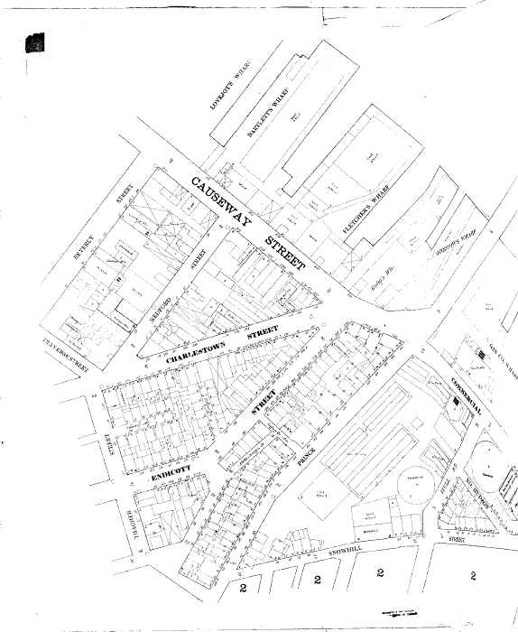
The volumes contain an enormous amount of information. They are organized as follows: a decorative title page, an index of streets and addresses, a ‘specials’ index with the names of churches, schools, businesses etc., and a master index indicating the entirety of the mapped area and the sheet numbers for each large-scale map (usually depicting four to six blocks) and general information such as population, economy and prevailing wind direction. The maps include outlines of each building and outbuilding, the location of windows and doors, street names, street and sidewalk widths, property boundaries, fire walls, natural features (river
River
A river is a natural watercourse, usually freshwater, flowing towards an ocean, a lake, a sea, or another river. In a few cases, a river simply flows into the ground or dries up completely before reaching another body of water. Small rivers may also be called by several other names, including...
s, canal
Canal
Canals are man-made channels for water. There are two types of canal:#Waterways: navigable transportation canals used for carrying ships and boats shipping goods and conveying people, further subdivided into two kinds:...
s, etc), railroad corridors, building use (sometimes even particular room uses), house and block number, as well as the composition of building materials including the framing, flooring, and roofing materials, the strength of the local fire department, indications of sprinkler systems, locations of fire hydrants, location of water and gas mains and even the names of most public buildings, churches and companies.
Fire department
A fire department or fire brigade is a public or private organization that provides fire protection for a certain jurisdiction, which typically is a municipality, county, or fire protection district...
s, the location of gas lines et cetera. The very decision as to how much, if any insurance was to be offered to a customer was often determined solely through the use of a Sanborn map. The maps also allowed insurance companies to visualize their entire coverage areas; when an agent sold a policy he could color in the corresponding building on the map and thus visualize the companies’ coverage of an area.
Today Sanborn maps are found primarily in the archives and special collection of town halls and public and university libraries, and remain a vital resource for people in many different fields. Historical research is the most obvious use, with the maps facilitating the study of urban growth and decline patterns, and for research into the evolution of specific buildings, sites and districts. Genealogists use the maps to locate the residences and workplaces of ancestors. Planners
Urban planning
Urban planning incorporates areas such as economics, design, ecology, sociology, geography, law, political science, and statistics to guide and ensure the orderly development of settlements and communities....
use the maps to study historic urban planning designs. Historic preservationists utilize the maps to understand the significance and historical evolution of buildings, including their historic uses and building materials in conservation and rehabilitation efforts. Demographers and urban geographers utilize the maps to study patterns of growth and migration of populations.
Historic Sanborn maps may be accessed in a variety of ways. Many are available through public or university libraries, or most comprehensively through the Library of Congress
Library of Congress
The Library of Congress is the research library of the United States Congress, de facto national library of the United States, and the oldest federal cultural institution in the United States. Located in three buildings in Washington, D.C., it is the largest library in the world by shelf space and...
. One may also obtain copyright
Copyright
Copyright is a legal concept, enacted by most governments, giving the creator of an original work exclusive rights to it, usually for a limited time...
information or request copies of the maps for purchase through the current owners, Environmental Data Resources, Incorporated.
Warren Buffett
Sanborn Map Company was an early holding of a young Warren BuffettWarren Buffett
Warren Edward Buffett is an American business magnate, investor, and philanthropist. He is widely regarded as one of the most successful investors in the world. Often introduced as "legendary investor, Warren Buffett", he is the primary shareholder, chairman and CEO of Berkshire Hathaway. He is...
in the early 1960s through his first investment partnership. Buffett advocated for change at the company, which had built a large investment portfolio over time. At one point, Sanborn Map represented 35% of total investment assets under Buffett's partnership.
External links
- Sanborn Map Company
- ProQuest Digital Sanborn Maps, 1867-1970 - pay site
- Environmental Data Resources Sanborn Maps, 1867 - 2007 - pay site
- Sanborn Maps from over 15 states - Library of Congress
- Sanborn Maps of North Carolina, 1884-1922 - University of North Carolina at Chapel Hill
- Sanborn Maps of Missouri, 1883-1951 - University of Missouri, Columbia
- Sanborn Maps of Florida, 1860-1923 - University of Florida Library
- Sanborn Maps of Utah, 1884-1922 - University of Utah Library
- Sanborn Maps of South Carolina, 1884-1960 - University of South Carolina Library
- Sanborn Maps of Alabama, 1884-1950 - University of Alabama
- Sanborn Maps of Hallowell, Maine, 1890 - David Rumsey
- Sanborn Maps of Frankfort, Kentucky, 1907 - David Rumsey
- Sanborn Maps of Indianapolis, Indiana, 1887-1941 - Indiana University
- Sanborn Maps of Georgia, 1884-1922 - Digital Library of Georgia
- Sanborn Maps of Toledo, Ohio, 1902 - Toledo's Attic
- Sanborn Maps of Cincinnati, Ohio - The Public Library of Cincinnati and Hamilton County
- Sanborn Maps of Muncie, Indiana, 1883-1911 - Ball State University Library
- Sanborn Maps of St. Louis, Missouri, 1870-1904 - Washington University, St. Louis
- Sanborn Maps of San Francisco, 1900 - SF Genealogy
- Sanborn Maps of Milwaukee, 1894 and 1910 - University of Wisconsin-Milwaukee Libraries Digital Collections
- Sanborn Maps of Colorado, 1883-1922 - University of Colorado Digital Library