

San Marcos (department)
Encyclopedia
San Marcos is a department
in Guatemala
. The capital is the city of San Marcos.
In 1902 the eruption of the Santa María volcano in the neighbouring department of Quetzaltenango was responsible for the destruction of the twin towns of San Marcos
and San Pedro Sacatepéquez
. The towns were rebuilt and in 1935 were joined to form the new municipality of San Marcos La Unión. This new municipality did not last long and the unified municipalities were again split in 1945 with San Marcos remaining the departmental capital.
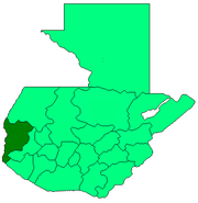 San Marcos is bordered on the north by the department of Huehuetenango, on the east by the department of Quetzaltenango, to the south by the department of Retalhuleu and by the Pacific Ocean
, and on the west by the Mexican
state of Chiapas
. The department has a total territory of 2397 square kilometres (925.5 sq mi).
The northern portion of the department is mountainous, being crossed by the Sierra Madre
mountain range, with the two highest volcanoes in Central America
being located within its borders. These are Tajumulco (4220 metres (13,845.1 ft) high) and Tacaná (4092 metres (13,425.2 ft) high). The Tajumulco volcano is the highest peak in Central America. Other notable peaks include San Antonio Ichiguán at 4022 metres (13,195.5 ft) above mean sea level
. The southern portion of the department drops away towards the Pacific coast.
The Tacaná volcano, which occupies the border with Mexico and has slopes in both countries, has been historically active, with activity recorded in 1855, 1878, from 1900 through to 1903, from 1949 to 1950 and from 1986 to 1987.
Principal rivers in the department include the Suchiate River
, which marks the border between San Marcos and Mexico and flows into the Pacific. The Cabuz River has its source on the slopes of the Tajumulco volcano. Other rivers include the El Pajapa, El Rodeo, Ixlamá, Ixtal, Meléndrez, Nahuatán, Ocosito
and Tilapa Rivers.
The climate varies widely within the department, due to the dramatic differences in altitude, with the north possessing a cold highland
climate and the south having a temperate or hot climate, depending on the specific altitude.
, Mam
and Sipakapense.
s, banana
s, barley
, beans
, cacao, coffee
, maize
, oat
s, peach
es, plantain
s, potato
es, rice
, sugarcane
and wheat
. Livestock include cattle
, horse
s and sheep. San Marcos department produces more wool
than any other department of Guatemala. It is generally exported to the departments of Quetzaltenango and Totonicapán, where it is processed into finished products. The department produces wooden furniture, with production being concentrated in the Pacific lowlands due to the greater variety of wood available, including cedar, ceiba
and tepemixte.
The department is notable for the importation of black market Mexican products, which are sold openly in local markets throughout its territory and from there are exported throughout Guatemala.
 The main tourist attractions of the San Marcos department are its various Pacific beaches. Other attractions include thermal baths and the caves of Castalia.
Departments of Guatemala
||Guatemala is divided into 22 departments :#Alta Verapaz#Baja Verapaz#Chimaltenango#Chiquimula#Petén#El Progreso#El Quiché#Escuintla#Guatemala#Huehuetenango#Izabal#Jalapa#Jutiapa#Quetzaltenango#Retalhuleu#Sacatepéquez...
in Guatemala
Guatemala
Guatemala is a country in Central America bordered by Mexico to the north and west, the Pacific Ocean to the southwest, Belize to the northeast, the Caribbean to the east, and Honduras and El Salvador to the southeast...
. The capital is the city of San Marcos.
Departmental history
The department was created by a governmental decree on 8 May 1866, together with Huehuetenango, Izabal and Petén departments. Before this it was known as the Barrio of San Marcos ("District of San Marcos"), which was a part of the department of Quetzaltenango.In 1902 the eruption of the Santa María volcano in the neighbouring department of Quetzaltenango was responsible for the destruction of the twin towns of San Marcos
San Marcos, Guatemala
San Marcos San Marcos San Marcos (elevation: 7,868 feet (2,398 meters) is a city and municipality in Guatemala.It is the capital of the department of San Marcos.The municipality has a population of approximately 45,000.-Sports:...
and San Pedro Sacatepéquez
San Pedro Sacatepéquez, San Marcos
San Pedro Sacatepéquez is a municipality in the San Marcos department of Guatemala with territory of 148 km2 at 2033 m altitude. The population is 63 688....
. The towns were rebuilt and in 1935 were joined to form the new municipality of San Marcos La Unión. This new municipality did not last long and the unified municipalities were again split in 1945 with San Marcos remaining the departmental capital.
Geography
Pacific Ocean
The Pacific Ocean is the largest of the Earth's oceanic divisions. It extends from the Arctic in the north to the Southern Ocean in the south, bounded by Asia and Australia in the west, and the Americas in the east.At 165.2 million square kilometres in area, this largest division of the World...
, and on the west by the Mexican
Mexico
The United Mexican States , commonly known as Mexico , is a federal constitutional republic in North America. It is bordered on the north by the United States; on the south and west by the Pacific Ocean; on the southeast by Guatemala, Belize, and the Caribbean Sea; and on the east by the Gulf of...
state of Chiapas
Chiapas
Chiapas officially Estado Libre y Soberano de Chiapas is one of the 31 states that, with the Federal District, comprise the 32 Federal Entities of Mexico. It is divided in 118 municipalities and its capital city is Tuxtla Gutierrez. Other important cites in Chiapas include San Cristóbal de las...
. The department has a total territory of 2397 square kilometres (925.5 sq mi).
The northern portion of the department is mountainous, being crossed by the Sierra Madre
Sierra Madre de Chiapas
Sierra Madre is a mountain range which runs northwest-southeast from the state of Chiapas in Mexico across Guatemala and into El Salvador and Honduras. Most of the volcanoes of Guatemala are a part of this range.A narrow coastal plain lies south the range, between the Sierra Madre and the Pacific...
mountain range, with the two highest volcanoes in Central America
Central America
Central America is the central geographic region of the Americas. It is the southernmost, isthmian portion of the North American continent, which connects with South America on the southeast. When considered part of the unified continental model, it is considered a subcontinent...
being located within its borders. These are Tajumulco (4220 metres (13,845.1 ft) high) and Tacaná (4092 metres (13,425.2 ft) high). The Tajumulco volcano is the highest peak in Central America. Other notable peaks include San Antonio Ichiguán at 4022 metres (13,195.5 ft) above mean sea level
Above mean sea level
The term above mean sea level refers to the elevation or altitude of any object, relative to the average sea level datum. AMSL is used extensively in radio by engineers to determine the coverage area a station will be able to reach...
. The southern portion of the department drops away towards the Pacific coast.
The Tacaná volcano, which occupies the border with Mexico and has slopes in both countries, has been historically active, with activity recorded in 1855, 1878, from 1900 through to 1903, from 1949 to 1950 and from 1986 to 1987.
Principal rivers in the department include the Suchiate River
Suchiate River
The Suchiate River is a river that marks the southwesternmost part of the border between Mexico and Guatemala...
, which marks the border between San Marcos and Mexico and flows into the Pacific. The Cabuz River has its source on the slopes of the Tajumulco volcano. Other rivers include the El Pajapa, El Rodeo, Ixlamá, Ixtal, Meléndrez, Nahuatán, Ocosito
Ocosito River
The río Ocosito is a river in Guatemala. The river's sources are located in the Sierra Madre mountain range in Quetzaltenango. It flows southwards to Retalhuleu and then west to the Pacific Ocean. The river's length is 107 km. The Ocosito river basin covers an area of 2,035 km³.-External links:*,...
and Tilapa Rivers.
The climate varies widely within the department, due to the dramatic differences in altitude, with the north possessing a cold highland
Guatemalan Highlands
The Guatemalan Highlands is an upland region in southern Guatemala, lying between the Sierra Madre de Chiapas to the south and the Petén lowlands to the north....
climate and the south having a temperate or hot climate, depending on the specific altitude.
Population
The 2002 census recorded the total population of San Marcos department as 794,951. Languages spoken in the department include SpanishGuatemalan Spanish
Guatemalan Spanish is the national variant of Spanish spoken in the Central American republic of Guatemala. About 9 million of the 13 million population speak Spanish...
, Mam
Mam language
Mam is a Mayan language with almost 480,000 speakers as of 2002, spoken in the Mexican state of Chiapas and the Guatemalan departments of Quetzaltenango, Huehuetenango and San Marcos....
and Sipakapense.
Economy and agriculture
The wide variety of climates within the department resulting from differences in altitude gives rise to a variety of agricultural products. Agricultural products include appleApple
The apple is the pomaceous fruit of the apple tree, species Malus domestica in the rose family . It is one of the most widely cultivated tree fruits, and the most widely known of the many members of genus Malus that are used by humans. Apple grow on small, deciduous trees that blossom in the spring...
s, banana
Banana
Banana is the common name for herbaceous plants of the genus Musa and for the fruit they produce. Bananas come in a variety of sizes and colors when ripe, including yellow, purple, and red....
s, barley
Barley
Barley is a major cereal grain, a member of the grass family. It serves as a major animal fodder, as a base malt for beer and certain distilled beverages, and as a component of various health foods...
, beans
Common bean
Phaseolus vulgaris, the common bean, is an herbaceous annual plant domesticated independently in ancient Mesoamerica and the Andes, and now grown worldwide for its edible bean, popular both dry and as a green bean. The leaf is occasionally used as a leaf vegetable, and the straw is used for fodder...
, cacao, coffee
Coffee
Coffee is a brewed beverage with a dark,init brooo acidic flavor prepared from the roasted seeds of the coffee plant, colloquially called coffee beans. The beans are found in coffee cherries, which grow on trees cultivated in over 70 countries, primarily in equatorial Latin America, Southeast Asia,...
, maize
Maize
Maize known in many English-speaking countries as corn or mielie/mealie, is a grain domesticated by indigenous peoples in Mesoamerica in prehistoric times. The leafy stalk produces ears which contain seeds called kernels. Though technically a grain, maize kernels are used in cooking as a vegetable...
, oat
Oat
The common oat is a species of cereal grain grown for its seed, which is known by the same name . While oats are suitable for human consumption as oatmeal and rolled oats, one of the most common uses is as livestock feed...
s, peach
Peach
The peach tree is a deciduous tree growing to tall and 6 in. in diameter, belonging to the subfamily Prunoideae of the family Rosaceae. It bears an edible juicy fruit called a peach...
es, plantain
Plantain
Plantain is the common name for herbaceous plants of the genus Musa. The fruit they produce is generally used for cooking, in contrast to the soft, sweet banana...
s, potato
Potato
The potato is a starchy, tuberous crop from the perennial Solanum tuberosum of the Solanaceae family . The word potato may refer to the plant itself as well as the edible tuber. In the region of the Andes, there are some other closely related cultivated potato species...
es, rice
Rice
Rice is the seed of the monocot plants Oryza sativa or Oryza glaberrima . As a cereal grain, it is the most important staple food for a large part of the world's human population, especially in East Asia, Southeast Asia, South Asia, the Middle East, and the West Indies...
, sugarcane
Sugarcane
Sugarcane refers to any of six to 37 species of tall perennial grasses of the genus Saccharum . Native to the warm temperate to tropical regions of South Asia, they have stout, jointed, fibrous stalks that are rich in sugar, and measure two to six metres tall...
and wheat
Wheat
Wheat is a cereal grain, originally from the Levant region of the Near East, but now cultivated worldwide. In 2007 world production of wheat was 607 million tons, making it the third most-produced cereal after maize and rice...
. Livestock include cattle
Cattle
Cattle are the most common type of large domesticated ungulates. They are a prominent modern member of the subfamily Bovinae, are the most widespread species of the genus Bos, and are most commonly classified collectively as Bos primigenius...
, horse
Horse
The horse is one of two extant subspecies of Equus ferus, or the wild horse. It is a single-hooved mammal belonging to the taxonomic family Equidae. The horse has evolved over the past 45 to 55 million years from a small multi-toed creature into the large, single-toed animal of today...
s and sheep. San Marcos department produces more wool
Wool
Wool is the textile fiber obtained from sheep and certain other animals, including cashmere from goats, mohair from goats, qiviut from muskoxen, vicuña, alpaca, camel from animals in the camel family, and angora from rabbits....
than any other department of Guatemala. It is generally exported to the departments of Quetzaltenango and Totonicapán, where it is processed into finished products. The department produces wooden furniture, with production being concentrated in the Pacific lowlands due to the greater variety of wood available, including cedar, ceiba
Ceiba
Ceiba is the name of a genus of many species of large trees found in tropical areas, including Mexico, Central America, South America, The Bahamas, Belize and the Caribbean, West Africa, and Southeast Asia...
and tepemixte.
The department is notable for the importation of black market Mexican products, which are sold openly in local markets throughout its territory and from there are exported throughout Guatemala.
Municipalities
The department of San Marcos is divided into 29 municipalities:| Municipality | Ethnicity | Population2002 census. | Festival | Altitude | Extent |
|---|---|---|---|---|---|
| Ayutla Ayutla Ayutla:*Ayutla, San Marcos, a municipality in the San Marcos department of Guatemala.*Ayutla de los Libres, a small town located in the Mexican state of Guerrero.*The Plan of Ayutla was proclaimed in Ayutla, Guerrero.... |
27,435 | 1st Friday of Lent | 24 metres (78.7 ft) | 204 square kilometres (78.8 sq mi) | |
| Catarina Catarina, San Marcos Catarina is a municipality in the San Marcos department of Guatemala. It is recognised as different municipality on 20th of January 1925 year, split from Malacatán municipality.*... |
24,561 | 25 November | 233 metres (764.4 ft) | 76 square kilometres (29.3 sq mi) | |
| Comitancillo Comitancillo Comitancillo is a municipality in the San Marcos department of Guatemala.The spoken language is Mam.The municipality was founded by the Spaniards between 1633 and 1648 year.There is an archaeological site Chipel with remains of the Mam culture.*... |
46,371 | 3 May | 2280 metres (7,480.3 ft) | 113 square kilometres (43.6 sq mi) | |
| Concepción Tutuapa Concepción Tutuapa Concepción Tutuapa is a municipality in the San Marcos department of Guatemala.... |
49,363 | 8 December | 2910 metres (9,547.2 ft) | 176 square kilometres (68 sq mi) | |
| El Quetzal El Quetzal El Quetzal is a municipality in the San Marcos department of Guatemala. It is recognised as municipality on 19th of June 1900. The major source of income is the agriculture.*... |
18,979 | 12 November & 6 January | 940 metres (3,084 ft) | 88 square kilometres (34 sq mi) | |
| El Rodeo | 14,125 | 19 March | 700 metres (2,296.6 ft) | 81 square kilometres (31.3 sq mi) | |
| El Tumbador El Tumbador El Tumbador is a municipality in the San Marcos department of Guatemala. The population is mostly of Mam people, who speak their own language. It was founded in 1878.... |
35,501 | 6 January | 920 metres (3,018.4 ft) | 84 square kilometres (32.4 sq mi) | |
| Esquipulas Palo Gordo Esquipulas Palo Gordo Esquipulas Palo Gordo is a municipality in the San Marcos department of Guatemala.The town is founded on 24th of December 1826 year.Later in the 1920s it was merged with San Marcos,but in 1948 it recovered its autonomy again.*... |
8,613 | 15 January | 2474 metres (8,116.8 ft) | 21 square kilometres (8.1 sq mi) | |
| Ixchiguan Ixchiguan Ixchiguan is a municipality in the San Marcos department of Guatemala. It was established as municipality on 9th of August 1933. The economy is based on temporary work force on the coffee plantations, respectively on a male migrating work force in Mexico.... |
20,324 | 5th Friday of Lent, 23 January & 29 July | 3200 metres (10,498.7 ft) | 183 square kilometres (70.7 sq mi) | |
| La Reforma | 14,623 | 1 January | 1139 metres (3,736.9 ft) | 100 square kilometres (38.6 sq mi) | |
| Malacatán Malacatán Malacatán is a municipality in the San Marcos department of Guatemala, located to the west of San Marcos town. It is fairly close to the border with Mexico - the border-crossing point is in the nearby village of El Carmen.-Sports:... |
70,834 | 13 December | 390 metres (1,279.5 ft) | 204 square kilometres (78.8 sq mi) | |
| Nuevo Progreso | 26,140 | 12 December | 660 metres (2,165.4 ft) | 140 square kilometres (54.1 sq mi) | |
| Ocos Ocos Ocos is a municipality in the San Marcos department of Guatemala.It is situated on the Pacific Ocean coast ,very close to the border with Mexico-only 4 m altitude and two big rivers-the Suchiate and the Naranjo rivers.The coast is perfect for surfing activities .... |
29,257 | 3 metres (9.8 ft) | 205 square kilometres (79.2 sq mi) | ||
| Pajapita Pajapita Pajapita is a municipality in the San Marcos department of Guatemala.It was created on 31 May 1920, after the station on the railroad to Mexico. Pajapita is called also "Land of the Almond trees".*... |
16,600 | 8 December | 97 metres (318.2 ft) | 84 square kilometres (32.4 sq mi) | |
| Río Blanco Río Blanco, San Marcos Río Blanco is a mountainous municipality in the San Marcos department of Guatemala at 2650 altitude. Mam and Spanish are spoken there.- References :*... |
Mam | 4,872 | 8 July | 2650 metres (8,694.2 ft) | 21 square kilometres (8.1 sq mi) |
| San Antonio Sacatepéquez San Antonio Sacatepéquez San Antonio Sacatepéquez is a municipality in the San Marcos department of Guatemala.... |
14,658 | 17 January | 2338 metres (7,670.6 ft) | 79 square kilometres (30.5 sq mi) | |
| San Cristóbal Cucho San Cristóbal Cucho San Cristóbal Cucho is a municipality in the San Marcos department of Guatemala.It was found on 11th of October 1825.*... |
13,928 | 29 July | 2350 metres (7,710 ft) | 36 square kilometres (13.9 sq mi) | |
| San José Ojetenam San José Ojetenam San José Ojetenam is a municipality in the San Marcos department of Guatemala.San José Ojetenam is located deep in the mountainous highlands of Guatemala. It is located 2 hours by road from the nearest major town, San Marcos/San Pedro Sacatepéquez, and is between 8-10 hours from Guatemala City,... |
16,541 | 19 March | 3050 metres (10,006.6 ft) | 37 square kilometres (14.3 sq mi) | |
| San Lorenzo San Lorenzo, San Marcos San Lorenzo is a municipality in the San Marcos department of Guatemala.It was found in 1812 year by Spanish families.This is the birthplace of Justo Rufino Barrios-President of Guatemala.His native house is declared as a National Heritage.*... |
9,714 | 10 August | 1620 metres (5,315 ft) | 25 square kilometres (9.7 sq mi) | |
| San Marcos | 36,325 | 25 April | 2397 metres (7,864.2 ft) | 121 square kilometres (46.7 sq mi) | |
| San Miguel Ixtahuacán San Miguel Ixtahuacán San Miguel Ixtahuacán is a municipality in the San Marcos department of Guatemala.It compromises 19 villages and the population is about 39 000 people. The majority of people are ethnically Maya- Mam, and speak the Mam and Spanish languages... |
29,658 | 29 September | 2050 metres (6,725.7 ft) | 184 square kilometres (71 sq mi) | |
| San Pablo San Pablo, San Marcos San Pablo is a municipality in the San Marcos department of Guatemala.... |
36,535 | 25 January | 610 metres (2,001.3 ft) | 124 square kilometres (47.9 sq mi) | |
| San Pedro Sacatepéquez San Pedro Sacatepéquez, San Marcos San Pedro Sacatepéquez is a municipality in the San Marcos department of Guatemala with territory of 148 km2 at 2033 m altitude. The population is 63 688.... |
58,005 | 29 June | 2330 metres (7,644.4 ft) | 253 square kilometres (97.7 sq mi) | |
| San Rafael Pie de La Cuesta San Rafael Pie de La Cuesta San Rafael Pie de la Cuesta is a municipality in the San Marcos department of Guatemala.A small town with red tiled roofs and abundant flowering trees in the northern department of San Marcos, Guatemala, a department which borders Mexico... |
13,072 | 24 October | 1038 metres (3,405.5 ft) | 60 square kilometres (23.2 sq mi) | |
| Sibinal Sibinal Sibinal is a municipality in the San Marcos department of Guatemala. It was founded in February 1799. It is a mountainous municipality at an altitude about 2500 m near the Mexican-Guatemalan border. The village of Sibinal is one of the points for climbing towards the Volcano Tacaná.... |
13,268 | 29 September | 2510 metres (8,234.9 ft) | 176 square kilometres (68 sq mi) | |
| Sipacapa Sipacapa Sipacapa is a municipality in the San Marcos department, situated in the Western highlands of Guatemala. Sipacapa's population of around 14,000 is spread among 14 village communities, skattered over mountainous terrain... |
14,043 | 24 August | 1970 metres (6,463.3 ft) | 152 square kilometres (58.7 sq mi) | |
| Tacaná Tacaná Tacaná is a municipality in the Guatemalan department of San Marcos.... |
62,620 | 15 August | 2410 metres (7,906.8 ft) | 302 square kilometres (116.6 sq mi) | |
| Tajumulco Tajumulco Tajumulco is a municipality in the San Marcos department of Guatemala.... |
41,308 | 8 July | 2050 metres (6,725.7 ft) | 300 square kilometres (115.8 sq mi) | |
| Tejutla Tejutla, San Marcos Tejutla is a municipality in the western highlands of Guatemala, in the department of San Marcos. Tejutla was officially founded on 25 July of 1672, although it was already an important town within the Mam kingdom in 1524, at the time of the Spanish conquest of Guatemala... |
27,672 | 25 July | 2520 metres (8,267.7 ft) | 142 square kilometres (54.8 sq mi) |
Tourism