
San Francisquito Creek
Encyclopedia
San Francisquito Creek (Spanish for "Little San Francisco" - the "little" referring to size of the creek, not the saint) is a creek
that flows into southwest San Francisco Bay
in California
, United States of America. Historically it was called the Arroyo de San Francisco by Juan Bautista de Anza
in 1776. San Francisquito Creek courses through the towns of Portola Valley and Woodside
, as well as the cities of Menlo Park
, Palo Alto, and East Palo Alto. The creek and its Los Trancos Creek
tributary define the boundary between San Mateo
and Santa Clara Counties.
estate in Woodside, and along San Francisquito Creek. Spanish rule came when the exploration party led by Don Gaspar de Portola
and including Father Juan Crespi
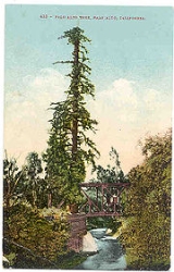
camped near the giant creekside redwood, "El Palo Alto
", November 6–11, 1769, after their momentous discovery of San Francisco Bay. In 1774 Father Francisco Palou
, on Captain Rivera
's expedition, erected a cross at El Palo Alto to mark the site of a proposed mission. The colonizing of the Peninsula began after the 1776 expedition of Juan Bautista De Anza
left Monterey on the first overland expedition to San Francisco Bay, and passed across the creek on its way to establishing Mission Dolores and the Presidio of San Francisco
in 1776. Although de Anza discovered Padre Palou's 1774 wooden cross, the creek's summer flow was deemed too low to support a mission.
above Menlo Park
, around 667 metres (2,188.3 ft) above the Bay. The upper watershed consists of at least 22 named creeks.
The creek mainstem originates at the confluence of Bear Creek
and Corte Madera Creek
just below Searsville Lake
in the Jasper Ridge Biological Preserve
on lands purchased by Stanford University
in 1892. The lake is formed by a dam
built in 1892, one year after the founding of the university itself. The 65 feet (19.8 m) and 275 feet (83.8 m) Searsville Dam consists of a series of interlocking concrete boulders that resemble a massively steep staircase. After leasing the lake for recreational use for 50 years, the Stanford Board of Trustees closed public access to Searsville Lake in 1975. The reservoir has lost over 90% of its original water storage capacity as roughly 1.5 million cubic yards of sediment has filled it in. Searsville Dam
does not provide potable water, flood control, or hydropower. Although removal of the dam would double available spawning habitat on this important steelhead trout stream, Stanford's Jasper Ridge Advisory Committee in 2007 recommended that the dam not be removed and the lake dredged to maintain open water. Stanford University uses water from the lake to irrigate its golf course and other athletic facilities on its campus. Anti-dam proponents point to a growing trend in habitat restoration nationally with over 500 dams removed in recent years.
San Francisquito Creek's mainstem begins below Searsville Lake at the confluence of Corte Madera Creek
and Bear Creek
. It is joined by Los Trancos Creek
just north of Interstate 280
.
The creek runs for a length described by different authorities as from 13 kilometre, most recently 12.5 miles (20.1 km), and after exiting the foothills near Junipero Serra Boulevard and Alpine Road, runs in an incised channel in a broad alluvial fan, before draining into the Bay south of the Dumbarton Bridge and north of the Palo Alto Flood Basin. Its watershed
is about 110 square kilometres (42.5 sq mi) in extent, including areas of San Mateo
and Santa Clara
counties. In one stretch it forms the boundary between the city of Palo Alto
and the cities of East Palo Alto
and Menlo Park
, and thus between San Mateo and Santa Clara counties, reflecting the fact that it was originally used as the boundary between the lands of the Spanish Missions
at San Francisco
and Santa Clara
. The tree from which Palo Alto takes its name, El Palo Alto
, stands on the banks of the creek.
In 1857, the U.S. Coast Survey
(USCS) identified 1142 acres (462.2 ha) of tidal marsh at the mouth of the creek. There were also two large [63 and 118 acre (25.5 and 47.8 ha)] willow groves adjacent to the tidal marsh associated with high groundwater tables and seasonal flooding. In the late 1920s levees were constructed to re-route the creek through a new engineered channel from its former mouth, to a sharp north turn for about half a mile, then to the northeast, before exiting to the Bay. By 2004, filled areas such as the Palo Alto golf course and the Palo Alto Airport
have reduced the tidal marsh to 352 acres (1.4 km²).
(Rana draytonii) and the Western pond turtle
(Actinemys marmorata).
San Francisquito Creek hosts the most viable remaining native Steelhead trout
(Oncorhynchus mykiss) population in the South San Francisco Bay. Bear Creek and Los Trancos Creek and their respective tributaries support an observable steelhead population that is threatened by the effects of urbanization. A May 2002 steelhead trout migration study reported Searsville Dam as the only complete barrier to migration on mainstem San Francisquito Creek (construction of a fishway in 1976 resolved passage at the Lake Lagunita diversion dam 2.5 miles (4 km) below Searsville Dam), and that elimination of the Searsville dam could restore ten miles (16 km) of anadromous steelhead habitat. A genetics study of San Francisquito Creek steelhead in 1996 found that the fish are native and not of hatchery stock. In 2006, an Aquatic Habitat Assessment and Limiting Factors Analysis commissioned by the Santa Clara Valley Water District
concluded that the key factor limiting smolt production within the study area (San Francisquito Creek mainstem and Los Trancos Creek
and potentially throughout the watershed, is a lack of suitable winter refuge in deep pools and large woody debris. Secondly, outgoing salmonid migration is inhibited by seasonal drying and passage impediments.
Several lines of evidence support the historical presence of Coho salmon
(Oncorhynchus kisutch) in San Francisquito Creek. Archaeological remains of unspecified salmonids ("possibly Coho") were reported by Gobalet in the creek. Leidy concluded that coho salmon were likely present and cited that the most suitable habitat for coho salmon was in perennial, well shaded reaches of mainstem San Francisquito Creek, and several small, perennial tributaries including Los Trancos
, Corte Madera
, Bear
, and West Union
creeks. In addition, three independent oral history sources indicate that coho salmon were abundant in the creek through the first half of the twentieth century. According to local historian Dorothy Regnery's notes from her 1966 interview with Edgar H. Batchelder, who was 2 years old when his father became caretaker of Searsville dam in 1897, "When the dam was "wasting", or overflowing, in the winter salmon would swim upstream as far as the base of the dam. Using a pitchfork Mr. Batchelder could spear them to supplement the family's menu." His "favorite place to fish for trout was in the Dennis Martin Creek
". A second source described catching "steelhead and silver (coho) salmon in San Francisquito Creek and the Guadalupe River
System in the 30’s and 40’s. He said that the Guadalupe River also had runs of Chinook salmon
(Oncorhynchus tshawytscha) that were very large in wet years." Thirdly, Dennis L. Bark, a senior fellow at the Hoover Institution
, recalls playing on San Francisquito Creek around 1947: "Salmon swam up it, and in winter it was a dangerous place." The historical range of Coho salmon overlapped geographically with San Francisquito Creek. It is definitely established that Coho salmon were historically present in other San Francisco Bay streams such as San Mateo Creek and Alameda Creek
. Also, the southern limit of Coho salmon in coastal California streams was recently confirmed to extend through Santa Cruz County
based on both archaeological evidence and historically collected specimens.
Besides salmonids, native fish found in the watershed are the California roach
, Sacramento sucker
, Hitch
, Speckled dace
, Three-spined stickleback
, and Prickly sculpin
. Seven nonnative species also exist in the watershed. Three additional species of native fish were present historically: Sacramento perch, last collected in 1960; squawfish, last collected in 1905; and while prickly sculpin have not been collected recently, they may still be present in the upper tributaries.
The flora of the upper watershed consists of scattered oak and madrone woodlands that are intermingled with grassland habitat, in some areas forming a savanna. A grove of upland Coast Redwood (Sequoia sempervirens) forest occurs along San Francisquito Creek just below Searsville Lake. Native tree species that occur in the riparian corridor include valley oak, coast live oak, willows and California buckeyes. Common native riparian shrubs include coffeeberry (Rhamnus californicus), ocean spray (Holodiscus discolor), and creeping snowberry (Symphoricarpos mollis). Within the Jasper Ridge Biological Preserve there are isolated second-generation stands of coast redwood. Other common woody species along the creek banks include the yellow-flowering box elder, big-leaved maple, willows of several species, white alder, California bay and California hazelnut.
; in summer it is usually dry. However, it is capable of flooding, and the risk has become more severe as increased urbanisation along its course has increased the area of impermeable surfaces. In the 1998 El Niño storms, the creek burst its banks; the resulting flood damage in the cities of Palo Alto, Menlo Park and East Palo Alto was estimated at $28 million. The creek's levee
s were also damaged.
The body responsible for the conservation and management of the Mid-Peninsula watersheds, of which the creek is one, is the Santa Clara Valley Water District
. However, because of the significance of the creek in a densely populated area where environmental concerns and recent flooding are both salient in the public mind, a Joint Powers Authority
(JPA) has been formed to address community concerns about the management of the creek. The JPA is currently undertaking or scoping various projects for the improvement of the creek, for example the stabilisation and revegetation of its banks. The members of the JPA are the city councils of Palo Alto, Menlo Park and East Palo Alto, the Santa Clara Valley Water District
, and the San Mateo County Flood Control District. Stanford University
and the San Francisquito Watershed Council are associate members. The latter body is a nonprofit stewardship organization, which is dedicated to fostering the health and diversity of the San Francisquito watershed. This brings together the bodies represented on the JPA with watershed residents, neighborhood associations, environmental organizations, and government agencies at state and federal level, to discuss creek-related concerns and collaborate on creek and watershed stewardship projects. It also organises projects to conserve and study to creek, using the energies of volunteer local residents.
Stream
A stream is a body of water with a current, confined within a bed and stream banks. Depending on its locale or certain characteristics, a stream may be referred to as a branch, brook, beck, burn, creek, "crick", gill , kill, lick, rill, river, syke, bayou, rivulet, streamage, wash, run or...
that flows into southwest San Francisco Bay
San Francisco Bay
San Francisco Bay is a shallow, productive estuary through which water draining from approximately forty percent of California, flowing in the Sacramento and San Joaquin rivers from the Sierra Nevada mountains, enters the Pacific Ocean...
in California
California
California is a state located on the West Coast of the United States. It is by far the most populous U.S. state, and the third-largest by land area...
, United States of America. Historically it was called the Arroyo de San Francisco by Juan Bautista de Anza
Juan Bautista de Anza
Juan Bautista de Anza Bezerra Nieto was a Novo-Spanish explorer and Governor of New Mexico for the Spanish Empire.-Early life:...
in 1776. San Francisquito Creek courses through the towns of Portola Valley and Woodside
Woodside
- Australia :*Woodside, South Australia, a town*Woodside, Victoria, a town*Woodside Petroleum, an Australian company- Canada :*Woodside National Historic Site, the boyhood home of William Lyon Mackenzie King...
, as well as the cities of Menlo Park
Menlo Park, California
Menlo Park, California is a city at the eastern edge of San Mateo County, in the San Francisco Bay Area of California, in the United States. It is bordered by San Francisco Bay on the north and east; East Palo Alto, Palo Alto, and Stanford to the south; Atherton, North Fair Oaks, and Redwood City...
, Palo Alto, and East Palo Alto. The creek and its Los Trancos Creek
Los Trancos Creek
Los Trancos Creek is a creek that flows northerly from Monte Bello Ridge in the Santa Cruz Mountains to its confluence with San Francisquito Creek at Stanford University in California, United States of America...
tributary define the boundary between San Mateo
San Mateo County, California
San Mateo County is a county located in the San Francisco Bay Area of the U.S. state of California. It covers most of the San Francisco Peninsula just south of San Francisco, and north of Santa Clara County. San Francisco International Airport is located at the northern end of the county, and...
and Santa Clara Counties.
History
The original inhabitants were the Ohlone Indians, called by the Spaniards "Coastanoans", or Coast-dwellers. These local residents lived off the land peacefully, gathering nuts, berries and fish from both the ocean and the bay. Because of the abundance of food there was no need for them to practice agriculture. Evidences of their civilization are still being unearthed on the FiloliFiloli
Filoli is a country house set in of formal gardens surrounded by estate, located in Woodside, California, about 25 miles south of San Francisco, at the southern end of Crystal Springs Lake, on the eastern slope of the Santa Cruz Mountains....
estate in Woodside, and along San Francisquito Creek. Spanish rule came when the exploration party led by Don Gaspar de Portola
Gaspar de Portolà
Gaspar de Portolà i Rovira was a soldier, governor of Baja and Alta California , explorer and founder of San Diego and Monterey. He was born in Os de Balaguer, province of Lleida, in Catalonia, Spain, of Catalan nobility. Don Gaspar served as a soldier in the Spanish army in Italy and Portugal...
and including Father Juan Crespi
Juan Crespi
Father Juan Crespí was a Majorcan missionary and explorer of Las Californias. He entered the Franciscan order at the age of seventeen. He came to America in 1749, and accompanied explorers Francisco Palóu and Junípero Serra. In 1767 he went to the Baja Peninsula and was placed in charge of the...
camped near the giant creekside redwood, "El Palo Alto
El Palo Alto
El Palo Alto is a coast redwood tree located in El Palo Alto Park on the banks of San Francisquito Creek in Palo Alto, California, United States...
", November 6–11, 1769, after their momentous discovery of San Francisco Bay. In 1774 Father Francisco Palou
Francisco Palóu
Francesc Palou was a Franciscan missionary, administrator, and historian on the Baja California peninsula and in Alta California. Father Palou's made significant contributions to the Alta California and Baja California mission systems...
, on Captain Rivera
Fernando Rivera y Moncada
Fernando Javier Rivera y Moncada was a soldier from New Spain who served in the Baja California peninsula and upper Las Californias, participating in several early overland explorations. Fernando Rivera y Moncada served as a Spanish Miilitary Governor from 1774-1777. -Biography:Rivera was born...
's expedition, erected a cross at El Palo Alto to mark the site of a proposed mission. The colonizing of the Peninsula began after the 1776 expedition of Juan Bautista De Anza
Juan Bautista de Anza
Juan Bautista de Anza Bezerra Nieto was a Novo-Spanish explorer and Governor of New Mexico for the Spanish Empire.-Early life:...
left Monterey on the first overland expedition to San Francisco Bay, and passed across the creek on its way to establishing Mission Dolores and the Presidio of San Francisco
Presidio of San Francisco
The Presidio of San Francisco is a park on the northern tip of the San Francisco Peninsula in San Francisco, California, within the Golden Gate National Recreation Area...
in 1776. Although de Anza discovered Padre Palou's 1774 wooden cross, the creek's summer flow was deemed too low to support a mission.
Watershed
The headwaters of the San Francisquito watershed are in the Santa Cruz MountainsSanta Cruz Mountains
The Santa Cruz Mountains, part of the Pacific Coast Ranges, are a mountain range in central California, United States. They form a ridge along the San Francisco Peninsula, south of San Francisco, separating the Pacific Ocean from San Francisco Bay and the Santa Clara Valley, and continuing south,...
above Menlo Park
Menlo Park, California
Menlo Park, California is a city at the eastern edge of San Mateo County, in the San Francisco Bay Area of California, in the United States. It is bordered by San Francisco Bay on the north and east; East Palo Alto, Palo Alto, and Stanford to the south; Atherton, North Fair Oaks, and Redwood City...
, around 667 metres (2,188.3 ft) above the Bay. The upper watershed consists of at least 22 named creeks.
The creek mainstem originates at the confluence of Bear Creek
Bear Creek (San Francisquito Creek)
Bear Creek is a southeastward-flowing stream originating north of the summit of Sierra Morena in the Santa Cruz Mountains, near the community of Kings Mountain in San Mateo County, California, United States...
and Corte Madera Creek
Corte Madera Creek (San Mateo County, California)
Corte Madera Creek is a creek that flows north-northwest to Searsville Dam and then joins with Bear Creek to form San Francisquito Creek in California...
just below Searsville Lake
Searsville Dam
Searsville Dam is a masonry dam that was completed in 1892, one year after the founding of Stanford University, and impounds Corte Madera Creek to form a reservoir known as Searsville Lake. Searsville Dam is located in the Jasper Ridge Biological Preserve and is owned and operated by Stanford...
in the Jasper Ridge Biological Preserve
Jasper Ridge Biological Preserve
The Jasper Ridge Biological Preserve is a 1,200 acre is a nature preserve and biological field station owned by Stanford University, located at south of Sand Hill Road and west of Interstate 280 in Portola Valley, California. It is used by students, researchers, and docents to conduct biology...
on lands purchased by Stanford University
Stanford University
The Leland Stanford Junior University, commonly referred to as Stanford University or Stanford, is a private research university on an campus located near Palo Alto, California. It is situated in the northwestern Santa Clara Valley on the San Francisco Peninsula, approximately northwest of San...
in 1892. The lake is formed by a dam
Dam
A dam is a barrier that impounds water or underground streams. Dams generally serve the primary purpose of retaining water, while other structures such as floodgates or levees are used to manage or prevent water flow into specific land regions. Hydropower and pumped-storage hydroelectricity are...
built in 1892, one year after the founding of the university itself. The 65 feet (19.8 m) and 275 feet (83.8 m) Searsville Dam consists of a series of interlocking concrete boulders that resemble a massively steep staircase. After leasing the lake for recreational use for 50 years, the Stanford Board of Trustees closed public access to Searsville Lake in 1975. The reservoir has lost over 90% of its original water storage capacity as roughly 1.5 million cubic yards of sediment has filled it in. Searsville Dam
Searsville Dam
Searsville Dam is a masonry dam that was completed in 1892, one year after the founding of Stanford University, and impounds Corte Madera Creek to form a reservoir known as Searsville Lake. Searsville Dam is located in the Jasper Ridge Biological Preserve and is owned and operated by Stanford...
does not provide potable water, flood control, or hydropower. Although removal of the dam would double available spawning habitat on this important steelhead trout stream, Stanford's Jasper Ridge Advisory Committee in 2007 recommended that the dam not be removed and the lake dredged to maintain open water. Stanford University uses water from the lake to irrigate its golf course and other athletic facilities on its campus. Anti-dam proponents point to a growing trend in habitat restoration nationally with over 500 dams removed in recent years.
San Francisquito Creek's mainstem begins below Searsville Lake at the confluence of Corte Madera Creek
Corte Madera Creek (San Mateo County, California)
Corte Madera Creek is a creek that flows north-northwest to Searsville Dam and then joins with Bear Creek to form San Francisquito Creek in California...
and Bear Creek
Bear Creek (San Francisquito Creek)
Bear Creek is a southeastward-flowing stream originating north of the summit of Sierra Morena in the Santa Cruz Mountains, near the community of Kings Mountain in San Mateo County, California, United States...
. It is joined by Los Trancos Creek
Los Trancos Creek
Los Trancos Creek is a creek that flows northerly from Monte Bello Ridge in the Santa Cruz Mountains to its confluence with San Francisquito Creek at Stanford University in California, United States of America...
just north of Interstate 280
Interstate 280
Interstate 280 may refer to:* Interstate 280 , a north–south freeway running from San Jose to San Francisco* Interstate 280 , part of the beltway around the Quad Cities...
.
The creek runs for a length described by different authorities as from 13 kilometre, most recently 12.5 miles (20.1 km), and after exiting the foothills near Junipero Serra Boulevard and Alpine Road, runs in an incised channel in a broad alluvial fan, before draining into the Bay south of the Dumbarton Bridge and north of the Palo Alto Flood Basin. Its watershed
Drainage basin
A drainage basin is an extent or an area of land where surface water from rain and melting snow or ice converges to a single point, usually the exit of the basin, where the waters join another waterbody, such as a river, lake, reservoir, estuary, wetland, sea, or ocean...
is about 110 square kilometres (42.5 sq mi) in extent, including areas of San Mateo
San Mateo County, California
San Mateo County is a county located in the San Francisco Bay Area of the U.S. state of California. It covers most of the San Francisco Peninsula just south of San Francisco, and north of Santa Clara County. San Francisco International Airport is located at the northern end of the county, and...
and Santa Clara
Santa Clara County, California
Santa Clara County is a county located at the southern end of the San Francisco Bay Area in the U.S. state of California. As of 2010 it had a population of 1,781,642. The county seat is San Jose. The highly urbanized Santa Clara Valley within Santa Clara County is also known as Silicon Valley...
counties. In one stretch it forms the boundary between the city of Palo Alto
Palo Alto, California
Palo Alto is a California charter city located in the northwest corner of Santa Clara County, in the San Francisco Bay Area of California, United States. The city shares its borders with East Palo Alto, Mountain View, Los Altos, Los Altos Hills, Stanford, Portola Valley, and Menlo Park. It is...
and the cities of East Palo Alto
East Palo Alto, California
East Palo Alto is a city in San Mateo County, California, United States.-Overview:As of the 2010 census, the population of East Palo Alto was 28,155. It is situated on the San Francisco Peninsula, roughly halfway between the cities of San Francisco and San Jose...
and Menlo Park
Menlo Park, California
Menlo Park, California is a city at the eastern edge of San Mateo County, in the San Francisco Bay Area of California, in the United States. It is bordered by San Francisco Bay on the north and east; East Palo Alto, Palo Alto, and Stanford to the south; Atherton, North Fair Oaks, and Redwood City...
, and thus between San Mateo and Santa Clara counties, reflecting the fact that it was originally used as the boundary between the lands of the Spanish Missions
Spanish missions in California
The Spanish missions in California comprise a series of religious and military outposts established by Spanish Catholics of the Franciscan Order between 1769 and 1823 to spread the Christian faith among the local Native Americans. The missions represented the first major effort by Europeans to...
at San Francisco
Mission San Francisco de Asís
Mission San Francisco de Asís, or Mission Dolores, is the oldest surviving structure in San Francisco and the sixth religious settlement established as part of the California chain of missions...
and Santa Clara
Mission Santa Clara de Asís
Mission Santa Clara de Asís was founded on January 12, 1777 and named for Santa Clara de Asis , the foundress of the order of the Poor Clares. Although ruined and rebuilt six times, the settlement was never abandoned.-History:...
. The tree from which Palo Alto takes its name, El Palo Alto
El Palo Alto
El Palo Alto is a coast redwood tree located in El Palo Alto Park on the banks of San Francisquito Creek in Palo Alto, California, United States...
, stands on the banks of the creek.
In 1857, the U.S. Coast Survey
U.S. National Geodetic Survey
National Geodetic Survey, formerly called the U.S. Coast and Geodetic Survey , is a United States federal agency that defines and manages a national coordinate system, providing the foundation for transportation and communication; mapping and charting; and a large number of applications of science...
(USCS) identified 1142 acres (462.2 ha) of tidal marsh at the mouth of the creek. There were also two large [63 and 118 acre (25.5 and 47.8 ha)] willow groves adjacent to the tidal marsh associated with high groundwater tables and seasonal flooding. In the late 1920s levees were constructed to re-route the creek through a new engineered channel from its former mouth, to a sharp north turn for about half a mile, then to the northeast, before exiting to the Bay. By 2004, filled areas such as the Palo Alto golf course and the Palo Alto Airport
Palo Alto Airport of Santa Clara County
Palo Alto Airport of Santa Clara County is a general aviation airport in the city of Palo Alto in Santa Clara County, California, USA, near the south end of San Francisco Bay on the western shore.- Facilities :...
have reduced the tidal marsh to 352 acres (1.4 km²).
Ecology
Riparian fauna include threatened species such as the threatened California Red-legged FrogCalifornia Red-legged Frog
The California red-legged frog, Rana draytonii, is a moderate to large species of frog. It is known under the scientific name Rana draytonii, after being long included with the northern red-legged frog The California red-legged frog, Rana draytonii, is a moderate to large (4.4–14 cm) species...
(Rana draytonii) and the Western pond turtle
Western pond turtle
The western pond turtle , or Pacific pond turtle is a small to medium-sized turtle growing to approximately 20 cm in carapace length. It is limited to the west coast of the United States of America and Mexico, ranging from western Washington state to northern Baja California...
(Actinemys marmorata).
San Francisquito Creek hosts the most viable remaining native Steelhead trout
Rainbow trout
The rainbow trout is a species of salmonid native to tributaries of the Pacific Ocean in Asia and North America. The steelhead is a sea run rainbow trout usually returning to freshwater to spawn after 2 to 3 years at sea. In other words, rainbow trout and steelhead trout are the same species....
(Oncorhynchus mykiss) population in the South San Francisco Bay. Bear Creek and Los Trancos Creek and their respective tributaries support an observable steelhead population that is threatened by the effects of urbanization. A May 2002 steelhead trout migration study reported Searsville Dam as the only complete barrier to migration on mainstem San Francisquito Creek (construction of a fishway in 1976 resolved passage at the Lake Lagunita diversion dam 2.5 miles (4 km) below Searsville Dam), and that elimination of the Searsville dam could restore ten miles (16 km) of anadromous steelhead habitat. A genetics study of San Francisquito Creek steelhead in 1996 found that the fish are native and not of hatchery stock. In 2006, an Aquatic Habitat Assessment and Limiting Factors Analysis commissioned by the Santa Clara Valley Water District
Santa Clara Valley Water District
The Santa Clara Valley Water District provides stream stewardship, wholesale water supply and flood protection for Santa Clara County, California, in the southern San Francisco Bay Area. The district encompasses all of the county’s and serves the area’s 15 cities, 1.7 million residents and more...
concluded that the key factor limiting smolt production within the study area (San Francisquito Creek mainstem and Los Trancos Creek
Los Trancos Creek
Los Trancos Creek is a creek that flows northerly from Monte Bello Ridge in the Santa Cruz Mountains to its confluence with San Francisquito Creek at Stanford University in California, United States of America...
and potentially throughout the watershed, is a lack of suitable winter refuge in deep pools and large woody debris. Secondly, outgoing salmonid migration is inhibited by seasonal drying and passage impediments.
Several lines of evidence support the historical presence of Coho salmon
Coho salmon
The Coho salmon, Oncorhynchus kisutch, is a species of anadromous fish in the salmon family. Coho salmon are also known as silver salmon or "silvers". It is the state animal of Chiba, Japan.-Description:...
(Oncorhynchus kisutch) in San Francisquito Creek. Archaeological remains of unspecified salmonids ("possibly Coho") were reported by Gobalet in the creek. Leidy concluded that coho salmon were likely present and cited that the most suitable habitat for coho salmon was in perennial, well shaded reaches of mainstem San Francisquito Creek, and several small, perennial tributaries including Los Trancos
Los Trancos Creek
Los Trancos Creek is a creek that flows northerly from Monte Bello Ridge in the Santa Cruz Mountains to its confluence with San Francisquito Creek at Stanford University in California, United States of America...
, Corte Madera
Corte Madera Creek (San Mateo County, California)
Corte Madera Creek is a creek that flows north-northwest to Searsville Dam and then joins with Bear Creek to form San Francisquito Creek in California...
, Bear
Bear Creek (San Francisquito Creek)
Bear Creek is a southeastward-flowing stream originating north of the summit of Sierra Morena in the Santa Cruz Mountains, near the community of Kings Mountain in San Mateo County, California, United States...
, and West Union
West Union Creek
West Union Creek is a stream originating on the east slope of Kings Mountain in the Santa Cruz Mountains, in San Mateo County, California, United States...
creeks. In addition, three independent oral history sources indicate that coho salmon were abundant in the creek through the first half of the twentieth century. According to local historian Dorothy Regnery's notes from her 1966 interview with Edgar H. Batchelder, who was 2 years old when his father became caretaker of Searsville dam in 1897, "When the dam was "wasting", or overflowing, in the winter salmon would swim upstream as far as the base of the dam. Using a pitchfork Mr. Batchelder could spear them to supplement the family's menu." His "favorite place to fish for trout was in the Dennis Martin Creek
Martin Creek
Martin Creek, known locally as Dennis Martin Creek, is a north by northeastward-flowing stream originating just east of Skyline Boulevard in the Santa Cruz Mountains, near the community of Skylonda in San Mateo County, California, United States. It flows through the town of Woodside before...
". A second source described catching "steelhead and silver (coho) salmon in San Francisquito Creek and the Guadalupe River
Guadalupe River (California)
The Guadalupe River is a short river in California whose headwater creeks originate in the Santa Cruz Mountains near the summit of Loma Prieta and Mount Umunhum. The river mainstem now begins on the Santa Clara Valley floor at the northern end of Lake Almaden, which is fed by Los Alamitos Creek and...
System in the 30’s and 40’s. He said that the Guadalupe River also had runs of Chinook salmon
Chinook salmon
The Chinook salmon, Oncorhynchus tshawytscha, is the largest species in the pacific salmon family. Other commonly used names for the species include King salmon, Quinnat salmon, Spring salmon and Tyee salmon...
(Oncorhynchus tshawytscha) that were very large in wet years." Thirdly, Dennis L. Bark, a senior fellow at the Hoover Institution
Hoover Institution
The Hoover Institution on War, Revolution and Peace is a public policy think tank and library founded in 1919 by then future U.S. president, Herbert Hoover, an early alumnus of Stanford....
, recalls playing on San Francisquito Creek around 1947: "Salmon swam up it, and in winter it was a dangerous place." The historical range of Coho salmon overlapped geographically with San Francisquito Creek. It is definitely established that Coho salmon were historically present in other San Francisco Bay streams such as San Mateo Creek and Alameda Creek
Alameda Creek
Alameda Creek is a large perennial stream in the San Francisco Bay Area. The creek runs for from a lake northeast of Packard Ridge to the eastern shore San Francisco Bay by way of Niles Canyon and a flood control channel.-History:...
. Also, the southern limit of Coho salmon in coastal California streams was recently confirmed to extend through Santa Cruz County
Santa Cruz County, California
Santa Cruz County is a county located on the Pacific coast of the U.S. state of California, on the California Central Coast. The county forms the northern coast of the Monterey Bay. . As of the 2010 U.S. Census, its population was 262,382. The county seat is Santa Cruz...
based on both archaeological evidence and historically collected specimens.
Besides salmonids, native fish found in the watershed are the California roach
California roach
The California roach, Hesperoleucus symmetricus, is a cyprinid fish native to western North America and abundant in the intermittent streams throughout central California. It is the sole member of its genus....
, Sacramento sucker
Catostomidae
Catostomidae is the sucker family of the order Cypriniformes. There are 80 species in this family of freshwater fishes. Catostomidae are found in North America, east central China, and eastern Siberia...
, Hitch
Lavinia exilicauda
The hitch Lavinia exilicauda is a cyprinid fish endemic to central California, and once very common. The name is derived from the Pomoan word for this species....
, Speckled dace
Speckled dace
The speckled dace , also known as the spotted dace and the carpita pinta, is a member of the carp family. It is found in temperate freshwater in North America, from Sonora to British Columbia....
, Three-spined stickleback
Three-spined stickleback
The three-spined stickleback, Gasterosteus aculeatus, is a fish native to much of northern Europe, northern Asia and North America. It has been introduced into parts of southern and central Europe.-Distribution and morphological variation:...
, and Prickly sculpin
Cottus (genus)
Cottus is a genus of the sculpin family Cottidae. It is often referred to as the "freshwater sculpins", as the principal genus of sculpins to be found in fresh water.They are mostly small fish, rarely reaching more than 15 cm in length.-Species:...
. Seven nonnative species also exist in the watershed. Three additional species of native fish were present historically: Sacramento perch, last collected in 1960; squawfish, last collected in 1905; and while prickly sculpin have not been collected recently, they may still be present in the upper tributaries.
The flora of the upper watershed consists of scattered oak and madrone woodlands that are intermingled with grassland habitat, in some areas forming a savanna. A grove of upland Coast Redwood (Sequoia sempervirens) forest occurs along San Francisquito Creek just below Searsville Lake. Native tree species that occur in the riparian corridor include valley oak, coast live oak, willows and California buckeyes. Common native riparian shrubs include coffeeberry (Rhamnus californicus), ocean spray (Holodiscus discolor), and creeping snowberry (Symphoricarpos mollis). Within the Jasper Ridge Biological Preserve there are isolated second-generation stands of coast redwood. Other common woody species along the creek banks include the yellow-flowering box elder, big-leaved maple, willows of several species, white alder, California bay and California hazelnut.
Conservation
In normal winters the creek runs sluggishly in a deep arroyoArroyo (creek)
An arroyo , a Spanish word translated as brook, and also called a wash is usually a dry creek or stream bed—gulch that temporarily or seasonally fills and flows after sufficient rain. Wadi is a similar term in Africa. In Spain, a rambla has a similar meaning to arroyo.-Types and processes:Arroyos...
; in summer it is usually dry. However, it is capable of flooding, and the risk has become more severe as increased urbanisation along its course has increased the area of impermeable surfaces. In the 1998 El Niño storms, the creek burst its banks; the resulting flood damage in the cities of Palo Alto, Menlo Park and East Palo Alto was estimated at $28 million. The creek's levee
Levee
A levee, levée, dike , embankment, floodbank or stopbank is an elongated naturally occurring ridge or artificially constructed fill or wall, which regulates water levels...
s were also damaged.
The body responsible for the conservation and management of the Mid-Peninsula watersheds, of which the creek is one, is the Santa Clara Valley Water District
Santa Clara Valley Water District
The Santa Clara Valley Water District provides stream stewardship, wholesale water supply and flood protection for Santa Clara County, California, in the southern San Francisco Bay Area. The district encompasses all of the county’s and serves the area’s 15 cities, 1.7 million residents and more...
. However, because of the significance of the creek in a densely populated area where environmental concerns and recent flooding are both salient in the public mind, a Joint Powers Authority
Joint Powers Authority
A Joint Powers Authority is an entity permitted under the laws of some states of the USA, whereby two or more public authorities can operate collectively. Joint Powers Authorities may be used where:*an activity naturally transcends the boundaries of existing public authorities...
(JPA) has been formed to address community concerns about the management of the creek. The JPA is currently undertaking or scoping various projects for the improvement of the creek, for example the stabilisation and revegetation of its banks. The members of the JPA are the city councils of Palo Alto, Menlo Park and East Palo Alto, the Santa Clara Valley Water District
Santa Clara Valley Water District
The Santa Clara Valley Water District provides stream stewardship, wholesale water supply and flood protection for Santa Clara County, California, in the southern San Francisco Bay Area. The district encompasses all of the county’s and serves the area’s 15 cities, 1.7 million residents and more...
, and the San Mateo County Flood Control District. Stanford University
Stanford University
The Leland Stanford Junior University, commonly referred to as Stanford University or Stanford, is a private research university on an campus located near Palo Alto, California. It is situated in the northwestern Santa Clara Valley on the San Francisco Peninsula, approximately northwest of San...
and the San Francisquito Watershed Council are associate members. The latter body is a nonprofit stewardship organization, which is dedicated to fostering the health and diversity of the San Francisquito watershed. This brings together the bodies represented on the JPA with watershed residents, neighborhood associations, environmental organizations, and government agencies at state and federal level, to discuss creek-related concerns and collaborate on creek and watershed stewardship projects. It also organises projects to conserve and study to creek, using the energies of volunteer local residents.
External links
- Beyond Searsville Dam
- Santa Clara Valley Water District web site
- San Francisquito Creek Joint Powers Authority
- San Francisquito Watershed Council
- US Geological Service project on the creek
- Information about the conservation issues on the creek on the Save The Bay website
- Guide to the Creek prepared by the Oakland Museum of CaliforniaOakland Museum of CaliforniaOakland Museum of California or Oakland Museum is a museum dedicated to the art, history, and natural science of California located in Oakland, California....
- live images of San Francisquito Creek at West Bayshore Road in Palo Alto
- current depth information for Palo Alto creeks, including San Francisquito Creek