
Palo Alto Airport of Santa Clara County
Encyclopedia
Palo Alto Airport of Santa Clara County is a general aviation
airport
in the city of Palo Alto
in Santa Clara County
, California
, USA
, near the south end of San Francisco Bay
on the western shore.
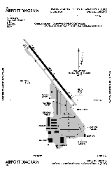
paved runway
(13/31) measuring 2,443 x 70 ft. (745 x 21 m).
First time pilots should familiarize themselves with the complex SF Bay Area airspace, especially the overlying SFO
Class B and the abutting SJC
Class C airspace. Landing pilots should also watch out for bird and jackrabbit activity.
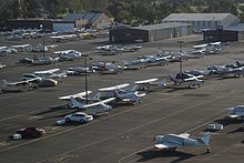
Facilities at this busy towered airport include multiple aircraft repair shops and a staffed terminal. The airport is located within one-half mile of U.S. Route 101.
Fifteen miles of hiking and biking trails, affording multiple opportunities for birdwatching, form part of the adjacent 1940 acres (785 ha) Palo Alto Baylands Nature Preserve. The airport is also adjacent to a public golf course. Dining options within a short walk include the Abundant Air Cafe, the Bay Cafe at the Golf Course and the popular Ming's Restaurant.
The VOR approach is almost impossible to get from ATC if you are GPS-equipped, because of the conflict with airline traffic in San Jose International.
Comparison of the aerial photographs indicate that no development had begun in the vicinity prior to 1956 other than the Palo Alto Airport and the Regional Water Quality Control Board Plant (terminus of Embarcadero Way). Between 1956 and 1960, no new development had taken place in the area; however, by 1973, the Harvey Gum Factory was on the subject site and structures were either completed or under construction at 1890 Embarcadero Road and 2440-2450 Embarcadero Way. Conditions were identical in the 1974 aerial photograph. In the 1980 aerial photograph, the Harvey Gum Factory is standing, and additional infill construction can be seen in the area such as the Baylands Business Park adjacent and to south of the site and the structure now located at 1860 Embarcadero Road. The Harvey Gum Factory was demolished in 1982, based upon Palo Alto
Planning Department records.
s were the primary trainer used. Also had several PT-17 Stearmans and a few P-40 Warhawks assigned. There may have been as many as six auxiliary airfields in the area used for emergency and overflow landings during its USAAF use.
Transferred to the United States Navy as King City NAAS in April 1945. Returned to civil control in December 1945.
General aviation
General aviation is one of the two categories of civil aviation. It refers to all flights other than military and scheduled airline and regular cargo flights, both private and commercial. General aviation flights range from gliders and powered parachutes to large, non-scheduled cargo jet flights...
airport
Airport
An airport is a location where aircraft such as fixed-wing aircraft, helicopters, and blimps take off and land. Aircraft may be stored or maintained at an airport...
in the city of Palo Alto
Palo Alto, California
Palo Alto is a California charter city located in the northwest corner of Santa Clara County, in the San Francisco Bay Area of California, United States. The city shares its borders with East Palo Alto, Mountain View, Los Altos, Los Altos Hills, Stanford, Portola Valley, and Menlo Park. It is...
in Santa Clara County
Santa Clara County, California
Santa Clara County is a county located at the southern end of the San Francisco Bay Area in the U.S. state of California. As of 2010 it had a population of 1,781,642. The county seat is San Jose. The highly urbanized Santa Clara Valley within Santa Clara County is also known as Silicon Valley...
, California
California
California is a state located on the West Coast of the United States. It is by far the most populous U.S. state, and the third-largest by land area...
, USA
United States
The United States of America is a federal constitutional republic comprising fifty states and a federal district...
, near the south end of San Francisco Bay
San Francisco Bay
San Francisco Bay is a shallow, productive estuary through which water draining from approximately forty percent of California, flowing in the Sacramento and San Joaquin rivers from the Sierra Nevada mountains, enters the Pacific Ocean...
on the western shore.
Facilities
Palo Alto Airport of Santa Clara County covers 102 acres (41 ha) and has one asphaltAsphalt
Asphalt or , also known as bitumen, is a sticky, black and highly viscous liquid or semi-solid that is present in most crude petroleums and in some natural deposits, it is a substance classed as a pitch...
paved runway
Runway
According to ICAO a runway is a "defined rectangular area on a land aerodrome prepared for the landing and take-off of aircraft." Runways may be a man-made surface or a natural surface .- Orientation and dimensions :Runways are named by a number between 01 and 36, which is generally one tenth...
(13/31) measuring 2,443 x 70 ft. (745 x 21 m).
First time pilots should familiarize themselves with the complex SF Bay Area airspace, especially the overlying SFO
San Francisco International Airport
San Francisco International Airport is a major international airport located south of downtown San Francisco, California, United States, near the cities of Millbrae and San Bruno in unincorporated San Mateo County. It is often referred to as SFO...
Class B and the abutting SJC
San Jose International Airport
Norman Y. Mineta San Jose International Airport is a city-owned public-use airport serving the city of San Jose in Santa Clara County, California, United States. It is named for San Jose native Norman Yoshio Mineta, who was Transportation Secretary in the Cabinet of George W...
Class C airspace. Landing pilots should also watch out for bird and jackrabbit activity.
Facilities at this busy towered airport include multiple aircraft repair shops and a staffed terminal. The airport is located within one-half mile of U.S. Route 101.
Fifteen miles of hiking and biking trails, affording multiple opportunities for birdwatching, form part of the adjacent 1940 acres (785 ha) Palo Alto Baylands Nature Preserve. The airport is also adjacent to a public golf course. Dining options within a short walk include the Abundant Air Cafe, the Bay Cafe at the Golf Course and the popular Ming's Restaurant.
Instrument Approaches
Palo Alto airport has two approaches, both to runway 31 with 460' MDA/ 1-mi visibility minimums:- GPS Runway 31
- VOR/DME Runway 31 from San Jose VOR
The VOR approach is almost impossible to get from ATC if you are GPS-equipped, because of the conflict with airline traffic in San Jose International.
Area history
In 1989 a comprehensive area history analysis was conducted by Earth Metrics, based upon review of extant aerial photographs.(Earth Metrics, 1989) The photo reconnaissance flights were flown in 1956, 1960, 1973, 1974 and 1980 by the U.S. Department of the Interior, and are archived by the U.S. Geological Survey in Menlo Park, California.Comparison of the aerial photographs indicate that no development had begun in the vicinity prior to 1956 other than the Palo Alto Airport and the Regional Water Quality Control Board Plant (terminus of Embarcadero Way). Between 1956 and 1960, no new development had taken place in the area; however, by 1973, the Harvey Gum Factory was on the subject site and structures were either completed or under construction at 1890 Embarcadero Road and 2440-2450 Embarcadero Way. Conditions were identical in the 1974 aerial photograph. In the 1980 aerial photograph, the Harvey Gum Factory is standing, and additional infill construction can be seen in the area such as the Baylands Business Park adjacent and to south of the site and the structure now located at 1860 Embarcadero Road. The Harvey Gum Factory was demolished in 1982, based upon Palo Alto
Palo Alto, California
Palo Alto is a California charter city located in the northwest corner of Santa Clara County, in the San Francisco Bay Area of California, United States. The city shares its borders with East Palo Alto, Mountain View, Los Altos, Los Altos Hills, Stanford, Portola Valley, and Menlo Park. It is...
Planning Department records.
World War II
The airport was opened to the public in April 1940. Taken over by the United States Army Air Force on 22 March 1941 as a basic (level 1) pilot training airfield. Assigned to USAAF West Coast Training Center (later Western Flying Training Command). Conducted contract basic flying training. Fairchild PT-19Fairchild PT-19
|-See also:-Bibliography:* Mondey, David. American Aircraft of World War II . London: Bounty Books, 2006. ISBN 978-0-7537-1461-4....
s were the primary trainer used. Also had several PT-17 Stearmans and a few P-40 Warhawks assigned. There may have been as many as six auxiliary airfields in the area used for emergency and overflow landings during its USAAF use.
Transferred to the United States Navy as King City NAAS in April 1945. Returned to civil control in December 1945.
See also
- List of attractions in Silicon Valley
- Reid-Hillview Airport
- South County AirportSouth County AirportSouth County Airport of Santa Clara County, colloquially South County Airport, is a public non-towered airport located one mile east of San Martin, serving Santa Clara County, California, U.S.A. This general aviation airport covers and has one runway. A self-service fueling facility offers...
- List of airports in the San Francisco Bay area
- California World War II Army AirfieldsCalifornia World War II Army AirfieldsDuring World War II, the United States Army Air Forces established numerous airfields in California for training pilots and aircrews of USAAF fighters and bombers.-Overview:...
Sources
- Shaw, Frederick J. (2004), Locating Air Force Base Sites History’s Legacy, Air Force History and Museums Program, United States Air Force, Washington DC, 2004.
- Manning, Thomas A. (2005), History of Air Education and Training Command, 1942–2002. Office of History and Research, Headquarters, AETC, Randolph AFB, Texas ASIN: B000NYX3PC
Further reading
- Santa Clara County Airports Official Site: Palo Alto Airport
- Earth Metrics. Inc, "Phase One Environmental Site Assessment, 1870 Embarcadero Road, Palo Alto", Report No. 7897W0.001, June 2, 1989
External links