

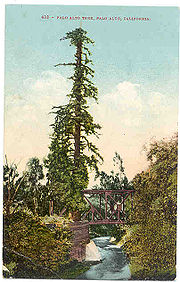
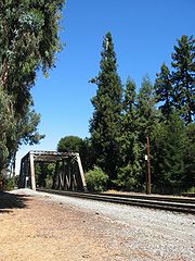
El Palo Alto
Encyclopedia
Tree
A tree is a perennial woody plant. It is most often defined as a woody plant that has many secondary branches supported clear of the ground on a single main stem or trunk with clear apical dominance. A minimum height specification at maturity is cited by some authors, varying from 3 m to...
located in El Palo Alto Park on the banks of San Francisquito Creek
San Francisquito Creek
San Francisquito Creek is a creek that flows into southwest San Francisco Bay in California, United States of America. Historically it was called the Arroyo de San Francisco by Juan Bautista de Anza in 1776...
in Palo Alto, California
Palo Alto, California
Palo Alto is a California charter city located in the northwest corner of Santa Clara County, in the San Francisco Bay Area of California, United States. The city shares its borders with East Palo Alto, Mountain View, Los Altos, Los Altos Hills, Stanford, Portola Valley, and Menlo Park. It is...
, United States
United States
The United States of America is a federal constitutional republic comprising fifty states and a federal district...
. El Palo Alto means the tall stick in Spanish
Spanish language
Spanish , also known as Castilian , is a Romance language in the Ibero-Romance group that evolved from several languages and dialects in central-northern Iberia around the 9th century and gradually spread with the expansion of the Kingdom of Castile into central and southern Iberia during the...
.
Arroyo (creek)
An arroyo , a Spanish word translated as brook, and also called a wash is usually a dry creek or stream bed—gulch that temporarily or seasonally fills and flows after sufficient rain. Wadi is a similar term in Africa. In Spain, a rambla has a similar meaning to arroyo.-Types and processes:Arroyos...
downed one of the two trunks.
History
The tree is California Historical LandmarkCalifornia Historical Landmark
California Historical Landmarks are buildings, structures, sites, or places in the state of California that have been determined to have statewide historical significance by meeting at least one of the criteria listed below:...
No. 2 (number 1 is the custom house in Monterey
Monterey, California
The City of Monterey in Monterey County is located on Monterey Bay along the Pacific coast in Central California. Monterey lies at an elevation of 26 feet above sea level. As of the 2010 census, the city population was 27,810. Monterey is of historical importance because it was the capital of...
). It is recognized by the National Arborist Association and International Society of Arboriculture for its historical significance as "a campsite for the Portola
Gaspar de Portolà
Gaspar de Portolà i Rovira was a soldier, governor of Baja and Alta California , explorer and founder of San Diego and Monterey. He was born in Os de Balaguer, province of Lleida, in Catalonia, Spain, of Catalan nobility. Don Gaspar served as a soldier in the Spanish army in Italy and Portugal...
Expedition Party of 1769"; being frequented by the Costanoan/Ohlone
Ohlone
The Ohlone people, also known as the Costanoan, are a Native American people of the central California coast. When Spanish explorers and missionaries arrived in the late 18th century, the Ohlone inhabited the area along the coast from San Francisco Bay through Monterey Bay to the lower Salinas Valley...
Indians; and for its use as a sighting tree by surveyors
Surveying
See Also: Public Land Survey SystemSurveying or land surveying is the technique, profession, and science of accurately determining the terrestrial or three-dimensional position of points and the distances and angles between them...
plotting out El Camino Real
El Camino Real (California)
El Camino Real and sometimes associated with Calle Real usually refers to the 600-mile California Mission Trail, connecting the former Alta California's 21 missions , 4 presidios, and several pueblos, stretching from Mission San Diego de Alcalá in San Diego...
. The tree is depicted on the city of Palo Alto's official seal and on the seal of Stanford University
Stanford University
The Leland Stanford Junior University, commonly referred to as Stanford University or Stanford, is a private research university on an campus located near Palo Alto, California. It is situated in the northwestern Santa Clara Valley on the San Francisco Peninsula, approximately northwest of San...
. It is presumably the origin of the city's name.
A plaque at the base of the tree bears the following inscription:
- Under this giant redwood, the Palo Alto, November 6–11, 1769, camped PortolaGaspar de PortolàGaspar de Portolà i Rovira was a soldier, governor of Baja and Alta California , explorer and founder of San Diego and Monterey. He was born in Os de Balaguer, province of Lleida, in Catalonia, Spain, of Catalan nobility. Don Gaspar served as a soldier in the Spanish army in Italy and Portugal...
and his band on the expedition that discovered San Francisco Bay, this was the assembling point for their reconnoitering parties. Here in 1774 Padre PalouFrancisco PalóuFrancesc Palou was a Franciscan missionary, administrator, and historian on the Baja California peninsula and in Alta California. Father Palou's made significant contributions to the Alta California and Baja California mission systems...
erected a cross to mark the site of a proposed mission. The celebrated Pedro Font topographical map of 1776 contained the drawing of the original double trunked tree making the Palo Alto the first official living California landmark.
It was two years after Padre Palou's visit that Padre Font, on the De Anza Expedition
Juan Bautista de Anza
Juan Bautista de Anza Bezerra Nieto was a Novo-Spanish explorer and Governor of New Mexico for the Spanish Empire.-Early life:...
's way back to Mexico after founding San Francisco, measured the giant redwood "five and a half yards around" in his diary on March 30, 1776. Also at El Palo Alto, de Anza and Font found the wooden cross that Palou had placed two years earlier, but de Anza decided to move the mission location to Santa Clara because San Francisquito Creek's water was too low in the dry season.
Health of the tree and conservation
In 1776, the tree was measured at 135.7-feet with a circumference of 15.1-feet. In 1814, measurement found a height of 162.2 feet. However, from 1865–1955, the tree's health was in decline exhibiting sparse branching and foliage. In 1926, fearing loss of the tree, a bronze plaque commemorating the tree was set in a granite boulder by the local Native Sons of the Golden WestNative Sons of the Golden West
-History:The Native Sons of the Golden West was founded July 11, 1875 by General A. M. Winn, a Virginian, as a lasting monument to the men and women of the Gold Rush Days...
. In 1951 its height was 134.6 feet, in 1977 its height was reduced to 126 feet to remove the dead top, and again in 1999 where it still stands at nearly 110 feet in height. Causes of the tree's decline have been attributed to coal-burning train soot and lowering of the water table by nearby orchard wells, including the 1912 Tower Well only two blocks away. By the 1960s, the water table was so low that salt water was intruding into nearby wells and Peninsula cities like Palo Alto switched to getting their water from the Hetch Hetchy
Hetch Hetchy Aqueduct
The Hetch Hetchy Aqueduct is a conveyance of Tuolumne River water runoff from federal lands in Yosemite National Park to San Francisco and its client municipalities in the greater San Francisco Bay Area...
system. El Palo Alto was unable access the lowered groundwater as redwoods are typically shallow rooted. By the mid-1960s the tree was in severe decline, leading to successive dying off of the treetop until the water table began to recover in the late 1990s. Efforts to restore the tree's health by the Southern Pacific Railroad
Southern Pacific Railroad
The Southern Pacific Transportation Company , earlier Southern Pacific Railroad and Southern Pacific Company, and usually simply called the Southern Pacific or Espee, was an American railroad....
, the City of Palo Alto and local citizens included progressive pruning off of the dying treetop, addition of soil and mulch at the tree’s base, removal of dead limbs, pesticide spraying and installation of a pipe up its trunk to bring water to the top of the tree. Although the tree stands today at only 68% of its former stature, it enjoys greater health than nearly a century ago.
A 1999 horticultural appraisal of El Palo Alto, conducted in accordance with the Guide for Plant Appraisal authored by the Council of Tree and Landscape Appraisers and published by the International Society of Arboriculture, valued the tree at $55,600.00.
In 2004, seedlings from El Palo Alto were planted in the American Forests
American Forests
American Forests is a 501 non-profit conservation organization dedicated to protecting and restoring healthy forest ecosystems. Their stated mission is to "grow a healthier world with trees". The organization was established in 1875 as the American Forestry Association by physician and...
Historic Tree Nursery in Jacksonville, Florida
Jacksonville, Florida
Jacksonville is the largest city in the U.S. state of Florida in terms of both population and land area, and the largest city by area in the contiguous United States. It is the county seat of Duval County, with which the city government consolidated in 1968...
.
The tree was spray-painted with graffiti
Graffiti
Graffiti is the name for images or lettering scratched, scrawled, painted or marked in any manner on property....
in August 2010, but was subsequently cleaned.