
Sagaing Division
Encyclopedia
Sagaing Region is an administrative region
of Burma (Myanmar), located in the north-western part of the country between latitude 21° 30' north and longitude 94° 97' east. It is bordered by India
’s Nagaland
and Manipur
States to the north, Kachin State
, Shan State
, and Mandalay Region to the east, Mandalay Region and Magway Region to the south, with the Ayeyarwady River
forming a greater part of its eastern and also southern boundary, and Chin State
and India to the west. The region has an area of 93,527 km², and population (1996) of over 5,300,000. The capital is Sagaing
.
first migrated into Upper Myanmar by 9th century CE. The area came under the Pagan Kingdom
certainly by the middle of 11th century when King Anawrahta
(r. 1044-1077) founded the Pagan Empire, which encompasses the modern day Myanmar.
After the fall of Pagan in 1287, the northwestern parts of Upper Myanmar came under the Sagaing Kingdom (1315–1364) ruled by Burmanized Shan kings. The area was ruled by the kings of Ava
from 1364 to 1555 and the kings of Taungoo from 1555 to 1752. Konbaung Dynasty
(1752–1885), founded by king Alaungpaya
in Shwebo
, became the last Burmese dynasty before the British
conquest of Upper Burma in 1885. The area became Sagaing Division after the Burmese independence in January 1948.
, Monywa
, Shwebo
, Katha
, Kale
, Tamu, Mawlaik
and Hkamti. Mingun
with its famous bell is located near Sagaing but can be reached across the Ayeyarwady from Mandalay
. The districts are Sagaing
, Shwebo
, Monywa
, Katha
, Kale (Kalemyo)
, Tamu
, Mawlaik
and Hkamti
. The townships are:
In August 2010, three former townships of Sagaing Region were transferred, in accordance with the 2008 constitution, to a new administrative unit the Naga Self-Administered Zone
which is no longer part of Sagaing Region. Those townships were Lahe
, Leshi
and Nanyun
.
in the dry regions and along the Mandalay-Myitkyina
Railroad. Shan live in the upper Chindwin River
valley. A sizable minority of Naga
resides in the north of north-west mountain ranges and Chin
in the south. Smaller ethnic groups native to the Region include the Kadu and Ganang, who live in the upper Mu River valley and Meza River valley.
, Chatthin Wildlife Sanctuary
, Mahamyaing Wildlife Sanctuary, and Htamanthi Wildlife Sanctuary
in Homalin Township
.
 Hemmed in by two great rivers of Myanmar, the Ayeyarwady
and the Chindwin
, river transport is a common way to move people and cargo. Much of the inland Sagaing Region relies on roads and rail in poor condition.
, which occupies most of the arable ground. Other crops include wheat
, sesame
, peanut
, pulses, cotton
, and tobacco
. Sagaing is Myanmar’s leading producer of wheat, contributing more than 80% of the country's total production. Forestry is important in the wetter upper regions along the Chindwin River
, with teak
and other hardwoods extracted. As in other parts of the country, reforestation
is not effective enough to maintain sustainable forestry. Important minerals include gold
, coal
, salt
and small amounts of petroleum
. Industry includes textiles, copper
refining, gold smelting, and a diesel engine
plant. The Region has many rice mills, edible oil mills, saw mills, cotton mills, and mechanized weaving factories. Local industry includes earthen pots, silverware, bronze-wares, iron-wares and lacquerware
.
and Mandalay
. According to official statistics, less than 10% of primary school students in Sagaing Region reach high school.
Sagaing Region has two national "professional" universities in the Monywa Institute of Economics
and the Sagaing Institute of Education
. Monywa University is the main liberal arts
university in the region.
and Mandalay
is extremely poor. In 2003, Sagaing Region had less than a quarter of hospital beds than Yangon Region with a similar size of population.
Administrative divisions of Myanmar
Burma is divided into twenty-one administrative subdivisions, which include* seven states ,* seven regions ,* five self-administered zones and* one self-administered division ....
of Burma (Myanmar), located in the north-western part of the country between latitude 21° 30' north and longitude 94° 97' east. It is bordered by India
India
India , officially the Republic of India , is a country in South Asia. It is the seventh-largest country by geographical area, the second-most populous country with over 1.2 billion people, and the most populous democracy in the world...
’s Nagaland
Nagaland
Nagaland is a state in the far north-eastern part of India. It borders the state of Assam to the west, Arunachal Pradesh and part of Assam to the north, Burma to the east and Manipur to the south. The state capital is Kohima, and the largest city is Dimapur...
and Manipur
Manipur
Manipur is a state in northeastern India, with the city of Imphal as its capital. Manipur is bounded by the Indian states of Nagaland to the north, Mizoram to the south and Assam to the west; it also borders Burma to the east. It covers an area of...
States to the north, Kachin State
Kachin State
Kachin State , is the northernmost state of Burma. It is bordered by China to the north and east; Shan State to the south; and Sagaing Division and India to the west. It lies between north latitude 23° 27' and 28° 25' longitude 96° 0' and 98° 44'. The area of Kachin State is . The capital of the...
, Shan State
Shan State
Shan State is a state of Burma . Shan State borders China to the north, Laos to the east, and Thailand to the south, and five administrative divisions of Burma in the west. Largest of the 14 administrative divisions by land area, Shan State covers 155,800 km², almost a quarter of the total...
, and Mandalay Region to the east, Mandalay Region and Magway Region to the south, with the Ayeyarwady River
Ayeyarwady River
The Irrawaddy River or Ayeyarwady River is a river that flows from north to south through Burma . It is the country's largest river and most important commercial waterway. Originating from the confluence of the N'mai and Mali rivers, it flows relatively straight North-South before emptying through...
forming a greater part of its eastern and also southern boundary, and Chin State
Chin State
Chin State is a state located in western Burma . The Chin State is bordered by Rakhine State in the south, Bangladesh in south-west, Sagaing Division and Magway Division in the east, Indian state of Manipur in the north and Indian state of Mizoram in the west. The Chin ethnic group make up the...
and India to the west. The region has an area of 93,527 km², and population (1996) of over 5,300,000. The capital is Sagaing
Sagaing
Sagaing is the capital of Sagaing Region in Myanmar. Located on the Ayeyarwady River, 20 km to the southwest of Mandalay on the opposite bank of the river, Sagaing with numerous Buddhist monasteries is an important religious and monastic center. The pagodas and monasteries crowd the numerous...
.
History
The Pyu were the first to in recorded history to populate the area of Sagaing Region by the 1st century CE. The BurmansBamar
The Bamar are the dominant ethnic group of Burma , constituting approximately two-thirds of the population. The Bamar live primarily in the Irrawaddy basin, and speak the Burmese language, which is also the official language of Burma. Bamar customs and identity are closely intertwined with general...
first migrated into Upper Myanmar by 9th century CE. The area came under the Pagan Kingdom
Pagan Kingdom
The Pagan Kingdom or Pagan Dynasty was the first kingdom to unify the regions that would later constitute the modern-day Burma...
certainly by the middle of 11th century when King Anawrahta
Anawrahta
Anawrahta Minsaw was the founder of the Pagan Empire. Considered the father of the Burmese nation, Anawrahta turned a small principality in the dry zone of Upper Burma into the first Burmese Empire that formed the basis of modern-day Burma...
(r. 1044-1077) founded the Pagan Empire, which encompasses the modern day Myanmar.
After the fall of Pagan in 1287, the northwestern parts of Upper Myanmar came under the Sagaing Kingdom (1315–1364) ruled by Burmanized Shan kings. The area was ruled by the kings of Ava
Ava Kingdom
The Ava Kingdom was the dominant kingdom that ruled upper Burma from 1364 to 1555. Founded in 1364, the kingdom was the successor state to the petty kingdoms that had ruled central Burma since the collapse of Pagan Empire in the late 13th century...
from 1364 to 1555 and the kings of Taungoo from 1555 to 1752. Konbaung Dynasty
Konbaung dynasty
The Konbaung Dynasty was the last dynasty that ruled Burma from 1752 to 1885. The dynasty created the second largest empire in Burmese history, and continued the administrative reforms begun by the Toungoo dynasty, laying the foundations of modern state of Burma...
(1752–1885), founded by king Alaungpaya
Alaungpaya
Alaungpaya was king of Burma from 1752 to 1760, and the founder of the Konbaung Dynasty. By his death in 1760, the former chief of a small village in Upper Burma had reunified all of Burma, subdued Manipur, recovered Lan Na, and driven out the French and the English who had given help to the...
in Shwebo
Shwebo
Shwebo is a city in Sagaing Division, Myanmar, located 113 km northwest of Mandalay between the Irrawaddy and the Mu rivers. The city, also called Ratanasingha , was the capital of Myanmar from 1752 to 1760 during the Konbaung period....
, became the last Burmese dynasty before the British
British Empire
The British Empire comprised the dominions, colonies, protectorates, mandates and other territories ruled or administered by the United Kingdom. It originated with the overseas colonies and trading posts established by England in the late 16th and early 17th centuries. At its height, it was the...
conquest of Upper Burma in 1885. The area became Sagaing Division after the Burmese independence in January 1948.
Administration
Sagaing Region consists of eight districts divided into 34 townships with 198 wards and villages. The major cities are SagaingSagaing
Sagaing is the capital of Sagaing Region in Myanmar. Located on the Ayeyarwady River, 20 km to the southwest of Mandalay on the opposite bank of the river, Sagaing with numerous Buddhist monasteries is an important religious and monastic center. The pagodas and monasteries crowd the numerous...
, Monywa
Monywa
Monywa is a city in Sagaing Division, Myanmar, located 136 km northwest of Mandalay on the eastern bank of the River Chindwin.-Transport:...
, Shwebo
Shwebo
Shwebo is a city in Sagaing Division, Myanmar, located 113 km northwest of Mandalay between the Irrawaddy and the Mu rivers. The city, also called Ratanasingha , was the capital of Myanmar from 1752 to 1760 during the Konbaung period....
, Katha
Katha
Katha may refer to:* The Sanskrit for "speech, narration, story, fable", see Katha * The Kaṭha or Caraka-Katha school of the Black Yajurveda** Katha Upanishad, a Hindu text associated with the Katha school...
, Kale
Kalaymyo
Kalaymyo , also known as Karlaymyo, is a town in the Sagaing Division of Burma. It is located upstream from Mandalay and Monywa on the Myittha River, a tributary of the Chindwin River. The town is the district headquarters of the Kalay District...
, Tamu, Mawlaik
Mawlaik
Mawlaik is a town in Mawlaik District, Sagaing Region in northwest Burma , along the Chindwin River....
and Hkamti. Mingun
Mingun
Mingun is a town in Sagaing Region, northwest Myanmar , located 11 km up the Ayeyarwady River on the west bank from Mandalay. Its main attraction is the ruined Mingun Pahtodawgyi.-Mingun Pahtodawgyi:...
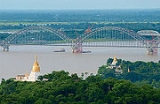
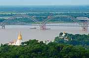
with its famous bell is located near Sagaing but can be reached across the Ayeyarwady from Mandalay
Mandalay
Mandalay is the second-largest city and the last royal capital of Burma. Located north of Yangon on the east bank of the Irrawaddy River, the city has a population of one million, and is the capital of Mandalay Region ....
. The districts are Sagaing
Sagaing District
Sagaing District is an administrative district in southern Sagaing Division, Burma . Its administrative center is the city of Sagaing.-Townships:Tamu District consists of the following townships:...
, Shwebo
Shwebo District
Shwebo District is a district in south-central Sagaing Division of Burma . Its administrative center is the city of Shwebo.The district consists of the townships of Kanbalu, Khin-U, Kyunhla, Shwebo, Taze, Wetlet, and Ye-U....
, Monywa
Monywa District
Monywa District is an administrative district in southern Sagaing Division, Burma . Its administrative center is the city of Monywa.-Townships:Monywa District consists of the following townships:* Ayadaw* Budalin* Chaung-U* Kani* Monywa...
, Katha
Katha District
Katha District is the northeastern-most district in Sagaing Division of Burma . Its administrative center is the town of Katha.The district consists of the townships of Banmauk, Indaw, Katha, Kawlin, Pinlebu, Tigyaing, and Wuntho....
, Kale (Kalemyo)
Kale District
Kale District is the western-most district in Sagaing Division of Burma . Its administrative center is the city of Kalaymyo...
, Tamu
Tamu District
Tamu District or Tuimu District is an administrative district in Sagaing Division, Burma . Its administrative center is the town of Tamu....
, Mawlaik
Mawlaik District
Mawlaik District is a district in central Sagaing Division of Burma . Its administrative center is the town of Mawlaik.The district consists of just two townships, Mawlaik and Paungbyin...
and Hkamti
Hkamti District
Hkamti District or Khamti District is a district in northern Sagaing Division of Burma . Its administrative center is the town of Singkaling Hkamti....
. The townships are:
|
Kale Township Kale Township is a township in Kale District in the Sagaing Division of Burma . The principal town is Kalaymyo.-Geography and borders:... Kalewa Township Kalewa Township is a township of Kale District in Sagaing Division of Burma . The principal town and administrative seat is Kalewa. The Paluzawa coal mines are located in Kalewa township.-Borders:Kalewa Township is bordered by:... Kanbalu Township Kanbalu Township is a township in Shwebo District in the Sagaing Division of Burma.The principal town is Kanbalu.-External links:* - map showing the township boundary... Kani Township Kani Township is a township in Monywa District in the Sagaing Division of Burma. The principal town is Kani.-External links:* - map showing the township boundary... Katha Township Katha Township is a township in Katha District in the Sagaing Region of Burma. The principal town is Katha. The township is served by a branch railway line that leaves the main line just north of Indaw.-External links:... Kawlin Township Kawlin Township is a township in Katha District in the Sagaing Division of Burma. The principal town is Kawlin.-External links:* - map showing the township boundary... Khin-U Township Khin-U Township is a township in Shwebo District in the Sagaing Division of Burma.The principal town is Khin-U.-External links:* - map showing the township boundary... |
Kyunhla Township Kyunhla Township is a township in Shwebo District in the Sagaing Division of Burma.The principal town is Kyunhla.-External links:* - map showing the township boundary... Mawlaik Township Mawlaik Township is a township in Mawlaik District in the Sagaing Division of Burma. The principal town is Mawlaik.-External links:* - map showing the township boundary... Mingin Township Mingin Township is a township of Kale District in Sagaing Division of Burma . The principal town and administrative seat is Mingin .-Borders:Mingin Township is bordered by:* Kalewa Township, to the north,... Monywa Township Monywa Township is a township in Monywa District in the Sagaing Division of Burma. The principal town is Monywa.-External links:* - map showing the township boundary... Myaung Township Myaung Township is a township in Sagaing District in the Sagaing Division of Burma,-External links:* - map showing the township boundary... Myinmu Township Myinmu Township is a township in the southeast of the Sagaing Division in Burma , west of Mandalay. The principal town is Myinmu which lies on the northern bank of the Irrawaddy River... Pale Township Pale Township is a township in Monywa District in the Sagaing Division of Burma. The principal town is Pale.-External links:* - map showing the township boundary... |
Paungbyin Township Paungbyin Township is a township in Mawlaik District in the Sagaing Division of Burma. The principal town is Paungbyin.-External links:* - map showing the township boundary... Pinlebu Township Pinlebu Township is a township in Katha District in the Sagaing Division of Burma. The principal town is Pinlebu.-External links:* - map showing the township boundary... Sagaing Township Sagaing Township is a township in Sagaing District in the Sagaing Division of Burma. The principal town is Sagaing.-External links:* - map showing the township boundary... Salingyi Township Salingyi Township is a township in Monywa District in the Sagaing Division of Burma. The principal town is Salingyi.-External links:* - map showing the township boundary... Shwebo Township Shwebo Township is a township of Shwebo District in the Sagaing Region of Burma .It is located on the plains between the Mu River and the Ayeyarwady River. The ancient palace of King Alaungmintaya is being excavated there... Tabayin Township Tabayin Township is a township in Monywa District in the Sagaing Division of Burma. The principal town is Tabayin.-External links:* - map showing the township boundary... Tamu Township Tamu Township is a township in Tamu District in the Sagaing Division of Burma.The principal town is Tamu. The only township of Tamu District, the township borders India.-External links:* - map showing the township boundary... |
Taze Township Taze Township is a township in Shwebo District in the Sagaing Division of Burma.The principal town is Taze.-External links:* - map showing the township boundary... Tigyaing Township Htigyaing Township or Tigyaing Township is a township of Katha District in eastern Sagaing Division, in northern Burma . It lies on the border with the Shan State of Burma. The administrative seat is at Htigyaing.... Wetlet Township Wetlet Township is a township of Shwebo District in the Sagaing Division of Burma .It is located on the plains between the Mu River and the Irrawaddy. Its administrative seat is the town of Wetlet.... Wuntho Township Wuntho Township is a township in Katha District in the Sagaing Division of Burma. The principal town is Wuntho.Wuntho was a native state of Upper Burma when Burma was under British control... Ye-U Township Ye-U Township is a township in Shwebo District in the Sagaing Division of Burma.The principal town is Ye-U.-External links:* - map showing the township boundary... Yinmabin Township Yinmabin Township is a township in Monywa District in the Sagaing Division of Burma. The principal town is Yinmabin.-External links:* - map showing the township boundary... |
In August 2010, three former townships of Sagaing Region were transferred, in accordance with the 2008 constitution, to a new administrative unit the Naga Self-Administered Zone
Naga Self-Administered Zone
Naga Self-Administered Zone , as stipulated by the 2008 Constitution, is a self-administered zone consisting of three townships, Leshi, Lahe and Namyun townships, formerly administered as pat of Hkamti District, Sagaing Division. Its official name was announced by decree on 20 August 2010. The zone...
which is no longer part of Sagaing Region. Those townships were Lahe
Lahe Township
Lahe Township is a township in the Naga Self-Administered Zone in the Sagaing Division of Burma.The principal town is Lahe.-Towns and villages:...
, Leshi
Leshi Township
Leshi Township , Lashe Township or Lay Shi Township is a mountainous township in the Naga Self-Administered Zone in the Sagaing Division of Burma .The principal town is Leshi...
and Nanyun
Nanyun Township
Nanyun Township is a township in the Naga Self-Administered Zone in the Sagaing Division of Burma.The principal town is Nanyun....
.
Demographics
The Bamar (Burmans) are the majority ethnic groupEthnic group
An ethnic group is a group of people whose members identify with each other, through a common heritage, often consisting of a common language, a common culture and/or an ideology that stresses common ancestry or endogamy...
in the dry regions and along the Mandalay-Myitkyina
Myitkyina
Myitkyina is the capital city of Kachin State in Myanmar , located from Yangon, and from Mandalay. In Burmese it means "near the big river", and in fact "Myitkyina" lies on the west bank of the Ayeyarwady River, just below from Myit-son of its two headstreams...
Railroad. Shan live in the upper Chindwin River
Chindwin River
The Chindwin River is a river in Burma , and the largest tributary of the country's chief river the Ayeyarwady . It flows entirely within Burma and is known as Ning-thi to the Manipuris.-Source:...
valley. A sizable minority of Naga
Naga people
The term Naga people refers to a conglomeration of several tribes inhabiting the North Eastern part of India and north-western Burma. The tribes have similar cultures and traditions, and form the majority ethnic group in the Indian state of Nagaland...
resides in the north of north-west mountain ranges and Chin
Chin people
The Chin , known as the Kuki in Assam, are one of the ethnic groups in Burma. The Chins are found mainly in western part of Burma and numbered circa 1.5 million. They also live in nearby Indian states of Nagaland, Mizoram and Manipur and Assam. Owing to Mizo influence and Baptist missionaries'...
in the south. Smaller ethnic groups native to the Region include the Kadu and Ganang, who live in the upper Mu River valley and Meza River valley.
Ecology
There are a number of protected areas in Sagaing Region, among them are Alaungdaw Kathapa National ParkAlaungdaw Kathapa
The Alaungdaw Kathapa National Park, with an area of 1,605 square kilometers, is the largest national park in Burma . The park consists of the Patolon Reserved Forest and the adjoining Taungdwin Reserved Forest.- History :...
, Chatthin Wildlife Sanctuary
Chatthin Wildlife Sanctuary
Chatthin Wildlife Sanctuary is a wildlife reserve of Burma. It is located in Kanbalu Township in Sagaing Division. It occupies an area of and was established in 1941.-References:*...
, Mahamyaing Wildlife Sanctuary, and Htamanthi Wildlife Sanctuary
Tamanthi Wildlife Reserve
Tamanthi Wildlife Reserve is a wildlife reserve of Burma . It was established on April 11, 1974 on the eastern bank of the Chindwin River, across from the town of Tamanthi...
in Homalin Township
Homalin Township
Homalin Township is a township in Hkamti District in the Sagaing Division of Burma. The principal town is Homalin. The principal rivers flowing through the township are the Chindwin River form north to south and the Uyu River from east to west, joining the Chindwin near Homalin...
.
Transport
Ayeyarwady River
The Irrawaddy River or Ayeyarwady River is a river that flows from north to south through Burma . It is the country's largest river and most important commercial waterway. Originating from the confluence of the N'mai and Mali rivers, it flows relatively straight North-South before emptying through...
and the Chindwin
Chindwin River
The Chindwin River is a river in Burma , and the largest tributary of the country's chief river the Ayeyarwady . It flows entirely within Burma and is known as Ning-thi to the Manipuris.-Source:...
, river transport is a common way to move people and cargo. Much of the inland Sagaing Region relies on roads and rail in poor condition.
Economy
Agriculture is the chief occupation. The leading crop is riceRice
Rice is the seed of the monocot plants Oryza sativa or Oryza glaberrima . As a cereal grain, it is the most important staple food for a large part of the world's human population, especially in East Asia, Southeast Asia, South Asia, the Middle East, and the West Indies...
, which occupies most of the arable ground. Other crops include wheat
Wheat
Wheat is a cereal grain, originally from the Levant region of the Near East, but now cultivated worldwide. In 2007 world production of wheat was 607 million tons, making it the third most-produced cereal after maize and rice...
, sesame
Sesame
Sesame is a flowering plant in the genus Sesamum. Numerous wild relatives occur in Africa and a smaller number in India. It is widely naturalized in tropical regions around the world and is cultivated for its edible seeds, which grow in pods....
, peanut
Peanut
The peanut, or groundnut , is a species in the legume or "bean" family , so it is not a nut. The peanut was probably first cultivated in the valleys of Peru. It is an annual herbaceous plant growing tall...
, pulses, cotton
Cotton
Cotton is a soft, fluffy staple fiber that grows in a boll, or protective capsule, around the seeds of cotton plants of the genus Gossypium. The fiber is almost pure cellulose. The botanical purpose of cotton fiber is to aid in seed dispersal....
, and tobacco
Tobacco
Tobacco is an agricultural product processed from the leaves of plants in the genus Nicotiana. It can be consumed, used as a pesticide and, in the form of nicotine tartrate, used in some medicines...
. Sagaing is Myanmar’s leading producer of wheat, contributing more than 80% of the country's total production. Forestry is important in the wetter upper regions along the Chindwin River
Chindwin River
The Chindwin River is a river in Burma , and the largest tributary of the country's chief river the Ayeyarwady . It flows entirely within Burma and is known as Ning-thi to the Manipuris.-Source:...
, with teak
Teak
Teak is the common name for the tropical hardwood tree species Tectona grandis and its wood products. Tectona grandis is native to south and southeast Asia, mainly India, Indonesia, Malaysia, and Burma, but is naturalized and cultivated in many countries, including those in Africa and the...
and other hardwoods extracted. As in other parts of the country, reforestation
Reforestation
Reforestation is the natural or intentional restocking of existing forests and woodlands that have been depleted, usually through deforestation....
is not effective enough to maintain sustainable forestry. Important minerals include gold
Gold
Gold is a chemical element with the symbol Au and an atomic number of 79. Gold is a dense, soft, shiny, malleable and ductile metal. Pure gold has a bright yellow color and luster traditionally considered attractive, which it maintains without oxidizing in air or water. Chemically, gold is a...
, coal
Coal
Coal is a combustible black or brownish-black sedimentary rock usually occurring in rock strata in layers or veins called coal beds or coal seams. The harder forms, such as anthracite coal, can be regarded as metamorphic rock because of later exposure to elevated temperature and pressure...
, salt
Salt
In chemistry, salts are ionic compounds that result from the neutralization reaction of an acid and a base. They are composed of cations and anions so that the product is electrically neutral...
and small amounts of petroleum
Petroleum
Petroleum or crude oil is a naturally occurring, flammable liquid consisting of a complex mixture of hydrocarbons of various molecular weights and other liquid organic compounds, that are found in geologic formations beneath the Earth's surface. Petroleum is recovered mostly through oil drilling...
. Industry includes textiles, copper
Copper
Copper is a chemical element with the symbol Cu and atomic number 29. It is a ductile metal with very high thermal and electrical conductivity. Pure copper is soft and malleable; an exposed surface has a reddish-orange tarnish...
refining, gold smelting, and a diesel engine
Diesel engine
A diesel engine is an internal combustion engine that uses the heat of compression to initiate ignition to burn the fuel, which is injected into the combustion chamber...
plant. The Region has many rice mills, edible oil mills, saw mills, cotton mills, and mechanized weaving factories. Local industry includes earthen pots, silverware, bronze-wares, iron-wares and lacquerware
Lacquerware
Lacquerware are objects decoratively covered with lacquer. The lacquer is sometimes inlaid or carved. Lacquerware includes boxes, tableware, buttons and even coffins painted with lacquer in cultures mostly in the Eastern Hemisphere.-History:...
.
Education
Educational opportunities in Myanmar are extremely limited outside the main cities of YangonYangon
Yangon is a former capital of Burma and the capital of Yangon Region . Although the military government has officially relocated the capital to Naypyidaw since March 2006, Yangon, with a population of over four million, continues to be the country's largest city and the most important commercial...
and Mandalay
Mandalay
Mandalay is the second-largest city and the last royal capital of Burma. Located north of Yangon on the east bank of the Irrawaddy River, the city has a population of one million, and is the capital of Mandalay Region ....
. According to official statistics, less than 10% of primary school students in Sagaing Region reach high school.
| AY 2002-2003 | Primary | Middle | High |
|---|---|---|---|
| Schools | 3854 | 190 | 84 |
| Teachers | 16,100 | 5000 | 1600 |
| Students | 550,000 | 140,000 | 49,000 |
Sagaing Region has two national "professional" universities in the Monywa Institute of Economics
Monywa Institute of Economics
The Monywa Institute of Economics , located in Monywa, Sagaing Region, is one of three universities of economics and business in Myanmar. The institute offers undergraduate and graduate degrees and diplomas, mostly in commerce, statistics and economics...
and the Sagaing Institute of Education
Sagaing Institute of Education
The Sagaing Institute of Education , located in Sagaing, Sagaing Division, is one of two senior universities of education in Myanmar. Primarily a teacher training college, the institute offers Bachelor of Education degree programs in education to the country's prospective primary, secondary and...
. Monywa University is the main liberal arts
Liberal arts
The term liberal arts refers to those subjects which in classical antiquity were considered essential for a free citizen to study. Grammar, Rhetoric and Logic were the core liberal arts. In medieval times these subjects were extended to include mathematics, geometry, music and astronomy...
university in the region.
Health care
The general state of health care in Myanmar is poor. The military government spends anywhere from 0.5% to 3% of the country's GDP on health care, consistently ranking among the lowest in the world. Although health care is nominally free, in reality, patients have to pay for medicine and treatment, even in public clinics and hospitals. Public hospitals lack many of the basic facilities and equipment. Moreover, the health care infrastructure outside of YangonYangon
Yangon is a former capital of Burma and the capital of Yangon Region . Although the military government has officially relocated the capital to Naypyidaw since March 2006, Yangon, with a population of over four million, continues to be the country's largest city and the most important commercial...
and Mandalay
Mandalay
Mandalay is the second-largest city and the last royal capital of Burma. Located north of Yangon on the east bank of the Irrawaddy River, the city has a population of one million, and is the capital of Mandalay Region ....
is extremely poor. In 2003, Sagaing Region had less than a quarter of hospital beds than Yangon Region with a similar size of population.
| 2002–2003 | # Hospitals | # Beds |
|---|---|---|
| Specialist hospitals | 0 | 0 |
| General hospitals with specialist services | 2 | 400 |
| General hospitals | 38 | 1168 |
| Health clinics | 48 | 768 |
| Total | 88 | 2336 |