
Administrative divisions of Myanmar
Encyclopedia
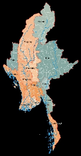
Burma is divided into twenty-one administrative subdivisions, which include
The regions were called divisions prior to August 2010, and five of them are named after their capital city, the exceptions being Ayeyarwady Region and Tanintharyi Region. The regions can be described as ethnically predominantly Burman (Bamar)
, while the states, the zones and Wa Division are ethnic minority-dominant.
Mandalay Region has the largest population and Yangon Region is the most densely populated. The smallest population is Kayah State
. In terms of land area, Shan State
is the largest and Yangon Region is the smallest.
States and divisions are divided into districts
. These districts consist of townships
that include towns , wards ) and village-tracts . Village-tracts are groups of adjacent villages .
. Day-to-day functions would be carried out on the President's behalf by the Naypyidaw Council led by a Chairperson. The Chairperson and members of the Naypyidaw Council are appointed by the President and shall include civilians and representatives of the Armed Forces.
Within the Sagain Region
Within the Shan State
, whose capital was Rangoon, and Upper Burma
, whose capital was Mandalay. Within Lower Burma were four divisions (Arakan, Irrawaddy, Pegu, Tenasserim). Upper Burma had 6 divisions (Meiktila
, Minbu, Sagaing, North Federated Shan States and South Federated Shan States).
In 10 October 1922, the Karenni States of Bawlake, Kantarawaddy, and Kyebogyi became a part of the Federated Shan States. In 1940, Minbu division's name was changed to Magwe, and Meiktila Divisions became part of Mandalay District.
In 1952, Karenni State was renamed Kayah State. In 1964, Rangoon Division was separated from Pegu Division, whose capital shifted to Pegu. In addition, Karen State was renamed Kawthule State.
In 1972, the Hanthawaddy and Hmawbi districts were moved under Rangoon Division's juridstiction.
In 1974, after Ne Win
introduced a constitution, Chin Division became a state, and its capital moved from Falam
to Hakha
. Kawthule State's name was reverted to Karen State, and Mon State was separated from Tenasserim Division. Mon State's capital became Moulmein, and Tenasserim Division's became Tavoy
. In addition, Rakhine Division was granted statehood.
In 1989, after the coup d'état by the military junta
, the names of many divisions in Burma were altered in English to reflect Burmese
pronunciations.
After 1995, in Kachin State Mohnyin District
was created out of Myitkyina District
as part of the peace agreement with the Kachin Independence Army
.
and ethnic self-administered zones ( in Burmese) and self-administered divisions ( in Burmese). These self-administered regions include the following:
On 20 August 2010, the renaming of the 7 divisions and the naming of the 6 self-administered zones was announced by Burmese state media.
- seven states ,
- seven regions ,
- five self-administered zones and
- one self-administered division .
The regions were called divisions prior to August 2010, and five of them are named after their capital city, the exceptions being Ayeyarwady Region and Tanintharyi Region. The regions can be described as ethnically predominantly Burman (Bamar)
Bamar
The Bamar are the dominant ethnic group of Burma , constituting approximately two-thirds of the population. The Bamar live primarily in the Irrawaddy basin, and speak the Burmese language, which is also the official language of Burma. Bamar customs and identity are closely intertwined with general...
, while the states, the zones and Wa Division are ethnic minority-dominant.
Mandalay Region has the largest population and Yangon Region is the most densely populated. The smallest population is Kayah State
Kayah State
Kayah State is a state of Myanmar. Situated in eastern Myanmar, it is bounded on the north by Shan State, on the east by Thailand's Mae Hong Son Province, and on the south and west by Kayin State. It lies approximately between 18° 30' and 19° 55' north latitude and between 94°40' and 97° 93' east...
. In terms of land area, Shan State
Shan State
Shan State is a state of Burma . Shan State borders China to the north, Laos to the east, and Thailand to the south, and five administrative divisions of Burma in the west. Largest of the 14 administrative divisions by land area, Shan State covers 155,800 km², almost a quarter of the total...
is the largest and Yangon Region is the smallest.
States and divisions are divided into districts
Districts of Burma
Burma's states and regions are divided into 67 districts , which in turn are subdivided into townships then towns, wards and villages.-Kachin State:*Bhamo District*Mohnyin District*Myitkyina District*Putao District-Kayin State:*Hpa-an District...
. These districts consist of townships
Townships of Burma
Townships are the third-level administrative divisions of Burma. They are the sub divisions of the Districts of Burma. According to the Myanmar Information Management Unit , as of December 2007, there are 325 townships of Burma...
that include towns , wards ) and village-tracts . Village-tracts are groups of adjacent villages .
States, Regions and Union Territories
| Name | Burmese Burmese language The Burmese language is the official language of Burma. Although the constitution officially recognizes it as the Myanmar language, most English speakers continue to refer to the language as Burmese. Burmese is the native language of the Bamar and related sub-ethnic groups of the Bamar, as well as... | Flag Flags of the Burmese states and regions The flags of the Burmese states and regions exhibit a variety of regional influences and local histories, as well as different styles and design principles. Modern state flags date from the 1940s when Burma was starting to gain its independence from the colonial British Empire... |
ISO ISO 3166-2:MM ISO 3166-2:MM is the entry for Myanmar in ISO 3166-2, part of the ISO 3166 standard published by the International Organization for Standardization , which defines codes for the names of the principal subdivisions of all countries coded in ISO 3166-1.Currently for Myanmar, ISO 3166-2 codes are... |
Region | Population | Area (km²) | Type | |
|---|---|---|---|---|---|---|---|---|
| Ayeyarwady Region | Pathein Pathein Pathein , also called Bassein, is a port city with a 2004 population estimated at 215,600, and the capital of the Ayeyarwady Region, Burma. It lies on the Pathein River , which is a western branch of the Irrawaddy River.... |
MM-07 | Lower | 6,663,000 | 35,138 | Region | ||
| Bago Region | Bago | MM-02 | Lower | 5,099,000 | 39,404 | Region | ||
| Chin State Chin State Chin State is a state located in western Burma . The Chin State is bordered by Rakhine State in the south, Bangladesh in south-west, Sagaing Division and Magway Division in the east, Indian state of Manipur in the north and Indian state of Mizoram in the west. The Chin ethnic group make up the... |
Hakha Hakha Hakha is the capital of Chin State in Burma. Its located in the northeast in Chin State. The vernacular name of the city was Halkha. The total area of Hakha is about . The town of Hakha, more than 6,000 feet above the sea level, is founded on a small highland plateau... |
MM-14 | Western | 480,000 | 36,019 | State | ||
| Kachin State Kachin State Kachin State , is the northernmost state of Burma. It is bordered by China to the north and east; Shan State to the south; and Sagaing Division and India to the west. It lies between north latitude 23° 27' and 28° 25' longitude 96° 0' and 98° 44'. The area of Kachin State is . The capital of the... |
Myitkyina Myitkyina Myitkyina is the capital city of Kachin State in Myanmar , located from Yangon, and from Mandalay. In Burmese it means "near the big river", and in fact "Myitkyina" lies on the west bank of the Ayeyarwady River, just below from Myit-son of its two headstreams... |
MM-11 | Northern | 1,270,000 | 89,041 | State | ||
| Kayah State Kayah State Kayah State is a state of Myanmar. Situated in eastern Myanmar, it is bounded on the north by Shan State, on the east by Thailand's Mae Hong Son Province, and on the south and west by Kayin State. It lies approximately between 18° 30' and 19° 55' north latitude and between 94°40' and 97° 93' east... |
Loikaw Loikaw Loikaw is the capital of Kayah State in Burma . It is located near the State's northern tip, just above an embayment on the Pilu River. The inhabitants are mostly Kayah... |
MM-12 | Southeast | 259,000 | 11,670 | State | ||
| Kayin State Kayin State Kayin State is a state of Burma . The capital city is Hpa-an.-History:The region that forms today's Kayin State was part of successive Burmese kingdoms since the formation of the Pagan Empire in mid-11th century... |
Pa-an | MM-13 | South | 1,431,377 | 30,383 | State | ||
| Magway Region | Magwe Magwe -Burma:*Magway, Burma, the capital city of Magway Division of Burma *Magway Division *Magway District in Magway Division*Magway Township in Magway District*Magway University in Magwe, Burma... |
MM-03 | Central | 4,464,000 | 44,819 | Region | ||
| Mandalay Region | Mandalay Mandalay Mandalay is the second-largest city and the last royal capital of Burma. Located north of Yangon on the east bank of the Irrawaddy River, the city has a population of one million, and is the capital of Mandalay Region .... |
MM-04 | Central | 7,627,000 | 37,021.29 | Region | ||
| Mon State Mon State Mon State is an administrative division of Myanmar. It is sandwiched between Kayin State on the east, the Andaman Sea on the west, Bago Region on the north and Tanintharyi Region on the south, and has a short border with Thailand's Kanchanaburi Province at its south-eastern tip. The land area is... |
Mawlamyaing | MM-15 | South | 2,466,000 | 12,155 | State | ||
| Rakhine State Rakhine State Rakhine State is a Burmese state. Situated on the western coast, it is bordered by Chin State in the north, Magway Region, Bago Region and Ayeyarwady Region in the east, the Bay of Bengal to the west, and the Chittagong Division of Bangladesh to the northwest. It is located approximately between... |
Sittwe Sittwe -Economy:In February 2007, India announced a plan to develop the port, which would enable ocean access from Indian Northeastern states, so called "Seven sisters", like Mizoram, via the Kaladan River.... |
 |
MM-16 | West | 2,744,000 | 36,780 | State | |
| Shan State Shan State Shan State is a state of Burma . Shan State borders China to the north, Laos to the east, and Thailand to the south, and five administrative divisions of Burma in the west. Largest of the 14 administrative divisions by land area, Shan State covers 155,800 km², almost a quarter of the total... |
Taunggyi Taunggyi -Transportation:The main access to Taunggyi is by road. A railway line that passes through Taunggyi was recently built in 1995, but at the moment it offers no passenger service. Regular railway passenger service to the rest of the country is through the town of Shwenyaung, twelve miles to the... |
 |
MM-17 | East | 4,851,000 | 155,801 | State | |
| Sagaing Region | Sagaing Sagaing Sagaing is the capital of Sagaing Region in Myanmar. Located on the Ayeyarwady River, 20 km to the southwest of Mandalay on the opposite bank of the river, Sagaing with numerous Buddhist monasteries is an important religious and monastic center. The pagodas and monasteries crowd the numerous... |
MM-01 | Northern | 5,300,000 | 93,527 | Region | ||
| Tanintharyi Region | Dawei Dawei -Transport:Only recently Dawei was connected to the rest of Myanmar by road and rail. There are plans to construct a deepwater port in Dawei. In November 2010, the Myanmar Port Authority signed a USD $8.6 billion deal with Italian-Thai Development to develop a deep sea port at Dawei... |
MM-05 | South | 1,356,000 | 43,328 | Region | ||
| Yangon Region | Yangon Yangon Yangon is a former capital of Burma and the capital of Yangon Region . Although the military government has officially relocated the capital to Naypyidaw since March 2006, Yangon, with a population of over four million, continues to be the country's largest city and the most important commercial... |
MM-06 | Lower | 5,560,000 | 10,170 | Region | ||
| Naypyidaw Union Territory Naypyidaw Union Territory Naypyidaw Union Territory is a administrative division in central Burma . The Union Territory encompasses the administrative capital of Burma, Naypyidaw.-Townships:The Naypyidaw Union Territory consists of the following townships:... |
Naypyidaw Naypyidaw Naypyidaw is the capital city of Burma, also known as Myanmar. It is administered as the Naypyidaw Union Territory, as per the 2008 Constitution. On 6 November 2005, the administrative capital of Myanmar was officially moved to a greenfield 3.2 km west of Pyinmana, and approximately... |
Central | 925,000 | Union Territory |
Self-Administered Zones and Self-Administered Divisions
| Name | Burmese Burmese language The Burmese language is the official language of Burma. Although the constitution officially recognizes it as the Myanmar language, most English speakers continue to refer to the language as Burmese. Burmese is the native language of the Bamar and related sub-ethnic groups of the Bamar, as well as... | |Region | Population | Area (km²) | Type | |
|---|---|---|---|---|---|---|
| Danu Self-Administered Zone Danu Self-Administered Zone Danu Self-Administered Zone , as stipulated by the 2008 Constitution, is a self-administered zone consisting of 2 townships in Shan State: Ywangan and Pindaya Townships. Its official name was announced by decree on 20 August 2010. The zone is to be self-administered by the Danu people.-References:... |
Pindaya Pindaya Pindaya is a town in the Shan State of Burma. It is located in the west of the state in Pindaya Township in Taunggyi District. Mainly famous for its limestone caves called Pindaya Caves where thousands of Buddha images have been consecrated for worship over the centuries, it is also one of the... |
East | Self-Administered Zone | |||
| Kokang Self-Administered Zone Kokang Self-Administered Zone Kokang Self-Administered Zone , as stipulated by the 2008 Constitution, consists of Konkyan and Laukkai in Shan State. Its official name was announced by decree on 20 August 2010.-References:... |
Laukkai Laukkai Laukkai is the capital of Kokang in the northern part of Shan State, Burma. It is situated on the Salween River, which forms Burma's border with the People's Republic of China. It is about 10 miles away from Nansan , China... |
East | Self-Administered Zone | |||
| Naga Self-Administered Zone Naga Self-Administered Zone Naga Self-Administered Zone , as stipulated by the 2008 Constitution, is a self-administered zone consisting of three townships, Leshi, Lahe and Namyun townships, formerly administered as pat of Hkamti District, Sagaing Division. Its official name was announced by decree on 20 August 2010. The zone... |
Lahe | Northern | Self-Administered Zone | |||
| Pa-O Self-Administered Zone Pa-O Self-Administered Zone Pa-O Self-Administered Zone , as stipulated by the 2008 Constitution, consists of Hopong, Hsihseng and Pinlaung Townships in Shan State. Its official name was announced by decree on 20 August 2010. The zone is to be self-administered by the Pa-O people.... |
Hopong Hopong Hopong is a town in the Shan State of eastern Burma. It is located in Hopong Township in Taunggyi District.-External links:*... |
East | Self-Administered Zone | |||
| Pa Laung Self-Administered Zone Pa Laung Self-Administered Zone Palaung Self-Administered Zone , is an autonomous zone in Burma , consisting of Namhsan Township and Mantong Township in Shan State. It was created as a separately administered unit by the 2008 Constitution. Its official name was announced by decree on 20 August 2010. The zone is to be... |
Namhsan | East | Self-Administered Zone | |||
| Wa Self-Administered Division Wa Self-Administered Division Wa Self-Administered Division , as stipulated by the 2008 Constitution, consists of Hopang, Mongmao, Pangwaun , Namphan , Matman and Pangsang townships in Shan State. Its official name was announced by decree on 20 August 2010... |
Hopang Hopang Hopang is the principal town of Hopang Township of Shan State. Its coordination is 23 25' 00" N and 98 46' 00" E.... |
East | Self-Administered Division |
System of administration
The administrative structure of the states, regions and self administering bodies is outlined in the new constitution adopted in 2008.States and regions
Each state or region has a Regional Government or a State Government consisting of a Chief Minister, other Ministers and an Adovocate General. Legislative authority would reside with the State Hluttaw or Regional Hluttaw made up of elected civilian members and representatives of the Armed Forces.Naypyidaw Union Territory
The constitution states that Naypyidaw shall be a Union Territory under the direct administration of the PresidentPresident of Burma
The President of Burma is the head of state and head of government of the Republic of the Union of Myanmar, and leads the executive branch of the Burmese government, and heads the Cabinet of Burma. The president is elected by members of parliament, not by the general population. The Presidential...
. Day-to-day functions would be carried out on the President's behalf by the Naypyidaw Council led by a Chairperson. The Chairperson and members of the Naypyidaw Council are appointed by the President and shall include civilians and representatives of the Armed Forces.
Self-Administered Zones and Self-Administered Divisions
Self-Administered Zones and Self-Administered Divisions are administered by a Leading Body. The Leading Body consists of at least ten members and includes State or Regional Hlutttaw members elected from the Zones or Divisions and other members nominated by the Armed Forces. The Leading Body has both executive and legislative powers. A Chairperson is head of each Leading Body.Within the Sagain Region
- Naga (Leshi, Lahe and Namyun townships)
Within the Shan State
- Palaung (Namshan and Manton townships)
- Kokang (Konkyan and Laukkai townships)
- Pao (Hopong, Hshihseng and Pinlaung townships),
- Danu (Ywangan and Pindaya townships),
- Wa Selfadministrated division (Hopang, Mongmao, Panwai, Pangsang, Naphan and Metman townships)
British colonisation
In 1900, Burma was a province of British India, and was divided into two subdivisions: Lower BurmaLower Burma
Lower Burma is a geographic region of Burma and includes the low-lying Irrawaddy delta , as well as coastal regions of the country ....
, whose capital was Rangoon, and Upper Burma
Upper Burma
Upper Burma refers to a geographic region of Burma , traditionally encompassing Mandalay and its periphery , or more broadly speaking, Kachin and Shan States....
, whose capital was Mandalay. Within Lower Burma were four divisions (Arakan, Irrawaddy, Pegu, Tenasserim). Upper Burma had 6 divisions (Meiktila
Meiktila
Meiktila is a city in central Myanmar, located on the banks of Lake Meiktila in Mandalay Division, at the junctions of the Bagan-Taunggyi, Yangon-Mandalay and Meiktila-Myingyan highways. Because of its strategic position, Meiktila is home to Myanmar Air Force's central command and Meiktila Air...
, Minbu, Sagaing, North Federated Shan States and South Federated Shan States).
In 10 October 1922, the Karenni States of Bawlake, Kantarawaddy, and Kyebogyi became a part of the Federated Shan States. In 1940, Minbu division's name was changed to Magwe, and Meiktila Divisions became part of Mandalay District.
Post-independence
Upon independence, in 4 January 1948, the Chin Hills area was split from Arakan Division to form Chin State (Zogam), and Kachin State was formed by carving out the Myitkyina and Bhamo districts of Mandalay Division. Karen State was also created from Amherst, Thaton, and Toungoo Districts of Tenasserim Division. Karenni State was separated from the Federated Shan States, and Shan State was formed by merging the Federated Shan States and the Wa States.In 1952, Karenni State was renamed Kayah State. In 1964, Rangoon Division was separated from Pegu Division, whose capital shifted to Pegu. In addition, Karen State was renamed Kawthule State.
In 1972, the Hanthawaddy and Hmawbi districts were moved under Rangoon Division's juridstiction.
In 1974, after Ne Win
Ne Win
Ne Win was Burmese a politician and military commander. He was Prime Minister of Burma from 1958 to 1960 and 1962 to 1974 and also head of state from 1962 to 1981...
introduced a constitution, Chin Division became a state, and its capital moved from Falam
Falam (town)
Falam is a town in north-western Burma near Burma's western border with the Indian state of Mizoram. The town was originally founded by the British in 1892, and became an important place for the British government to rule the whole Chin Hills at that time...
to Hakha
Hakha
Hakha is the capital of Chin State in Burma. Its located in the northeast in Chin State. The vernacular name of the city was Halkha. The total area of Hakha is about . The town of Hakha, more than 6,000 feet above the sea level, is founded on a small highland plateau...
. Kawthule State's name was reverted to Karen State, and Mon State was separated from Tenasserim Division. Mon State's capital became Moulmein, and Tenasserim Division's became Tavoy
Dawei
-Transport:Only recently Dawei was connected to the rest of Myanmar by road and rail. There are plans to construct a deepwater port in Dawei. In November 2010, the Myanmar Port Authority signed a USD $8.6 billion deal with Italian-Thai Development to develop a deep sea port at Dawei...
. In addition, Rakhine Division was granted statehood.
In 1989, after the coup d'état by the military junta
Military junta
A junta or military junta is a government led by a committee of military leaders. The term derives from the Spanish language junta meaning committee, specifically a board of directors...
, the names of many divisions in Burma were altered in English to reflect Burmese
Burmese language
The Burmese language is the official language of Burma. Although the constitution officially recognizes it as the Myanmar language, most English speakers continue to refer to the language as Burmese. Burmese is the native language of the Bamar and related sub-ethnic groups of the Bamar, as well as...
pronunciations.
After 1995, in Kachin State Mohnyin District
Mohnyin District
Mohnyin District is a district of the Kachin State in northern Burma . The administrative center is Mohnyin.-Townships:The district contains the following three townships:*Mongyaung Township*Mohnyin Township*Hpakant Township...
was created out of Myitkyina District
Myitkyina District
Myitkyina District is a district of the Kachin State in northern Burma . The capital lies at Myitkyina.-Townships:The district contains the following townships:*Myitkyina Township*Waingmaw Township*Injangyang Township*Tanai Township...
as part of the peace agreement with the Kachin Independence Army
Kachin Independence Army
The Kachin Independence Army is the military arm of the Kachin Independence Organization , a political group composed of ethnic Kachins in northern Burma...
.
2008 Constitution
The 2008 Constitution stipulates the renaming of the 7 "divisions" ( in Burmese) as "regions" ( in Burmese). It also stipulates the creation of Union territories, which include the capital of NaypyidawNaypyidaw
Naypyidaw is the capital city of Burma, also known as Myanmar. It is administered as the Naypyidaw Union Territory, as per the 2008 Constitution. On 6 November 2005, the administrative capital of Myanmar was officially moved to a greenfield 3.2 km west of Pyinmana, and approximately...
and ethnic self-administered zones ( in Burmese) and self-administered divisions ( in Burmese). These self-administered regions include the following:
- Naga Self-Administered ZoneNaga Self-Administered ZoneNaga Self-Administered Zone , as stipulated by the 2008 Constitution, is a self-administered zone consisting of three townships, Leshi, Lahe and Namyun townships, formerly administered as pat of Hkamti District, Sagaing Division. Its official name was announced by decree on 20 August 2010. The zone...
: consisting of LeshiLeshiLeshi , is a town in Naga Hills of Sagaing Division on the northwest frontier of Burma. According to the new 2008 Constitution of the military regime, it will now be grouped together with Lahe and Nanyun in Naga Self-Administered Zone...
, Lahe and NamyunNanyun-External links:*[ Satellite map at Maplandia.com]...
Townships in Sagaing Division - Danu Self-Administered ZoneDanu Self-Administered ZoneDanu Self-Administered Zone , as stipulated by the 2008 Constitution, is a self-administered zone consisting of 2 townships in Shan State: Ywangan and Pindaya Townships. Its official name was announced by decree on 20 August 2010. The zone is to be self-administered by the Danu people.-References:...
: consisting of YwanganYwangan TownshipYwangan Township is a township of Taunggyi District in the Shan State of Myanmar. The principal town is Ywangan....
and Pindaya TownshipPindaya TownshipPindaya Township is a township of Taunggyi District in the Shan State of Myanmar. The principal town is Pindaya....
s in Shan State - Pa-O Self-Administered ZonePa-O Self-Administered ZonePa-O Self-Administered Zone , as stipulated by the 2008 Constitution, consists of Hopong, Hsihseng and Pinlaung Townships in Shan State. Its official name was announced by decree on 20 August 2010. The zone is to be self-administered by the Pa-O people....
: consisting of HopongHopong TownshipHopong Township is a township of Taunggyi District in the Shan State of Myanmar. The principal town is Hopong....
, HsihsengHsi Hseng TownshipHsi Hseng Township is a township of Taunggyi District in the Shan State of Myanmar. The principal town is Hsi Hseng.-Towns and villages:Bàn Tet Paw Thwe Chitiwabwa Dawhsaw-hswi Dawlaw-hku Dawta-naw Hang Loi Hko-hpon Hkolai Hko-law Hku-weng Ho-hkai Ho-hko Ho-hpai Hokan Honawng Ho-ti Hpailon Hpaimūn...
and Pinlaung TownshipPinlaung TownshipPinlaung Township is a township of Taunggyi District in the Shan State of Myanmar. The principal town is Pinlaung....
s in Shan State - Pa Laung Self-Administered ZonePa Laung Self-Administered ZonePalaung Self-Administered Zone , is an autonomous zone in Burma , consisting of Namhsan Township and Mantong Township in Shan State. It was created as a separately administered unit by the 2008 Constitution. Its official name was announced by decree on 20 August 2010. The zone is to be...
: consisting of NamhsanNamhsan TownshipNamhsan Township is a township of Kyaukme District in the Shan State of eastern Burma. The principal town is Namhsan....
and Manton TownshipMantong TownshipMantong Township is a township of the Pa Laung Self-Administered Zone in the Shan State of Burma . The principal town and administrative seat is Mantong ....
s in Shan State - Kokang Self-Administered ZoneKokang Self-Administered ZoneKokang Self-Administered Zone , as stipulated by the 2008 Constitution, consists of Konkyan and Laukkai in Shan State. Its official name was announced by decree on 20 August 2010.-References:...
: consisting of Konkyan and Laukkai TownshipLaukkaing TownshipLaukkaing Township is a township of Laukkaing District in the Shan State of Burma. The principal town is Laukkai aka Laukkaing.The township is sharing border with Kongyan Township and People's Republic of China in the north, People's Republic of China in the east, Kunlong Township in the south and...
s in Shan State - Wa Self-Administered DivisionWa Self-Administered DivisionWa Self-Administered Division , as stipulated by the 2008 Constitution, consists of Hopang, Mongmao, Pangwaun , Namphan , Matman and Pangsang townships in Shan State. Its official name was announced by decree on 20 August 2010...
: consisting of HopangHopang TownshipHopang Township is a township of Kunlong District in the Shan State of Burma. The principal town is Hopang. It is one of the 6 townships of Wa Self-Administered Division...
, Mongma, Panwai, Nahpan, Metman and Pangsang (Pankham) townships in Shan State
On 20 August 2010, the renaming of the 7 divisions and the naming of the 6 self-administered zones was announced by Burmese state media.
See also
- Districts of BurmaDistricts of BurmaBurma's states and regions are divided into 67 districts , which in turn are subdivided into townships then towns, wards and villages.-Kachin State:*Bhamo District*Mohnyin District*Myitkyina District*Putao District-Kayin State:*Hpa-an District...
- List of cities in Burma
- Flags of the Burmese states and regionsFlags of the Burmese states and regionsThe flags of the Burmese states and regions exhibit a variety of regional influences and local histories, as well as different styles and design principles. Modern state flags date from the 1940s when Burma was starting to gain its independence from the colonial British Empire...
- ISO 3166-2:MMISO 3166-2:MMISO 3166-2:MM is the entry for Myanmar in ISO 3166-2, part of the ISO 3166 standard published by the International Organization for Standardization , which defines codes for the names of the principal subdivisions of all countries coded in ISO 3166-1.Currently for Myanmar, ISO 3166-2 codes are...