
Chindwin River
Encyclopedia
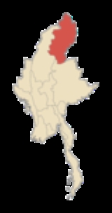
The Chindwin River is a river in Burma (Myanmar), and the largest tributary
of the country's chief river the Ayeyarwady
(Irrawaddy). It flows entirely within Burma and is known as Ning-thi to the Manipuris
.
of Kachin State
of Burma, roughly
26°26′18"N 96°33′32"E, where the Tanai, the Tabye, the Tawan, and the Taron (also known as Turong or Towang) rivers meet.
The headwaters of the Tanai are at about
25°30′N 97°0′E on the Shwedaunggyi peak of the Kumon range, 12 miles north of Mogaung
. It flows due north for the first part until it reaches the Hukawng Valley. In 2004, the government established the world's largest tiger preserve in the Hukawng Valley, the Hukawng Valley Wildlife Sanctuary
, with an area of approximately 2500 square miles (6,475 km²); later, the Sanctuary was extended to 21,800 sq.km, making it the largest protected area in mainland Southeast Asia. The river then turns to the west and flows through the middle of the plain , joined by the Tabye, the Tawan, and the Taron rivers from the right bank. These rivers drain the mountain ranges to the north and northeast of the Hukawng valley.
in the river. It then takes on the name of Chindwin, and maintains a general southerly course. It passes the town of Singkaling Hkamti on the left bank, then the town of Homalin
, also on the left bank.
The river's course is generally southwesterly until the town of Mingin
. It then takes a more southeasterly course entering into broad central plain, passing the city of Monywa
on the left bank. Its course at this point forms the boundary between the Sagaing District
of Sagaing Region and the Pakokku District
of Magway Region.
It enters the Ayeyarwady River (Irrawaddy)
at about 21°30′N 95°15′E. The extreme outlets into the Ayeyarwady are about 22 miles apart, the interval forming a succession of long, low, partially populated islands. The lowest mouth
of the Chindwin is, according to tradition, an artificial channel, cut by one of the kings of Bagan
(Pagan). It was choked up for centuries until 1824 when it was opened out by an exceptional flood. Satellite pictures show this lowest channel to be the widest one today.
to the west, most notably during the reign of King Garibaniwaj
(1709–1748) when his army crossed over the Chindwin and the Mu
, took Myedu, and reached as far as Sagaing opposite the capital Ava
. The tables were turned in 1758 after King Alaungpaya
ascended the Burmese throne. The Burmese army invaded and occupied Manipur
and Assam
marching across the western mountain ranges, and even encroached upon British India.
During World War II
, when the Japanese
had cut off sea access, the British army and other allied forces under General Joseph Stilwell
retreated on foot to India across the same mountains, with disastrous results, mainly due to disease and hunger. The Ledo Road
was built across the Hukawng valley to supply China. The Chindwin was a major barrier both for the Japanese trying to invade India and for the Allied forces to reoccupy Burma.
forests within its drainage area have been a valuable resource since ancient times. The Hukawng Valley
is known for its abundance of Burmese amber
. Along the river, there are deposits of jade
, but Hpakant
in the headwaters of the Uyu river is the only place in the world where the finest jade known as jadeite
or Imperial Jade is found.
Tributary
A tributary or affluent is a stream or river that flows into a main stem river or a lake. A tributary does not flow directly into a sea or ocean...
of the country's chief river the Ayeyarwady
Ayeyarwady River
The Irrawaddy River or Ayeyarwady River is a river that flows from north to south through Burma . It is the country's largest river and most important commercial waterway. Originating from the confluence of the N'mai and Mali rivers, it flows relatively straight North-South before emptying through...
(Irrawaddy). It flows entirely within Burma and is known as Ning-thi to the Manipuris
Meitei people
The Meeteis or Meiteis are the majority ethnic group of Manipur, India, and because of this are sometimes referred to as Manipuris. Generally speaking, Meitei is an endonym and Manipuri is an exonym...
.
Source
The Chindwin originates in the broad Hukawng ValleyHukawng Valley
The Hukawng Valley is an isolated valley in Burma, roughly in area. It is located in Tanaing Township in the Myitkyina District of Kachin State in the northernmost part of the country.-Rivers:...
of Kachin State
Kachin State
Kachin State , is the northernmost state of Burma. It is bordered by China to the north and east; Shan State to the south; and Sagaing Division and India to the west. It lies between north latitude 23° 27' and 28° 25' longitude 96° 0' and 98° 44'. The area of Kachin State is . The capital of the...
of Burma, roughly
26°26′18"N 96°33′32"E, where the Tanai, the Tabye, the Tawan, and the Taron (also known as Turong or Towang) rivers meet.
The headwaters of the Tanai are at about
25°30′N 97°0′E on the Shwedaunggyi peak of the Kumon range, 12 miles north of Mogaung
Mogaung
Mogaung is a town in Kachin State, Myanmar. It is situated on the Mandalay-Myitkyina railway line.-External links:* Falling Rain Genomics, Inc.* Maplandia.com...
. It flows due north for the first part until it reaches the Hukawng Valley. In 2004, the government established the world's largest tiger preserve in the Hukawng Valley, the Hukawng Valley Wildlife Sanctuary
Hukawng Valley Tiger Reserve
Hukawng Valley Tiger Reserve is a wildlife reserve located in Hukawng Valley, near Tanai in Myitkyina District of Kachin State, Burma . Hukawng Valley Tiger Reserve covers 21890 km². The Burmese government has also designated 6500 km² of the valley as the protected forest reserve...
, with an area of approximately 2500 square miles (6,475 km²); later, the Sanctuary was extended to 21,800 sq.km, making it the largest protected area in mainland Southeast Asia. The river then turns to the west and flows through the middle of the plain , joined by the Tabye, the Tawan, and the Taron rivers from the right bank. These rivers drain the mountain ranges to the north and northeast of the Hukawng valley.
Course
The Tanai exits the Hukawng valley through the Taron or Turong valley and through a sharp defileDefile (geography)
Defile is a geographic term for a narrow pass or gorge between mountains or hills. It has its origins as a military description of a pass through which troops can march only in a narrow column or with a narrow front...
in the river. It then takes on the name of Chindwin, and maintains a general southerly course. It passes the town of Singkaling Hkamti on the left bank, then the town of Homalin
Homalin
Homalin or Hommalinn is a small town in northwestern Burma and capital of the Homalin Township in Hkamti District of the Sagaing Division. The town lies on the Chindwin River and is served by Homalin Airport....
, also on the left bank.
The river's course is generally southwesterly until the town of Mingin
Mingin
Mingin is a town on the southern side of the Chindwin River in Kale District, Sagaing Division, Burma . It is the administrative center for Mingin Township.-External links:* Maplandia...
. It then takes a more southeasterly course entering into broad central plain, passing the city of Monywa
Monywa
Monywa is a city in Sagaing Division, Myanmar, located 136 km northwest of Mandalay on the eastern bank of the River Chindwin.-Transport:...
on the left bank. Its course at this point forms the boundary between the Sagaing District
Sagaing District
Sagaing District is an administrative district in southern Sagaing Division, Burma . Its administrative center is the city of Sagaing.-Townships:Tamu District consists of the following townships:...
of Sagaing Region and the Pakokku District
Pakokku District
Pakokku District is a district of the Magway Division in central Burma . The administrative centre is the city of Pakokku.In October 2011, 7 wards and 95 villages were flooded because of heavy rain from tropical storm 02B which made a landfall at Myanmar-Bangladesh border on 19 Nov. All 4...
of Magway Region.
It enters the Ayeyarwady River (Irrawaddy)
Ayeyarwady River
The Irrawaddy River or Ayeyarwady River is a river that flows from north to south through Burma . It is the country's largest river and most important commercial waterway. Originating from the confluence of the N'mai and Mali rivers, it flows relatively straight North-South before emptying through...
at about 21°30′N 95°15′E. The extreme outlets into the Ayeyarwady are about 22 miles apart, the interval forming a succession of long, low, partially populated islands. The lowest mouth
River delta
A delta is a landform that is formed at the mouth of a river where that river flows into an ocean, sea, estuary, lake, reservoir, flat arid area, or another river. Deltas are formed from the deposition of the sediment carried by the river as the flow leaves the mouth of the river...
of the Chindwin is, according to tradition, an artificial channel, cut by one of the kings of Bagan
Bagan
Bagan , formerly Pagan, is an ancient city in the Mandalay Region of Burma. Formally titled Arimaddanapura or Arimaddana and also known as Tambadipa or Tassadessa , it was the capital of several ancient kingdoms in Burma...
(Pagan). It was choked up for centuries until 1824 when it was opened out by an exceptional flood. Satellite pictures show this lowest channel to be the widest one today.
Tributaries
- Uyu RiverUyu RiverThe Uyu River, also pronounced Uru River , is a river in northern Myanmar, formerly Burma. It is a major tributary of the Chindwin River, itself the largest tributary of the country's chief river, the Ayeyarwady. Its source lies in the Hukawng Valley of Kachin State, and it takes a southwesterly...
is the largest tributary joining the Chindwin river just below Homalin on the left. The famous jadeJadeJade is an ornamental stone.The term jade is applied to two different metamorphic rocks that are made up of different silicate minerals:...
mines at HpakantHpakantHpakant , is a town in Hpakant Township, Kachin State of the northernmost part of the Union of Myanmar. It is located on the Uyu River 350 km north of Mandalay in the middle of one of the world's most inhospitable and malaria infested jungles, cut off for several months a year during the...
lie in the headwaters of the Uyu. - Mu RiverMu RiverMu River is a river in upper central Myanmar , and a tributary of the country's chief river the Ayeyarwady. It drains the Kabaw valley and part of the Dry Zone between the Ayeyarwady to the east and its largest tributary Chindwin River to the west, flows directly north to south for about and...
, which drains the Kabaw ValleyKabaw ValleyThe Kabaw Valley is a highland valley in northern Burma , western Sagaing division. It is drained by the Mu River. The valley is the home of a number of ethnic minorities including the Zo, the Mizo, the Kadu and the Kanan.-History:...
, is next to enter the Chindwin on the right. - Myittha RiverMyittha RiverMyittha River is a river of western Burma. It originates in the Chin Hills and flows into the Chindwin River just below the town of Kalewa.-See also:*List of rivers of Burma...
, draining the Kale valley, joins on the right further downstream. The town of KalewaKalewaTahan is a town at the confluence of the Chindwin River and the Myittha River in Kale District, Sagaing Division of northwestern Burma...
is on the left bank of their confluenceConfluence (geography)In geography, a confluence is the meeting of two or more bodies of water. It usually refers to the point where two streams flow together, merging into a single stream...
.
Towns
- Hkamti
- HtamanthiTamanthiTamanthi, Htamanthi or Tamanthe is a village on the Chindwin River in Homalin Township in Hkamti District in the Sagaing Region of northwestern Burma.It is located near the Tamanthi Wildlife Reserve. It is near the planned multi-purpose Tamanthi Dam...
- HomalinHomalinHomalin or Hommalinn is a small town in northwestern Burma and capital of the Homalin Township in Hkamti District of the Sagaing Division. The town lies on the Chindwin River and is served by Homalin Airport....
- MawlaikMawlaikMawlaik is a town in Mawlaik District, Sagaing Region in northwest Burma , along the Chindwin River....
- KalewaKalewaTahan is a town at the confluence of the Chindwin River and the Myittha River in Kale District, Sagaing Division of northwestern Burma...
- KalaymyoKalaymyoKalaymyo , also known as Karlaymyo, is a town in the Sagaing Division of Burma. It is located upstream from Mandalay and Monywa on the Myittha River, a tributary of the Chindwin River. The town is the district headquarters of the Kalay District...
- MinginMinginMingin is a town on the southern side of the Chindwin River in Kale District, Sagaing Division, Burma . It is the administrative center for Mingin Township.-External links:* Maplandia...
- MonywaMonywaMonywa is a city in Sagaing Division, Myanmar, located 136 km northwest of Mandalay on the eastern bank of the River Chindwin.-Transport:...
Environment
Much of Chindwin's course lies within mountain ranges and forests. Due to the difficulty of access, much of it remains unspoilt. The government of Burma recently created a very large (2,500 square mile) sanctuary for the endangered tiger within the Hukawng Valley.History
The mountain ranges to the west of the Chindwin are formidable, yet not totally impregnable to armies. The Kabaw valley saw many an invasion by the kingdom of ManipurManipur
Manipur is a state in northeastern India, with the city of Imphal as its capital. Manipur is bounded by the Indian states of Nagaland to the north, Mizoram to the south and Assam to the west; it also borders Burma to the east. It covers an area of...
to the west, most notably during the reign of King Garibaniwaj
Pamheiba
Meidingu Pamheiba was an emperor in Manipur in the early 18th century. After conversion to Hinduism, he made it the official religion of Manipur in 1717...
(1709–1748) when his army crossed over the Chindwin and the Mu
Mu River
Mu River is a river in upper central Myanmar , and a tributary of the country's chief river the Ayeyarwady. It drains the Kabaw valley and part of the Dry Zone between the Ayeyarwady to the east and its largest tributary Chindwin River to the west, flows directly north to south for about and...
, took Myedu, and reached as far as Sagaing opposite the capital Ava
Ava
Innwa is a city in the Mandalay Division of Burma , situated just to the south of Amarapura on the Ayeyarwady River. Its formal title is Ratanapura , which means City of Gems in Pali. The name Innwa means mouth of the lake, which comes from in , meaning lake, and wa , which means mouth...
. The tables were turned in 1758 after King Alaungpaya
Alaungpaya
Alaungpaya was king of Burma from 1752 to 1760, and the founder of the Konbaung Dynasty. By his death in 1760, the former chief of a small village in Upper Burma had reunified all of Burma, subdued Manipur, recovered Lan Na, and driven out the French and the English who had given help to the...
ascended the Burmese throne. The Burmese army invaded and occupied Manipur
Manipur
Manipur is a state in northeastern India, with the city of Imphal as its capital. Manipur is bounded by the Indian states of Nagaland to the north, Mizoram to the south and Assam to the west; it also borders Burma to the east. It covers an area of...
and Assam
Assam
Assam , also, rarely, Assam Valley and formerly the Assam Province , is a northeastern state of India and is one of the most culturally and geographically distinct regions of the country...
marching across the western mountain ranges, and even encroached upon British India.
During World War II
World War II
World War II, or the Second World War , was a global conflict lasting from 1939 to 1945, involving most of the world's nations—including all of the great powers—eventually forming two opposing military alliances: the Allies and the Axis...
, when the Japanese
Empire of Japan
The Empire of Japan is the name of the state of Japan that existed from the Meiji Restoration on 3 January 1868 to the enactment of the post-World War II Constitution of...
had cut off sea access, the British army and other allied forces under General Joseph Stilwell
Joseph Stilwell
General Joseph Warren Stilwell was a United States Army four-star General known for service in the China Burma India Theater. His caustic personality was reflected in the nickname "Vinegar Joe"...
retreated on foot to India across the same mountains, with disastrous results, mainly due to disease and hunger. The Ledo Road
Ledo Road
The Ledo Road was built during World War II so that the Western Allies could supply the Chinese as an alternative to the Burma Road which had been cut by the Japanese in 1942. It was renamed the Stilwell Road in early 1945 at the suggestion of Chiang Kai-shek...
was built across the Hukawng valley to supply China. The Chindwin was a major barrier both for the Japanese trying to invade India and for the Allied forces to reoccupy Burma.
Economics
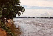
The Chindwin is served by regular river-going vessels up to the town of Homalin. TeakTeak
Teak is the common name for the tropical hardwood tree species Tectona grandis and its wood products. Tectona grandis is native to south and southeast Asia, mainly India, Indonesia, Malaysia, and Burma, but is naturalized and cultivated in many countries, including those in Africa and the...
forests within its drainage area have been a valuable resource since ancient times. The Hukawng Valley
Hukawng Valley
The Hukawng Valley is an isolated valley in Burma, roughly in area. It is located in Tanaing Township in the Myitkyina District of Kachin State in the northernmost part of the country.-Rivers:...
is known for its abundance of Burmese amber
Amber
Amber is fossilized tree resin , which has been appreciated for its color and natural beauty since Neolithic times. Amber is used as an ingredient in perfumes, as a healing agent in folk medicine, and as jewelry. There are five classes of amber, defined on the basis of their chemical constituents...
. Along the river, there are deposits of jade
Jade
Jade is an ornamental stone.The term jade is applied to two different metamorphic rocks that are made up of different silicate minerals:...
, but Hpakant
Hpakant
Hpakant , is a town in Hpakant Township, Kachin State of the northernmost part of the Union of Myanmar. It is located on the Uyu River 350 km north of Mandalay in the middle of one of the world's most inhospitable and malaria infested jungles, cut off for several months a year during the...
in the headwaters of the Uyu river is the only place in the world where the finest jade known as jadeite
Jadeite
Jadeite is a pyroxene mineral with composition NaAlSi2O6. It is monoclinic. It has a Mohs hardness of about 6.5 to 7.0 depending on the composition. The mineral is dense, with a specific gravity of about 3.4. Jadeite forms solid solutions with other pyroxene endmembers such as augite and diopside ,...
or Imperial Jade is found.