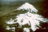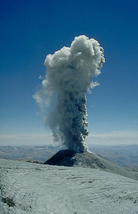
Sabancaya
Encyclopedia

Stratovolcano
A stratovolcano, also known as a composite volcano, is a tall, conical volcano built up by many layers of hardened lava, tephra, pumice, and volcanic ash. Unlike shield volcanoes, stratovolcanoes are characterized by a steep profile and periodic, explosive eruptions...
in the Andes
Andes
The Andes is the world's longest continental mountain range. It is a continual range of highlands along the western coast of South America. This range is about long, about to wide , and of an average height of about .Along its length, the Andes is split into several ranges, which are separated...
of southern Peru
Peru
Peru , officially the Republic of Peru , is a country in western South America. It is bordered on the north by Ecuador and Colombia, on the east by Brazil, on the southeast by Bolivia, on the south by Chile, and on the west by the Pacific Ocean....
, about 100 kilometres (62.1 mi) northwest of Arequipa
Arequipa
Arequipa is the capital city of the Arequipa Region in southern Peru. With a population of 836,859 it is the second most populous city of the country...
. It is the most active volcano in Peru and is part of a 20 kilometres (12.4 mi) north-south chain of three major stratovolcanoes, including the extinct and eroded 6025 metres (19,767.1 ft) Nevado Hualca Hualca at the northern end, the dormant 6288 metres (20,629.9 ft) Nevado Ampato
Ampato
Ampato is a dormant stratovolcano in the Andes of southern Peru, about 100 km northwest of Arequipa. It is part of a north-south chain of three major stratovolcanoes, including the extinct and eroded Nevado Hualca Hualca at the northern end and the active cone of Volcán Sabancaya in...
to the south, and Sabancaya in the middle. Sabancaya hosts several glacier
Glacier
A glacier is a large persistent body of ice that forms where the accumulation of snow exceeds its ablation over many years, often centuries. At least 0.1 km² in area and 50 m thick, but often much larger, a glacier slowly deforms and flows due to stresses induced by its weight...
s which cover an area of about 3.5 square kilometres (1.4 sq mi) and descend as low as 5400 metres (17,716.5 ft) on its flanks.
Volcanic activity
The andesiteAndesite
Andesite is an extrusive igneous, volcanic rock, of intermediate composition, with aphanitic to porphyritic texture. In a general sense, it is the intermediate type between basalt and dacite. The mineral assemblage is typically dominated by plagioclase plus pyroxene and/or hornblende. Magnetite,...
stratovolcano of Sabancaya has been very active during historic times, with the earliest recorded eruptions in 1695 and 1758 (other sources list 1750 and 1784 as possible eruptions, too). Following over 200 years of dormancy, satellites detected an increase in thermal emission in July 1986 and intense activity resumed in December of that year, with several eruptive cycles over the next two years producing a lava dome
Lava dome
|250px|thumb|right|Image of the [[rhyolitic]] lava dome of [[Chaitén Volcano]] during its 2008–2009 eruption.In volcanology, a lava dome is a roughly circular mound-shaped protrusion resulting from the slow extrusion of viscous lava from a volcano...
in the crater.
The most sustained period of activity began with explosive eruptions on May 28, 1990, and continued for over eight years. The eruptive cycle rated a VEI
Volcanic Explosivity Index
The Volcanic Explosivity Index was devised by Chris Newhall of the U.S. Geological Survey and Stephen Self at the University of Hawaii in 1982 to provide a relative measure of the explosiveness of volcanic eruptions....
of 3, with more than 25 million m3s (882,866,655.3 cu ft) of lava flows and tephra
Tephra
200px|thumb|right|Tephra horizons in south-central [[Iceland]]. The thick and light coloured layer at center of the photo is [[rhyolitic]] tephra from [[Hekla]]....
produced over that period. At the height of the activity in 1994, eruptions producing large ash clouds occurred every two hours. Although published topographic maps have not been revised since the eruptive cycyle, it is suspected that the cone may have grown to just over 6000 metres (19,685 ft) during that time. Additional smaller eruptions occurred in 2000 and 2003 Hasta el momentos no se sabe muy bien en el 2010 y 2011.
Volcanic hazards
Sabancaya is considered one of the most hazardous volcanoes in Peru, along with the massive CoropunaCoropuna
Nevado Coropuna is the largest and highest volcano in Peru, attaining an elevation of . It is located about northwest of Arequipa, the second largest city in Peru....
and the cone of El Misti
El Misti
El Misti, also known as Guagua-Putinais a stratovolcano located in southern Peru near the city of Arequipa. With its seasonally snow-capped, symmetrical cone, El Misti stands at above sea level and lies between the mountain Chachani and the volcano Pichu-Pichu . Its last eruption was in...
near Arequipa. As of the mid-1990s, over 8,000 people lived in the valleys draining the flanks of the volcano. Potential hazards include lahar
Lahar
A lahar is a type of mudflow or debris flow composed of a slurry of pyroclastic material, rocky debris, and water. The material flows down from a volcano, typically along a river valley. The term is a shortened version of "berlahar" which originated in the Javanese language of...
s and pyroclastic flow
Pyroclastic flow
A pyroclastic flow is a fast-moving current of superheated gas and rock , which reaches speeds moving away from a volcano of up to 700 km/h . The flows normally hug the ground and travel downhill, or spread laterally under gravity...
s down the Majes, Colca, and Siguas river drainages. During the 1988 eruption, cattle died in nearby areas either directly from poisonous volcanic gas
Volcanic gas
|250px|thumb|right|Image of the [[rhyolitic]] [[lava dome]] of [[Chaitén Volcano]] during its 2008-2010 eruption.Volcanic gases include a variety of substances given off by active volcanoes...
es or from eating contaminated vegetation.

