
Coropuna
Encyclopedia
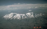
Nevado Coropuna is the largest and highest volcano
in Peru
, attaining an elevation of 6425 metres (21,079 ft). It is located about 150 km (93.2 mi) northwest of Arequipa
, the second largest city in Peru.
This massive ice-covered stratovolcano
complex has a summit plateau
which extends over 12 x 20 km (8 x 13 mi), with six separate summit cones rising above it. Three summits have over 300m of prominence , the true summit, 6425m, is at the northwest corner of the plateau. The southwest (Casulla) summit has an elevation of 6377m on the Peruvian IGM map but may be equal or greater in height depending on the depth of seasonal snow. A further summit with over 300m prominence is Coropuna Este 6307m. A permanent ice cap
of about 130 square kilometres (50 sq mi) in area covers the summit region, extending down to roughly 5300 metres (17,388.5 ft) on the north side and 4800 metres (15,748 ft) on the south. Vertical relief on the south flank exceeds 4000 metres (13,123.4 ft) over a distance of less than 15 km (9 mi).
The name Coropuna means "shrine on the plateau" in Quechua
. Coropuna was (and still is) one of the most sacred mountains in Peru, and in 1553 its temple was claimed to be the fifth most important shrine in the Inca Empire by the chronicler, Cieza de Leon. In 1982 Peruvian archaeologist José Antonio Chávez was able to briefly visit an Inca site called Achaymarca, which he felt was a likely candidate to be the temple of Coropuna. In 1989 Chávez and Johan Reinhard led an expedition to visit Achaymarca and surveyed the central ruins at 4,030 m (13,222 ft), which was part of a complex of over 200 structures, including an Inca ceremonial platform (ushnu). They also traced an Inca trail up to 5,500 m (18,044 ft) on the western slope of the mountain, where it disappeared beneath the glacier ice. Along this trail was an Inca site at 5,090 m (16,699 ft) that they named Ajocancha. In 1996 they organized another expedition which found wool and llama bones at 5,760 m (18,897 ft), llama bones and shards at 5,947 m (19,511 ft), and wood at 6,200 m (20,341 ft), providing evidence of pre-Columbian
ascents.
Another large Inca site, Maucallacta, has been investigated by Peruvian and Polish archaeologists in recent years. It lies several km to the east of Achaymarca at the head of a separate drainage system and also contains an ushnu and numerous structures. Thus two "temples" of primary importance had been established by the Incas on Coropuna's slopes.
More information about Maucallacta, the sacred Inca oracle of Coropuna, can be found in the web site: www.maucallacta.com http://www.maucallacta.com
Volcano
2. Bedrock3. Conduit 4. Base5. Sill6. Dike7. Layers of ash emitted by the volcano8. Flank| 9. Layers of lava emitted by the volcano10. Throat11. Parasitic cone12. Lava flow13. Vent14. Crater15...
in Peru
Peru
Peru , officially the Republic of Peru , is a country in western South America. It is bordered on the north by Ecuador and Colombia, on the east by Brazil, on the southeast by Bolivia, on the south by Chile, and on the west by the Pacific Ocean....
, attaining an elevation of 6425 metres (21,079 ft). It is located about 150 km (93.2 mi) northwest of Arequipa
Arequipa
Arequipa is the capital city of the Arequipa Region in southern Peru. With a population of 836,859 it is the second most populous city of the country...
, the second largest city in Peru.
This massive ice-covered stratovolcano
Stratovolcano
A stratovolcano, also known as a composite volcano, is a tall, conical volcano built up by many layers of hardened lava, tephra, pumice, and volcanic ash. Unlike shield volcanoes, stratovolcanoes are characterized by a steep profile and periodic, explosive eruptions...
complex has a summit plateau
Plateau
In geology and earth science, a plateau , also called a high plain or tableland, is an area of highland, usually consisting of relatively flat terrain. A highly eroded plateau is called a dissected plateau...
which extends over 12 x 20 km (8 x 13 mi), with six separate summit cones rising above it. Three summits have over 300m of prominence , the true summit, 6425m, is at the northwest corner of the plateau. The southwest (Casulla) summit has an elevation of 6377m on the Peruvian IGM map but may be equal or greater in height depending on the depth of seasonal snow. A further summit with over 300m prominence is Coropuna Este 6307m. A permanent ice cap
Ice cap
An ice cap is an ice mass that covers less than 50 000 km² of land area . Masses of ice covering more than 50 000 km² are termed an ice sheet....
of about 130 square kilometres (50 sq mi) in area covers the summit region, extending down to roughly 5300 metres (17,388.5 ft) on the north side and 4800 metres (15,748 ft) on the south. Vertical relief on the south flank exceeds 4000 metres (13,123.4 ft) over a distance of less than 15 km (9 mi).
The name Coropuna means "shrine on the plateau" in Quechua
Quechua languages
Quechua is a Native South American language family and dialect cluster spoken primarily in the Andes of South America, derived from an original common ancestor language, Proto-Quechua. It is the most widely spoken language family of the indigenous peoples of the Americas, with a total of probably...
. Coropuna was (and still is) one of the most sacred mountains in Peru, and in 1553 its temple was claimed to be the fifth most important shrine in the Inca Empire by the chronicler, Cieza de Leon. In 1982 Peruvian archaeologist José Antonio Chávez was able to briefly visit an Inca site called Achaymarca, which he felt was a likely candidate to be the temple of Coropuna. In 1989 Chávez and Johan Reinhard led an expedition to visit Achaymarca and surveyed the central ruins at 4,030 m (13,222 ft), which was part of a complex of over 200 structures, including an Inca ceremonial platform (ushnu). They also traced an Inca trail up to 5,500 m (18,044 ft) on the western slope of the mountain, where it disappeared beneath the glacier ice. Along this trail was an Inca site at 5,090 m (16,699 ft) that they named Ajocancha. In 1996 they organized another expedition which found wool and llama bones at 5,760 m (18,897 ft), llama bones and shards at 5,947 m (19,511 ft), and wood at 6,200 m (20,341 ft), providing evidence of pre-Columbian
Pre-Columbian
The pre-Columbian era incorporates all period subdivisions in the history and prehistory of the Americas before the appearance of significant European influences on the American continents, spanning the time of the original settlement in the Upper Paleolithic period to European colonization during...
ascents.
Another large Inca site, Maucallacta, has been investigated by Peruvian and Polish archaeologists in recent years. It lies several km to the east of Achaymarca at the head of a separate drainage system and also contains an ushnu and numerous structures. Thus two "temples" of primary importance had been established by the Incas on Coropuna's slopes.
More information about Maucallacta, the sacred Inca oracle of Coropuna, can be found in the web site: www.maucallacta.com http://www.maucallacta.com