
Rough Castle Fort
Encyclopedia
Rough Castle Fort is a Roman
fort
on the Antonine Wall
roughly 2 kilometres south east of Bonnybridge
near Tamfourhill
in the Falkirk council area
, Scotland
.
The Antonine Wall was built around 143 AD and stretched from Bo'ness
on the River Forth
to Old Kilpatrick
on the River Clyde
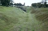
. The fort is the best preserved of the 19 forts constructed along the length of the Wall. Built against the southern rear face of the Wall, the fort was defended by 6 metre thick turf
ramparts
and surrounded by defensive ditches
. Gate
ways were provided through the main Wall to the north, and also through the walls on the other three sides of the fort. Causeways were then constructed across the main Antonine and secondary defensive ditches, affording easy access to and from the fort.
The fort was the second smallest on the Wall and had an area of about 4,000 square metres. The fort contained several substantial stone buildings, including a headquarters
, the commander
's house, barracks
, a bath house
and a granary
. Although the original buildings have not survived, the foundations of these buildings were discovered during excavations in 1902 - 1903, 1932 and 1957 - 1961.
Inscriptions found on recovered artifacts
indicate that the fort was the base for 480 men of the Sixth Cohort
of Nervii
(lat. Cohors VI Nerviorum, an infantry
unit recruited from a north eastern Gallic
tribe. The military way
on the south side of the Wall, which enabled transport between all forts, is still well defined, and there is also a fine length of rampart and ditch still intact to the west.
A feature of the defences at the fort, discovered during the excavations, is a series of pits lying to the north west of the causeway across the Antonine ditch. These pits, known as "lilias", would originally have contained sharpened stakes at the bottom. The lilias were positioned to help defend the vulnerable northern gateway through the Wall.
Roman Empire
The Roman Empire was the post-Republican period of the ancient Roman civilization, characterised by an autocratic form of government and large territorial holdings in Europe and around the Mediterranean....
fort
Fortification
Fortifications are military constructions and buildings designed for defence in warfare and military bases. Humans have constructed defensive works for many thousands of years, in a variety of increasingly complex designs...
on the Antonine Wall
Antonine Wall
The Antonine Wall is a stone and turf fortification built by the Romans across what is now the Central Belt of Scotland, between the Firth of Forth and the Firth of Clyde. Representing the northernmost frontier barrier of the Roman Empire, it spanned approximately 39 miles and was about ten feet ...
roughly 2 kilometres south east of Bonnybridge
Bonnybridge
Bonnybridge is a small town in the Falkirk council area of Scotland. It is west of Falkirk, north-east of Cumbernauld and south-southwest of Stirling. The town is situated near the Bonny Water which runs through the town and lies north of the Forth and Clyde Canal...
near Tamfourhill
Tamfourhill
Tamfourhill is a working-class residential suburb of Falkirk within the Falkirk , Scotland. It is located approximately 1.5 miles west of the city centre.The Falkirk Wheel is located just to the northwest of the village...
in the Falkirk council area
Falkirk (council area)
Falkirk is one of the 32 unitary authority council areas in Scotland. It borders onto North Lanarkshire to the south west, Stirling to the north west, West Lothian to the south east and, across the Firth of Forth to the north east, Fife and Clackmannanshire...
, Scotland
Scotland
Scotland is a country that is part of the United Kingdom. Occupying the northern third of the island of Great Britain, it shares a border with England to the south and is bounded by the North Sea to the east, the Atlantic Ocean to the north and west, and the North Channel and Irish Sea to the...
.
The Antonine Wall was built around 143 AD and stretched from Bo'ness
Bo'ness
Bo'ness, properly Borrowstounness, is a coastal town in the Central Lowlands of Scotland. It lies on a hillside on the south bank of the Firth of Forth within the Falkirk council area, north-west of Edinburgh and east of Falkirk. At the 2001 census, Bo'ness had a resident population of 13,961...
on the River Forth
River Forth
The River Forth , long, is the major river draining the eastern part of the central belt of Scotland.The Forth rises in Loch Ard in the Trossachs, a mountainous area some west of Stirling...
to Old Kilpatrick
Old Kilpatrick
Old Kilpatrick is a village in West Dunbartonshire, Scotland.The village is on the north bank of the River Clyde immediately to the north of the Forth and Clyde Canal, three miles from Clydebank on the road to Dumbarton. The Great Western Road runs through Old Kilpatrick, and the next village to...
on the River Clyde
River Clyde
The River Clyde is a major river in Scotland. It is the ninth longest river in the United Kingdom, and the third longest in Scotland. Flowing through the major city of Glasgow, it was an important river for shipbuilding and trade in the British Empire....
. The fort is the best preserved of the 19 forts constructed along the length of the Wall. Built against the southern rear face of the Wall, the fort was defended by 6 metre thick turf
Sod
Sod or turf is grass and the part of the soil beneath it held together by the roots, or a piece of thin material.The term sod may be used to mean turf grown and cut specifically for the establishment of lawns...
ramparts
Defensive wall
A defensive wall is a fortification used to protect a city or settlement from potential aggressors. In ancient to modern times, they were used to enclose settlements...
and surrounded by defensive ditches
Ditch (fortification)
A ditch in military engineering is an obstacle, designed to slow down or break up an attacking force, while a trench is intended to provide cover to the defenders...
. Gate
Gate
A gate is a point of entry to a space enclosed by walls, or a moderately sized opening in a fence. Gates may prevent or control entry or exit, or they may be merely decorative. Other terms for gate include yett and port...
ways were provided through the main Wall to the north, and also through the walls on the other three sides of the fort. Causeways were then constructed across the main Antonine and secondary defensive ditches, affording easy access to and from the fort.
The fort was the second smallest on the Wall and had an area of about 4,000 square metres. The fort contained several substantial stone buildings, including a headquarters
Headquarters
Headquarters denotes the location where most, if not all, of the important functions of an organization are coordinated. In the United States, the corporate headquarters represents the entity at the center or the top of a corporation taking full responsibility managing all business activities...
, the commander
Commander
Commander is a naval rank which is also sometimes used as a military title depending on the individual customs of a given military service. Commander is also used as a rank or title in some organizations outside of the armed forces, particularly in police and law enforcement.-Commander as a naval...
's house, barracks
Barracks
Barracks are specialised buildings for permanent military accommodation; the word may apply to separate housing blocks or to complete complexes. Their main object is to separate soldiers from the civilian population and reinforce discipline, training and esprit de corps. They were sometimes called...
, a bath house
Public bathing
Public baths originated from a communal need for cleanliness. The term public may confuse some people, as some types of public baths are restricted depending on membership, gender, religious affiliation, or other reasons. As societies have changed, public baths have been replaced as private bathing...
and a granary
Granary
A granary is a storehouse for threshed grain or animal feed. In ancient or primitive granaries, pottery is the most common use of storage in these buildings. Granaries are often built above the ground to keep the stored food away from mice and other animals.-Early origins:From ancient times grain...
. Although the original buildings have not survived, the foundations of these buildings were discovered during excavations in 1902 - 1903, 1932 and 1957 - 1961.
Inscriptions found on recovered artifacts
Artifact (archaeology)
An artifact or artefact is "something made or given shape by man, such as a tool or a work of art, esp an object of archaeological interest"...
indicate that the fort was the base for 480 men of the Sixth Cohort
Cohort (military unit)
A cohort was the basic tactical unit of a Roman legion following the reforms of Gaius Marius in 107 BC.-Legionary cohort:...
of Nervii
Nervii
The Nervii were an ancient Germanic tribe, and one of the most powerful Belgic tribes; living in the northeastern hinterlands of Gaul, they were known to trek long distances to engage in various wars and functions...
(lat. Cohors VI Nerviorum, an infantry
Infantry
Infantrymen are soldiers who are specifically trained for the role of fighting on foot to engage the enemy face to face and have historically borne the brunt of the casualties of combat in wars. As the oldest branch of combat arms, they are the backbone of armies...
unit recruited from a north eastern Gallic
Gaul
Gaul was a region of Western Europe during the Iron Age and Roman era, encompassing present day France, Luxembourg and Belgium, most of Switzerland, the western part of Northern Italy, as well as the parts of the Netherlands and Germany on the left bank of the Rhine. The Gauls were the speakers of...
tribe. The military way
Roman road
The Roman roads were a vital part of the development of the Roman state, from about 500 BC through the expansion during the Roman Republic and the Roman Empire. Roman roads enabled the Romans to move armies and trade goods and to communicate. The Roman road system spanned more than 400,000 km...
on the south side of the Wall, which enabled transport between all forts, is still well defined, and there is also a fine length of rampart and ditch still intact to the west.
A feature of the defences at the fort, discovered during the excavations, is a series of pits lying to the north west of the causeway across the Antonine ditch. These pits, known as "lilias", would originally have contained sharpened stakes at the bottom. The lilias were positioned to help defend the vulnerable northern gateway through the Wall.