
Rothersthorpe
Encyclopedia
Rothersthorpe is a small village of medieval origin, in South Northamptonshire
, England
, with a population of 500 in the 2001 Census
. It is 4 miles (6 km) from the town of Northampton
.
District Council and Harpole and Grange ward, together with the villages of Milton Malsor
, Gayton
, Harpole
and Kislingbury
. The ward had a total population of 1,721 in the 2001 census. The village is part of the Northampton South constituency which is represented by the Conservative
Member of Parliament
, Brian Binley
. For the next General Election
in 2010 or before the village will be in Daventry
constituency.
period to the later 12th century. They are situated between the junction of North Street and Church Street and were small defended areas of buildings surrounded partly or completely by large ditches and earthworks
topped by wooden palisade
s. They are rare nationally.
The Berry is the site of a ringwork which stood at the centre of medieval Rothersthorpe. The site is irregularly shaped with a wide ditch on the north and west sides. There are the remains of an inner rampart
in the north east corner and southern end. Features in the west of the interior of the works show the locations of former buildings. Remains of ridge and furrow farming are on the eastern side.
shows 500 people living in the parish, 237 male and 263 female, in 191 dwellings.
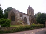
, The Chequers, and the church of SS Peter and Paul.
The M1 Motorway
with the Northampton (formerly known as Rothersthorpe) Service Area and junction 15A is nearby but mostly out of hearing as the prevailing wind is south-westerly. There is, however, light pollution from the service area and a large area of warehouses in the nearby area of Northampton.
The Northampton Arm of the Grand Union Canal
, built in 1815 passes near to Rothersthorpe. Seventeen locks, taking the canal into Northampton and its junction with the River Nene
, take about two hours for a boat to travel through.
 The village is bisected by the Banbury Lane, an ancient Drovers' road along which cattle were once taken to market in Banbury
from as far afield as Scotland
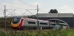
. Along this road a mile or so south was a level crossing
with the West Coast Main Line
railway route from Euston
to Glasgow
, Scotland. The crossing was one of few left on the line and the first outside Euston, some 65 miles south. The level crossing and an adjacent bridge over the Grand Union Canal were replaced by a curved bridge in 2005. This was for safety reasons following projected speed increases to 125 miles per hour on the line by Virgin Trains
' tilting Pendolino
trains.
South Northamptonshire
South Northamptonshire is a local government district in Northamptonshire, England. Its council is based in Towcester.The district is rural and sparsely populated with just over 79,293 people in 2000 and 91,000 in 2008, a 14.8% increase. The largest town in the district is Brackley, which has a...
, England
England
England is a country that is part of the United Kingdom. It shares land borders with Scotland to the north and Wales to the west; the Irish Sea is to the north west, the Celtic Sea to the south west, with the North Sea to the east and the English Channel to the south separating it from continental...
, with a population of 500 in the 2001 Census
United Kingdom Census 2001
A nationwide census, known as Census 2001, was conducted in the United Kingdom on Sunday, 29 April 2001. This was the 20th UK Census and recorded a resident population of 58,789,194....
. It is 4 miles (6 km) from the town of Northampton
Northampton
Northampton is a large market town and local government district in the East Midlands region of England. Situated about north-west of London and around south-east of Birmingham, Northampton lies on the River Nene and is the county town of Northamptonshire. The demonym of Northampton is...
.
Governance
The village is in the area of South NorthamptonshireSouth Northamptonshire
South Northamptonshire is a local government district in Northamptonshire, England. Its council is based in Towcester.The district is rural and sparsely populated with just over 79,293 people in 2000 and 91,000 in 2008, a 14.8% increase. The largest town in the district is Brackley, which has a...
District Council and Harpole and Grange ward, together with the villages of Milton Malsor
Milton Malsor
Milton Malsor is a village and civil parish in South Northamptonshire, England. It is south of Northampton, south-east of Birmingham, and north of central London; junction 15 of the M1 motorway is east by road...
, Gayton
Gayton, Northamptonshire
Gayton is a rural village from Northampton town centre in South Northamptonshire. It is situated on a hill close to the larger villages of Bugbrooke, Milton Malsor and Blisworth, with a linked public footpath network. -History:...
, Harpole
Harpole
Harpole Northamptonshire, England, is a village west of Northampton, in the district council area of South Northamptonshire where it is part of Harpole and Grange ward, together with the parishes of Milton Malsor, Kislingbury, Rothersthorpe and Gayton. It is within the area of Northamptonshire...
and Kislingbury
Kislingbury
Kislingbury is a village in Northamptonshire, England, about west of Northampton town centre, and close to junctions 15A and 16 of the M1 motorway.-Demographics:...
. The ward had a total population of 1,721 in the 2001 census. The village is part of the Northampton South constituency which is represented by the Conservative
Conservative Party (UK)
The Conservative Party, formally the Conservative and Unionist Party, is a centre-right political party in the United Kingdom that adheres to the philosophies of conservatism and British unionism. It is the largest political party in the UK, and is currently the largest single party in the House...
Member of Parliament
Member of Parliament
A Member of Parliament is a representative of the voters to a :parliament. In many countries with bicameral parliaments, the term applies specifically to members of the lower house, as upper houses often have a different title, such as senate, and thus also have different titles for its members,...
, Brian Binley
Brian Binley
Brian Arthur Roland Binley is a British Conservative politician, and the Member of Parliament for Northampton South.-Early life:...
. For the next General Election
General election
In a parliamentary political system, a general election is an election in which all or most members of a given political body are chosen. The term is usually used to refer to elections held for a nation's primary legislative body, as distinguished from by-elections and local elections.The term...
in 2010 or before the village will be in Daventry
Daventry (UK Parliament constituency)
Daventry is a county constituency represented in the House of Commons of the Parliament of the United Kingdom. It is a strongly Conservative seat.- Boundaries :The constituency covers the west of Northamptonshire and is named for the market town of Daventry...
constituency.
History
The Berry ringworks are medieval fortifications built and occupied from the late Anglo-SaxonAnglo-Saxon
Anglo-Saxon may refer to:* Anglo-Saxons, a group that invaded Britain** Old English, their language** Anglo-Saxon England, their history, one of various ships* White Anglo-Saxon Protestant, an ethnicity* Anglo-Saxon economy, modern macroeconomic term...
period to the later 12th century. They are situated between the junction of North Street and Church Street and were small defended areas of buildings surrounded partly or completely by large ditches and earthworks
Earthworks (archaeology)
In archaeology, earthwork is a general term to describe artificial changes in land level. Earthworks are often known colloquially as 'lumps and bumps'. Earthworks can themselves be archaeological features or they can show features beneath the surface...
topped by wooden palisade
Palisade
A palisade is a steel or wooden fence or wall of variable height, usually used as a defensive structure.- Typical construction :Typical construction consisted of small or mid sized tree trunks aligned vertically, with no spacing in between. The trunks were sharpened or pointed at the top, and were...
s. They are rare nationally.
The Berry is the site of a ringwork which stood at the centre of medieval Rothersthorpe. The site is irregularly shaped with a wide ditch on the north and west sides. There are the remains of an inner rampart
Defensive wall
A defensive wall is a fortification used to protect a city or settlement from potential aggressors. In ancient to modern times, they were used to enclose settlements...
in the north east corner and southern end. Features in the west of the interior of the works show the locations of former buildings. Remains of ridge and furrow farming are on the eastern side.
Demographics
The 2001 CensusUnited Kingdom Census 2001
A nationwide census, known as Census 2001, was conducted in the United Kingdom on Sunday, 29 April 2001. This was the 20th UK Census and recorded a resident population of 58,789,194....
shows 500 people living in the parish, 237 male and 263 female, in 191 dwellings.
Facilities
The village has a mixed Church of England primary school, a pubPublic house
A public house, informally known as a pub, is a drinking establishment fundamental to the culture of Britain, Ireland, Australia and New Zealand. There are approximately 53,500 public houses in the United Kingdom. This number has been declining every year, so that nearly half of the smaller...
, The Chequers, and the church of SS Peter and Paul.
The M1 Motorway
M1 motorway
The M1 is a north–south motorway in England primarily connecting London to Leeds, where it joins the A1 near Aberford. While the M1 is considered to be the first inter-urban motorway to be completed in the United Kingdom, the first road to be built to motorway standard in the country was the...
with the Northampton (formerly known as Rothersthorpe) Service Area and junction 15A is nearby but mostly out of hearing as the prevailing wind is south-westerly. There is, however, light pollution from the service area and a large area of warehouses in the nearby area of Northampton.
The Northampton Arm of the Grand Union Canal
Grand Union Canal
The Grand Union Canal in England is part of the British canal system. Its main line connects London and Birmingham, stretching for 137 miles with 166 locks...
, built in 1815 passes near to Rothersthorpe. Seventeen locks, taking the canal into Northampton and its junction with the River Nene
River Nene
The River Nene is a river in the east of England that rises from three sources in the county of Northamptonshire. The tidal river forms the border between Cambridgeshire and Norfolk for about . It is the tenth longest river in the United Kingdom, and is navigable for from Northampton to The...
, take about two hours for a boat to travel through.
Banbury
Banbury is a market town and civil parish on the River Cherwell in the Cherwell District of Oxfordshire. It is northwest of London, southeast of Birmingham, south of Coventry and north northwest of the county town of Oxford...
from as far afield as Scotland
Scotland
Scotland is a country that is part of the United Kingdom. Occupying the northern third of the island of Great Britain, it shares a border with England to the south and is bounded by the North Sea to the east, the Atlantic Ocean to the north and west, and the North Channel and Irish Sea to the...
. Along this road a mile or so south was a level crossing
Level crossing
A level crossing occurs where a railway line is intersected by a road or path onone level, without recourse to a bridge or tunnel. It is a type of at-grade intersection. The term also applies when a light rail line with separate right-of-way or reserved track crosses a road in the same fashion...
with the West Coast Main Line
West Coast Main Line
The West Coast Main Line is the busiest mixed-traffic railway route in Britain, being the country's most important rail backbone in terms of population served. Fast, long-distance inter-city passenger services are provided between London, the West Midlands, the North West, North Wales and the...
railway route from Euston
Euston railway station
Euston railway station, also known as London Euston, is a central London railway terminus in the London Borough of Camden. It is the sixth busiest rail terminal in London . It is one of 18 railway stations managed by Network Rail, and is the southern terminus of the West Coast Main Line...
to Glasgow
Glasgow
Glasgow is the largest city in Scotland and third most populous in the United Kingdom. The city is situated on the River Clyde in the country's west central lowlands...
, Scotland. The crossing was one of few left on the line and the first outside Euston, some 65 miles south. The level crossing and an adjacent bridge over the Grand Union Canal were replaced by a curved bridge in 2005. This was for safety reasons following projected speed increases to 125 miles per hour on the line by Virgin Trains
Virgin Trains
Virgin Trains is a train operating company in the United Kingdom. It operates long-distance passenger services on the West Coast Main Line between London, the West Midlands, North West England, North Wales and Scotland...
' tilting Pendolino
Pendolino
Pendolino is an Italian family of tilting trains used in Italy, Spain, Portugal, Slovenia, Finland, Russian Federation, the Czech Republic, the United Kingdom, Slovakia, Switzerland, China and shortly in Romania and Poland...
trains.