
Roi Et Province
Encyclopedia
Roi Et is one of the provinces
(changwat) of Thailand
, located in the North-East
of Thailand. Neighboring Provinces are (from north clockwise) Kalasin
, Mukdahan
, Yasothon
, Sisaket
, Surin
and Maha Sarakham
.
The Name Roi Et translates to 101, which refers to the original 11 satellite cities around the main city as well as the 11 city gates. To express the importance of the city the number was exaggerated.
. In the north of the province are the hills of the Phu Phan mountain range
, with the Yang River as the major river. In the south is the Mun River
, which also forms the boundary to the province of Surin. At the mouth of the Chi River, where it enters the Mun River, a big flooded basin provides a good rice
farming area.

, as several ruins show. However, the main history of the province began when Lao
people from Champasak
settled near Suwannaphum during the Ayutthaya Kingdom
. In the late 18th century, King Taksin
moved the city to its present site, then called Saket Nakhon.
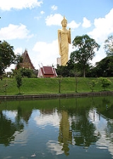
shows the shrine of the city pillar
, which is located in the artificial lake Bueng Phlan Chai. The spirit of the shrine, Mahesak, is highly revered by the local people.
The provincial tree is Lagerstroemia macrocarpa.
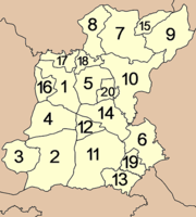
 The province is subdivided into 20 districts (amphoe
). The districts are further subdivided into 193 subdistricts (tambon
) and 2311 villages (muban
).
The Monument of Phra Khattiyawongsa (Thon) (อนุสาวรีย์พระขัติยะวงษา (ทน) Phra Khattiyawongsa (Thon) was appointed the first ruler of Roi Et. He was considered a great ruler who developed the city until Roi Et became one of the most prosperous cities in the region.
Somdech Phra Srinakarindra Park Roi Et (สวนสมเด็จพระศรีนครินทร์ร้อยเอ็ด): It is a public park in the heart of the city, located in front of the city hall. The highlight is the fountain in the middle of the park and a clock tower. The park is used as a venue for various cultural occasions and events of the province.
Bueng Phalan Chai (บึงพลาญชัย): The picturesque lake with an area of 200,000 sq.m. is a symbol of Roi Et. Inside is situated the city pillar shrine, a sacred shrine that is highly revered by the people of Roi Et. There is also a large walking Buddha image, a Constitution atop a footed tray, flower clock, Phu Phalan Chai (an artificial waterfall), and animal sculptures.
Mueang Roi Et Municipality Aquarium (สถานแสดงพันธุ์สัตว์น้ำเทศบาลเมืองร้อยเอ็ด): One of its twin buildings comprises an auditorium, lecture room, exhibition room, office, and ticket booth. The next building features an aquarium displaying fresh water fish. The highlight of the exhibition is the underwater tunnel through which one can view the movements of marine animals from any direction.
Wat Klang Ming Mueang (วัดกลางมิ่งเมือง): The Ubosot was built during the late Ayutthaya period. In the past, it was used for the Oath of Allegiance Ceremony. At present, it is a venue for dharma practice and is known as Sunthon Thamma Pariyat School.
Wat Sa Thong (วัดสระทอง): The temple houses Luangpho Phra Sangkatchai (Kaccayana), a sacred Buddha image highly revered by the people of Roi Et. Phraya Khattiyawongsa (Thon), the first founder of Roi Et, discovered this image.
Wat Buraphaphiram (วัดบูรพาภิราม): There is the tallest standing Buddha image in Thailand known as Phra Phuttha Rattanamongkhon Mahamuni or Luangpho Yai, which was built with reinforced concrete and stands in the blessing attitude.
Prang Ku or Prasat Nong Ku (ปรางค์กู่ หรือ ปราสาทหนองกู่): is a complex of buildings with a plan that resembles the Khmer nursing home known as ‘Arogayasala’. It comprises the main prang, a library, wall and entrance pavilions, and a pond outside of the wall. The ruins are in good condition, especially the roof structure of the main prang.
Wat Pa Non Sawan (วัดป่าโนนสวรรค์): It is a huge temple built from the abbot’s omen. It was embellished and decorated with local earthenware, so it looks strikingly eye-catching. The entrance of the multi-tiered chedi represents Hanuman’s mouth.
Bo Phan Khan Rattanasophon (บ่อพันขันรัตนโสภณ): The park was set up to commemorate the 50th Anniversary Celebrations of His Majesty’s Accession to the Throne. It is also where the beautiful image of Phra Phuttha Sahatsakhantha Mahamuninat is located.
Ban Wai Luem (บ้านหวายหลึม): The village famous for silk weaving is part of the province’s One Tambon One Product (OTOP) project, so it is also the distribution centre for local handicraft products such as handbags, cotton, and ready-to-wear clothes.
Ku Ka Sing (กู่กาสิงห์): It is another huge temple with Khmer-style architecture, comprising three prangs on the same laterite base, and rectangular library buildings in front. All of them are surrounded by a wall, with entrance pavilions known as Gopura at the four directions. Outside is a U-shaped moat surrounding the wall.
Tung Kula Rong Hai
(ทุ่งกุลาร้องไห้) The legend of Thung Kula Ronghai had it that, in ancient times, there were Kula people who travelled around for trading; they were known for being strong and tolerant. But when they reached this field, the hardship even made them cry (Ronghai) because there was not a single drop of water or big trees in sight.
Ku Phra Kona (กู่พระโกนา) : comprises three east-facing brick prangs lying in the north – south direction, standing on a single sandstone base. They are surrounded by a boundary wall, with entrance pavilions or Gopuras in four directions; all were made from sandstone.
Sim Wat Traiphum Khanachan (สิมวัดไตรภูมิคณาจารย์): The architectural structure suggests that it is a traditional small ‘Sim’ – local dialect for Ubosot - of the Northeast with a low boundary wall. Sim Wat Traiphum Khanachan was awarded for outstanding architecture by the Association of Siamese Architects under Royal Patronage.
Bueng Kluea (Salt Lake or Sea of Isan) (บึงเกลือ หรือ ทะเลอีสาน): Situated in Tambon Bueng Klua, it is a large lake covering a total area of 7,500 rai, with water all year round.
Sim Wat Chakkrawan Phum Phinit or Wat Nong Muen Than (สิมวัดจักรวาฬภูมิพินิจ หรือ วัดหนองหมื่นถ่าน): It features a small ‘Sim’ of traditional northeastern style. Its gable and ‘Rang Phueng’ (decoration underneath the lower tie beam) feature fine woodcarving with a wooden shingle roof. Outside is decorated with mural paintings.
Pha Nam Yoi or Isan Buddhist Park (ผาน้ำย้อย หรือ พุทธอุทยานอีสาน): It covers a forest with wide varieties of hardwood trees and is home to various kinds of wild animals. On the hill is situated Wat Pha Namthip Thep Prasit Wanaram. The temple houses Phra Mahachedi Chai Mongkhon, one of Thailand’s largest chedis.
Literature Botanical Garden (สวนพฤกษศาสตร์วรรณคดี): It is the regional literature botanical garden of the Northeast. It covers a total area of about 1,000 rai, featuring plants mentioned in Thai literature.
Tham Pha Nam Thip Non-hunting Area (เขตห้ามล่าสัตว์ป่าถ้ำผาน้ำทิพย์): It comprises steep and complex undulating sandstone mountains with abundant dry evergreen forest, deciduous forest, and deciduous dipterocarp forest. Fauna found in this area include boars, barking deer, foxes, monkeys, squirrels, etc.
Pha Mok Mi Wai (ผาหมอกมิวาย): Situated inside Pha Nam Thip Non-hunting Area, it is the best viewpoint and is covered with mist all year round, as it is an abundant area with high humidity.
Kin Khao Pun Bun Phawet Festival : First held in 1991, it has been held annually around early March every year ever since. The event takes place at the Somdech Phra Srinakarindra Park and Bueng Phalan Chai. Bun Phawet, or known in the Central Region as Bun Mahachat, is usually held in the 4th lunar month. It is a Buddhist ceremony in which the monks give a sermon of all chapters of the Vessantara Jataka, otherwise called the Great Birth Sermon. There are also 13 parades of Phawet, according to the number of the chapters of the sermon, arranged by various public and private organisations. The area around Bueng Phalan Chai has stalls providing free ‘Khao Pun’ - rice noodle - for participants. There are also contests of traditional arts and culture such as making the ‘bai si su khwan’ tray.
Bun Bangfai Festival (aka 'The Rocket Festival
'): The festival is organised annually around June. Every district will organise colourful parades of Bangfai rockets that reflect the folk culture and local traditions of Roi Et province, especially the parades from Phanom Phrai and Suwannaphum districts will be lavishly decorated.
Candle Festival : It is organised annually on Asalha Puja Day at the Somdech Phra Srinakarindra Park. Each temple will beautifully decorate their candle floats with colourful flowers, and the parade will move along the road via the market to the cruciform pavilion in the Park. There will also be contests of decorated candles and floats with cultural performances.
Long Boat Races of Tambon Mueang Bua, Kaset Wisai District : The event is held annually at the end of the Buddhist Lent, or around mid-October when there is plenty of water in the river. Boats joining the races are from Roi Et and nearby provinces including Kalasin, Maha Sarakham, Si Sa Ket, and Nakhon Ratchasima.
Provinces of Thailand
Thailand is divided into 76 provinces , which are geographically grouped into 6 regions. The capital Bangkok is not a province but a special administrative area and is included as the 77th province since it is administered at the same level as the other 76 provinces. The name of the provinces are...
(changwat) of Thailand
Thailand
Thailand , officially the Kingdom of Thailand , formerly known as Siam , is a country located at the centre of the Indochina peninsula and Southeast Asia. It is bordered to the north by Burma and Laos, to the east by Laos and Cambodia, to the south by the Gulf of Thailand and Malaysia, and to the...
, located in the North-East
Isan
Isan is the northeastern region of Thailand. It is located on the Khorat Plateau, bordered by the Mekong River to the north and east, by Cambodia to the southeast and the Prachinburi mountains south of Nakhon Ratchasima...
of Thailand. Neighboring Provinces are (from north clockwise) Kalasin
Kalasin Province
Kalasin is one of the provinces of Thailand, located in the North-East of Thailand. Neighboring provinces are Sakon Nakhon, Mukdahan, Roi Et, Maha Sarakham, Khon Kaen and Udon Thani.-Geography:...
, Mukdahan
Mukdahan Province
Mukdahan is one of the north-eastern provinces of Thailand. Neighboring provinces are Amnat Charoen, Yasothon, Roi Et, Kalasin, Sakon Nakhon and Nakhon Phanom. To the east it borders the Mekong River, across which lies Savannakhet Province of Laos.-Geography:The province is located in the...
, Yasothon
Yasothon Province
Yasothon is one of the provinces of Thailand, located in the North-East of Thailand on the Chi River. Neighboring provinces are Mukdahan, Amnat Charoen, Ubon Ratchathani, Sisaket and Roi Et.-Geography:...
, Sisaket
Sisaket Province
Sisaket , is one of the north-eastern provinces of Thailand. Neighboring provinces are Surin, Roi Et, Yasothon and Ubon Ratchathani. To the south it borders Oddar Meancheay and Preah Vihear of Cambodia.-Geography:...
, Surin
Surin Province
Surin is one of the north-eastern provinces of Thailand. Neighboring provinces are Buriram, Maha Sarakham, Roi Et and Sisaket...
and Maha Sarakham
Maha Sarakham Province
Maha Sarakham is one of the provinces of Thailand, located in the northeastern region of Thailand. Neighboring provinces are Kalasin, Roi Et, Surin, Buriram and Khon Kaen....
.
The Name Roi Et translates to 101, which refers to the original 11 satellite cities around the main city as well as the 11 city gates. To express the importance of the city the number was exaggerated.
Geography
Most part of the province is covered by plains about 130-160 meters above sea level, drained by the Chi RiverChi River
The Chi River is the longest river in Thailand; it extends 765 km, but carries less water than the second longest river, the Mun. In the Isan dialect of this region, and also in the adjacent language Lao, the name of the river is actually pronounced "Nam Si" but the transliteration Chi...
. In the north of the province are the hills of the Phu Phan mountain range
Phu Phan Mountains
The Phu Phan mountains are a range of hills dividing the Khorat Plateau of the Isan region of Thailand into two basins: the northern Sakhon Nakhon Basin, and the southern Khorat Basin.-Etymology:...
, with the Yang River as the major river. In the south is the Mun River
Mun River
The Mun River , sometimes spelled Moon River, is a tributary of the Mekong river. It carries approximately 21,000 cubic kilometres of water per year.-Geography:...
, which also forms the boundary to the province of Surin. At the mouth of the Chi River, where it enters the Mun River, a big flooded basin provides a good rice
Rice
Rice is the seed of the monocot plants Oryza sativa or Oryza glaberrima . As a cereal grain, it is the most important staple food for a large part of the world's human population, especially in East Asia, Southeast Asia, South Asia, the Middle East, and the West Indies...
farming area.
History
The area was already settled during the times of the Khmer empireKhmer Empire
The Khmer Empire was one of the most powerful empires in Southeast Asia. The empire, which grew out of the former kingdom of Chenla, at times ruled over and/or vassalized parts of modern-day Laos, Thailand, Vietnam, Burma, and Malaysia. Its greatest legacy is Angkor, the site of the capital city...
, as several ruins show. However, the main history of the province began when Lao
Lao people
The Lao are an ethnic subgroup of Tai/Dai in Southeast Asia.-Names:The etymology of the word Lao is uncertain, although it may be related to tribes known as the Ai Lao who appear in Han Dynasty records in China and Vietnam as a people of what is now Yunan Province...
people from Champasak
Champasak
Champasak may refer to* Champasak Province* Champasak * Kingdom of Champasak* Na Champassak family...
settled near Suwannaphum during the Ayutthaya Kingdom
Ayutthaya kingdom
Ayutthaya was a Siamese kingdom that existed from 1350 to 1767. Ayutthaya was friendly towards foreign traders, including the Chinese, Vietnamese , Indians, Japanese and Persians, and later the Portuguese, Spanish, Dutch and French, permitting them to set up villages outside the walls of the...
. In the late 18th century, King Taksin
Taksin
Taksin ; was the only King of the Thonburi Kingdom...
moved the city to its present site, then called Saket Nakhon.
Symbols
The provincial sealSeals of The Provinces of Thailand
-Present-day provinces of Thailand:This list includes all the seals of the Provinces of Thailand. It also includes the special administrative area of the capital, Bangkok.-Former Provinces:-External links:*...
shows the shrine of the city pillar
Lak Mueang
Lak Mueang are City pillars found in most cities of Thailand. Usually housed in a shrine which is also believed to house Chao Pho Lak Mueang , the city spirit deity; it is held in high esteem by citizens....
, which is located in the artificial lake Bueng Phlan Chai. The spirit of the shrine, Mahesak, is highly revered by the local people.
The provincial tree is Lagerstroemia macrocarpa.
Administrative divisions
Amphoe
An amphoe is the second level administrative subdivision of Thailand. Usually translated as district, amphoe make up the provinces, and are analogous to a county seat...
). The districts are further subdivided into 193 subdistricts (tambon
Tambon
Tambon is a local government unit in Thailand. Below district and province , they form the third administrative subdivision level. As of the 2009 there are 7255 tambon, not including the 169 khwaeng of Bangkok, which are set at the same administrative level, thus every district contains 8-10 tambon...
) and 2311 villages (muban
Muban
Muban is the lowest administrative subdivision of Thailand. Usually translated as village, they are the subdivision of tambon. As of 2008, there are 74944 administrative villages in Thailand. As of the 1990 census, the average village consisted of 144 households or 746 persons.A muban does not...
).
|
|
Sights
Roi Et National Museum (พิพิธภัณฑสถานแห่งชาติ ร้อยเอ็ด): It was initially established by Dr. Ko Sawatdiphanit with the aim of showcasing local silk textiles and the handicrafts of Roi Et. It was later renovated when the Fine Arts Department developed a policy for setting up a national museum.The Monument of Phra Khattiyawongsa (Thon) (อนุสาวรีย์พระขัติยะวงษา (ทน) Phra Khattiyawongsa (Thon) was appointed the first ruler of Roi Et. He was considered a great ruler who developed the city until Roi Et became one of the most prosperous cities in the region.
Somdech Phra Srinakarindra Park Roi Et (สวนสมเด็จพระศรีนครินทร์ร้อยเอ็ด): It is a public park in the heart of the city, located in front of the city hall. The highlight is the fountain in the middle of the park and a clock tower. The park is used as a venue for various cultural occasions and events of the province.
Bueng Phalan Chai (บึงพลาญชัย): The picturesque lake with an area of 200,000 sq.m. is a symbol of Roi Et. Inside is situated the city pillar shrine, a sacred shrine that is highly revered by the people of Roi Et. There is also a large walking Buddha image, a Constitution atop a footed tray, flower clock, Phu Phalan Chai (an artificial waterfall), and animal sculptures.
Mueang Roi Et Municipality Aquarium (สถานแสดงพันธุ์สัตว์น้ำเทศบาลเมืองร้อยเอ็ด): One of its twin buildings comprises an auditorium, lecture room, exhibition room, office, and ticket booth. The next building features an aquarium displaying fresh water fish. The highlight of the exhibition is the underwater tunnel through which one can view the movements of marine animals from any direction.
Wat Klang Ming Mueang (วัดกลางมิ่งเมือง): The Ubosot was built during the late Ayutthaya period. In the past, it was used for the Oath of Allegiance Ceremony. At present, it is a venue for dharma practice and is known as Sunthon Thamma Pariyat School.
Wat Sa Thong (วัดสระทอง): The temple houses Luangpho Phra Sangkatchai (Kaccayana), a sacred Buddha image highly revered by the people of Roi Et. Phraya Khattiyawongsa (Thon), the first founder of Roi Et, discovered this image.
Wat Buraphaphiram (วัดบูรพาภิราม): There is the tallest standing Buddha image in Thailand known as Phra Phuttha Rattanamongkhon Mahamuni or Luangpho Yai, which was built with reinforced concrete and stands in the blessing attitude.
Prang Ku or Prasat Nong Ku (ปรางค์กู่ หรือ ปราสาทหนองกู่): is a complex of buildings with a plan that resembles the Khmer nursing home known as ‘Arogayasala’. It comprises the main prang, a library, wall and entrance pavilions, and a pond outside of the wall. The ruins are in good condition, especially the roof structure of the main prang.
Wat Pa Non Sawan (วัดป่าโนนสวรรค์): It is a huge temple built from the abbot’s omen. It was embellished and decorated with local earthenware, so it looks strikingly eye-catching. The entrance of the multi-tiered chedi represents Hanuman’s mouth.
Bo Phan Khan Rattanasophon (บ่อพันขันรัตนโสภณ): The park was set up to commemorate the 50th Anniversary Celebrations of His Majesty’s Accession to the Throne. It is also where the beautiful image of Phra Phuttha Sahatsakhantha Mahamuninat is located.
Ban Wai Luem (บ้านหวายหลึม): The village famous for silk weaving is part of the province’s One Tambon One Product (OTOP) project, so it is also the distribution centre for local handicraft products such as handbags, cotton, and ready-to-wear clothes.
Ku Ka Sing (กู่กาสิงห์): It is another huge temple with Khmer-style architecture, comprising three prangs on the same laterite base, and rectangular library buildings in front. All of them are surrounded by a wall, with entrance pavilions known as Gopura at the four directions. Outside is a U-shaped moat surrounding the wall.
Tung Kula Rong Hai
Tung Kula Rong Hai
Tung Kula Rong Hai is a large plateau in Northeastern Thailand. Its area has size around 2 million rais . It is located in the provinces of Surin, Maha Sarakham, Buriram, Sisaket and Roi Et....
(ทุ่งกุลาร้องไห้) The legend of Thung Kula Ronghai had it that, in ancient times, there were Kula people who travelled around for trading; they were known for being strong and tolerant. But when they reached this field, the hardship even made them cry (Ronghai) because there was not a single drop of water or big trees in sight.
Ku Phra Kona (กู่พระโกนา) : comprises three east-facing brick prangs lying in the north – south direction, standing on a single sandstone base. They are surrounded by a boundary wall, with entrance pavilions or Gopuras in four directions; all were made from sandstone.
Sim Wat Traiphum Khanachan (สิมวัดไตรภูมิคณาจารย์): The architectural structure suggests that it is a traditional small ‘Sim’ – local dialect for Ubosot - of the Northeast with a low boundary wall. Sim Wat Traiphum Khanachan was awarded for outstanding architecture by the Association of Siamese Architects under Royal Patronage.
Bueng Kluea (Salt Lake or Sea of Isan) (บึงเกลือ หรือ ทะเลอีสาน): Situated in Tambon Bueng Klua, it is a large lake covering a total area of 7,500 rai, with water all year round.
Sim Wat Chakkrawan Phum Phinit or Wat Nong Muen Than (สิมวัดจักรวาฬภูมิพินิจ หรือ วัดหนองหมื่นถ่าน): It features a small ‘Sim’ of traditional northeastern style. Its gable and ‘Rang Phueng’ (decoration underneath the lower tie beam) feature fine woodcarving with a wooden shingle roof. Outside is decorated with mural paintings.
Pha Nam Yoi or Isan Buddhist Park (ผาน้ำย้อย หรือ พุทธอุทยานอีสาน): It covers a forest with wide varieties of hardwood trees and is home to various kinds of wild animals. On the hill is situated Wat Pha Namthip Thep Prasit Wanaram. The temple houses Phra Mahachedi Chai Mongkhon, one of Thailand’s largest chedis.
Literature Botanical Garden (สวนพฤกษศาสตร์วรรณคดี): It is the regional literature botanical garden of the Northeast. It covers a total area of about 1,000 rai, featuring plants mentioned in Thai literature.
Tham Pha Nam Thip Non-hunting Area (เขตห้ามล่าสัตว์ป่าถ้ำผาน้ำทิพย์): It comprises steep and complex undulating sandstone mountains with abundant dry evergreen forest, deciduous forest, and deciduous dipterocarp forest. Fauna found in this area include boars, barking deer, foxes, monkeys, squirrels, etc.
Pha Mok Mi Wai (ผาหมอกมิวาย): Situated inside Pha Nam Thip Non-hunting Area, it is the best viewpoint and is covered with mist all year round, as it is an abundant area with high humidity.
Local Products
Roi Et province produces various kinds of handicraft products such as silk ,bamboo woodwind instrument and also ‘Fuem’ for handlooms.Climate
Festivals
Bun Khao Chi and Pho Chai Products Festival or Bun Duean Sam : It is held according to Hit Sip Song - the Northeastern twelve festivals for the twelve months. The Northeasterners believe that by making merit with Khao chi or grilled sticky rice, they would gain huge merit. The festival also features a beauty pageant and competition of a giant-sized Khao chi cake.Kin Khao Pun Bun Phawet Festival : First held in 1991, it has been held annually around early March every year ever since. The event takes place at the Somdech Phra Srinakarindra Park and Bueng Phalan Chai. Bun Phawet, or known in the Central Region as Bun Mahachat, is usually held in the 4th lunar month. It is a Buddhist ceremony in which the monks give a sermon of all chapters of the Vessantara Jataka, otherwise called the Great Birth Sermon. There are also 13 parades of Phawet, according to the number of the chapters of the sermon, arranged by various public and private organisations. The area around Bueng Phalan Chai has stalls providing free ‘Khao Pun’ - rice noodle - for participants. There are also contests of traditional arts and culture such as making the ‘bai si su khwan’ tray.
Bun Bangfai Festival (aka 'The Rocket Festival
Rocket Festival
A Rocket Festival is a merit-making ceremony traditionally practiced by Ethnic Lao people throughout much of northeast Thailand and Laos, by numerous villages and municipalities near the beginning of the rainy season...
'): The festival is organised annually around June. Every district will organise colourful parades of Bangfai rockets that reflect the folk culture and local traditions of Roi Et province, especially the parades from Phanom Phrai and Suwannaphum districts will be lavishly decorated.
Candle Festival : It is organised annually on Asalha Puja Day at the Somdech Phra Srinakarindra Park. Each temple will beautifully decorate their candle floats with colourful flowers, and the parade will move along the road via the market to the cruciform pavilion in the Park. There will also be contests of decorated candles and floats with cultural performances.
Long Boat Races of Tambon Mueang Bua, Kaset Wisai District : The event is held annually at the end of the Buddhist Lent, or around mid-October when there is plenty of water in the river. Boats joining the races are from Roi Et and nearby provinces including Kalasin, Maha Sarakham, Si Sa Ket, and Nakhon Ratchasima.
External links
- Website of Province (Thai only)