

Mukdahan Province
Encyclopedia
Mukdahan (also Mukdaharn) is one of the north-eastern
provinces
(changwat) of Thailand
. Neighboring provinces are (from south clockwise) Amnat Charoen
, Yasothon
, Roi Et
, Kalasin
, Sakon Nakhon
and Nakhon Phanom
. To the east it borders the Mekong River, across which lies Savannakhet Province of Laos
.
valley. In the west of the province are the Phu Phan mountains
, which are covered with thick forests.
Lord Chanthakinnaree (เจ้าจันทกินรี), his son, succeeded him as ruler. Then, in B.E.
2310, a huntsman crossed over the Mekong and arrived along the right side at the mouth of the stream Bang Muk (บังมุก), where he discovered a discarded realm complete with a monastery and seven sugar palm
s located on the nearby riverbank. He found the area much better than the territories along the left side of the Mekong, and moreover at the site of mouth of the Bang Muk was a huge abundance of fish. Thus, he headed back to report this to his ruler Lord Chanthakinnaree. Lord Chanthakinnaree led his followers across the Mekong to inspect the area and found that the area was indeed the remains of an ancient realm and in much better condition than any area along the left side of the Mekong. He thus led his people from Baan Luang Phonsim to establish a settlement along the right side of the Mekong at the mouth of the Bang Muk.
When he began to clear away the forests to make way for his resettlement of the realm, he found two Buddha
images beneath a Sacred Figtree
on the banks of the Mekong. The larger of the two was bricks-and-mortar, while the smaller one was made of fine iron. He had a new monastery built at once in the vicinity of the old, abandoned temple on the banks of the Mekong, and named it Wat Sri Moungkhoun (วัดศรีมุงคุณ) (cognate to Sri Mongkol (ศรีมงคล) in Central Thai, meaning Temple of Serene Auspices). He also constructed a palatial manse in the vicinity of the temple where he enshrined both Buddha images in vihara
. Later, the iron Buddha image (the smaller one) appeared to mysteriously reestablish itself beneath the figtree where it had first been discovered and ultimately, after some three or four spectacles of this nature, began slowly sinking into the ground there until only the crown of the head could be seen. Thus, an alternate place of worship was built there to cover the site instead and the image itself was then named Phra Loup Lek (พระหลุบเหล็ก), or Venerable One of Ironmetal Who Shrouds Himself. Nowadays the site where Phra Loup Lek would submerge himself beneath the earth has been overtaken by the waters of the Mekong and washed away (presumably leaving only the shrine rescued and preserved at the front of the vihara at today’s Wat Sri Mongkol South (วัดศรีมงคลใต้)).
As for the mason-and-mortar Buddha image enshrined in the vihara at the Sri Mongkol Temple, the inhabitants of the realm named it Phra Chao Ong Luang (พระเจ้าองค์หลวง), or Venerable Holy One, and made it the representative image of Wat Sri Mongkol, which itself was later renamed to Wat Sri Mongkol South; this Buddha image has been associated with the settlement and realm ever since.
During the rebuilding of the realm at around midnight were reports of a transparent or translucent object glittering and bright spotted emerging from the seven sugar palms on the banks of the Mekong River; it drifted in the air above the Mekong every night until near dawn when the crystal-like object would then float back into the seven trees from whence it came. Lord Chanthakinnaree named this auspicious omen Keo Mukdahan (แก้วมุกดาหาร) or the Pearlsmouth Crystal as he had founded his realm on the banks of the Mekong right where the mouth of the stream Bang Muk (or Pearlhaven) was located, in which people had discovered pearls (muk; มุก) in clams there. However, it is important to note that mukdahan can refer to most any semiprecious stone resembling the pearl having a grey dull color, and not necessarily the pearl oyster, Meleagrina margaritifera. Lord Chanthakinnaree then also renamed the realm to Mueang
Mukdahan, as from the Fourth Month of the Year of the Pig
, Year 1132 of the Chulasakarat (Minor Era), [Year 2313 of the Buddhasakarat (Buddhist Era or BE)] of the Buddhist calendar
. The realm of Mukdahan at this stage covered both sides of the Mekong and reached the frontierlands of the Vietnamese
(including the Laotian province of Savannakhet).
In B.E.2321, during the Thonburi Period when King Taksin the Great
extended his armed forces up into the area of the Mekong River, he ordered Phra Mahakasut Suek and Chao Phya Chakri to dispatch their troops along the banks of the Mekong in order to suppress and unify the lords of all the realms great and small there on both sides of the Mekong together under the reign of the Kingdom of Thonburi
, declaring Lord Chanthakinnaree the Phya Chanthasrisuraja Uparaja
Mandhaturaj (พระยาจันทรศรีสุราชอุปราชามันธาตุราช), the first Lord of the Realm of Mukdahan and thereby officially named the realm Mueang Mukdahan.
The city of Mukdahan was founded in 1770 by Lord Chanthakinnaree of Phonsim. It was originally administrated from Udon Thani
, but in 1907 it became a district (amphoe) of Nakhon Phanom Province
. On September 27, 1982 Mukdahan was upgraded to province status.
In 2006, the Second Thai-Lao Friendship Bridge from Mukdahan to Savannakhet, Laos was opened.
shows the Prasart Song Nang Sathit palace, in which an opal
is displayed on a tray
.
Provincial tree and flower is Ochna integerrima
.
The provincial slogan is Skyscraping Ho Kaeo Tower, Phu Pha Thoep and Kaeng Kabao, Eight Ethnic Minorities, Famous Sweet Tamarind, Large Ancient Kettledrum, Origin of Lam Phaya, Stunning View of the Mekong River, Gateway to Indochina.
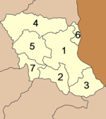 The province is subdivided into 7 districts (Amphoe
). The districts are further subdivided into 53 subdistricts (tambon
) and 493 villages (muban
).
Chaopho Chaofa Mung Mueang Shrine (ศาลเจ้าพ่อเจ้าฟ้ามุงเมือง) The shrine, which also houses the city pillar, is located on Song Nang Sathit Road in the Amphoe Mueang Municipality. For the people of Mukdahan, the shrine is considered as a sacred place of the spirit that protects the city.
Chaomae Song Nang Phi Nong Shrine (ศาลเจ้าแม่สองนางพี่น้อง) The people of Mukdahan consider this shrine another sacred place. Both the Chaomae Song Nang Phi Nong and Chaopho Chaofa Mung Mueang Shrines are twin sacred icons of the city.
Wat Si Mongkhon Tai (วัดศรีมงคลใต้) Its main ordination hall or Ubosot houses a concrete Buddha statue, which is considered a sacred item of Mukdahan.
Indochina Market (ตลาดสินค้าอินโดจีน) The market lines the Mekong River. The major shopping area is the hub of products, local and imported, as well as OTOP of Mukdahan.
Wat Si Bun Rueang - Ban Tai (วัดศรีบุญเรือง - บ้านใต้) The ordination hall houses a bronze Buddha statue called Phra Phutthasing Song, which is 1 metre wide and 1.2 metres high.
Phu Pha Thoep National Park (อุทยานแห่งชาติภูผาเทิบ) The park’s geography features undulating sandstone mountains that form the edge of the Phu Phan Range. The deciduous dipterocarp forest and mixed deciduous forest cover most part of the area, which is also the watershed of many streams; namely, Huai Ta Lueak, Huai Sing, Huai Ruea, Huai Male, Huai Chang Chon, etc. Its attractions include:
Hin Thoep Rocks (กลุ่มหินเทิบ) The formations of superimposed rocks called Hin Thoep have been eroded by rain, water, wind and sun for 120 - 95 million years.
Lan Mutchalin (ลานมุจลินท์) Next to the group of Hin Thoep is a vast rock plateau among the embrace of dwarf deciduous dipterocarp forest featuring bushes, with its uniqueness being the community of tiny plants such as Soi Suwanna, Yat Nam Khang, Nao Duean Ha, Dao Ruam Duang and Dusita.
Namtok Wang Duean Ha (น้ำตกวังเดือนห้า) The small waterfall originates from many streams that run through Lan Mutchalin.
Phu Tham Phra (ภูถ้ำพระ) The cave in this mountain houses wooden Buddha images. Nearby is a beautiful waterfall called Namtok Phu Tham Phra.
Pha Manao (ผามะนาว) The towering cliff has a waterfall that plunges below to feed the forest and wildlife. The cliff is named Pha Manao after lots of wild lime tree growing in the area.
Tham Fa Mue Daeng (ถ้ำฝ่ามือแดง) The cave houses pre-historical paintings which archaeologists assumed are probably over 5,000 years old.
Stone Age Shells (หอยสมัยหิน) The conch-like shells were found 40 feet underground in the 1 foot (0.3048 m) limestone layer at Khok Hin Daeng, Ban Na Yo, Tambon Lao Mi. It is the third place of its kind to have been found in the world, making it an interesting place for litho-tourists.
Phu Sa Dok Bua National Park (อุทยานแห่งชาติภูสระดอกบัว) Its lush forest has various types of natural beauty such as picturesque views from the mountaintop, amazing rocks, field of wild flowers in the late rainy season, and witness the mountaintop lotus which is called by the locals “mountain of lotus”.
Phu Pha Taem (ภูผาแต้ม) The cliff houses 98 paintings of hands and symbols from the pre-historical period which may be created in the same era as Tham Fa Mue Daeng in Pha Taem National Park, Amphoe Khong Chiam, Ubon Ratchathani province.
Pha Makluea (ผามะเกลือ) Situated close to Phu Pha Taem, the rock terrace under the tree’s shade and cliff offers a scenic viewpoint and rest area.
Flower Field on Phu Wat (ลานดอกไม้บนภูวัด) By the late rainy season, the vast rock terrace is beautified by various kinds of flowers such as En A, Kradum Ngoen, and Dusita. In the past, this area was used for religious rites.
Phu Pha Hom (ภูผาหอม) At an elevation of 366 metres above sea level, the picturesque viewpoint of Phu Pha Taem Range offers a panoramic view to the west.
Phu Sa Dok Bua (ภูสระดอกบัว) All pools are fascinating as they have lots of lotus of a small size. Thus, the mountain is called Phu Sa Dok Bua, literally meaning the mountain of lotus pools.
Phu Pha Taek (ภูผาแตก) Called by the military as “Hill 428”, the beautiful hill offers a picturesque view of the ranges in the Mukdahan National Park in the northern side.
Rock Terraces and Dwarf Deciduous Dipterocarp Forests (ลานหินและป่าเต็งรังแคระ) The dwarf deciduous dipterocarp forests, which can be found with grassland, are scattered around at Phu Pha Hom, at the back of Phu Pha Daeng, Phu Bok, Phu Sa Dok Bua, Phu Hua Nak, etc.
Bronze Kettledrum (กลองมโหระทึก) Kept at Wat Matchimawat (Wat Klang) close to Don Tan District Office, the one-sided bronze kettledrum is 86 cms. in diameter and 90 cms. long. The drum, which is probably more than 3,000 years old, is a collection item for the Kha and Khmer.
The Princess Mother Park - Woraphat Base (อุทยานสมเด็จย่า – ฐานวรพัฒน์)
It is Thailand’s only military base that HRH the Princess Mother and HRH Princess Galyani Vadhana spent overnight.
Wat Phu Dan Tae or Wat Phuttho Thammatharo (วัดภูด่านแต้ หรือ วัดพุทโธธัมมะธะโร) The temple houses a huge Buddha statue with a Dhammacakka - Wheel of the Doctrine - at the back, which can be noticed from a distance.
Phu Mu Forest Park (วนอุทยานภูหมู) Situated at an elevation of 353 metres above sea level, the park is a beautiful place of Mukdahan. With a mountaintop flat plain that covers some 4 km2. area, the park was once abundant with boars.
Huai Khilek Irrigation Reservoir (อ่างเก็บน้ำชลประทานห้วยขี้เหล็ก) The large reservoir with a picturesque view is a major attraction of Mukdahan.
Wat Phu Ko Cho or Wat Banphot Khiri (วัดภูก้อจ้อ หรือ วัดบรรพตคิรี) The mountaintop temple was once accommodation for Luangpu La Khemapatto, a famous monk in Vipassana mediation of Mukdahan. A bell-shape pagoda known as Khemapattachedi was built to house his ashes, with his life-like statue placed on the top floor of the building underneath the pagoda.
Namtok Tat Ton (น้ำตกตาดโตน) Situated at Ban Non Yang, the 7 metres high and 30 metres wide waterfall.
Kaeng Kabao (แก่งกะเบา) The huge rapids on the Mekong River with a large rock terrace on the bank is a favourite picnic spot for locals. In the dry season, water descents and allows islands and beaches to show off their beauty.
Wat Manophirom (วัดมโนภิรมย์) Located on the bank of the Mekong River, the ancient temple was built by artisans from Vientiane. The temple houses statues of eight Buddhas carved from black ivory and Phra-ong Saen, a sacred Buddha statue of Mukdahan.
Wat Ban Song Khon or Our Lady of the Martyrs of Thailand Shrine (วัดบ้านสองคอน - วัดศาสนาคริสต์ โรมันคาทอลิก) The huge Roman Catholic Church in a modern architectural style is named the largest and most beautiful church in Southeast Asia. The church won the Architectural Design Award 1996 from the Association of Siamese Architects under Royal Patronage.
Wat Phra Si Mahapho (วัดพระศรีมหาโพธิ์) The old “Sim” or Ubosot was built since 1916 in the folk northeastern style with beautifully carved wooden brackets supporting the roof. The murals inside feature the Vessantara Jataka
and depict Prince Damrong Rajanubhab riding a cart when he made an inspection trip in Isan.
silk, Khit
and Muk fabric, as well as produce basketry, broom, lacquer ware, etc.
Bun Duean Hok or Bun Bang Fai Festival (งานประเพณีบุญเดือนหก หรือ บุญบั้งไฟ) The celebration of the rocket festival is held annually on 10–12 May at Mu 1-3 of Amphoe Don Tan.
Boat Races (ประเพณีการแข่งเรือ) The tradition has been handed down since ancient times. It is held annually, on the 13th – 15th days of the waxing moon of the 11th lunar month, in the Mekong River to mark the end of Buddhist Lent. There are 2 major categories; namely, speed racing for small, medium and large boats. All participating boats are dug to have a round hull and will compete on a 3-km. long distance on the Mekong River. Another category is the fantasy boat contest in which the racing boats will be decorated, particularly at the figureheads.
Each year, numerous boats join the competition in both categories while people from Mukdahan and nearby provinces as well as Lao PDR. pack the venue. Boats from Savannakhet also join the races every year.
Isan
Isan is the northeastern region of Thailand. It is located on the Khorat Plateau, bordered by the Mekong River to the north and east, by Cambodia to the southeast and the Prachinburi mountains south of Nakhon Ratchasima...
provinces
Provinces of Thailand
Thailand is divided into 76 provinces , which are geographically grouped into 6 regions. The capital Bangkok is not a province but a special administrative area and is included as the 77th province since it is administered at the same level as the other 76 provinces. The name of the provinces are...
(changwat) of Thailand
Thailand
Thailand , officially the Kingdom of Thailand , formerly known as Siam , is a country located at the centre of the Indochina peninsula and Southeast Asia. It is bordered to the north by Burma and Laos, to the east by Laos and Cambodia, to the south by the Gulf of Thailand and Malaysia, and to the...
. Neighboring provinces are (from south clockwise) Amnat Charoen
Amnat Charoen Province
Amnat Charoen is one of the north-eastern provinces of Thailand. Neighboring provinces are Ubon Ratchathani, Yasothon and Mukdahan. To the east it borders Salavan of Laos.-Geography:...
, Yasothon
Yasothon Province
Yasothon is one of the provinces of Thailand, located in the North-East of Thailand on the Chi River. Neighboring provinces are Mukdahan, Amnat Charoen, Ubon Ratchathani, Sisaket and Roi Et.-Geography:...
, Roi Et
Roi Et Province
Roi Et is one of the provinces of Thailand, located in the North-East of Thailand. Neighboring Provinces are Kalasin, Mukdahan, Yasothon, Sisaket, Surin and Maha Sarakham....
, Kalasin
Kalasin Province
Kalasin is one of the provinces of Thailand, located in the North-East of Thailand. Neighboring provinces are Sakon Nakhon, Mukdahan, Roi Et, Maha Sarakham, Khon Kaen and Udon Thani.-Geography:...
, Sakon Nakhon
Sakon Nakhon Province
Sakon Nakhon is one of the north-eastern provinces of Thailand. Neighboring provinces are Nong Khai, Nakhon Phanom, Mukdahan, Kalasin and Udon Thani...
and Nakhon Phanom
Nakhon Phanom Province
Nakhon Phanom is one of the north-eastern provinces of Thailand. Neighboring provinces are Mukdahan, Sakon Nakhon and Bueng Kan. To the north-east it borders Khammouan of Laos.-Geography:...
. To the east it borders the Mekong River, across which lies Savannakhet Province of Laos
Laos
Laos Lao: ສາທາລະນະລັດ ປະຊາທິປະໄຕ ປະຊາຊົນລາວ Sathalanalat Paxathipatai Paxaxon Lao, officially the Lao People's Democratic Republic, is a landlocked country in Southeast Asia, bordered by Burma and China to the northwest, Vietnam to the east, Cambodia to the south and Thailand to the west...
.
Geography
The province is located in the MekongMekong
The Mekong is a river that runs through China, Burma, Laos, Thailand, Cambodia and Vietnam. It is the world's 10th-longest river and the 7th-longest in Asia. Its estimated length is , and it drains an area of , discharging of water annually....
valley. In the west of the province are the Phu Phan mountains
Phu Phan Mountains
The Phu Phan mountains are a range of hills dividing the Khorat Plateau of the Isan region of Thailand into two basins: the northern Sakhon Nakhon Basin, and the southern Khorat Basin.-Etymology:...
, which are covered with thick forests.
History
Lord Chandrasuriyawongse (เจ้าจันทรสุริยวงษ์) and his followers founded a settlement at Baan Luang Phonsim (บ้านหลวงโพนสิม) near the Thad Ing Hang Stupa (พระธาตุอิงฮัง) along the left banks of the Mekong River in Laos. Later, after some several decades, he died.Lord Chanthakinnaree (เจ้าจันทกินรี), his son, succeeded him as ruler. Then, in B.E.
Buddhist calendar
The Buddhist calendar is used on mainland Southeast Asia in the countries of Thailand, Cambodia, Laos, Burma and Sri Lanka in several related forms. It is a lunisolar calendar having months that are alternately 29 and 30 days, with an intercalated day and a 30-day month added at regular intervals...
2310, a huntsman crossed over the Mekong and arrived along the right side at the mouth of the stream Bang Muk (บังมุก), where he discovered a discarded realm complete with a monastery and seven sugar palm
Sugar palm
Sugar palm is a common name for several species of palms used to produce sugar.*Arenga pinnata *Borassus flabellifer*Caryota urens*Cocos nucifera...
s located on the nearby riverbank. He found the area much better than the territories along the left side of the Mekong, and moreover at the site of mouth of the Bang Muk was a huge abundance of fish. Thus, he headed back to report this to his ruler Lord Chanthakinnaree. Lord Chanthakinnaree led his followers across the Mekong to inspect the area and found that the area was indeed the remains of an ancient realm and in much better condition than any area along the left side of the Mekong. He thus led his people from Baan Luang Phonsim to establish a settlement along the right side of the Mekong at the mouth of the Bang Muk.
When he began to clear away the forests to make way for his resettlement of the realm, he found two Buddha
Gautama Buddha
Siddhārtha Gautama was a spiritual teacher from the Indian subcontinent, on whose teachings Buddhism was founded. In most Buddhist traditions, he is regarded as the Supreme Buddha Siddhārtha Gautama (Sanskrit: सिद्धार्थ गौतम; Pali: Siddhattha Gotama) was a spiritual teacher from the Indian...
images beneath a Sacred Figtree
Sacred Fig
The Sacred Fig, Ficus religiosa, or Bo-Tree , Peepal is a species of banyan fig native to India, Bangladesh, Nepal, Pakistan, Sri Lanka, southwest China and Indochina...
on the banks of the Mekong. The larger of the two was bricks-and-mortar, while the smaller one was made of fine iron. He had a new monastery built at once in the vicinity of the old, abandoned temple on the banks of the Mekong, and named it Wat Sri Moungkhoun (วัดศรีมุงคุณ) (cognate to Sri Mongkol (ศรีมงคล) in Central Thai, meaning Temple of Serene Auspices). He also constructed a palatial manse in the vicinity of the temple where he enshrined both Buddha images in vihara
Vihara
Vihara is the Sanskrit and Pali term for a Buddhist monastery. It originally meant "a secluded place in which to walk", and referred to "dwellings" or "refuges" used by wandering monks during the rainy season....
. Later, the iron Buddha image (the smaller one) appeared to mysteriously reestablish itself beneath the figtree where it had first been discovered and ultimately, after some three or four spectacles of this nature, began slowly sinking into the ground there until only the crown of the head could be seen. Thus, an alternate place of worship was built there to cover the site instead and the image itself was then named Phra Loup Lek (พระหลุบเหล็ก), or Venerable One of Ironmetal Who Shrouds Himself. Nowadays the site where Phra Loup Lek would submerge himself beneath the earth has been overtaken by the waters of the Mekong and washed away (presumably leaving only the shrine rescued and preserved at the front of the vihara at today’s Wat Sri Mongkol South (วัดศรีมงคลใต้)).
As for the mason-and-mortar Buddha image enshrined in the vihara at the Sri Mongkol Temple, the inhabitants of the realm named it Phra Chao Ong Luang (พระเจ้าองค์หลวง), or Venerable Holy One, and made it the representative image of Wat Sri Mongkol, which itself was later renamed to Wat Sri Mongkol South; this Buddha image has been associated with the settlement and realm ever since.
During the rebuilding of the realm at around midnight were reports of a transparent or translucent object glittering and bright spotted emerging from the seven sugar palms on the banks of the Mekong River; it drifted in the air above the Mekong every night until near dawn when the crystal-like object would then float back into the seven trees from whence it came. Lord Chanthakinnaree named this auspicious omen Keo Mukdahan (แก้วมุกดาหาร) or the Pearlsmouth Crystal as he had founded his realm on the banks of the Mekong right where the mouth of the stream Bang Muk (or Pearlhaven) was located, in which people had discovered pearls (muk; มุก) in clams there. However, it is important to note that mukdahan can refer to most any semiprecious stone resembling the pearl having a grey dull color, and not necessarily the pearl oyster, Meleagrina margaritifera. Lord Chanthakinnaree then also renamed the realm to Mueang
Mueang
Mueang were historical semi-independent city-states or principalities in present-day Thailand, Laos, parts of northern Vietnam and the Shan State of Myanmar. Smaller Mueang were subordinate to more powerful neighboring Mueang, which in turn were subordinate to the central king, as described in...
Mukdahan, as from the Fourth Month of the Year of the Pig
Pig (zodiac)
The Pig , is the last of the 12 animals which appear in the Chinese zodiac. The Year of the Pig is associated with the earthly branch Hai .In Chinese culture, the pig is associated with fertility and virility...
, Year 1132 of the Chulasakarat (Minor Era), [Year 2313 of the Buddhasakarat (Buddhist Era or BE)] of the Buddhist calendar
Buddhist calendar
The Buddhist calendar is used on mainland Southeast Asia in the countries of Thailand, Cambodia, Laos, Burma and Sri Lanka in several related forms. It is a lunisolar calendar having months that are alternately 29 and 30 days, with an intercalated day and a 30-day month added at regular intervals...
. The realm of Mukdahan at this stage covered both sides of the Mekong and reached the frontierlands of the Vietnamese
Vietnamese people
The Vietnamese people are an ethnic group originating from present-day northern Vietnam and southern China. They are the majority ethnic group of Vietnam, comprising 86% of the population as of the 1999 census, and are officially known as Kinh to distinguish them from other ethnic groups in Vietnam...
(including the Laotian province of Savannakhet).
In B.E.2321, during the Thonburi Period when King Taksin the Great
Taksin
Taksin ; was the only King of the Thonburi Kingdom...
extended his armed forces up into the area of the Mekong River, he ordered Phra Mahakasut Suek and Chao Phya Chakri to dispatch their troops along the banks of the Mekong in order to suppress and unify the lords of all the realms great and small there on both sides of the Mekong together under the reign of the Kingdom of Thonburi
Thonburi
Thon Buri is an area of modern Bangkok. It was capital of Thailand from 1767 to 1782, during the reign of King Taksin, after the previous capital Ayutthaya was sacked by the Burmese. It is located on the opposite bank of Chao Phraya River to Bangkok...
, declaring Lord Chanthakinnaree the Phya Chanthasrisuraja Uparaja
Uparaja
Uparaja or Ouparath, also Ouparaja , was a royal title reserved for the vice royal in the Buddhist dynasties in Burma, Cambodia, and Laos and Thailand as well as some of their minor tributary kingdoms.-Burma:...
Mandhaturaj (พระยาจันทรศรีสุราชอุปราชามันธาตุราช), the first Lord of the Realm of Mukdahan and thereby officially named the realm Mueang Mukdahan.
The city of Mukdahan was founded in 1770 by Lord Chanthakinnaree of Phonsim. It was originally administrated from Udon Thani
Udon Thani
Udon Thani is a city in Isan, north-east Thailand, and the capital of Udon Thani Province.-Location:The province of Udon Thani has a population of 1,467.200, the city alone 500.000. Geographical location and is approximately 560 km from Bangkok...
, but in 1907 it became a district (amphoe) of Nakhon Phanom Province
Nakhon Phanom Province
Nakhon Phanom is one of the north-eastern provinces of Thailand. Neighboring provinces are Mukdahan, Sakon Nakhon and Bueng Kan. To the north-east it borders Khammouan of Laos.-Geography:...
. On September 27, 1982 Mukdahan was upgraded to province status.
In 2006, the Second Thai-Lao Friendship Bridge from Mukdahan to Savannakhet, Laos was opened.
Climate
Symbols
The provincial sealSeals of The Provinces of Thailand
-Present-day provinces of Thailand:This list includes all the seals of the Provinces of Thailand. It also includes the special administrative area of the capital, Bangkok.-Former Provinces:-External links:*...
shows the Prasart Song Nang Sathit palace, in which an opal
Opal
Opal is an amorphous form of silica related to quartz, a mineraloid form, not a mineral. 3% to 21% of the total weight is water, but the content is usually between 6% to 10%. It is deposited at a relatively low temperature and may occur in the fissures of almost any kind of rock, being most...
is displayed on a tray
Phan (tray)
Phan is an artistically decorated tray with a pedestal common in Thailand, Cambodia and Laos.-Description:A phan is normally round and comes in different sizes. The usual measures range between a diameter of 20 cm to about 50 cm. It is more or less deep....
.
Provincial tree and flower is Ochna integerrima
Ochna integerrima
Ochna integerrima , is a tree species of the family Ochnaceae. The spectacular yellow flowers of this plant make it very popular in southern Vietnam, where the plant is purchased during Tết, the traditional Vietnamese New Year...
.
The provincial slogan is Skyscraping Ho Kaeo Tower, Phu Pha Thoep and Kaeng Kabao, Eight Ethnic Minorities, Famous Sweet Tamarind, Large Ancient Kettledrum, Origin of Lam Phaya, Stunning View of the Mekong River, Gateway to Indochina.
Administrative divisions
Amphoe
An amphoe is the second level administrative subdivision of Thailand. Usually translated as district, amphoe make up the provinces, and are analogous to a county seat...
). The districts are further subdivided into 53 subdistricts (tambon
Tambon
Tambon is a local government unit in Thailand. Below district and province , they form the third administrative subdivision level. As of the 2009 there are 7255 tambon, not including the 169 khwaeng of Bangkok, which are set at the same administrative level, thus every district contains 8-10 tambon...
) and 493 villages (muban
Muban
Muban is the lowest administrative subdivision of Thailand. Usually translated as village, they are the subdivision of tambon. As of 2008, there are 74944 administrative villages in Thailand. As of the 1990 census, the average village consisted of 144 households or 746 persons.A muban does not...
).
|
|
Sights
Ho Kaeo Mukdahan Chaloem Phra Kiat Kanchanaphisek (หอแก้วมุกดาหารเฉลิมพระเกียรติกาญจนาภิเษก) The tower was built to commemorate the 50th Anniversary of His Majesty’s Accession to the Throne. The topmost sphere houses a Buddha image “Phra Nawa Ming Mongkhon Mukdahan” and 7 Buddha statues in 7 different attitudes for each day of the week.Chaopho Chaofa Mung Mueang Shrine (ศาลเจ้าพ่อเจ้าฟ้ามุงเมือง) The shrine, which also houses the city pillar, is located on Song Nang Sathit Road in the Amphoe Mueang Municipality. For the people of Mukdahan, the shrine is considered as a sacred place of the spirit that protects the city.
Chaomae Song Nang Phi Nong Shrine (ศาลเจ้าแม่สองนางพี่น้อง) The people of Mukdahan consider this shrine another sacred place. Both the Chaomae Song Nang Phi Nong and Chaopho Chaofa Mung Mueang Shrines are twin sacred icons of the city.
Wat Si Mongkhon Tai (วัดศรีมงคลใต้) Its main ordination hall or Ubosot houses a concrete Buddha statue, which is considered a sacred item of Mukdahan.
Indochina Market (ตลาดสินค้าอินโดจีน) The market lines the Mekong River. The major shopping area is the hub of products, local and imported, as well as OTOP of Mukdahan.
Wat Si Bun Rueang - Ban Tai (วัดศรีบุญเรือง - บ้านใต้) The ordination hall houses a bronze Buddha statue called Phra Phutthasing Song, which is 1 metre wide and 1.2 metres high.
Phu Pha Thoep National Park (อุทยานแห่งชาติภูผาเทิบ) The park’s geography features undulating sandstone mountains that form the edge of the Phu Phan Range. The deciduous dipterocarp forest and mixed deciduous forest cover most part of the area, which is also the watershed of many streams; namely, Huai Ta Lueak, Huai Sing, Huai Ruea, Huai Male, Huai Chang Chon, etc. Its attractions include:
Hin Thoep Rocks (กลุ่มหินเทิบ) The formations of superimposed rocks called Hin Thoep have been eroded by rain, water, wind and sun for 120 - 95 million years.
Lan Mutchalin (ลานมุจลินท์) Next to the group of Hin Thoep is a vast rock plateau among the embrace of dwarf deciduous dipterocarp forest featuring bushes, with its uniqueness being the community of tiny plants such as Soi Suwanna, Yat Nam Khang, Nao Duean Ha, Dao Ruam Duang and Dusita.
Namtok Wang Duean Ha (น้ำตกวังเดือนห้า) The small waterfall originates from many streams that run through Lan Mutchalin.
Phu Tham Phra (ภูถ้ำพระ) The cave in this mountain houses wooden Buddha images. Nearby is a beautiful waterfall called Namtok Phu Tham Phra.
Pha Manao (ผามะนาว) The towering cliff has a waterfall that plunges below to feed the forest and wildlife. The cliff is named Pha Manao after lots of wild lime tree growing in the area.
Tham Fa Mue Daeng (ถ้ำฝ่ามือแดง) The cave houses pre-historical paintings which archaeologists assumed are probably over 5,000 years old.
Stone Age Shells (หอยสมัยหิน) The conch-like shells were found 40 feet underground in the 1 foot (0.3048 m) limestone layer at Khok Hin Daeng, Ban Na Yo, Tambon Lao Mi. It is the third place of its kind to have been found in the world, making it an interesting place for litho-tourists.
Phu Sa Dok Bua National Park (อุทยานแห่งชาติภูสระดอกบัว) Its lush forest has various types of natural beauty such as picturesque views from the mountaintop, amazing rocks, field of wild flowers in the late rainy season, and witness the mountaintop lotus which is called by the locals “mountain of lotus”.
Phu Pha Taem (ภูผาแต้ม) The cliff houses 98 paintings of hands and symbols from the pre-historical period which may be created in the same era as Tham Fa Mue Daeng in Pha Taem National Park, Amphoe Khong Chiam, Ubon Ratchathani province.
Pha Makluea (ผามะเกลือ) Situated close to Phu Pha Taem, the rock terrace under the tree’s shade and cliff offers a scenic viewpoint and rest area.
Flower Field on Phu Wat (ลานดอกไม้บนภูวัด) By the late rainy season, the vast rock terrace is beautified by various kinds of flowers such as En A, Kradum Ngoen, and Dusita. In the past, this area was used for religious rites.
Phu Pha Hom (ภูผาหอม) At an elevation of 366 metres above sea level, the picturesque viewpoint of Phu Pha Taem Range offers a panoramic view to the west.
Phu Sa Dok Bua (ภูสระดอกบัว) All pools are fascinating as they have lots of lotus of a small size. Thus, the mountain is called Phu Sa Dok Bua, literally meaning the mountain of lotus pools.
Phu Pha Taek (ภูผาแตก) Called by the military as “Hill 428”, the beautiful hill offers a picturesque view of the ranges in the Mukdahan National Park in the northern side.
Rock Terraces and Dwarf Deciduous Dipterocarp Forests (ลานหินและป่าเต็งรังแคระ) The dwarf deciduous dipterocarp forests, which can be found with grassland, are scattered around at Phu Pha Hom, at the back of Phu Pha Daeng, Phu Bok, Phu Sa Dok Bua, Phu Hua Nak, etc.
Bronze Kettledrum (กลองมโหระทึก) Kept at Wat Matchimawat (Wat Klang) close to Don Tan District Office, the one-sided bronze kettledrum is 86 cms. in diameter and 90 cms. long. The drum, which is probably more than 3,000 years old, is a collection item for the Kha and Khmer.
The Princess Mother Park - Woraphat Base (อุทยานสมเด็จย่า – ฐานวรพัฒน์)
It is Thailand’s only military base that HRH the Princess Mother and HRH Princess Galyani Vadhana spent overnight.
Wat Phu Dan Tae or Wat Phuttho Thammatharo (วัดภูด่านแต้ หรือ วัดพุทโธธัมมะธะโร) The temple houses a huge Buddha statue with a Dhammacakka - Wheel of the Doctrine - at the back, which can be noticed from a distance.
Phu Mu Forest Park (วนอุทยานภูหมู) Situated at an elevation of 353 metres above sea level, the park is a beautiful place of Mukdahan. With a mountaintop flat plain that covers some 4 km2. area, the park was once abundant with boars.
Huai Khilek Irrigation Reservoir (อ่างเก็บน้ำชลประทานห้วยขี้เหล็ก) The large reservoir with a picturesque view is a major attraction of Mukdahan.
Wat Phu Ko Cho or Wat Banphot Khiri (วัดภูก้อจ้อ หรือ วัดบรรพตคิรี) The mountaintop temple was once accommodation for Luangpu La Khemapatto, a famous monk in Vipassana mediation of Mukdahan. A bell-shape pagoda known as Khemapattachedi was built to house his ashes, with his life-like statue placed on the top floor of the building underneath the pagoda.
Namtok Tat Ton (น้ำตกตาดโตน) Situated at Ban Non Yang, the 7 metres high and 30 metres wide waterfall.
Kaeng Kabao (แก่งกะเบา) The huge rapids on the Mekong River with a large rock terrace on the bank is a favourite picnic spot for locals. In the dry season, water descents and allows islands and beaches to show off their beauty.
Wat Manophirom (วัดมโนภิรมย์) Located on the bank of the Mekong River, the ancient temple was built by artisans from Vientiane. The temple houses statues of eight Buddhas carved from black ivory and Phra-ong Saen, a sacred Buddha statue of Mukdahan.
Wat Ban Song Khon or Our Lady of the Martyrs of Thailand Shrine (วัดบ้านสองคอน - วัดศาสนาคริสต์ โรมันคาทอลิก) The huge Roman Catholic Church in a modern architectural style is named the largest and most beautiful church in Southeast Asia. The church won the Architectural Design Award 1996 from the Association of Siamese Architects under Royal Patronage.
Wat Phra Si Mahapho (วัดพระศรีมหาโพธิ์) The old “Sim” or Ubosot was built since 1916 in the folk northeastern style with beautifully carved wooden brackets supporting the roof. The murals inside feature the Vessantara Jataka
Vessantara Jataka
The Vessantara Jataka is one of the most popular avadānas of Theravada Buddhism. The Vessantara Jataka tells the story of one of Buddha's past lives, about a compassionate prince, Vessantara, who gives away everything he owns, including his children, thereby displaying the virtue of perfect charity...
and depict Prince Damrong Rajanubhab riding a cart when he made an inspection trip in Isan.
Local Products
Most local products are made in Amphoe Nong Sung and Khamcha-i where housewife groups weave excellent local textiles such as silk, tied and dyed MudmeeIkat
Ikat, or Ikkat, is a dyeing technique used to pattern textiles that employs a resist dyeing process similar to tie-dye on either the warp or weft fibres....
silk, Khit
Khit
Khit, or Khid, is an ancient type of woven cloth produced in certain areas of Isaan, the northeastern region of Thailand.-Tradition:Khit weaving is done by hand in traditional looms. It favours certain basic colors, like red, purple and dark green, although other colors are also used...
and Muk fabric, as well as produce basketry, broom, lacquer ware, etc.
Festivals
Mukdahan Red Cross Fair (งานกาชาดจังหวัดมุกดาหาร) Held annually between 9–17 January in front of the city hall, the fair includes exhibitions, outlets of state departments.Bun Duean Hok or Bun Bang Fai Festival (งานประเพณีบุญเดือนหก หรือ บุญบั้งไฟ) The celebration of the rocket festival is held annually on 10–12 May at Mu 1-3 of Amphoe Don Tan.
Boat Races (ประเพณีการแข่งเรือ) The tradition has been handed down since ancient times. It is held annually, on the 13th – 15th days of the waxing moon of the 11th lunar month, in the Mekong River to mark the end of Buddhist Lent. There are 2 major categories; namely, speed racing for small, medium and large boats. All participating boats are dug to have a round hull and will compete on a 3-km. long distance on the Mekong River. Another category is the fantasy boat contest in which the racing boats will be decorated, particularly at the figureheads.
Each year, numerous boats join the competition in both categories while people from Mukdahan and nearby provinces as well as Lao PDR. pack the venue. Boats from Savannakhet also join the races every year.