

Roddon
Encyclopedia
Watercourse
A watercourse is any flowing body of water. These include rivers, streams, anabranches, and so forth.-See also:* physical geography* Environmental flow* Waterway* Hydrology* Wadi-External links:...
such as a river or tidal-creek, especially in the Fen district
Fenland
Fenland is a local government district in Cambridgeshire, England. Its council is based in March, and covers the neighbouring market towns of Chatteris, Whittlesey, and Wisbech, often called the "capital of the fens"...
of East Anglia
East Anglia
East Anglia is a traditional name for a region of eastern England, named after an ancient Anglo-Saxon kingdom, the Kingdom of the East Angles. The Angles took their name from their homeland Angeln, in northern Germany. East Anglia initially consisted of Norfolk and Suffolk, but upon the marriage of...
in England. Such raised silt
Silt
Silt is granular material of a size somewhere between sand and clay whose mineral origin is quartz and feldspar. Silt may occur as a soil or as suspended sediment in a surface water body...
and clay-filled beds are ideal for settlement in the less firm peat
Peat
Peat is an accumulation of partially decayed vegetation matter or histosol. Peat forms in wetland bogs, moors, muskegs, pocosins, mires, and peat swamp forests. Peat is harvested as an important source of fuel in certain parts of the world...
of The Fens
The Fens
The Fens, also known as the , are a naturally marshy region in eastern England. Most of the fens were drained several centuries ago, resulting in a flat, damp, low-lying agricultural region....
. Many writers have followed the archaeologist Major Gordon Fowler's preference for the word roddon to define such structures though modern researchers suggest the word rodham is the more correct local word.
Oak preserved in peat through which roddons passed have been dated to around 4000 years before present (BP
Before Present
Before Present years is a time scale used in archaeology, geology, and other scientific disciplines to specify when events in the past occurred. Because the "present" time changes, standard practice is to use AD 1950 as the origin of the age scale, reflecting the fact that radiocarbon...
). The origin of the raised nature of a roddon is debated; some writers suggest this is due to a silt build-up during marine incursion. Another explanation (and the one most favoured today) is based on the greater shrinkage of peat, compared to that of silt. This theory suggests that the surrounding peat lands have subsided more than the silt-filled banks of the roddon, leaving the banks raised above the general level of the area.
Etymology
The term roddon may be a corruption of the now rare rodham, which meant "near a river where osiers grow", with particular reference to the River ThamesRiver Thames
The River Thames flows through southern England. It is the longest river entirely in England and the second longest in the United Kingdom. While it is best known because its lower reaches flow through central London, the river flows alongside several other towns and cities, including Oxford,...
; an osier is a willow used in basket-making.
Archaeologist Bob Silvester suggests that the term roddon is more popular among local writers such as Fowler (1932), Darby (1940), Phillips (1970), and Godwin (1978), though rodham is acknowledged by Godwin. Silvester notes that Astbury (1958) and e.g. Seale (1975) Soil survey of Cambridgeshire preferred the term rodham. Roddam is used by Egar (1897) and also by Skertchly (1877); in Skertchly's case, as a local term "used only in the Isle of Ely
Isle of Ely
The Isle of Ely is a historic region around the city of Ely now in Cambridgeshire, England but previously a county in its own right.-Etymology:...
". The Oxford English Dictionary
Oxford English Dictionary
The Oxford English Dictionary , published by the Oxford University Press, is the self-styled premier dictionary of the English language. Two fully bound print editions of the OED have been published under its current name, in 1928 and 1989. The first edition was published in twelve volumes , and...
quotes an even earlier written source of roddam as Wright (1857). Toponymist Richard Coates (2005) agrees that whilst roddon is now the normal geographical term, the older form, –(h)am, rejected by Fowler, was in fact the correct local term, and writers who followed Fowler are wrong. Astbury goes further, quoting Clarke (1852) discussing "veins of silt" as silted-up creeks which Astbury claims are rodhams, though Clarke does not use that term.
Journalist A K Astbury (1987) also examines the word roddin, which means a rough path or a track trodden by sheep. He says that in north Lincolnshire
Lincolnshire
Lincolnshire is a county in the east of England. It borders Norfolk to the south east, Cambridgeshire to the south, Rutland to the south west, Leicestershire and Nottinghamshire to the west, South Yorkshire to the north west, and the East Riding of Yorkshire to the north. It also borders...
, a roading is a private and little-used road. Astbury agrees that later writers have adopted Fowler's spelling though he still maintains that fenmen call such silted-up old river beds rodhams. None of the different spelling variations of roddon is found in Robert Forby's The Vocabulary of East Anglia.
Formation
Carbon dating of oakBog oak
Bog-wood, also known as morta is wood from trees that have been buried in peat bogs and preserved from decay by the acidic and anaerobic bog conditions, sometimes for hundreds or even thousands of years. The wood is usually stained brown by tannins dissolved in the acidic water...
found in the fen edge
Fen Edge
Fen Edge is an area and collection of villages in the South Cambridgeshire district of Cambridgeshire, England. The five villages in Fen Edge are Cottenham, Landbeach, Rampton, Waterbeach and Willingham...
peat of Adventurers Fen near Wicken
Wicken Fen
Wicken Fen is a wetland nature reserve situated near the village of Wicken, Cambridgeshire, England.It is one of Britain's oldest nature reserves, and was the first reserve acquired by the National Trust, in 1899. The reserve includes fenland, farmland, marsh, and reedbeds...
, almost 57 kilometres (35.4 mi) from the nearest present-day coast at Kings Lynn, suggests the peat in this area was formed by a large marine incursion in about 2400 BC. The Nordelph peat, which covers a large area of fenland, including most of the Ely district, began forming around 4000 BP
Before Present
Before Present years is a time scale used in archaeology, geology, and other scientific disciplines to specify when events in the past occurred. Because the "present" time changes, standard practice is to use AD 1950 as the origin of the age scale, reflecting the fact that radiocarbon...
. Sampling of roddons in the area has confirmed that they were formed from the mid– to late–Holocene
Holocene
The Holocene is a geological epoch which began at the end of the Pleistocene and continues to the present. The Holocene is part of the Quaternary period. Its name comes from the Greek words and , meaning "entirely recent"...
age — 6000–2000 BP. The raised and layered banks of silt in a roddon contain mostly estuarine
Estuary
An estuary is a partly enclosed coastal body of water with one or more rivers or streams flowing into it, and with a free connection to the open sea....
foraminifera
Foraminifera
The Foraminifera , or forams for short, are a large group of amoeboid protists which are among the commonest plankton species. They have reticulating pseudopods, fine strands of cytoplasm that branch and merge to form a dynamic net...
and ostracod
Ostracod
Ostracoda is a class of the Crustacea, sometimes known as the seed shrimp because of their appearance. Some 65,000 species have been identified, grouped into several orders....
s which suggests that the silt was deposited through tidal processes.
The raised nature of the roddon is debated. The archaeologist Major Gordon Fowler explained these are due to the extensive drainage of the fens, and "differential shrinkage" of the silt bed and the surrounding peat. Harry Godwin noted that near the Holme Fen post the peat surface stood 1.8 metres (5.9 ft) above ordnance datum
Ordnance Datum
In the British Isles, an Ordnance Datum or OD is a vertical datum used by an ordnance survey as the basis for deriving altitudes on maps. A spot height may be expressed as AOD for "above ordnance datum". Usually mean sea level is used for the datum...
(OD) in 1848 with the clay of the fen floor about 5.5 metres (18 ft) below OD. In 1957 Godwin reported the peat surface at the same post 2.5 metres (8.2 ft) below OD — a shrinkage of 4.3 metres (14.1 ft) in 109 years. The peat is now 2.75 metres (9 ft) below OD in the area. The cause of the shrinking is due to a combination of drying out, trench cutting for peat-fuel, biological oxidation and surface burning associated with arable farming.
Godwin suggests that roddons were formed in the Romano-British
Romano-British
Romano-British culture describes the culture that arose in Britain under the Roman Empire following the Roman conquest of AD 43 and the creation of the province of Britannia. It arose as a fusion of the imported Roman culture with that of the indigenous Britons, a people of Celtic language and...
age (AD 43–500) during a second and less severe marine incursion, which left extensive silt deposits on the seaward parts of the fens and "silt deposition up the main rivers", forming raised banks or levees. Dinah Smith agrees with Fowler, suggesting that the raised nature of the silt banks are due to the "subsidence" of the surrounding area, mainly caused by human activity, such as agriculture and drainage. These have permanently changed the environment, and future marine incursions may not have the same effects as historical ones.
Settlements
In recounting the building practices of the local area, Astbury notes that major structures such as the monasteries at ElyEly, Cambridgeshire
Ely is a cathedral city in Cambridgeshire, England, 14 miles north-northeast of Cambridge and about by road from London. It is built on a Lower Greensand island, which at a maximum elevation of is the highest land in the Fens...
, Thorney
Thorney, Cambridgeshire
Thorney is a village about 8 miles east of Peterborough in the City of Peterborough unitary authority, England, on the A47. Historically it was part of the Isle of Ely, which was considered part of Cambridgeshire but was transferred into the former county of Huntingdon and Peterborough and...
and Crowland
Crowland
Crowland or Croyland is a small town in south Lincolnshire, England, positioned between Peterborough and Spalding, with two sites of historical interest.-Geography:...
were built on islands or ridges. These structures rest on Cretaceous
Cretaceous
The Cretaceous , derived from the Latin "creta" , usually abbreviated K for its German translation Kreide , is a geologic period and system from circa to million years ago. In the geologic timescale, the Cretaceous follows the Jurassic period and is followed by the Paleogene period of the...
Lower Greensand which overlie Jurassic
Jurassic
The Jurassic is a geologic period and system that extends from about Mya to Mya, that is, from the end of the Triassic to the beginning of the Cretaceous. The Jurassic constitutes the middle period of the Mesozoic era, also known as the age of reptiles. The start of the period is marked by...
period Kimmeridge
Kimmeridge Clay
The Kimmeridge Clay Formation is a sedimentary deposit of fossiliferous marine clay which is of Jurassic age. It occurs in Europe.Kimmeridge Clay is arguably the most economically important unit of rocks in the whole of Europe, being the major source rock for oil fields in the North Sea hydrocarbon...
on top of Jurassic period Ampthill
Ampthill Clay
The Ampthill Clay is a Mesozoic geologic formation. Dinosaur remains diagnostic to the genus level are among the fossils that have been recovered from the formation.-See also:* List of dinosaur-bearing rock formations...
clay
Clay
Clay is a general term including many combinations of one or more clay minerals with traces of metal oxides and organic matter. Geologic clay deposits are mostly composed of phyllosilicate minerals containing variable amounts of water trapped in the mineral structure.- Formation :Clay minerals...
s. For example, the village of Little Thetford
Little Thetford
Little Thetford is a small village and civil parish south of Ely in Cambridgeshire, England, about by road from London. The village is built on a boulder clay island surrounded by flat fenland countryside, typical of settlements in this part of the East of England...
, 5 kilometres (3 mi) south of Ely, lies at about 5 metres (16.4 ft) above sea-level, and sits largely on an island of Kimmeridge Clay, a Jurassic shallow-water
Waves and shallow water
When waves travel into areas of shallow water, they begin to be affected by the ocean bottom. The free orbital motion of the water is disrupted, and water particles in orbital motion no longer return to their original position. As the water becomes shallower, the swell becomes higher and steeper,...
shelf-sea
Continental shelf
The continental shelf is the extended perimeter of each continent and associated coastal plain. Much of the shelf was exposed during glacial periods, but is now submerged under relatively shallow seas and gulfs, and was similarly submerged during other interglacial periods. The continental margin,...
deposit
Deposition (geology)
Deposition is the geological process by which material is added to a landform or land mass. Fluids such as wind and water, as well as sediment flowing via gravity, transport previously eroded sediment, which, at the loss of enough kinetic energy in the fluid, is deposited, building up layers of...
. Underlying the Kimmeridge Clay are older Jurassic clays, which also contain thin beds of limestone
Limestone
Limestone is a sedimentary rock composed largely of the minerals calcite and aragonite, which are different crystal forms of calcium carbonate . Many limestones are composed from skeletal fragments of marine organisms such as coral or foraminifera....
and sandstone
Sandstone
Sandstone is a sedimentary rock composed mainly of sand-sized minerals or rock grains.Most sandstone is composed of quartz and/or feldspar because these are the most common minerals in the Earth's crust. Like sand, sandstone may be any colour, but the most common colours are tan, brown, yellow,...
.
Buildings can and have been erected on peat although it is a poor founding material. Older houses, in the area of Burnt Fen near Littleport, Cambridgeshire
Littleport, Cambridgeshire
Littleport is the largest village in East Cambridgeshire, England, approximately north of Ely and south-east of Welney. It lies on the Bedford Level South section of the River Great Ouse, close to Burnt Fen and Mare Fen...
, were built on peat whilst more modern buildings in the same area are built on concrete raft foundations floating on the peat.
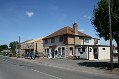
In contrast, Benwick
Benwick
Benwick is a village and civil parish in the Fenland district of Cambridgeshire, England. It is approximately from Peterborough and from Cambridge...
, 22 kilometres (13.7 mi) north-west of Ely, is an example of a settlement built on a roddon of the old West Water. "Once described as the 'only village on the peat, Benwick's High Street is built on a roddon. The roddon that was the course of the River Great Ouse
River Great Ouse
The Great Ouse is a river in the east of England. At long, it is the fourth-longest river in the United Kingdom. The river has been important for navigation, and for draining the low-lying region through which it flows. Its course has been modified several times, with the first recorded being in...
forms a base for the very small hamlet of Prickwillow
Prickwillow
Originally a small hamlet on the banks of the River Great Ouse, but now on the banks of the River Lark since re-organisation of the river system, the village of Prickwillow has an estimated mid-2005 population of 440...
, 6 kilometres (3.7 mi) north-east of Ely. Wisbech St Mary
Wisbech St Mary
Wisbech St Mary is a small village, west of the town of Wisbech in Cambridgeshire, England.and lies between two roads, the B1169 and the A47.The village has a church, a primary school and some public houses....
, a small village 3 kilometres (1.9 mi) west of Wisbech
Wisbech
Wisbech is a market town, inland port and civil parish with a population of 20,200 in the Fens of Cambridgeshire. The tidal River Nene runs through the centre of the town and is spanned by two bridges...
is built on a roddon. Spaindelf Farm is built on the dried out bed of the Little Ouse.
A roddon noted by Fowler in 1932 at Rodham Farm, 4 kilometres (2.5 mi) north-east of March, Cambridgeshire
March, Cambridgeshire
March is a Fenland market town and civil parish in the Isle of Ely area of Cambridgeshire, England. March was the county town of the Isle of Ely, a separate administrative county between 1889 and 1965, and is now the administrative centre of Fenland District Council.The town was an important...
was exposed in a pit just east of the farm cottage. At that time, this roddon was 2.45 metres (8 ft) above the nearby peat and was 64 metres (70 yd) wide on its curved surface. It was once thought to be an ancient gravel track. Piles need to be used on the sides of dykes which cut through large roddons to prevent the silt of the roddon collapsing into the dyke.