
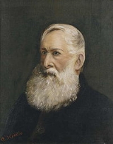
Robert Hoddle
Encyclopedia


Port Phillip
Port Phillip Port Phillip Port Phillip (also commonly referred to as Port Phillip Bay or (locally) just The Bay, is a large bay in southern Victoria, Australia; it is the location of Melbourne. Geographically, the bay covers and the shore stretches roughly . Although it is extremely shallow for...
in the 1830s, and the creator of the Hoddle Grid
Hoddle Grid
The Hoddle Grid is the layout of the streets in the centre of the central business district of Melbourne. Named after its designer, Robert Hoddle, the Grid was laid out in 1837, and later extended...
, the street grid system upon which inner city Melbourne is based. He was also an accomplished artist and depicted scenes of the Port Philip region as well as New South Wales. Hoddle was one of the earliest-known European artists to capture images of Ginninderra
Ginninderra
Ginninderra is the name of the former agricultural lands surrendered to urban development on the western and north-western fringes of Canberra, Australia's National Capital...
, an area now occupied by Canberra, Australia's National Capital. Hoddle, the son of a bank clerk for the Bank of England
Bank of England
The Bank of England is the central bank of the United Kingdom and the model on which most modern central banks have been based. Established in 1694, it is the second oldest central bank in the world...
, was born in Westminster
Westminster
Westminster is an area of central London, within the City of Westminster, England. It lies on the north bank of the River Thames, southwest of the City of London and southwest of Charing Cross...
, London
London
London is the capital city of :England and the :United Kingdom, the largest metropolitan area in the United Kingdom, and the largest urban zone in the European Union by most measures. Located on the River Thames, London has been a major settlement for two millennia, its history going back to its...
.
Surveying in Australia
Robert Hoddle trained as a cadet surveyor in the Royal military surveyors beginning in 1812. He sailed for the Cape ColonyCape Colony
The Cape Colony, part of modern South Africa, was established by the Dutch East India Company in 1652, with the founding of Cape Town. It was subsequently occupied by the British in 1795 when the Netherlands were occupied by revolutionary France, so that the French revolutionaries could not take...
, South Africa in 1822 where he worked on military surveys. Ten years on he migrated to the Australian colonies, arriving in Sydney
Sydney
Sydney is the most populous city in Australia and the state capital of New South Wales. Sydney is located on Australia's south-east coast of the Tasman Sea. As of June 2010, the greater metropolitan area had an approximate population of 4.6 million people...
aboard the William Penn in July 1823. Governor Brisbane
Thomas Brisbane
Major-General Sir Thomas Makdougall Brisbane, 1st Baronet GCH, GCB, FRS, FRSE was a British soldier, colonial Governor and astronomer.-Early life:...
appointed him assistant surveyor under surveyor-general John Oxley
John Oxley
John Joseph William Molesworth Oxley was an explorer and surveyor of Australia in the early period of English colonisation.October 1802 he was engaged in coastal survey work including an expedition to Western Port in 1804-05...
. He spent the next twelve years in Queensland
Queensland
Queensland is a state of Australia, occupying the north-eastern section of the mainland continent. It is bordered by the Northern Territory, South Australia and New South Wales to the west, south-west and south respectively. To the east, Queensland is bordered by the Coral Sea and Pacific Ocean...
and later still in NSW where he surveyed the sites for the New South Wales
New South Wales
New South Wales is a state of :Australia, located in the east of the country. It is bordered by Queensland, Victoria and South Australia to the north, south and west respectively. To the east, the state is bordered by the Tasman Sea, which forms part of the Pacific Ocean. New South Wales...
towns of Berrima
Berrima, New South Wales
Berrima is an historic village in the Southern Highlands of New South Wales, Australia, in Wingecarribee Shire. The village, once a major town, is located on the Old Hume Highway between Canberra and Sydney. It was previously known officially as the Town of Berrima...
and Goulburn
Goulburn, New South Wales
Goulburn is a provincial city in the Southern Tablelands of New South Wales, Australia in Goulburn Mulwaree Council Local Government Area. It is located south-west of Sydney on the Hume Highway and above sea-level. On Census night 2006, Goulburn had a population of 20,127 people...
as well as Bell's Line of Road
Bell's Line of Road
The Bells Line of Road is a major road in New South Wales and runs from North Richmond on the North-Western outskirts of Sydney to Bell in the Blue Mountains, where it becomes Chifley Road....
in the Blue Mountains. Between 1830 and 1836, Hoddle made several visits to the rural district now occupied by the Australian Capital Territory
Australian Capital Territory
The Australian Capital Territory, often abbreviated ACT, is the capital territory of the Commonwealth of Australia and is the smallest self-governing internal territory...
(A.C.T.), where he surveyed property boundaries. Squatters were urgently pressing for government surveyors to legalise their rural holdings. Hoddle’s field book indexes the history of the aforementioned areas and pastoralists— George Palmer, Robert Campbell
Robert Campbell (1769–1846)
Robert Campbell was a pioneering and leading merchant in Sydney, a land-owner, a pastoralist, a philanthropist, and a politician being a member of the first New South Wales Legislative Council...
and Hamilton Hume
Hamilton Hume
Hamilton Hume was the first Australian born explorer. Along with Hovell in 1824, Hume was part of an expedition that first took an overland route from Sydney to Port Phillip near the site of present day Melbourne...
.
Hoddle arrived in Port Phillip the future site for Melbourne, in March 1837 and was appointed senior surveyor with his assistants D'Arcy and Darke; he was to take charge of the surveying work which had been begun by Robert Russell
Robert Russell (architect)
Robert Russell was an architect and surveyor, active in Australia.-Early life:Russell was born near Kennington Common, London, England, the son of Robert Russell, a merchant, and his wife Margaret, née Leslie...
. Whether Hoddle planned Melbourne or used Russell's ideas has been a subject of controversy. Hoddle's first map of Melbourne, completed on 25 March 1837, covered the area from Flinders Street
Flinders Street, Melbourne
Flinders Street is a notable street in Melbourne, Victoria, Australia. Running roughly parallel to the Yarra River, Flinders Street forms the southern edge of the Hoddle Grid. It is exactly one mile in length and one and half chains in width...
to Lonsdale Street
Lonsdale Street, Melbourne
Lonsdale Street is located in the centre of Melbourne, Victoria, Australia, part of the Hoddle Grid, it runs roughly east-west. Lonsdale Street's eastern end intersects with Spring Street while its western end intersects with Spencer Street. It is home to multiple office buildings, courts,...
, and from Spencer Street
Spencer Street, Melbourne
Spencer Street is a major street in the central business district of Melbourne, Victoria, Australia. It is named for John Spencer, 3rd Earl Spencer, Chancellor of the Exchequer under Lord Melbourne, the Prime Minister of the United Kingdom....
to Spring Street
Spring Street, Melbourne
Spring Street is a major street in the central business district of Melbourne, Victoria, Australia. It runs roughly north-south, and is the easternmost street in the Hoddle Grid. The street travels from Flinders Street in the south, to La Trobe Street and the Carlton Gardens in the north...
. The principal streets were made one and a half chains wide (30 m), and the smaller, then intended merely to furnish back entrances, a half chain wide (10 m). Later Hoddle provided for wide exits from the city such as Wellington and Victoria
Victoria Street, Melbourne
Victoria Street is one of the major thoroughfares of inner Melbourne. Running east to west, Victoria Street touches the Hoddle Grid at the intersection of La Trobe Street and Spring Street, opposite the Carlton Gardens. It runs from its terminus at the intersection of Munster Terrace in North...
parades, and the continuation from Elizabeth Street
Elizabeth Street, Melbourne
Elizabeth Street is one of the main north-south streets in the central business district of Melbourne, Australia, part of the Hoddle Grid laid out in 1837.- Geography :...
to Sydney and Mount Alexander roads. He also made provisions for squares and reserves in the city itself and in the immediate suburbs. He was in no way responsible for the narrow streets which later were formed in Fitzroy
Fitzroy, Victoria
Fitzroy is an inner city suburb of Melbourne, Victoria, Australia, 2 km north-east from Melbourne's central business district. Its Local Government Area is the City of Yarra. Its borders are Alexandra Parade , Victoria Parade , Smith Street and Nicholson Street. Fitzroy is Melbourne's...
, Collingwood
Collingwood, Victoria
Collingwood is an inner city suburb of Melbourne, Victoria, Australia, 3 km north-east from Melbourne's central business district. Its Local Government Area is the City of Yarra...
and Richmond
Richmond, Victoria
Richmond is a suburb in Melbourne, Victoria, Australia, 3 km south-east from Melbourne's central business district. Its Local Government Area is the City of Yarra...
. These were made when comparatively large areas were subdivided by their owners.
By 1838 Melbourne, Williamstown
Williamstown, Victoria
Williamstown is a suburb in Melbourne, Victoria, Australia, 8 km south-west from Melbourne's central business district. Its Local Government Area is the City of Hobsons Bay. At the 2006 Census, Williamstown had a population of 12,733....
and Geelong were quickly surveyed for deliverance to the market as real estate. He fixed the site of Geelong in spite of opposition from the Sydney authorities who favoured Point Henry
Moolap, Victoria
Moolap is a residential and industrial suburb of Geelong, Victoria, Australia. The name Moolap is derived from an Aboriginal word for nearby Point Henry, moo-laa, thought to mean 'men gathering to go fishing'. Moolap in Aboriginal tongue means "Shady Place" ....
. His designs were an innovation for Australian cities, as Melbourne and its inner suburbs were planned in the grid style.
Artist in ink and watercolours
Robert Hoddle is the earliest-known European artist to have depicted the A.C.T. area. Many of his works are held in the National Library of AustraliaNational Library of Australia
The National Library of Australia is the largest reference library of Australia, responsible under the terms of the National Library Act for "maintaining and developing a national collection of library material, including a comprehensive collection of library material relating to Australia and the...
, State Library of Victoria
State Library of Victoria
The State Library of Victoria is the central library of the state of Victoria, Australia, located in Melbourne. It is on the block bounded by Swanston, La Trobe, Russell, and Little Lonsdale streets, in the northern centre of the central business district...
and the State Library of New South Wales
State Library of New South Wales
The State Library of New South Wales is a large public library owned by the state of New South Wales, Australia. It is located in Macquarie Street, Sydney near Shakespeare Place...
.
Some of the paintings he made during this time are held at the National Library of Australia. They include:
- Ginninginderry, i.e. Ginninderra, Plains, New South Wales; watercolour
- Ginninginderry, i.e. Ginninderra, Plains; watercolour
Additional works by Hoddle include:
- View from Limestone Hill called Campbells Hill, New South Wales, March 1832; watercolour
- The seven day's in the Week's Occupation of the Australians, hunting, 1835; ink wash
- Unidentified coastal landscape, New South Wales, 1; watercolour
- Unidentified coastal landscape, New South Wales, 2; watercolour
- View from Illawarra Range en route to Kiama, 1830; watercolour
Late life
William LonsdaleWilliam Lonsdale (colonist)
William Lonsdale supervised the founding of the official settlement at Port Phillip from 1836 and went on to serve under the Superintendent La Trobe from 1839 to 1854.-Early life:...
appointed Hoddle auctioneer at the first sale of crown land on 1 June 1837, at which he sold half-acre (0.2 ha) allotments averaging just over £35 an acre. His commission was £57 12s. 7d. He bought two allotments for himself costing £54. Hoddle built himself a house on the corner of Bourke
Bourke Street, Melbourne
Bourke Street is one of Melbourne's best known streets. Historically been regarded as Melbourne's "second street", with the main street being Collins Street and "busier than Bourke Street" is a popular catchphrase. Bourke Street has traditionally been Melbourne's entertainment hub...
and Spencer
Spencer Street, Melbourne
Spencer Street is a major street in the central business district of Melbourne, Victoria, Australia. It is named for John Spencer, 3rd Earl Spencer, Chancellor of the Exchequer under Lord Melbourne, the Prime Minister of the United Kingdom....
Streets where, in retirement, he tended his trees, played organ and flute and translated Spanish.
In 1840 he was granted a gratuity of £500 as he was leaving the survey department on account of ill-health. However, after a few months holiday he recovered his health, took up his duties again, and the gratuity was not paid to him. He later did valuable work in the country districts of Victoria, became surveyor-general in 1851, and retired in July 1853 with a pension of £1000 a year. He had bought in 1837 the block of land in Elizabeth Street, Melbourne, on which the Commonwealth Bank of Australia
Commonwealth Bank of Australia
The Commonwealth Bank of Australia is a multinational bank with businesses across New Zealand, Fiji, Asia, USA and the United Kingdom. Commonwealth Bank provides a variety of financial services including retail, business and institutional banking, funds management, superannuation, insurance,...
now stands, for a comparatively small sum, and he became a wealthy man. After his retirement he took an interest in the Old Colonists' Association and was elected a life governor in December 1873. He died at his residence at the west end of Bourke Street, the site of the present general post office, on 24 October 1881. He was married twice and left a widow and children. Hoddle Street, East Melbourne, Hoddles Creek (a creek and town in the rural east of Victoria
Victoria (Australia)
Victoria is the second most populous state in Australia. Geographically the smallest mainland state, Victoria is bordered by New South Wales, South Australia, and Tasmania on Boundary Islet to the north, west and south respectively....
) and Robert Hoddle Gr, Mudgee were named after him. He did excellent work in New South Wales, and Victoria owes much to his wisdom and foresight.