
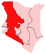
Rift Valley Province, Kenya
Encyclopedia
Rift Valley Province of Kenya
, bordering Uganda
, is one of Kenya's seven administrative provinces outside Nairobi
.
Rift Valley Province is the largest and one of the most economically important provinces in Kenya
. It is dominated by the Great Rift Valley
which passes through it and gives the province its name. According to the 1999 Census, the province covers an area of 173854 km² (42,960,221 acre; 67,125.4 sq mi) and has a population of 8,786,300 inhabitants (2007), making it the largest and most populous province in the country. The capital is the town of Nakuru
.
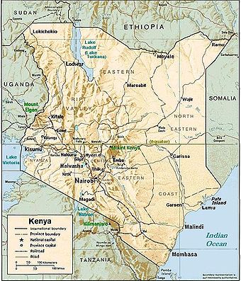 The Great Rift Valley runs south through Kenya from Lake Turkana
in the north and has several unique geographical features, including the Elgeyo escarpment
which is a popular tourist attraction.
Apart from the Rift Valley itself, the area has other important geographic features such as: the extinct volcanoes Mount Longonot
and Mount Suswa and Lake Baringo
, Lake Bogoria
, Lake Magadi
, Lake Nakuru
, Lake Naivasha
, the Suguta Valley, and Lake Turkana
.
basement, while the Kenya rift basin (a typical extensional basin) hosts Tertiary
volcanics that cover Mesozoic
sediments (Recently these sediments have been considered for oil exploration ). The sedimentary basin
s evolved along the Anza trough
during the Late Paleozoic
to Early Tertiary times through extension tectonics during the major Gondwana
land breakup. In the Miocene
Period the region underwent intermittent uplift and subsidence along major boundary faults accompanied by the large outpouring of lava flows. The Anza trough intersects the modern rift valley in the area of Lake Turkana. Rifting still continues today; primarily in the north, where active volcanoes are more plentiful.
from the highlands in the Kericho
district enjoy a world wide reputation, but horticulture
is an important part of the district's economy and cattle raising is also practised to a large extent.
The full economic potential of the Rift Valley region is, however, far from fully exploited and the current growth in population and improved education will hopefully change this in a near future. People in the province are still mostly rural, but urbanisation is gradually increasing; new cities and towns contain the rural-urban migration and, provided the right policies are instituted, the Rift Valley province will be able to emerge as a national economic and cultural hub.
Baringo
Bomet
Buret
Kajiado
Keiyo
Kericho
Koibatek
Laikipia
Marakwet
Nakuru
Nandi
Narok
Samburu
Trans Mara
Trans-Nzoia
Turkana
Uasin Gishu
West Pokot
Kenya
Kenya , officially known as the Republic of Kenya, is a country in East Africa that lies on the equator, with the Indian Ocean to its south-east...
, bordering Uganda
Uganda
Uganda , officially the Republic of Uganda, is a landlocked country in East Africa. Uganda is also known as the "Pearl of Africa". It is bordered on the east by Kenya, on the north by South Sudan, on the west by the Democratic Republic of the Congo, on the southwest by Rwanda, and on the south by...
, is one of Kenya's seven administrative provinces outside Nairobi
Nairobi
Nairobi is the capital and largest city of Kenya. The city and its surrounding area also forms the Nairobi County. The name "Nairobi" comes from the Maasai phrase Enkare Nyirobi, which translates to "the place of cool waters". However, it is popularly known as the "Green City in the Sun" and is...
.
Rift Valley Province is the largest and one of the most economically important provinces in Kenya
Kenya
Kenya , officially known as the Republic of Kenya, is a country in East Africa that lies on the equator, with the Indian Ocean to its south-east...
. It is dominated by the Great Rift Valley
Great Rift Valley
The Great Rift Valley is a name given in the late 19th century by British explorer John Walter Gregory to the continuous geographic trench, approximately in length, that runs from northern Syria in Southwest Asia to central Mozambique in South East Africa...
which passes through it and gives the province its name. According to the 1999 Census, the province covers an area of 173854 km² (42,960,221 acre; 67,125.4 sq mi) and has a population of 8,786,300 inhabitants (2007), making it the largest and most populous province in the country. The capital is the town of Nakuru
Nakuru
Nakuru, the provincial capital of Kenya's Rift Valley province, with roughly 300,000 inhabitants, and currently the fourth largest urban centre in the country, lies about 1850 m above sea level...
.
Geography
Lake Turkana
Lake Turkana , formerly known as Lake Rudolf, is a lake in the Great Rift Valley in Kenya, with its far northern end crossing into Ethiopia. It is the world's largest permanent desert lake and the world's largest alkaline lake...
in the north and has several unique geographical features, including the Elgeyo escarpment
Elgeyo escarpment
Elgeyo escarpment is a fault-scarp caused by post-Miocene faulting and there are Miocene beds visible. The escarpment is part of the western wall of the Great Rift Valley....
which is a popular tourist attraction.
Apart from the Rift Valley itself, the area has other important geographic features such as: the extinct volcanoes Mount Longonot
Mount Longonot
Mount Longonot is a dormant stratovolcano located southeast of Lake Naivasha in the Great Rift Valley of Kenya, Africa. It is thought to have last erupted in the 1860s. Its name is derived from the Maasai word oloonong'ot, meaning "mountains of many spurs" or "steep ridges".Mount Longonot is...
and Mount Suswa and Lake Baringo
Lake Baringo
Lake Baringo is, after Lake Turkana, the most northern of the Great Rift Valley lakes of Kenya, with a surface area of about and an elevation of about . The lake is fed by several rivers, El Molo, Perkerra and Ol Arabel, and has no obvious outlet; the waters are assumed to seep through lake...
, Lake Bogoria
Lake Bogoria
Lake Bogoria is a saline, alkaline lake that lies in a volcanic region in a half-graben basin south of Lake Baringo, Kenya, a little north of the equator. Lake Bogoria, like Lake Nakuru, Lake Elmenteita, and Lake Magadi further south in the Rift Valley, and Lake Logipi to the north, is home at...
, Lake Magadi
Lake Magadi
Lake Magadi is the southernmost lake in the Kenya Rift Valley, lying in a catchment of faulted volcanic rocks, north of Tanzania's Lake Natron. During the dry season, it is 80% covered by soda and is well known for its wading birds, including flamingos....
, Lake Nakuru
Lake Nakuru
Lake Nakuru is one of the Rift Valley soda lakes at an elevation of 1754 m above sea level. It lies to the south of Nakuru, in the rift valley of Kenya and is protected by Lake Nakuru National Park....
, Lake Naivasha
Lake Naivasha
Lake Naivasha is a freshwater lake in Kenya, lying north west of Nairobi, outside the town of Naivasha. It is part of the Great Rift Valley. The name derives from the local Maasai name Nai'posha, meaning "rough water" because of the sudden storms which can arise...
, the Suguta Valley, and Lake Turkana
Lake Turkana
Lake Turkana , formerly known as Lake Rudolf, is a lake in the Great Rift Valley in Kenya, with its far northern end crossing into Ethiopia. It is the world's largest permanent desert lake and the world's largest alkaline lake...
.
Geology
A large part of Kenya is underlain by PrecambrianPrecambrian
The Precambrian is the name which describes the large span of time in Earth's history before the current Phanerozoic Eon, and is a Supereon divided into several eons of the geologic time scale...
basement, while the Kenya rift basin (a typical extensional basin) hosts Tertiary
Tertiary
The Tertiary is a deprecated term for a geologic period 65 million to 2.6 million years ago. The Tertiary covered the time span between the superseded Secondary period and the Quaternary...
volcanics that cover Mesozoic
Mesozoic
The Mesozoic era is an interval of geological time from about 250 million years ago to about 65 million years ago. It is often referred to as the age of reptiles because reptiles, namely dinosaurs, were the dominant terrestrial and marine vertebrates of the time...
sediments (Recently these sediments have been considered for oil exploration ). The sedimentary basin
Sedimentary basin
The term sedimentary basin is used to refer to any geographical feature exhibiting subsidence and consequent infilling by sedimentation. As the sediments are buried, they are subjected to increasing pressure and begin the process of lithification...
s evolved along the Anza trough
Anza trough
The Anza trough is a rift in Kenya that was formed in the Jurassic Period of the Mesozoic Era.The trough runs inland from the coast in the northwest direction....
during the Late Paleozoic
Paleozoic
The Paleozoic era is the earliest of three geologic eras of the Phanerozoic eon, spanning from roughly...
to Early Tertiary times through extension tectonics during the major Gondwana
Gondwana
In paleogeography, Gondwana , originally Gondwanaland, was the southernmost of two supercontinents that later became parts of the Pangaea supercontinent. It existed from approximately 510 to 180 million years ago . Gondwana is believed to have sutured between ca. 570 and 510 Mya,...
land breakup. In the Miocene
Miocene
The Miocene is a geological epoch of the Neogene Period and extends from about . The Miocene was named by Sir Charles Lyell. Its name comes from the Greek words and and means "less recent" because it has 18% fewer modern sea invertebrates than the Pliocene. The Miocene follows the Oligocene...
Period the region underwent intermittent uplift and subsidence along major boundary faults accompanied by the large outpouring of lava flows. The Anza trough intersects the modern rift valley in the area of Lake Turkana. Rifting still continues today; primarily in the north, where active volcanoes are more plentiful.
Economy
The highlands provide adequate rainfall for farming and agriculture which is the economic base of the residents of the Rift Valley. TeaTea
Tea is an aromatic beverage prepared by adding cured leaves of the Camellia sinensis plant to hot water. The term also refers to the plant itself. After water, tea is the most widely consumed beverage in the world...
from the highlands in the Kericho
Kericho
Kericho is a Kenyan County located to the South West of the country and lies within the highlands west of The Great Rift Valley. The capital of the district is Kericho town. The district home to the best of Kenyan Tea which is world famous for its brightness, attractive color, brisk flavor and...
district enjoy a world wide reputation, but horticulture
Horticulture
Horticulture is the industry and science of plant cultivation including the process of preparing soil for the planting of seeds, tubers, or cuttings. Horticulturists work and conduct research in the disciplines of plant propagation and cultivation, crop production, plant breeding and genetic...
is an important part of the district's economy and cattle raising is also practised to a large extent.
The full economic potential of the Rift Valley region is, however, far from fully exploited and the current growth in population and improved education will hopefully change this in a near future. People in the province are still mostly rural, but urbanisation is gradually increasing; new cities and towns contain the rural-urban migration and, provided the right policies are instituted, the Rift Valley province will be able to emerge as a national economic and cultural hub.
Ethnicity
The people of the Rift Valley are a mesh work of different tribal identities, and the Kalenjin and the Maasai are two of the best known ethnic groups. Most of Kenya's top runners comes from the Kalenjin community. The Maasai people have the most recognizable cultural identity, both nationally and internationally, and serve as Kenya's international cultural symbol.Districts
District :Baringo
Baringo District
Baringo District is an administrative district in the Rift Valley Province of Kenya. Its capital town is Kabarnet. The district has a population of 264,978 and an area of 8,646 km² ....
Bomet
Bomet District
Bomet District is an administrative district in the Rift Valley Province of Kenya. Its capital town is Bomet. The district has a population of 382,794 and an area of 1,882 km² .The district has three electoral constituencies:...
Buret
Buret District
Buret District is an administrative district in the Rift Valley Province of Kenya. Its capital town is Litein. The district has a population of 316,882 and an area of 955 km² . The district has two electoral constituencies: Konoin Constituency and Bureti Constituency ....
Kajiado
Kajiado District
Kajiado District is an administrative district in the Rift Valley Province of Kenya. It has a population of 406,054 and an area of 21,903 km². The district borders Nairobi city and extends to the Kenya-Tanzania border further south. The district capital is Kajiado.The district is divided into seven...
Keiyo
Keiyo District
Keiyo District is an administrative district in the Rift Valley Province of Kenya. The district was formed in 1994, when Elgeyo/Marakwet-District was split into two, the other half is Marakwet District of today. Keiyo District has a population of 143.865...
Kericho
Kericho District
Kericho is a district in the Rift Valley Province of Kenya. Its capital town is Kericho. It has a population of 468,493 and an area of 2,111 km² .The district has three constituencies:*Belgut Constituency*Ainamoi Constituency...
Koibatek
Koibatek District
Koibatek District is an administrative district in the Rift Valley Province of Kenya. Its capital town is Eldama Ravine. The district has a population of 138,163 and an area of 2,306 km² .The district has two electoral constituencies:*Mogotio Constituency...
Laikipia
Marakwet
Marakwet District
Marakwet District is an administrative district in the Rift Valley Province of Kenya. Its capital town is Kapsowar. The district has a population of 140.629 . Local people are predominantly of the Marakwet tribe....
Nakuru
Nakuru District
Nakuru District is a district in the Rift Valley Province, Kenya. The district capital is Nakuru. With a population of 1,187,039 , it is the second largest district in Kenya after Nairobi. Nakuru District has an area of 7,242 km²....
Nandi
Nandi District
Nandi District is an administrative district in the Rift Valley Province of Kenya. Its capital town is Kapsabet. The district has a population of 578,751 .The topography of the district is dominated by the Nandi Hills...
Narok
Narok District
Narok District is an administrative district in Kenya. The Narok District is located in the Rift Valley Province, and has a population of 365,750...
Samburu
Samburu District
Samburu District is a district in Rift Valley Province, Kenya. It covers an area of roughly 21,000 km² in northern Kenya where the Samburu tribe live...
Trans Mara
Trans Mara District
Trans Mara District is an administrative district in the Rift Valley Province of Kenya. Its capital town is Kilgoris. The district has a population of 170,591 and an area of 2,846 km²...
Trans-Nzoia
Trans-Nzoia District
Trans-Nzoia District is an administrative district of Rift Valley Province, Kenya.It is located between the Nzoia River and Mount Elgon and its centre is the town of Kitale.Historically the area has been inhabited by the Kalenjin people...
Turkana
Turkana District
Turkana District is an administrative district in the Rift Valley Province of Kenya. Turkana is the northwesternmost district in Kenya. It is bordered by the countries of Uganda to the west; South Sudan and Ethiopia, including the disputed Ilemi Triangle, to the north and northeast; and Lake...
Uasin Gishu
Uasin Gishu District
Uasin Gishu District is one of the seventy-one districts of Kenya, located in the Rift Valley Province. The city of Eldoret is its capital, administrative center and commercial center....
West Pokot
West Pokot District
West Pokot District is an administrative district in the Rift Valley Province of Kenya. Its capital town is Kapenguria. The district has a population of 308,086 and an area of 9,064 km² . Pokot people inhabit the area....
Districts after 2007
Several new districts have been created since 2007 in Kenya, also in Rift Valley Province :| District | Capital |
|---|---|
| Baringo Central | Kabarnet Kabarnet Kabarnet is a town in the Rift Valley Province of Kenya. The town has an urban population of 9,583 and a total population of 24,661 - Geography :... |
| Baringo North | Kabartonjo Kabartonjo Kabartonjo is the district headquarters of Baringo North District, Rift Valley Province, Kenya.Kabartonjo has a population of about 2,000. Its residents are mainly of the Arror dialect of the Tugen sub-tribe in the Kalenjin cluster. Kabartonjo was founded in the early 20th century by Scottish... |
| Belgut | Sosiot |
| Bomet Bomet District Bomet District is an administrative district in the Rift Valley Province of Kenya. Its capital town is Bomet. The district has a population of 382,794 and an area of 1,882 km² .The district has three electoral constituencies:... |
Bomet Bomet Bomet is a city in the Rift Valley Province, Kenya. It is the capital of Bomet District. Bomet has an urban population of 4426 and a total population of 42,024 . It is located along the B3 road between Nairobi and Kisii via Narok.... |
| Buret Buret District Buret District is an administrative district in the Rift Valley Province of Kenya. Its capital town is Litein. The district has a population of 316,882 and an area of 955 km² . The district has two electoral constituencies: Konoin Constituency and Bureti Constituency .... |
Litein Litein 'Litein' is a small town in the Rift Valley Province, Kenya. It is the capital of the Buret District. Litein has an urban population of 2300.The town is along the Kericho-Sotik road... |
| Chepalungu | Sigor |
| East Pokot | Chemolingot |
| Kajiado Kajiado District Kajiado District is an administrative district in the Rift Valley Province of Kenya. It has a population of 406,054 and an area of 21,903 km². The district borders Nairobi city and extends to the Kenya-Tanzania border further south. The district capital is Kajiado.The district is divided into seven... |
Kajiado Kajiado Kajiado is a town in the Rift Valley Province, Kenya. The town is located south of Nairobi, along the Nairobi – Arusha highway. Kajiado has an urban population of 8128 . Local people are predominantly of the Maasai tribe.... |
| Kajiado North | Ngong Ngong, Kenya Ngong is a town near the Ngong Hills along the Great Rift Valley, located in the southwest of Nairobi, in southern Kenya. The word "Ngong" is a Maasai word meaning "knuckles"... |
| Keiyo South Keiyo District Keiyo District is an administrative district in the Rift Valley Province of Kenya. The district was formed in 1994, when Elgeyo/Marakwet-District was split into two, the other half is Marakwet District of today. Keiyo District has a population of 143.865... |
Chepkorio Chepkorio Chepkorio is a village in Kenya's Rift Valley Province. It lies on the B54 highway, to the northwest of Kaptagat.... |
| Keiyo | Iten Iten Iten is a town in Rift Valley Province of Kenya. It is located along the road between Eldoret and Kabarnet. Elgeyo escarpment and Kerio River are located east of Iten. The town has a population of 4000 .... |
| Kericho Kericho District Kericho is a district in the Rift Valley Province of Kenya. Its capital town is Kericho. It has a population of 468,493 and an area of 2,111 km² .The district has three constituencies:*Belgut Constituency*Ainamoi Constituency... |
Kericho Kericho Kericho is a Kenyan County located to the South West of the country and lies within the highlands west of The Great Rift Valley. The capital of the district is Kericho town. The district home to the best of Kenyan Tea which is world famous for its brightness, attractive color, brisk flavor and... |
| Kipkelion | Kipkelion |
| Koibatek Koibatek District Koibatek District is an administrative district in the Rift Valley Province of Kenya. Its capital town is Eldama Ravine. The district has a population of 138,163 and an area of 2,306 km² .The district has two electoral constituencies:*Mogotio Constituency... |
Eldama Ravine Eldama Ravine Eldama Ravine is a kenyan town a few miles north of the equator,geographical coordinates 0° 30' 0" North, 35° 43' 0" East. It was established as an administrative point by British colonialists and later served as a transit route for lumber harvested from surrounding forests.It is the headquarters... |
| Konoin | Mogogosiek |
| Kuresoi | Keringet Keringet Keringet is a settlement in Kenya's Rift Valley Province.... |
| Kwanza | Endebess Endebess Endebess is both an administrative division and a small town that houses the headquarters for the division in Trans-Nzoia District, Rift Valley Province, Kenya... |
| Laikipia Central | Sweetwaters |
| Laikipia East | Nanyuki Nanyuki Nanyuki is a market town in central-east Rift Valley region of Kenya lying northwest of Mount Kenya along the A2 road and at the terminus of the branch railway from Nairobi. It is situated just north of the Equator . It was founded in 1907 by British settlers, some of whose descendants still live... |
| Laikipia North | Mukogodo |
| Laikipia West | Rumuruti Rumuruti Rumuruti is a settlement in Kenya's Rift Valley Province.... |
| Loitokitok Loitokitok District -Location:The district is located in Rift Valley Province, in southeastern Kenya, at the border with the Republic of Tanzania, adjacent to Mount Kilimanjaro... |
Loitokitok Loitokitok -Location:The town is located in Loitokitok District, Rift Valley Province, in southeastern Kenya, at the International border with Tanzania. The town lies within the foothills and in full view of Mount Kilimanjaro.... |
| Loima | Lorugum |
| Marakwet East | Tot TOT TOT may refer to:* TOT , a telecommunications company* Tater Tots, a fried potato dish* Terms of trade, a concept in economics* Theatre of Tragedy, a musical group* Theology on Tap, a program of Christian talks and fellowship... |
| Marakwet West | Kapsowar Kapsowar Kapsowar is a small town in the Rift Valley Province, Kenya. In 1994 Kapsowar became the headquarters of the Marakwet District. Prior to this, the Marakwet and Keiyo tribes were collectively grouped into the Elgeiyo-Markwet District... |
| Marigat | Marigat Marigat Marigat is a settlement in Kenya's Rift Valley Province.Marigat is a fast growing town located in the lowlands of Baringo district. Its growth is supported by the Perkerra irrigation scheme where onions, pepper, papaws and maize, among other crops, are grown. Marigat town is about 20 km from... |
| Mogotio | Mogotio Mogotio Mogotio is a settlement in Kenya's Rift Valley Province.... |
| Molo | Molo Molo, Kenya Molo is a town in western Kenya. It is served by a branch of Kenya Railways, formerly the Uganda Railway, East African Railways Corporation until 1977. Molo hosts a town council and an administrative division in the Nakuru District of Rift Valley Province... |
| Naivasha | Naivasha Naivasha Naivasha is a market town in Rift Valley Province, Kenya, lying north west of Nairobi. It is located on the shore of Lake Naivasha and along the Nairobi - Nakuru highway and Uganda Railway.Naivasha is part of the Nakuru District... |
| Nakuru Nakuru District Nakuru District is a district in the Rift Valley Province, Kenya. The district capital is Nakuru. With a population of 1,187,039 , it is the second largest district in Kenya after Nairobi. Nakuru District has an area of 7,242 km².... |
Nakuru Nakuru Nakuru, the provincial capital of Kenya's Rift Valley province, with roughly 300,000 inhabitants, and currently the fourth largest urban centre in the country, lies about 1850 m above sea level... |
| Nakuru North (Subukia) | Bahati |
| Nandi Central | Kapsabet Kapsabet Kapsabet is a town in the Rift Valley Province, Kenya. It is the capital of Nandi Central District. Kapsabet hosts a municipal council and divisional headquarters of Kapsabet administrative division... |
| Nandi East | Nandi Hills Nandi Hills, Kenya Nandi Hills is a highland area of lush green rolling hills at the edge of the Great Rift Valley in the Rift Valley Province of Kenya. The scenic area is known for its tea estates, and is home to many world-renowned athletes, including Kipchoge Keino, Nandi Hills is a highland area of lush green... |
| Nandi North | Kabiyet Kabiyet Kabiyet is a settlement in Kenya's Rift Valley Province.... |
| Nandi South | Kobujoi |
| Narok North | Narok Narok Narok is an town west of Nairobi that supports Kenya's economy in south-west Kenya, along the Great Rift Valley. Narok is the district capital of the Narok County and stands as the major centre of commerce in the district. Narok has a population of around 40,000 people, mostly Maasai... |
| Narok South | Ololulunga |
| Njoro | Njoro Njoro Njoro is an agricultural town 18 km west south west of Nakuru, Kenya. Njoro is the divisional headquarters of Njoro Division of Nakuru District. It houses the divisional headquarters of the provincial administration and the police.- Brief history :... |
| North Pokot | Alale |
| Nyahururu | Nyahururu Nyahururu Nyahururu is a town in Kenya, lying east of Nakuru. It is part of Laikipia District in Rift Valley Province. Despite this, Nyahururu formerly functioned as the administrative capital of Nyandarua District, one of seven districts that constitute Central Province in Kenya, until the headquarters... |
| Pokot Central | Sighor |
| Rongai | Rongai Rongai Rongai is a town in Nakuru District, Rift Valley Province, Kenya. It lies 30 km west of Nakuru, along the A104 Road and the railway line between Nakuru and Uganda. It is about 10 kilometres north of Elburgon and 15 kilometres east of Molo . The town lies 1912 m above sea level and has a... |
| Samburu Central | Mararal |
| Samburu East | Wamba Wamba, Kenya Wamba is a small town in Samburu District, Rift Valley Province in central Kenya. It is located south-southwest edge of the Mathews Range, and northwest of the Samburu National Reserve... |
| Samburu North | Baragoi Baragoi Baragoi is a market town in Kenya, lying north of Maralal and east of the Suguta Valley. It is part of the Samburu District. The entire Baragoi division has a population of nearly 20.000 comprising mostly people from the Samburu and Turkana tribes.... |
| Sotik | Sotik |
| Tinderet | Maraba Maraba Maraba may refer to:* Marabá, a municipality in the state of Pará in Brazil* Maraba, Rwanda, a location in southern Rwanda* Maraba Coffee, a fairtrade coffee produced in the Maraba area of Rwanda... |
| Trans Mara East | Murkhan |
| Trans Mara West | Kilgoris Kilgoris Kilgoris is a town in the Rift Valley Province, Kenya. It is the capital of the Trans Mara District. The town has a population of 4500 .... |
| Trans-Nzoia East | Maili Saba |
| Trans-Nzoia West | Kitale Kitale Kitale is an agricultural town in western Kenya situated between Mount Elgon and the Cherengani Hills at an elevation of around . Its urban population was estimated at 220,000 in 2007.... |
| Turkana Central | Lodwar Lodwar Lodwar is the largest town in northwestern Kenya, located west of Lake Turkana on the A1 road. Its main industries are basket weaving and tourism. The Loima Hills lie to its west. Lodwar is the capital of Turkana District... |
| Turkana East | Lokori Lokori Lokori is a settlement in Kenya's North Eastern Province.... |
| Turkana North | Lokitaung Lokitaung Lokitaung is a settlement in Kenya's Rift Valley Province.... |
| Turkana South | Lokichar Lokichar - External links :*... |
| Turkana West | Kakuma Kakuma Kakuma town is located in Turkana District, in the northwestern region of Kenya. Kakuma is the Swahili word for "nowhere", epitomizing the seclusion of the area.... |
| Uasin Gishu North (Eldoret West) | Eldoret Eldoret Eldoret is a town in western Kenya and the administrative centre of Uasin Gishu District of Rift Valley Province. Lying south of the Cherangani Hills, the local elevation varies from about 2100 metres above sea level at the airport to more than 2700 metres in nearby areas... |
| Uasin Gishu South (Eldoret East) | Naiberi |
| Wareng | Outspan |
| West Pokot West Pokot District West Pokot District is an administrative district in the Rift Valley Province of Kenya. Its capital town is Kapenguria. The district has a population of 308,086 and an area of 9,064 km² . Pokot people inhabit the area.... |
Kapenguria Kapenguria Kapenguria is a town lying north east of Kitale on the A1 road in Kenya. Kapenguria is capital of the West Pokot District. Kapenguria forms a municipality with an urban population of 13,000 and a total population of 56,000 .... |