
Loch Ryan
Encyclopedia
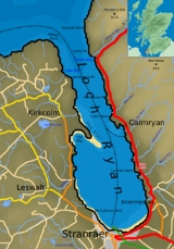
Loch Ryan is a Scottish sea loch that acts as an important natural harbour for shipping, providing calm waters for ferries operating between Scotland and Northern Ireland
. The town of Stranraer
is the largest settlement on its shores, with boats operating both from the town and from the village of Cairnryan
further north on the loch.
 Loch Ryan is orientated on a north-south axis, its mouth looking northward into the North Atlantic and Firth of Clyde
, and the town of Stranraer
sitting on its southern shores. The loch is bounded by the Rhins of Galloway
peninsula on its western side and the Scottish landmass in the east (comprising Galloway
and South Ayrshire
), the northern points of the loch are Milleur Point and Finnarts Point. The loch itself is about 8 miles (12.9 km) long from north to south, and about 3 miles (4.8 km) wide at its widest point. Nearby roads include the A77
in the east and the A718 in the west.
The Loch Ryan basin as it is seen today formed as a result of geological and glacial activity. The first period of activity occurred during the Paleozoic
era, with two periods of change. Firstly, during the Devonian
period (360 to 416 million years ago) the land in the area underwent a series of shearing events which considerably altered its shape, forming a basin. Then, during the Permian
period (250 to 300 million years ago) this basin filled up with sediments which were compacted to form soft sandstones. At this point in time the area would have been positioned around the equator and would form part of the Pangaea
supercontinent
. The second period of activity was as a result of the numerous glacial episodes during the Quaternary
period, from 2 million years ago up until the last glaciers retreated 10,000 years ago. As all of northern Europe experienced numerous Ice age
s, glacier
formation created ice flows and Ice sheet
s. The erosive force of the ice moved across the land, removing the soft sandstone and leaving behind the harder rocks. When the ice sheet melted with the rising temperatures 10,000 years ago the basin was uncovered and was flooded by the sea, forming the loch that is seen today.
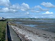
Since the end of the last ice-age the sea has continued to change the loch by erosion and deposition. The loch has a sandbank on its western shores called 'the Scar'. This bank, just south of the village of Kirkcolm, is an important breeding ground for terns.
 Historically the loch has seen human activity on its shores since ancient times. Sheltered from the rough seas of the North Channel
and the North Atlantic the loch has been an important safe harbour for vessels. In early 1307 at the beginning of Robert the Bruce's
campaign in the wars of independence
he sent two forces to attempt to gain control of south west Scotland. One force, led by his two brothers, consisting of eighteen galleys, landed in Loch Ryan. They were immediately overwhelmed by local forces, led by Dougal MacDougal, who was a supporter of the Comyns.
The loch would have been used historically for traditional maritime activities including fishing. The Statistical account of Scotland
1791-99, records:
The later Account of 1834-45 expands on this issue, as it states:
A lighthouse was built at Cairn point in 1847 at the northern end of the village of Cairnryan. In 1849 the principal link to Northern Ireland was moved from Portpatrick
to Stranraer in Loch Ryan. The reasons for this move were the increasing tonnages of the vessels operating the route which were more susceptible to harsh storms when moored at the exposed Portpatrick harbour on the Rhins
coast. The calmer safer waters of the loch allowed larger ships to ply the route as demand increased.
During the second world war
the loch was busy with wartime activity. Cairnryan became No. 2 Military port, an important secondary large-scale port facility that was available for use should facilities on the Mersey
and the Clyde
became unavailable due to enemy bombing. Two large piers were built at Cairnryan to enable large ships to dock and unload cargo. The harbour was used as an import point for troops coming from the USA after 1942. Only one of the two piers still stands today, and it is unusable due to the poor condition of the wooden piles (the pier has been unused since a small section collapsed with tragic consequences in the 1990s). With the U-boat
menace in the Atlantic taking a heavy toll on merchant shipping the area became an important centre for anti-U-boat operations. Flying boats operated from the loch to protect allied shipping making its way to Liverpool or Glasgow either via the North Channel
or the Firth of Clyde
. There were two RAF stations on the loch, RAF Wig Bay operating from Wig Bay near Kirkcolm and RAF Stranraer operating from the town.
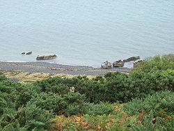 Just north of Cairnryan are what looks like a number of concrete 'boats' resting on the shore - these too are a legacy of the second world war. They are 'Beetles' from the Mulberry harbour project. The beetle pontoons were used to hold up the 'Whale' roadway sections, with four of the whales being built at Cairnryan. With easy access to the North Atlantic, Loch Ryan was used as the surrender destination for the U-boats which were out in the Atlantic in 1945 when hostilities ceased. The U-boats and their crews were held at Cairnryan, before the boats were finally towed out into the Atlantic and sunk
. Other wartime activity on the loch included construction of target rafts made out of wood and cork, which were built in Stranraer then floated out the Loch and round the Rhins of Galloway to their positions in Luce Bay
for bombing practice (operating out of West Freugh). The loch was used by Winston Churchill
when he departed from Stranraer in a Boeing Flying boat on 25 June 1942 when making his second visit of the war to the USA.
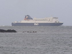 Today the loch serves as an important location for the ferry link to Northern Ireland
, representing the shortest crossing distance between Britain and Ireland. The port activity has increased substantially since the route first started operating out of the loch in 1849. There are currently a total of 6 ferries, 4 conventional RORO
ferries and 2 fast ferries. This is split between two ferry companies, Stena Line
and P&O - Irish Sea. Stena, operating from the east pier in Stranraer, with 2 conventionals (Stena Caledonia & Stena Navigator) and the HSS fast ferry (Stena Voyager), while P&O, operating from Cairnryan
run 2 conventionals (European Causeway & European Highlander) and the P&O Express fast ferry. Between 1992 and 1999 Sea Containers Ltd
operated the SeaCat
fast ferry on the Stranraer - Belfast route. They subsequently moved to Troon
, before finally ending the service altogether in 2005. While conventional ferries (moving at around 15 knots) have worked the route for many decades the newly introduced fast ferries are capable of much greater speeds (around 40 knots). The wash that these large craft generate has led to speed restrictions being imposed within the majority of the loch, with fast ferries unable to increase their speeds above 12 knots (23.5 km/h) until they are to the north of Old House point on the northern side of Cairnryan.
 Further speed restrictions are imposed on the HSS during the tern breeding season, when wash from the ship can cause problems for the breeding birds on the Scar. The levels of wash that the fast ferries create has been the subject of some controversy, with many suggesting that the death by drowning of a man and his two sons in the loch in July 2003 was due to their boat being overwhelmed by a large wave created by a nearby passing ferry. The Marine Accident Investigation Branch report on the incident suggested however that the condition of the boat, the lack of safety equipment onboard and a poor look out were more likely to have been contributing factors, but did emphasise that speed limits should be adhered to and that small boat owners should be made aware of the dangers of ferry-induced washes. There has also recently been criticism of the erosion that the wash from the boats are creating in and around Kirkcolm bay on the loch's western shores. The questions of speed and the environmental impact that it has have to be balanced with the efficiency and speed of operation, with the Loch Ryan - Northern Ireland route under pressure from other competing routes and methods of transport, not least the Holyhead
- Dublin ferry link and low cost airlines.
 It is this pressure on efficiency and crossing time that has led to the decision of Stena proposals to move in a few years its operations from Stranraer further north to Cairnryan to share facilities with P&O. This will allow them to cut out the slowest part of the journey, enabling the HSS to reduce its overall roundtrip time by around 30 minutes. This proposal, coming as it does with a significant redevelopment and investment in new port facilities at Cairnryan, will give good security to the future of the North Channel
route. It will also lead to future potential small craft maritime development at the southern end of the Loch, which will be completely free from large and regular ferry traffic. The Loch already sees small craft usage, with the Loch Ryan Sailing club operating from Wig Bay, and Stranraer Marina in Stranraer harbour beside the West Pier.

Northern Ireland
Northern Ireland is one of the four countries of the United Kingdom. Situated in the north-east of the island of Ireland, it shares a border with the Republic of Ireland to the south and west...
. The town of Stranraer
Stranraer
Stranraer is a town in the southwest of Scotland. It lies in the west of Dumfries and Galloway and in the county of Wigtownshire.Stranraer lies on the shores of Loch Ryan on the northern side of the isthmus joining the Rhins of Galloway to the mainland...
is the largest settlement on its shores, with boats operating both from the town and from the village of Cairnryan
Cairnryan
Cairnryan is a small Scottish village in Dumfries and Galloway on the eastern shore of Loch Ryan. The village has been of vital importance in maritime history.-Ferry Port:...
further north on the loch.
Location and geography
Firth of Clyde
The Firth of Clyde forms a large area of coastal water, sheltered from the Atlantic Ocean by the Kintyre peninsula which encloses the outer firth in Argyll and Ayrshire, Scotland. The Kilbrannan Sound is a large arm of the Firth of Clyde, separating the Kintyre Peninsula from the Isle of Arran.At...
, and the town of Stranraer
Stranraer
Stranraer is a town in the southwest of Scotland. It lies in the west of Dumfries and Galloway and in the county of Wigtownshire.Stranraer lies on the shores of Loch Ryan on the northern side of the isthmus joining the Rhins of Galloway to the mainland...
sitting on its southern shores. The loch is bounded by the Rhins of Galloway
Rhins of Galloway
The Rhins of Galloway is a hammer-head peninsula in Dumfries and Galloway, Scotland...
peninsula on its western side and the Scottish landmass in the east (comprising Galloway
Galloway
Galloway is an area in southwestern Scotland. It usually refers to the former counties of Wigtownshire and Kirkcudbrightshire...
and South Ayrshire
Ayrshire
Ayrshire is a registration county, and former administrative county in south-west Scotland, United Kingdom, located on the shores of the Firth of Clyde. Its principal towns include Ayr, Kilmarnock and Irvine. The town of Troon on the coast has hosted the British Open Golf Championship twice in the...
), the northern points of the loch are Milleur Point and Finnarts Point. The loch itself is about 8 miles (12.9 km) long from north to south, and about 3 miles (4.8 km) wide at its widest point. Nearby roads include the A77
A77 road
The A77 road is a major road in Scotland. It runs in a southwesternly direction from the city of Glasgow, past the towns of Giffnock, Newton Mearns, Kilmarnock, Prestwick, Ayr, Maybole, Girvan and Stranraer to the town of Portpatrick on the Irish Sea...
in the east and the A718 in the west.
The Loch Ryan basin as it is seen today formed as a result of geological and glacial activity. The first period of activity occurred during the Paleozoic
Paleozoic
The Paleozoic era is the earliest of three geologic eras of the Phanerozoic eon, spanning from roughly...
era, with two periods of change. Firstly, during the Devonian
Devonian
The Devonian is a geologic period and system of the Paleozoic Era spanning from the end of the Silurian Period, about 416.0 ± 2.8 Mya , to the beginning of the Carboniferous Period, about 359.2 ± 2.5 Mya...
period (360 to 416 million years ago) the land in the area underwent a series of shearing events which considerably altered its shape, forming a basin. Then, during the Permian
Permian
The PermianThe term "Permian" was introduced into geology in 1841 by Sir Sir R. I. Murchison, president of the Geological Society of London, who identified typical strata in extensive Russian explorations undertaken with Edouard de Verneuil; Murchison asserted in 1841 that he named his "Permian...
period (250 to 300 million years ago) this basin filled up with sediments which were compacted to form soft sandstones. At this point in time the area would have been positioned around the equator and would form part of the Pangaea
Pangaea
Pangaea, Pangæa, or Pangea is hypothesized as a supercontinent that existed during the Paleozoic and Mesozoic eras about 250 million years ago, before the component continents were separated into their current configuration....
supercontinent
Supercontinent
In geology, a supercontinent is a landmass comprising more than one continental core, or craton. The assembly of cratons and accreted terranes that form Eurasia qualifies as a supercontinent today.-History:...
. The second period of activity was as a result of the numerous glacial episodes during the Quaternary
Quaternary
The Quaternary Period is the most recent of the three periods of the Cenozoic Era in the geologic time scale of the ICS. It follows the Neogene Period, spanning 2.588 ± 0.005 million years ago to the present...
period, from 2 million years ago up until the last glaciers retreated 10,000 years ago. As all of northern Europe experienced numerous Ice age
Ice age
An ice age or, more precisely, glacial age, is a generic geological period of long-term reduction in the temperature of the Earth's surface and atmosphere, resulting in the presence or expansion of continental ice sheets, polar ice sheets and alpine glaciers...
s, glacier
Glacier
A glacier is a large persistent body of ice that forms where the accumulation of snow exceeds its ablation over many years, often centuries. At least 0.1 km² in area and 50 m thick, but often much larger, a glacier slowly deforms and flows due to stresses induced by its weight...
formation created ice flows and Ice sheet
Ice sheet
An ice sheet is a mass of glacier ice that covers surrounding terrain and is greater than 50,000 km² , thus also known as continental glacier...
s. The erosive force of the ice moved across the land, removing the soft sandstone and leaving behind the harder rocks. When the ice sheet melted with the rising temperatures 10,000 years ago the basin was uncovered and was flooded by the sea, forming the loch that is seen today.
Since the end of the last ice-age the sea has continued to change the loch by erosion and deposition. The loch has a sandbank on its western shores called 'the Scar'. This bank, just south of the village of Kirkcolm, is an important breeding ground for terns.
History and usage
North Channel (British Isles)
The North Channel is the strait which separates eastern Northern Ireland from southwestern Scotland...
and the North Atlantic the loch has been an important safe harbour for vessels. In early 1307 at the beginning of Robert the Bruce's
Robert I of Scotland
Robert I , popularly known as Robert the Bruce , was King of Scots from March 25, 1306, until his death in 1329.His paternal ancestors were of Scoto-Norman heritage , and...
campaign in the wars of independence
Wars of Scottish Independence
The Wars of Scottish Independence were a series of military campaigns fought between the independent Kingdom of Scotland and the Kingdom of England in the late 13th and early 14th centuries....
he sent two forces to attempt to gain control of south west Scotland. One force, led by his two brothers, consisting of eighteen galleys, landed in Loch Ryan. They were immediately overwhelmed by local forces, led by Dougal MacDougal, who was a supporter of the Comyns.
The loch would have been used historically for traditional maritime activities including fishing. The Statistical account of Scotland
Statistical Accounts of Scotland
The Statistical Accounts of Scotland are three series of documentary publications covering life in Scotland in the 18th, 19th and 20th centuries....
1791-99, records:
- "This bank abounds with oysters of a most excellent flavour. They are found indeed all around the shores and might be got in great quantities would people drag for them ....... A variety of fish, as skate, flounders, small cod, haddocks, whiting, lobsters, crabs and sometimes turbot are caught within the loch" http://stat-acc-scot.edina.ac.uk/link/1791-99/Wigton/Stranraer/1/358/
The later Account of 1834-45 expands on this issue, as it states:
- "Loch Ryan at one time was famous for its herring fishery. I have heard old people say that they have known 300 sail boats in the bay at one time which had come from the highlands and other places, in order to fish or purchase herrings. For many years past the shoals of herrings may be said to have deserted the loch." http://stat-acc-scot.edina.ac.uk/link/1834-45/Wigton/Stranraer/4/95/
A lighthouse was built at Cairn point in 1847 at the northern end of the village of Cairnryan. In 1849 the principal link to Northern Ireland was moved from Portpatrick
Portpatrick
Portpatrick is a village hanging on to the extreme south-westerly tip of mainland Scotland, cut into a cleft in steep cliffs.Dating back historically some 500 years, and built adjacent to the ruins of nearby Dunskey Castle, its position on the Rhins of Galloway affords visitors views of the...
to Stranraer in Loch Ryan. The reasons for this move were the increasing tonnages of the vessels operating the route which were more susceptible to harsh storms when moored at the exposed Portpatrick harbour on the Rhins
Rhins of Galloway
The Rhins of Galloway is a hammer-head peninsula in Dumfries and Galloway, Scotland...
coast. The calmer safer waters of the loch allowed larger ships to ply the route as demand increased.
During the second world war
World War II
World War II, or the Second World War , was a global conflict lasting from 1939 to 1945, involving most of the world's nations—including all of the great powers—eventually forming two opposing military alliances: the Allies and the Axis...
the loch was busy with wartime activity. Cairnryan became No. 2 Military port, an important secondary large-scale port facility that was available for use should facilities on the Mersey
Mersey
Mersey may refer to:* River Mersey, in northwest England* Mersea Island, off the coast of Essex in England * Mersey River in the Australian state* Electoral division of Mersey in the state of Tasmania, Australian...
and the Clyde
River Clyde
The River Clyde is a major river in Scotland. It is the ninth longest river in the United Kingdom, and the third longest in Scotland. Flowing through the major city of Glasgow, it was an important river for shipbuilding and trade in the British Empire....
became unavailable due to enemy bombing. Two large piers were built at Cairnryan to enable large ships to dock and unload cargo. The harbour was used as an import point for troops coming from the USA after 1942. Only one of the two piers still stands today, and it is unusable due to the poor condition of the wooden piles (the pier has been unused since a small section collapsed with tragic consequences in the 1990s). With the U-boat
U-boat
U-boat is the anglicized version of the German word U-Boot , itself an abbreviation of Unterseeboot , and refers to military submarines operated by Germany, particularly in World War I and World War II...
menace in the Atlantic taking a heavy toll on merchant shipping the area became an important centre for anti-U-boat operations. Flying boats operated from the loch to protect allied shipping making its way to Liverpool or Glasgow either via the North Channel
North Channel (British Isles)
The North Channel is the strait which separates eastern Northern Ireland from southwestern Scotland...
or the Firth of Clyde
Firth of Clyde
The Firth of Clyde forms a large area of coastal water, sheltered from the Atlantic Ocean by the Kintyre peninsula which encloses the outer firth in Argyll and Ayrshire, Scotland. The Kilbrannan Sound is a large arm of the Firth of Clyde, separating the Kintyre Peninsula from the Isle of Arran.At...
. There were two RAF stations on the loch, RAF Wig Bay operating from Wig Bay near Kirkcolm and RAF Stranraer operating from the town.
Operation Deadlight
Operation Deadlight was the code name for the scuttling of U-boats surrendered to the Allies after the defeat of Germany near the end of World War II....
. Other wartime activity on the loch included construction of target rafts made out of wood and cork, which were built in Stranraer then floated out the Loch and round the Rhins of Galloway to their positions in Luce Bay
Luce Bay
Luce Bay is a large bay in Wigtownshire in southern Scotland. The bay is 20 miles wide at its mouth and is bounded by the Rhins of Galloway to the west and the Machars to the east....
for bombing practice (operating out of West Freugh). The loch was used by Winston Churchill
Winston Churchill
Sir Winston Leonard Spencer-Churchill, was a predominantly Conservative British politician and statesman known for his leadership of the United Kingdom during the Second World War. He is widely regarded as one of the greatest wartime leaders of the century and served as Prime Minister twice...
when he departed from Stranraer in a Boeing Flying boat on 25 June 1942 when making his second visit of the war to the USA.
Northern Ireland
Northern Ireland is one of the four countries of the United Kingdom. Situated in the north-east of the island of Ireland, it shares a border with the Republic of Ireland to the south and west...
, representing the shortest crossing distance between Britain and Ireland. The port activity has increased substantially since the route first started operating out of the loch in 1849. There are currently a total of 6 ferries, 4 conventional RORO
RORO
Roll-on/roll-off ships are vessels designed to carry wheeled cargo such as automobiles, trucks, semi-trailer trucks, trailers or railroad cars that are driven on and off the ship on their own wheels...
ferries and 2 fast ferries. This is split between two ferry companies, Stena Line
Stena Line
Stena Line is one of the world's largest ferry operators, with ferry services serving Scotland, Sweden, Northern Ireland, Denmark, Norway, England, Wales, Ireland, Germany, the Netherlands and Poland. Stena Line is a major unit of Stena AB, itself a part of the Stena Sphere, a grouping of Stena AB,...
and P&O - Irish Sea. Stena, operating from the east pier in Stranraer, with 2 conventionals (Stena Caledonia & Stena Navigator) and the HSS fast ferry (Stena Voyager), while P&O, operating from Cairnryan
Cairnryan
Cairnryan is a small Scottish village in Dumfries and Galloway on the eastern shore of Loch Ryan. The village has been of vital importance in maritime history.-Ferry Port:...
run 2 conventionals (European Causeway & European Highlander) and the P&O Express fast ferry. Between 1992 and 1999 Sea Containers Ltd
Sea Containers Ltd
Sea Containers Ltd. is a Bermuda-registered company which operates two main business areas: transport and container leasing.In March 2006 the company sold its share of Orient-Express Hotels...
operated the SeaCat
SeaCat
SeaCat was the marketing name used by Sea Containers Ferries Scotland for its services between Northern Ireland, Scotland and England between 1992 and 2004. The company was originally based in Stranraer later moving to Belfast...
fast ferry on the Stranraer - Belfast route. They subsequently moved to Troon
Troon
Troon is a town in South Ayrshire. It is situated on the west coast of Scotland, about eight miles north of Ayr and three miles northwest of Glasgow Prestwick International Airport. Lying across the Firth of Clyde, the Isle of Arran can be seen. Troon is also a port with freight and ferry services...
, before finally ending the service altogether in 2005. While conventional ferries (moving at around 15 knots) have worked the route for many decades the newly introduced fast ferries are capable of much greater speeds (around 40 knots). The wash that these large craft generate has led to speed restrictions being imposed within the majority of the loch, with fast ferries unable to increase their speeds above 12 knots (23.5 km/h) until they are to the north of Old House point on the northern side of Cairnryan.
Holyhead
Holyhead is the largest town in the county of Anglesey in the North Wales. It is also a major port adjacent to the Irish Sea serving Ireland....
- Dublin ferry link and low cost airlines.
North Channel (British Isles)
The North Channel is the strait which separates eastern Northern Ireland from southwestern Scotland...
route. It will also lead to future potential small craft maritime development at the southern end of the Loch, which will be completely free from large and regular ferry traffic. The Loch already sees small craft usage, with the Loch Ryan Sailing club operating from Wig Bay, and Stranraer Marina in Stranraer harbour beside the West Pier.
Further reading
- Queens University Belfast study on Loch Ryan and the wake caused by fast ferries (PDF)
- BBC News report on July 2003 tragedy
- MAIB report on July 2003 tragedy (PDF)
- Bell, A. Stranraer in World War Two, Stranraer And District Local History Trust, 2005. ISBN 0-9542966-3-X
- BBC guide to a walk around Loch Ryan
- Photographs of some of the ferries that operate in Loch Ryan
- Undiscovered Scotland page on Cairnryan