
Pyuthan District
Encyclopedia
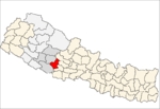
Pyuthan District
' onMouseout='HidePop("30020")' href="/topics/Rapti_Zone">Rapti
Zone
of Nepal
's Mid-Western
Region
. Pyuthan covers an area of 1,309 km² with population (2001) of 212,484. Pyuthan Khalanga is the district's administrative center.
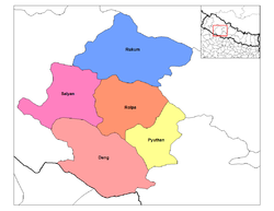
of Dhaulagiri Zone and the main watershed between the (west) Rapti
and Gandaki River basins. Pyuthan borders Rolpa district
to the west. Of the two upper tributaries of the West Rapti River
, Pyuthan contains all of Jhimruk Khola and the lower part of Madi Khola after it exits Rolpa. The Madi-Jhimruk confluence is in southern Pyuthan, in the Mahabharat Range. On the southeast Pyuthan borders Lumbini Zone
including Arghakhanchi
and Gulmi district
s.
The valley of Jhimruk Khola is the core of Pyuthan district. Its alluvial plain is intensively planted in rice
during the summer monsoon. Wheat
is grown as the winter crop. Madi Khola has eroded an inner gorge and is less suited to traditional irrigated agriculture.
and Chhetri farmers cultivate irrigated fields along the Jhimruk and unirrigated fields partway up the hillsides. They are served by Newar
merchants and service castes such as Damai (tailor
/musician), Gaine
(minstrel
), Kami (blacksmith
), Kumal (potter
), Sarki (tanner
/leatherworker
) and Sunar
(goldsmith
). Highlands around the valley are mostly inhabited by Magars, including Kham Magar
s at higher elevations. The district center Pyuthan Khalanga is situated on a hillside east of the Jhimruk, some 500 meters above it.
s and papaya
s. At about 800m elevation, the Jhimruk Valley approaches the upper limit for mango
es, however Madi Khola is lower. Citrus
, asian pear
and mulberries are grown as cash crops in surrounding hills. Maize is grown on sloping un-irrigated bari fields up to about 2,000m. Snow occasionally falls on adjacent peaks reaching 2,400m but seldom lasts more than a day or two.
is still in widespread use with limited use of biogas
.
Scheduled buses serve Pyuthan via a spur road off the main east-west Mahendra Highway
at Bhalubang in Lalmitiya
VDC, Deukhuri Valley. An old trade route was upgraded for motor vehicles in conjunction with the Jhimruk hydro project and is now (2010) being paved. A longer, now less-traveled gravel road from Tribhuvannagar
(Ghorahi) in Dang Valley traverses the Mahabharat Range to Tiram
, then descends toward Madi Khola to join the Bhalubang road at Devisthan. The Madi is then followed 1 km. upstream to Chakchake where a left fork continues further upstream into Rolpa district
while the main road climbs to cross a low pass at Cherneta and descend into the valley of Jhimruk Khola. At Bijuwar Bazaar
about 10 km. beyond Chakchake this road forks again with a branch continuing north along the Jhimruk while the main road crosses the Jhimruk and climbs to Khalanga the district's administrative center.
confederation before Prithvi Narayan Shah
unified modern Nepal in the second half of the 18th century. Since Dang Deukhuri District to the south and Salyan District
to the west belonged to another confederation called Baise Rajya, Pyuthan was a western outpost of the Chaubisi and probably a defense perimeter defended by forts, for example at Okharkot
.
Pyuthan is the home district of Mohan Bikram Singh
(1935-), a founder of the Communist Party of Nepal
. Singh's organizational work in Pyuthan and other districts of Rapti Zone laid the basis for the area becoming the so-called "heartland" of the Maoist insurgency 1996-2006 that cost over 12,000 lives but was instrumental in transforming the country from a kingdom ruled by the Shah dynasty
into a republic. Other prominent communist leaders from Pyuthan include Mohan Baidhya, Lila Mani Pokhrel, Bamdev Gautam and Navraj Subedi.
Pyuthan is also the home district of Anirudra Sharma (Parliament 1959-1960), Sibraj Subedi (former minister and Parliament 1991-1998), Mukti Prasad Sharma of Nepali Congress Party (Parliament 1991-1914) and Khem Raj Pandit of the conservative and royalist Rastriya Prajatantra Party
.
Districts of Nepal
Nepal's 14 administrative zones are subdivided into 75 districts . These districts are listed below, by zone...
' onMouseout='HidePop("30020")' href="/topics/Rapti_Zone">Rapti
Rapti Zone
Rapti Anchal in the Mid-Western Development Region of Nepal. It is named after the West Rapti River which drains Rolpa, Pyuthan and part of Dang district. The remainder of Dang and part of Salyan are drained by the Babai. The remainder of Salyan and all of Rukum are drained by the Bheri.The...
Zone
Zones of Nepal
Nepal is divided into 14 administrative zones , and 75 districts . The 14 administrative zones are grouped into five development regions...
of Nepal
Nepal
Nepal , officially the Federal Democratic Republic of Nepal, is a landlocked sovereign state located in South Asia. It is located in the Himalayas and bordered to the north by the People's Republic of China, and to the south, east, and west by the Republic of India...
's Mid-Western
Mid-Western Region, Nepal
Mid-Western Region is one of Nepal's five development regions. Westward from the Central region surrounding Kathmandu are the Western, Mid-Western and finally Far-Western regions. Counter-intuitively, Mid-Western lies west of Western....
Region
Regions of Nepal
Nepal is divided into 14 administrative zones , which are divided into 75 districts . The 14 administrative zones are grouped into five development regions...
. Pyuthan covers an area of 1,309 km² with population (2001) of 212,484. Pyuthan Khalanga is the district's administrative center.
Geography
Pyuthan borders Dang Deukhuri District to the southwest along the crest of the Mahabharat Range and extends about 50 km northeast through the Middle Hills to a 3,000+ meter ridge that is both Pyuthan's border with Baglung districtBaglung District
Baglung District, of 268,938.Baglung is surrounded by Parvat, Myagdi, Rukum, Ropla, Pyuthan and Gulmi districts. It looks like Nepal in shape. It has 59 Village Development Committees and one Municipality. It has many rivers and streams and so, many suspension bridges. Baglung is also known as the...
of Dhaulagiri Zone and the main watershed between the (west) Rapti
West Rapti River
Not to be confused with the East Rapti in Chitwan Valley some to the east, this Rapti drains Rapti Zone in Mid-Western Region, Nepal, then Awadh and Purvanchal regions of Uttar Pradesh state, India before joining the Ghaghara a major left bank tributary of the Ganges.The West Rapti is notable for...
and Gandaki River basins. Pyuthan borders Rolpa district
Rolpa District
Rolpa of 210,004. Livang is the district's administrative center.By Nepalese standards, Rolpa is an underdeveloped area plagued by low life expectancy and poverty . It was a major flashpoint in the 1996-2006 Civil War.Adjoining districts are Dang to the south, Pyuthan to the east, Salyan to the...
to the west. Of the two upper tributaries of the West Rapti River
West Rapti River
Not to be confused with the East Rapti in Chitwan Valley some to the east, this Rapti drains Rapti Zone in Mid-Western Region, Nepal, then Awadh and Purvanchal regions of Uttar Pradesh state, India before joining the Ghaghara a major left bank tributary of the Ganges.The West Rapti is notable for...
, Pyuthan contains all of Jhimruk Khola and the lower part of Madi Khola after it exits Rolpa. The Madi-Jhimruk confluence is in southern Pyuthan, in the Mahabharat Range. On the southeast Pyuthan borders Lumbini Zone
Lumbini Zone
Lumbini Zone, is one of the 14 zones of Nepal and is home to Lumbini site, the birthplace of Siddhartha Gautama, who later became the historical Buddha and founder of the Buddhist philosophy...
including Arghakhanchi
Arghakhanchi District
Arghakhanchi is one of the districts of Lumbini Zone in Nepal's Western Development Region. The district headquarters are Sandhikharka.-Etymology:...
and Gulmi district
Gulmi District
Gulmi District of 296,654. It is famous for coffee farming. Ruru, a Holy Place now also known as Ridi,is a market centre,where many of the tamples are situated.Maghe sankranti and other festivals are celebrated here. Many local as well as foreign tourists come here to visit the place...
s.
The valley of Jhimruk Khola is the core of Pyuthan district. Its alluvial plain is intensively planted in rice
Paddy field
A paddy field is a flooded parcel of arable land used for growing rice and other semiaquatic crops. Paddy fields are a typical feature of rice farming in east, south and southeast Asia. Paddies can be built into steep hillsides as terraces and adjacent to depressed or steeply sloped features such...
during the summer monsoon. Wheat
Wheat
Wheat is a cereal grain, originally from the Levant region of the Near East, but now cultivated worldwide. In 2007 world production of wheat was 607 million tons, making it the third most-produced cereal after maize and rice...
is grown as the winter crop. Madi Khola has eroded an inner gorge and is less suited to traditional irrigated agriculture.
Castes and Occupations
BahunBahun
Bahun is a colloquial Nepali term for a member of the Pahari or "hill" Brahmin caste, who are traditionally educators, scholars and priests of Hinduism. They are also known as Barmu in Newari. By tradition—and by civil law until 1962—they represented the highest of the four Hindu...
and Chhetri farmers cultivate irrigated fields along the Jhimruk and unirrigated fields partway up the hillsides. They are served by Newar
Newar
The Newa , Newār or Newāl) are the indigenous people and the creators of the historical civilization of Nepal's Kathmandu Valley. The valley and surrounding territory have been known from ancient times as Nepal Mandala, its limits ever changing through history.Newas have lived in the Kathmandu...
merchants and service castes such as Damai (tailor
Tailor
A tailor is a person who makes, repairs, or alters clothing professionally, especially suits and men's clothing.Although the term dates to the thirteenth century, tailor took on its modern sense in the late eighteenth century, and now refers to makers of men's and women's suits, coats, trousers,...
/musician), Gaine
Gandarbha
Gandarbha or Gaine is a Dalit community which belongs to the Indo-Aryan ethnic group. from central hilly region of Nepal. By tradition they make their living by singing Gandarbha Geet or Gaine Geet, a type of folk song. They use Sarangi, a type of violin as their main musical instrument...
(minstrel
Minstrel
A minstrel was a medieval European bard who performed songs whose lyrics told stories of distant places or of existing or imaginary historical events. Although minstrels created their own tales, often they would memorize and embellish the works of others. Frequently they were retained by royalty...
), Kami (blacksmith
Blacksmith
A blacksmith is a person who creates objects from wrought iron or steel by forging the metal; that is, by using tools to hammer, bend, and cut...
), Kumal (potter
Pottery
Pottery is the material from which the potteryware is made, of which major types include earthenware, stoneware and porcelain. The place where such wares are made is also called a pottery . Pottery also refers to the art or craft of the potter or the manufacture of pottery...
), Sarki (tanner
Tanning
Tanning is the making of leather from the skins of animals which does not easily decompose. Traditionally, tanning used tannin, an acidic chemical compound from which the tanning process draws its name . Coloring may occur during tanning...
/leatherworker
Leather crafting
Leather crafting or simply Leathercraft is the practice of making leather into craft objects or works of art, using shaping techniques, coloring techniques or both.-Dyeing:...
) and Sunar
Sunar
Sunar is a Hindu caste in India and Nepal referring to the community of people who work as goldsmiths...
(goldsmith
Goldsmith
A goldsmith is a metalworker who specializes in working with gold and other precious metals. Since ancient times the techniques of a goldsmith have evolved very little in order to produce items of jewelry of quality standards. In modern times actual goldsmiths are rare...
). Highlands around the valley are mostly inhabited by Magars, including Kham Magar
Kham Magar
Kham Magar and Northern Magar are descriptive terms invented by academic linguists and anthropologists for a nationality in the Middle Hills of mid-western Nepal inhabiting highlands extending through eastern Rukum and northern Salyan, Rolpa and Pyuthan Districts in Rapti Zone as well as adjacent...
s at higher elevations. The district center Pyuthan Khalanga is situated on a hillside east of the Jhimruk, some 500 meters above it.
Climate
The valleys have a subtropical climate with temperatures reaching 40 celsius in May and falling to single digits in winter. There is a little too much winter chill for bananaBanana
Banana is the common name for herbaceous plants of the genus Musa and for the fruit they produce. Bananas come in a variety of sizes and colors when ripe, including yellow, purple, and red....
s and papaya
Papaya
The papaya , papaw, or pawpaw is the fruit of the plant Carica papaya, the sole species in the genus Carica of the plant family Caricaceae...
s. At about 800m elevation, the Jhimruk Valley approaches the upper limit for mango
Mango
The mango is a fleshy stone fruit belonging to the genus Mangifera, consisting of numerous tropical fruiting trees in the flowering plant family Anacardiaceae. The mango is native to India from where it spread all over the world. It is also the most cultivated fruit of the tropical world. While...
es, however Madi Khola is lower. Citrus
Citrus
Citrus is a common term and genus of flowering plants in the rue family, Rutaceae. Citrus is believed to have originated in the part of Southeast Asia bordered by Northeastern India, Myanmar and the Yunnan province of China...
, asian pear
Pyrus pyrifolia
Pyrus pyrifolia is a pear tree species native to China, Japan, and Korea. The tree's edible fruit is known by many names, including: Asian pear, Chinese pear, Korean pear, Japanese pear, Taiwan pear, and sand pear.....
and mulberries are grown as cash crops in surrounding hills. Maize is grown on sloping un-irrigated bari fields up to about 2,000m. Snow occasionally falls on adjacent peaks reaching 2,400m but seldom lasts more than a day or two.
Infrastructure
At Cherneta the Jhimruk hydroelectric project exploits the Jhimruk bending within 2 km of Madi Khola while some 200 meters higher. It has a capacity of 12 megawatts and supplies electricity for lighting, electronics and machinery. Electricity is considered too costly for cooking and heating, so firewoodFirewood
Firewood is any wood-like material that is gathered and used for fuel. Generally, firewood is not highly processed and is in some sort of recognizable log or branch form....
is still in widespread use with limited use of biogas
Biogas
Biogas typically refers to a gas produced by the biological breakdown of organic matter in the absence of oxygen. Organic waste such as dead plant and animal material, animal dung, and kitchen waste can be converted into a gaseous fuel called biogas...
.
Scheduled buses serve Pyuthan via a spur road off the main east-west Mahendra Highway
Mahendra Highway
Mahendra Highway also called East West Highway runs across the Terai region of Nepal, from Kankarbhitta in the east to Mahendranagar in the west, cutting across the entire width of the country. It is the longest highway in Nepal.-Overview:...
at Bhalubang in Lalmitiya
Lalmitiya
Lalmitiya is a town and Village Development Committee in Dang Deokhuri District in the Rapti Zone of south-western Nepal. At the time of the 1991 Nepal census it had a population of 12,048 persons living in 1900 individual households....
VDC, Deukhuri Valley. An old trade route was upgraded for motor vehicles in conjunction with the Jhimruk hydro project and is now (2010) being paved. A longer, now less-traveled gravel road from Tribhuvannagar
Tribhuvannagar
Tribhuvan Nagar, renamed as Ghorahi is a municipality of Dang Valley, Dang Deokhuri District of Rapti Zone, southwest Nepal.Tribhuvannagar can be reached by the road that goes 23 kilometers North from Lamahi, a small town on the Mahendra highway....
(Ghorahi) in Dang Valley traverses the Mahabharat Range to Tiram
Tiram
-External links:*...
, then descends toward Madi Khola to join the Bhalubang road at Devisthan. The Madi is then followed 1 km. upstream to Chakchake where a left fork continues further upstream into Rolpa district
Rolpa District
Rolpa of 210,004. Livang is the district's administrative center.By Nepalese standards, Rolpa is an underdeveloped area plagued by low life expectancy and poverty . It was a major flashpoint in the 1996-2006 Civil War.Adjoining districts are Dang to the south, Pyuthan to the east, Salyan to the...
while the main road climbs to cross a low pass at Cherneta and descend into the valley of Jhimruk Khola. At Bijuwar Bazaar
Bijubar
-External links:*...
about 10 km. beyond Chakchake this road forks again with a branch continuing north along the Jhimruk while the main road crosses the Jhimruk and climbs to Khalanga the district's administrative center.
History
Pyuthan was one of 24 small kingdoms in the Chaubisi RajyaChaubisi rajya
Chaubisi rajya -- literally "24 principalities" -- were sovereign and intermittently allied petty kingdoms in the Gandaki River Basin, a major Himalayan tributary of the Ganges....
confederation before Prithvi Narayan Shah
Prithvi Narayan Shah
Prithvi Narayan Shah, King of Nepal was the first king of the House of Shahs to rule Nepal. He is credited for starting the campaign for a unified Nepal, which had been divided and weakened under Malla confederacy. He was the ninth generation descendant of Dravya Shah , the founder of the ruling...
unified modern Nepal in the second half of the 18th century. Since Dang Deukhuri District to the south and Salyan District
Salyan District
Salyan District of 213,500. The district's administrative center is named Salyan or Salyan Khalanga.The district is known for its Hindu temples including Shiva temples in Chhayachhetra and Laxmipur, and the Devi temple at Khairabang in Hiwalcha VDC, one of nine in Nepal...
to the west belonged to another confederation called Baise Rajya, Pyuthan was a western outpost of the Chaubisi and probably a defense perimeter defended by forts, for example at Okharkot
Okharkot
Okharkot is a town and Village Development Committee in Pyuthan, a Middle Hills district of Rapti Zone, western Nepal.-Etymology:Okhar - walnut tree . kot - guardroom, prison, police station.-Villages in this VDC:...
.
Pyuthan is the home district of Mohan Bikram Singh
Mohan Bikram Singh
Mohan Bikram Singh , often referred to as MBS, party name Gharti, is a Nepalese politician. His father was a wealthy landlord in Pyuthan District who was close to King Tribhuvan. MBS however joined the opposition Nepali Congress, and took part in the 1950–1951 uprising for democracy.MBS...
(1935-), a founder of the Communist Party of Nepal
Communist Party of Nepal
The Communist Party of Nepal was founded in Calcutta, India, on April 29, 1949. CPN was formed to struggle against the autocratic Rana regime, feudalism and imperialism. The founding general secretary was Pushpa Lal Shrestha....
. Singh's organizational work in Pyuthan and other districts of Rapti Zone laid the basis for the area becoming the so-called "heartland" of the Maoist insurgency 1996-2006 that cost over 12,000 lives but was instrumental in transforming the country from a kingdom ruled by the Shah dynasty
Shah dynasty
The Shah dynasty was the ruling dynasty of the Kingdom of Nepal.-The Rajput Lineage :The former royal family of Nepal claims descent from the Parmar Rajput dynasty of the Narsinghgarh state in Malwa . The famous kings of the Malwa region were Raja Bhrathari, Samrat Vikramaditya, and Raja Bhoj....
into a republic. Other prominent communist leaders from Pyuthan include Mohan Baidhya, Lila Mani Pokhrel, Bamdev Gautam and Navraj Subedi.
Pyuthan is also the home district of Anirudra Sharma (Parliament 1959-1960), Sibraj Subedi (former minister and Parliament 1991-1998), Mukti Prasad Sharma of Nepali Congress Party (Parliament 1991-1914) and Khem Raj Pandit of the conservative and royalist Rastriya Prajatantra Party
Rastriya Prajatantra Party Nepal
Rastriya Prajatantra Party Nepal is a Right-wing, Conservative, and royalist, political party in Nepal, a splinter group of the Rastriya Prajatantra Party....
.
V.D.C.s (and other towns in parentheses)
- ArkhaArkhaArkha is a Village Development Committee in Pyuthan, a Middle Hills district of Rapti Zone, western Nepal.-Villages in VDC:-External links:*...
- (Bagdula), Bandikot, Bangemarkot, BangesalBangesal-External links:*...
, BaraulaBaraula-External links:*...
, Barjibang, Belbas, BhingriBhingri-External links:*...
, Bijaya NagarBijaya Nagar-External links:*...
, BijuliBijuli-External links:*...
, Bijuwar - Chunja
- Dakha Kwadi, DamriDamri-External links:*...
, Dangbang, DharampaniDharampani, Rapti-External links:*...
, Dharmawati, DhobaghatDhobaghat-External links:*...
, Dhubang, Dhungegadhi - Gothibang
- HansapurHansapur, Rapti-External links:*...
- JumrikandaJumrikanda-External links:*...
- Khabang, KhairaKhaira, Nepal-External links:*...
, Khalanga, KhungKhung-External links:*...
, Kochibang, (Kwadi) - Libang, LighaLigha-External links:*...
, LungLung, Nepal-External links:*... - MajhakotMajhakot, Rapti-External links:*...
, MaranthanaMaranthana-External links:*...
, Markabang - NarikotNarikot-External links:*...
, Naya GaunNaya Gaun, Rapti-External links:*... - OkharkotOkharkotOkharkot is a town and Village Development Committee in Pyuthan, a Middle Hills district of Rapti Zone, western Nepal.-Etymology:Okhar - walnut tree . kot - guardroom, prison, police station.-Villages in this VDC:...
- PakalaPakala, Nepal-External links:*...
, PhopliPhopli-External links:*...
, PujaPuja, Nepal-External links:*... - RajbaraRajbara-External links:*...
, RamdiRamdi-External links:*...
, Raspurkot, (RatamataBijaya Nagar-External links:*...
) - (SapdandaBijaya Nagar-External links:*...
), SariSari, Nepal-External links:*...
, SwargadwarikhalSwargadwarikhal-External links:*...
, Syaulibang - (Tikuri), TiramTiram-External links:*...
, Torbang, TusaraTusara-External links:*... - (UdayapurkotDhobaghat-External links:*...
)
Historic and Cultural Sites
- Airabati, Asurkot
- Bandhikot, Bhagawati Temple, Bhawaniswari Temple, Bhimsensthan, Bhimsen Temple (Kutichaur), Bhimsen Temple (Megazun), Bhimsen Temple (Bijbazar), Bhitrikot Cave, Bhitrikot Durbar, Bhringri Kot, Bhumesthan (Khaira), Bijulikot, Birdisthan
- Chhetrapal Temple
- Devi Bhagawati, Devi Bhagawati Temple, Devi Temple, Dhunge Gadhi, Dubanasthan
- Ganesh Temple, Ganeshsthan, Gaumukhi, Gorakhnath Temple (Khaira), Gorakhnath Temple (Dakha Kwadi), Gorakhnath Temple (Bijbazar)
- Jalpadevi Temple, (Bijbazar – Bhagwati), Jalpadevi Temple (Bijbazar), Jhankristhan (Khaira)
- Kalidevi Temple, Kali Temple, Kalika Malika, Khadga Devata Temple, Khalanga Shivalaya, Khungrikot
- Laxmi Narayan Temple
- Masta Mandau, Mehelnath Temple
- OkharkotOkharkotOkharkot is a town and Village Development Committee in Pyuthan, a Middle Hills district of Rapti Zone, western Nepal.-Etymology:Okhar - walnut tree . kot - guardroom, prison, police station.-Villages in this VDC:...
- Phalaharisthan, Pyuthan Magazine
- Radha Krishna Temple, Rameswar Temple, Rani Pauwa
- Saraswati Temple, Sarikot, Shiva Temple (Khaira),Shiva Temple (Lung), Shiva Temple (Bangeshal), Shiva Temple (Khalanga), Shivalaya, Siddha Devatasthan (Belbas), Siddha Sansarsthan (Dakha Kwadi)
- SwargadwariSwargadwariSwargadwari is a hilltop temple complex and pilgrimage site in Pyuthan District, Nepal commemorating the special role of cows in Hinduism. It is said to have been founded by one Guru Maharaj who spent most of his life in the vicinity herding and milking thousands of cows...
-- a hilltop temple complex and pilgrimage site celebrating the importance of cows in HinduismHinduismHinduism is the predominant and indigenous religious tradition of the Indian Subcontinent. Hinduism is known to its followers as , amongst many other expressions...
-- is located in the southern part of Pyuthan. - Tatopani Shivalaya, Tripurasundari, Tusharakot Isnasthan
- Udayapur Kot