
Arghakhanchi District
Encyclopedia
Arghakhanchi is one of the districts of Lumbini
Zone
in Nepal
's Western
Development Region
. The district headquarters are Sandhikharka
.
were two of the Chaubisi rajya
(24 principalities) centered in the Gandaki Basin. In 1786 A.D. (1843 BS) during the unification of Nepal the two were annexed by Gorkha
. Later the merger was renamed “Arghakhanchi” and added to Gulmi District
. Arghakhanchi became a separate district in 1961 A.D. (2018 BS).
Notable local temples include Supa Deurali Bhagwati, Argha Mahakali and Chetradev. Argha Durbar, Khanchi Rajsthal, Narpani, Kissankot and Ranipokhari are significant sites in the political history.
. Elevations range from 305–2575 m above sea level and about 40% of the total area is forested.
Arghakanchi is surrounded by Lumbini Zone's Palpa district
to the east, Gulmi
to the north, and by Terai
districts Kapilbastu and Rupandehi to the south. To the west are Rapti Zone
's Pyuthan
and Dang districts.
The extreme western part of the district borders Jhimruk Khola, a tributary of the Rapti
. Otherwise the Mahabharat Range is the main hydrographic boundary where northern slopes drain into the Kaligandaki River and everything south of the crest drains into minor drainages ultimately crossing into Uttar Pradesh
, India. Streams in the district include Bangikhola, Bangsari Khola, Mathurabesi Khola, Banganga Khola, Durgakhola, Sitakhola, Khakabesi Khola, Rangsing Khola, Ratne Khola, Jhimruk Khola and Khankbesi Khola etc. Lakes in the district are Thada lake and Sengleng lake.
 Adguri
, Argha
, Arghatosh, Asurkot
, Balkot
, Bangi
, Bhagawati
, Chhatraganj
, Chidika
, Dhakawang
, Dhanchaur
, Dharapani
, Dhatiwang
, Dhikura
, Dibharna
, Gorkhunga
, Hansapur
, Jukena
, Jaluke, Keemadada
, Kerunga
, Khan
, Khanchikot
, Khandaha
, Khidim
, Khilji
, Maidan
, Mareng
, Narapani
, Nuwakot
, Pali
, Parena
, Pathauti
, Pathona
, Pokharathok
, Sandhikharka
, Siddhara
, Simalapani
, Sitapur
, Subarnakhal
, Thada
, Thulo Pokhara
Lumbini Zone
Lumbini Zone, is one of the 14 zones of Nepal and is home to Lumbini site, the birthplace of Siddhartha Gautama, who later became the historical Buddha and founder of the Buddhist philosophy...
Zone
Zones of Nepal
Nepal is divided into 14 administrative zones , and 75 districts . The 14 administrative zones are grouped into five development regions...
in Nepal
Nepal
Nepal , officially the Federal Democratic Republic of Nepal, is a landlocked sovereign state located in South Asia. It is located in the Himalayas and bordered to the north by the People's Republic of China, and to the south, east, and west by the Republic of India...
's Western
Western Region, Nepal
Western Region is one of Nepal's five development regions. It is located in the west-central part of the country with headquarters in Pokhara.It comprises three zones :* Dhawalagiri* Gandaki* Lumbini...
Development Region
Regions of Nepal
Nepal is divided into 14 administrative zones , which are divided into 75 districts . The 14 administrative zones are grouped into five development regions...
. The district headquarters are Sandhikharka
Sandhikharka
Sandhikharka is the headquarters of Arghakhanchi District in the Lumbini Zone of Nepal. It is located in a remote area of central Nepal, 380 km southwest of Nepal's capital of Kathmandu. Due to a high literacy rate, Sandhikharka once attracted people from outside Arghakhanchi District to...
.
Etymology
The district consists of two pre-unification principalities Argha and Khanchi. Argha (Nepali:अर्घ) was the name given to ritual offerings made at the former principality's main Bhagwati temple. Khanchi may come from the word Khajanchi (Nepali:खजाञ्चि) or tax collector since the center of the latter principality was known for its tax office. This remains a topic of debate since the principality was established in Saka era 1357 (1435 A.D.),, long before the creation of a tax office.History
Argha and KhanchiKhanchi
Before the Unification of Nepal, Khanchi, was one of the 24 principalities in the Gandaki River Basin. Khanchi was annexed by Gorkha in the year 1786 AD . The last Raja of Khanchi was Raja Durga Bhajan Shah. Khanchi was one of the three Meghasi Kingdoms and was established by Raja Hang Vir Singh in...
were two of the Chaubisi rajya
Chaubisi rajya
Chaubisi rajya -- literally "24 principalities" -- were sovereign and intermittently allied petty kingdoms in the Gandaki River Basin, a major Himalayan tributary of the Ganges....
(24 principalities) centered in the Gandaki Basin. In 1786 A.D. (1843 BS) during the unification of Nepal the two were annexed by Gorkha
Gorkha
Gurkha are people from Nepal who take their name from the 8th century Hindu warrior-saint Guru Gorakhnath.Gurkha, Ghurkha, or Gorkha may also refer to:-People:...
. Later the merger was renamed “Arghakhanchi” and added to Gulmi District
Gulmi District
Gulmi District of 296,654. It is famous for coffee farming. Ruru, a Holy Place now also known as Ridi,is a market centre,where many of the tamples are situated.Maghe sankranti and other festivals are celebrated here. Many local as well as foreign tourists come here to visit the place...
. Arghakhanchi became a separate district in 1961 A.D. (2018 BS).
Notable local temples include Supa Deurali Bhagwati, Argha Mahakali and Chetradev. Argha Durbar, Khanchi Rajsthal, Narpani, Kissankot and Ranipokhari are significant sites in the political history.
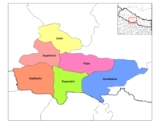
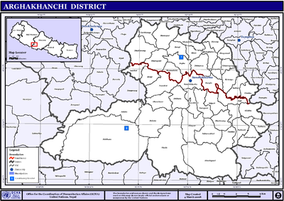
Geography
Arghakhanchi lies between 27'45"N and 28'6"N latitude, and 80'45"E to 83'23"E longitude. It covers 1,193 km². 68% of the district is in the mountainous Mahabharat Range and the rest is in the Siwalik HillsSiwalik Hills
The Sivalik hills is a mountain range of the outer Himalayas also known as Manak Parbat in ancient times. Shivalik literally means 'tresses of Shiva’. This range is about long enclosing an area that starts almost from the Indus and ends close to the Brahmaputra, with a gap of about between the...
. Elevations range from 305–2575 m above sea level and about 40% of the total area is forested.
Arghakanchi is surrounded by Lumbini Zone's Palpa district
Palpa District
-Village Development Committee :*Archale*Argali*Bahadurpur*Bakamalang*Baldengadhi*Bandi Pokhara*Barangdi old name archale barangdi name came from barandi khola on the bank of this river the famous rani mahal is situated*Bhairabsthan*Bhuwan...
to the east, Gulmi
Gulmi District
Gulmi District of 296,654. It is famous for coffee farming. Ruru, a Holy Place now also known as Ridi,is a market centre,where many of the tamples are situated.Maghe sankranti and other festivals are celebrated here. Many local as well as foreign tourists come here to visit the place...
to the north, and by Terai
Terai
The Terai is a belt of marshy grasslands, savannas, and forests located south of the outer foothills of the Himalaya, the Siwalik Hills, and north of the Indo-Gangetic Plain of the Ganges, Brahmaputra and their tributaries. The Terai belongs to the Terai-Duar savanna and grasslands ecoregion...
districts Kapilbastu and Rupandehi to the south. To the west are Rapti Zone
Rapti Zone
Rapti Anchal in the Mid-Western Development Region of Nepal. It is named after the West Rapti River which drains Rolpa, Pyuthan and part of Dang district. The remainder of Dang and part of Salyan are drained by the Babai. The remainder of Salyan and all of Rukum are drained by the Bheri.The...
's Pyuthan
Pyuthan District
Pyuthan District of 212,484. Pyuthan Khalanga is the district's administrative center.-Geography:Pyuthan borders Dang Deukhuri District to the southwest along the crest of the Mahabharat Range and extends about 50 km northeast through the Middle Hills to a 3,000+ meter ridge that is both...
and Dang districts.
The extreme western part of the district borders Jhimruk Khola, a tributary of the Rapti
West Rapti River
Not to be confused with the East Rapti in Chitwan Valley some to the east, this Rapti drains Rapti Zone in Mid-Western Region, Nepal, then Awadh and Purvanchal regions of Uttar Pradesh state, India before joining the Ghaghara a major left bank tributary of the Ganges.The West Rapti is notable for...
. Otherwise the Mahabharat Range is the main hydrographic boundary where northern slopes drain into the Kaligandaki River and everything south of the crest drains into minor drainages ultimately crossing into Uttar Pradesh
Uttar Pradesh
Uttar Pradesh abbreviation U.P. , is a state located in the northern part of India. With a population of over 200 million people, it is India's most populous state, as well as the world's most populous sub-national entity...
, India. Streams in the district include Bangikhola, Bangsari Khola, Mathurabesi Khola, Banganga Khola, Durgakhola, Sitakhola, Khakabesi Khola, Rangsing Khola, Ratne Khola, Jhimruk Khola and Khankbesi Khola etc. Lakes in the district are Thada lake and Sengleng lake.
Towns and villages
Adguri
Adguri is a small town in Arghakhanchi District in the Lumbini Zone of southern Nepal. At the time of the 1991 Nepal census it had a population of 4,174 and had 804 houses in the village....
, Argha
Argha
Argha is a town in Arghakhanchi District in the Lumbini Zone of southern Nepal. At the time of the 1991 Nepal census it had a population of 8,248 and had 1712 houses in the village....
, Arghatosh, Asurkot
Asurkot
Asurkot is a village in Arghakhanchi District in the Lumbini Zone of southern Nepal. At the time of the 1991 Nepal census it had a population of 2,500 and had 434 houses in the village....
, Balkot
Balkot, Lumbini
Balkot is a small town in Arghakhanchi District in the Lumbini Zone of southern Nepal. At the time of the 1991 Nepal census it had a population of 4,283 and had 858 houses in the village....
, Bangi
Bangi, Nepal
Bangi is a small town in Arghakhanchi District in the Lumbini Zone of southern Nepal. At the time of the 1991 Nepal census it had a population of 4,171 and had 858 houses in the village....
, Bhagawati
Bhagavathi, Nepal
Bhagavathi is a small town in Arghakhanchi District in the Lumbini Zone of southern Nepal. At the time of the 1991 Nepal census it had a population of 4,418 and had 842 houses in the town.-References:...
, Chhatraganj
Chhatraganj
Chhatraganj is a village in Arghakhanchi District in the Lumbini Zone of southern Nepal. At the time of the 1991 Nepal census it had a population of 2,927 and had 578 houses in the town. There is a high school named Shree Sarbajanik Ma Vi that was established in 1958 . It celebrated its golden...
, Chidika
Chidika
Chidika is a small town in Arghakhanchi District in the Lumbini Zone of southern Nepal. At the time of the 1991 Nepal census it had a population of 3,578 and had 697 houses in the town....
, Dhakawang
Dhakawang
Dhakawang is a small town in Arghakhanchi District in the Lumbini Zone of southern Nepal. At the time of the 1991 Nepal census it had a population of 6,229 and had 1165 houses in the town....
, Dhanchaur
Dhanchaur
Dhanchour is a small town in Arghakhanchi District in the Lumbini Zone of southern Nepal. At the time of the 1991 Nepal census it had a population of 3,529 and had 648 houses in the town....
, Dharapani
Dharapani, Lumbini
Dharapani is a small town in Arghakhanchi District in the Lumbini Zone of southern Nepal. At the time of the 1991 Nepal census it had a population of 5,236 and had 1020 houses in the town....
, Dhatiwang
Dhatiwang
Dhatiwang is a village in Arghakhanchi District in the Lumbini Zone of southern Nepal. At the time of the 1991 Nepal census it had a population of 2,100 and had 391 houses in the village....
, Dhikura
Dhikura
Dhikura is a small town in Arghakhanchi District in the Lumbini Zone of southern Nepal. At the time of the 1991 Nepal census it had a population of 3,996 and had 728 houses in the town....
, Dibharna
Dibharna
Dibharna is a small town in Arghakhanchi District in the Lumbini Zone of southern Nepal. At the time of the 1991 Nepal census it had a population of 4,490 and had 841 houses in the town....
, Gorkhunga
Gorkhunga
Gorkhunga is a village in Arghakhanchi District in the Lumbini Zone of southern Nepal. At the time of the 1991 Nepal census it had a population of 2,918 and had 605 houses in the village....
, Hansapur
Hansapur, Lumbini
Hansapur is a small town in Arghakhanchi District in the Lumbini Zone of southern Nepal. At the time of the 1991 Nepal census it had a population of 7,407 and had 1458 houses in the town.-References:...
, Jukena
Jukena
Jukena is a small town in Arghakhanchi District in the Lumbini Zone of southern Nepal. At the time of the 1991 Nepal census it had a population of 6,144 and had 1083 houses in the town....
, Jaluke, Keemadada
Keemadada
Keemadada is a small town in Arghakhanchi District in the Lumbini Zone of southern Nepal. At the time of the 1991 Nepal census it had a population of 5,430 and had 1085 houses in the town....
, Kerunga
Kerunga
Kerunga is a small town in Arghakhanchi District in the Lumbini Zone of southern Nepal. At the time of the 1991 Nepal census it had a population of 4,650 and had 965 houses in the town....
, Khan
Khan, Nepal
Khan is a small town in Arghakhanchi District in the Lumbini Zone of southern Nepal. At the time of the 1991 Nepal census it had a population of 3,925 and had 760 houses in the town....
, Khanchikot
Khanchikot
Khanchikot is a VDC in Arghakhanchi District. The district lies in the Lumbini Zone of Western Nepal. During 1991 Nepal census it was estimated to have a total population of 4,628 individuals and had 930 houses....
, Khandaha
Khandaha
Khandaha is a small town in Arghakhanchi District in the Lumbini Zone of southern Nepal. At the time of the 1991 Nepal census it had a population of 3,206 and had 659 houses in the town....
, Khidim
Khidim
Khidim is a small town in Arghakhanchi District in the Lumbini Zone of southern Nepal. At the time of the 1991 Nepal census it had a population of 3,394 and had 654 houses in the town.-References:...
, Khilji
Khilji, Nepal
Khilji is a village in Arghakhanchi District in the Lumbini Zone of southern Nepal. At the time of the 1991 Nepal census it had a population of 2,883 and had 546 houses in the village.It is one of the most decveloped v.d.C of this district. Most of the people are engaged in job such as...
, Maidan
Maidan, Nepal
Maidan is a village development committee in Arghakhanchi District in the Lumbini Zone of southern Nepal. At the time of the 1991 Nepal census it had a population of 4,474 and had 792 houses in the village....
, Mareng
Mareng
Mareng is a village development committee in the Arghakhanchi District of the Lumbini Zone of southern Nepal. At the time of the 1991 Nepal census it had a population of 4,102 and had 782 houses in the town....
, Narapani
Narapani
Narapani is a small town in Arghakhanchi District in the Lumbini Zone of southern Nepal. At the time of the 1991 Nepal census it had a population of 4,664 and had 873 houses in the town....
, Nuwakot
Nuwakot, Arghakhanchi
Nuwakot is a small town in Arghakhanchi District in the Lumbini Zone of southern Nepal. At the time of the 1991 Nepal census it had a population of 6,127 and had 1158 houses in the town....
, Pali
Pali, Nepal
Pali is a small town in Arghakhanchi District in the Lumbini Zone of southern Nepal. At the time of the 1991 Nepal census it had a population of 4,016 and had 804 houses in the town....
, Parena
Parena
Parena is a small town in Arghakhanchi District in the Lumbini Zone of southern Nepal. At the time of the 1991 Nepal census it had a population of 2,598 and had 475 houses in the town....
, Pathauti
Pathauti
Pathauti is a small town in Arghakhanchi District in the Lumbini Zone of southern Nepal. At the time of the 1991 Nepal census it had a population of 3,194 and had 614 houses in the town....
, Pathona
Pathona
Pathona is a small town in Arghakhanchi District in the Lumbini Zone of southern Nepal....
, Pokharathok
Pokharathok, Arghakhanchi
Pokharathok is a small town in Arghakhanchi District in the Lumbini Zone of southern Nepal. At the time of the 1991 Nepal census it had a population of 3,373 and had 622 houses in the town.-References:...
, Sandhikharka
Sandhikharka
Sandhikharka is the headquarters of Arghakhanchi District in the Lumbini Zone of Nepal. It is located in a remote area of central Nepal, 380 km southwest of Nepal's capital of Kathmandu. Due to a high literacy rate, Sandhikharka once attracted people from outside Arghakhanchi District to...
, Siddhara
Siddhara
Siddhara is a small town in Arghakhanchi District in the Lumbini Zone of southern Nepal. At the time of the 1991 Nepal census it had a population of 7,126 and had 1182 houses in the town....
, Simalapani
Simalapani
Simalapani is a small town in Arghakhanchi District in the Lumbini Zone of southern Nepal. At the time of the 1991 Nepal census it had a population of 4,387 and had 791 houses in the town....
, Sitapur
Sitapur, Arghakhanchi
Sitapur is a small town in Arghakhanchi District in the Lumbini Zone of southern Nepal....
, Subarnakhal
Subarnakhal
Subarnakhal is a small town in Arghakhanchi District in the Lumbini Zone of southern Nepal. At the time of the 1991 Nepal census it had a population of 3,020 and had 556 houses in the town....
, Thada
Thada
Thada is a small town in Arghakhanchi District in the Lumbini Zone of southern Nepal. At the time of the 1991 Nepal census it had a population of 7,765 and had 1468 houses in the town....
, Thulo Pokhara
Thulo Pokhara
Thulo Pokhara is a small town in Arghakhanchi District in the Lumbini Zone of southern Nepal. At the time of the 1991 Nepal census it had a population of 3,469 and had 711 houses in the town....