

Protected areas of Michigan
Encyclopedia
The protected areas of Michigan come in an array of different types and levels of protection. Michigan
has five units of the National Park Service
system. There are 14 federal wilderness areas; the majority of these are also tribal-designated wildernesses. It has one of the largest state forest
systems as well having four national forest
s. The state maintains a large state park
system and there are also regional park
s, and county, township and city parks. Still other parks on land and in the Great Lakes
are maintained by other governmental bodies.
, Isle Royale National Park
as well as two national lakeshores, Pictured Rocks National Lakeshore
and Sleeping Bear Dunes National Lakeshore
. There is also River Raisin National Battlefield Park
, the Keweenaw National Historical Park
and the Father Marquette National Memorial
, although the latter is managed by the Michigan state park system for the national government.
Michigan has four national forest
s: two in the Lower Peninsula
, Huron National Forest and Manistee National Forest as well as two in the Upper Peninsula
, Ottawa National Forest
and Hiawatha National Forest
. The U.S. Forest Service owns 2.8 million acres (11,000 km²) in these forests out of the designated areas which total 4.8 million acres (19,000 km²) when including private inholding
s. Several areas in the forests are designated wilderness and one area, Grand Island is a National Recreation Area
. All sixteen National Wild and Scenic River
s in Michigan are managed by the Forest Service. (See List of National Wild and Scenic Rivers#Michigan)
 Fifteen federal wildernesses in Michigan cover 249,218 acres (1,009 km²):
There are ten National Wildlife Refuge
s covering 113,639 acres (460 km²) in the state. These include the first international refuge between the United States and Canada
, the Detroit River International Wildlife Refuge
. (See List of National Wildlife Refuges#Michigan)
The Thunder Bay National Marine Sanctuary and Underwater Preserve preserves an area of 448 square miles (1160 km²) with 120 shipwrecks in Lake Huron
and is managed jointly by the state and the National Oceanic and Atmospheric Administration
.
s; 19 state recreation areas, 6 state forests, and 5 state scenic sites. They also manage the Father Marquette National Memorial
for the federal government. The MIDNR owns 4.5 million acres (18,000 km²) of land, 6 million acres (24,000 km²) of mineral rights, and manages 25 million acres (101,000 km²) of Great Lakes' bottomlands. Most of the protected lands, almost 4 million acres (16,000 km²) are in the state forest system. State parks range in size from 31 acres (0.25 km²) (Tricentennial State Park) to 60,000 acres (243 km²) (Porcupine Mountains State Park).
The state manages a number of state game areas primarily for hunting
. Other areas include state wildlife areas, state wildlife research areas, and wildlife research stations.
systems like the 24,000 acre (97 km²) Huron-Clinton Metroparks
. Michigan has county parks, township parks and at least one soil conservation district park among other types. Two state parks, Van Buren Trail State Park
and Kal-Haven Trail
are managed on the county level. Other protected areas include nature study areas owned by several colleges and universities throughout the state. The University of Michigan, for example, has the 350 acres (141.6 ha) Matthaei Botanical Gardens, 350 acres (141.6 ha) Nichols Arboretum, 777 acres (314.4 ha) Stinchfield Woods, and the University of Michigan Biological Station
with 10000 acres (4,046.9 ha) at Douglas Lake and 3200 acres (1,295 ha) on Sugar Island. Michigan State University has the 4600 acres (1,861.6 ha) Kellogg Biological Station
.
Michigan
Michigan is a U.S. state located in the Great Lakes Region of the United States of America. The name Michigan is the French form of the Ojibwa word mishigamaa, meaning "large water" or "large lake"....
has five units of the National Park Service
National Park Service
The National Park Service is the U.S. federal agency that manages all national parks, many national monuments, and other conservation and historical properties with various title designations...
system. There are 14 federal wilderness areas; the majority of these are also tribal-designated wildernesses. It has one of the largest state forest
State forest
A state forest is a forest that is administered or protected by some agency of a sovereign state.The precise application of the term varies by jurisdiction...
systems as well having four national forest
United States National Forest
National Forest is a classification of federal lands in the United States.National Forests are largely forest and woodland areas owned by the federal government and managed by the United States Forest Service, part of the United States Department of Agriculture. Land management of these areas...
s. The state maintains a large state park
State park
State parks are parks or other protected areas managed at the federated state level within those nations which use "state" as a political subdivision. State parks are typically established by a state to preserve a location on account of its natural beauty, historic interest, or recreational...
system and there are also regional park
Regional park
Regional park is a term used for an area of land preserved on account of its natural beauty, historic interest, recreational use or other reason, and under the administration of a form of local government.-Definition:...
s, and county, township and city parks. Still other parks on land and in the Great Lakes
Great Lakes
The Great Lakes are a collection of freshwater lakes located in northeastern North America, on the Canada – United States border. Consisting of Lakes Superior, Michigan, Huron, Erie, and Ontario, they form the largest group of freshwater lakes on Earth by total surface, coming in second by volume...
are maintained by other governmental bodies.
Federal level
Michigan contains a number of different types of federally managed lands. There is one national parkNational park
A national park is a reserve of natural, semi-natural, or developed land that a sovereign state declares or owns. Although individual nations designate their own national parks differently A national park is a reserve of natural, semi-natural, or developed land that a sovereign state declares or...
, Isle Royale National Park
Isle Royale National Park
Isle Royale National Park is a U.S. National Park in the state of Michigan. Isle Royale, the largest island in Lake Superior, is over 45 miles in length and 9 miles wide at its widest point. The park is made of Isle Royale itself and approximately 400 smaller islands, along with any submerged...
as well as two national lakeshores, Pictured Rocks National Lakeshore
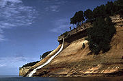
Pictured Rocks National Lakeshore
Pictured Rocks National Lakeshore is a U.S. National Lakeshore on the shore of Lake Superior in the Upper Peninsula of Michigan, United States. It extends for 42 miles along the shore and covers...
and Sleeping Bear Dunes National Lakeshore
Sleeping Bear Dunes National Lakeshore
Sleeping Bear Dunes National Lakeshore is a United States National Lakeshore located along the northwest coast of the Lower Peninsula of Michigan in Leelanau County and Benzie County....
. There is also River Raisin National Battlefield Park
River Raisin National Battlefield Park
The River Raisin National Battlefield Park was established as the 393rd unit of the United States National Park Service under Title VII of the Omnibus Public Land Management Act, which was signed into law on March 30, 2009. The park is located in the city of Monroe in Monroe County, Michigan. It...
, the Keweenaw National Historical Park
Keweenaw National Historical Park
Keweenaw National Historical Park is a unit of the U.S. National Park Service. Established in 1992, the park celebrates the life and history of the Keweenaw Peninsula in the Upper Peninsula of the U.S. state of Michigan...
and the Father Marquette National Memorial
Father Marquette National Memorial
Father Marquette National Memorial pays tribute to the life and work of Jacques Marquette, French priest and explorer. The memorial is located in Straits State Park near St. Ignace in the modern-day U.S. state of Michigan, where he founded a Jesuit mission in 1671 and was buried in 1678...
, although the latter is managed by the Michigan state park system for the national government.
Michigan has four national forest
United States National Forest
National Forest is a classification of federal lands in the United States.National Forests are largely forest and woodland areas owned by the federal government and managed by the United States Forest Service, part of the United States Department of Agriculture. Land management of these areas...
s: two in the Lower Peninsula
Lower Peninsula of Michigan
The Lower Peninsula of Michigan is the southern of the two major landmasses of the U.S. state of Michigan. It is surrounded by water on all sides except its southern border, which it shares with Ohio and Indiana. Geographically, the Lower Peninsula has a recognizable shape that many people...
, Huron National Forest and Manistee National Forest as well as two in the Upper Peninsula
Upper Peninsula of Michigan
The Upper Peninsula of Michigan is the northern of the two major land masses that make up the U.S. state of Michigan. It is commonly referred to as the Upper Peninsula, the U.P., or Upper Michigan. It is also known as the land "above the Bridge" linking the two peninsulas. The peninsula is bounded...
, Ottawa National Forest
Ottawa National Forest
The Ottawa National Forest is a 1.0 million acre national forest in the Upper Peninsula of the U.S. state of Michigan. It includes much of Gogebic and Ontonagon counties, as well as slices of Iron, Houghton, Baraga, and Marquette counties. The forest is under the jurisdiction of the U.S...
and Hiawatha National Forest
Hiawatha National Forest
Hiawatha National Forest is a National Forest in the Upper Peninsula of the state of Michigan in the United States. Commercial logging is conducted in some areas. The United States Forest Service administers this National Forest; it is physically divided into two subunits, commonly called the...
. The U.S. Forest Service owns 2.8 million acres (11,000 km²) in these forests out of the designated areas which total 4.8 million acres (19,000 km²) when including private inholding
Inholding
An inholding is privately owned land inside the boundary of a national park, national forest, state park, or similar publicly owned, protected area...
s. Several areas in the forests are designated wilderness and one area, Grand Island is a National Recreation Area
National Recreation Area
National Recreation Area is a designation for a protected area in the United States, often centered on large reservoirs and emphasizing water-based recreation for a large number of people. The first National Recreation Area was the Boulder Dam Recreation Area...
. All sixteen National Wild and Scenic River
National Wild and Scenic River
National Wild and Scenic River is a designation for certain protected areas in the United States.The National Wild and Scenic Rivers Act was an outgrowth of the recommendations of a Presidential commission, the Outdoor Recreation Resources Review Commission...
s in Michigan are managed by the Forest Service. (See List of National Wild and Scenic Rivers#Michigan)
- One is almost congruent with Isle Royale National Park
- One, Beaver Basin, is managed by the National Park Service and is located within Pictured Rocks National Lakeshore.
- Three are managed by the U.S. Fish & Wildlife Service:
- Michigan Islands Wilderness
- Huron Islands Wilderness
- Seney Wilderness
- Ten are located in National Forests and are managed jointly by the U.S. Forest Service and the Great Lakes Indian Fish & Wildlife CommissionGreat Lakes Indian Fish & Wildlife CommissionThe Great Lakes Indian Fish & Wildlife Commission is an inter-tribal, co-management agency committed to the implementation of off-reservation treaty rights on behalf of its eleven-member Ojibwa tribes...
of Chippewa Indians:- McCormick WildernessMcCormick WildernessThe McCormick Wilderness is a United States Wilderness Area located in the Upper Peninsula of Michigan. It covers an area of about and is located east of the Baraga-Marquette county line...
- Sturgeon River Gorge WildernessSturgeon River Gorge WildernessThe Sturgeon River Gorge Wilderness is a unit within the Ottawa National Forest. It is located in Baraga County and Houghton County within the U.S. state of Michigan. The wilderness is accessible from M-28, which runs south of the unit in a west-to-east direction...
- Sylvania WildernessSylvania WildernessSylvania Wilderness is an protected area located a few miles west of Watersmeet, Michigan. Sylvania is located entirely within the bounds of the Ottawa National Forest, and is currently being managed as a wilderness area as part of the National Wilderness Preservation System by the U.S. Forest...
- Big Island Lake WildernessBig Island Lake WildernessBig Island Lake Wilderness is a remote protected area in the Munising Ranger District of the Hiawatha National Forest in the Upper Peninsula in the state of Michigan in the United States. The wilderness area is located about one-half mile northwest of the community of Steuben and northwest of...
- Delirium WildernessDelirium WildernessDelirium Wilderness is a wilderness area in Chippewa County, within the Hiawatha National Forest in the U.S. state of Michigan.The Wilderness is forested, flat, and rolling, often characterized as a swamp, with elevations ranging from 590 to 890 feet...
- Horseshoe Bay WildernessHorseshoe Bay WildernessThe Horseshoe Bay Wilderness is a wilderness area in the U.S. state of Michigan. It borders Horseshoe Bay, a shallow bay that is part of the extreme northwest corner of Lake Huron adjacent to the Straits of Mackinac...
- Mackinac WildernessMackinac WildernessThe Mackinac Wilderness is a unit within the Hiawatha National Forest. It is located in Mackinac County, Michigan. The wilderness is accessible from M-123, which borders the unit. The nearest town is Moran, Michigan....
- Rock River Canyon WildernessRock River Canyon WildernessThe Rock River Canyon Wilderness is a unit within the Hiawatha National Forest. It is located in Alger County, Michigan. The wilderness is accessible from M-94, which runs south of the unit in a west-to-east direction...
- Round Island Wilderness
- Nordhouse Dunes WildernessNordhouse Dunes WildernessThe Nordhouse Dunes Wilderness is a listed wilderness area within the Manistee National Forest. It is located north of Ludington, Michigan, and is best known for its 4 miles of undeveloped Lake Michigan shoreline.-Geology:...
- McCormick Wilderness
There are ten National Wildlife Refuge
National Wildlife Refuge
National Wildlife Refuge is a designation for certain protected areas of the United States managed by the United States Fish and Wildlife Service. The National Wildlife Refuge System is the world's premiere system of public lands and waters set aside to conserve America's fish, wildlife and plants...
s covering 113,639 acres (460 km²) in the state. These include the first international refuge between the United States and Canada
Canada
Canada is a North American country consisting of ten provinces and three territories. Located in the northern part of the continent, it extends from the Atlantic Ocean in the east to the Pacific Ocean in the west, and northward into the Arctic Ocean...
, the Detroit River International Wildlife Refuge
Detroit River International Wildlife Refuge
The Detroit River International Wildlife Refuge is the only international wildlife refuge in North America. It was established in 2001 and is managed jointly by the United States Fish and Wildlife Service and the Canadian Wildlife Service. The refuge is located along the western coast of Lake...
. (See List of National Wildlife Refuges#Michigan)
The Thunder Bay National Marine Sanctuary and Underwater Preserve preserves an area of 448 square miles (1160 km²) with 120 shipwrecks in Lake Huron
Lake Huron
Lake Huron is one of the five Great Lakes of North America. Hydrologically, it comprises the larger portion of Lake Michigan-Huron. It is bounded on the east by the Canadian province of Ontario and on the west by the state of Michigan in the United States...
and is managed jointly by the state and the National Oceanic and Atmospheric Administration
National Oceanic and Atmospheric Administration
The National Oceanic and Atmospheric Administration , pronounced , like "noah", is a scientific agency within the United States Department of Commerce focused on the conditions of the oceans and the atmosphere...
.
State level
The Michigan Department of Natural Resources manages state protected areas. These include 78 state parkState park
State parks are parks or other protected areas managed at the federated state level within those nations which use "state" as a political subdivision. State parks are typically established by a state to preserve a location on account of its natural beauty, historic interest, or recreational...
s; 19 state recreation areas, 6 state forests, and 5 state scenic sites. They also manage the Father Marquette National Memorial
Father Marquette National Memorial
Father Marquette National Memorial pays tribute to the life and work of Jacques Marquette, French priest and explorer. The memorial is located in Straits State Park near St. Ignace in the modern-day U.S. state of Michigan, where he founded a Jesuit mission in 1671 and was buried in 1678...
for the federal government. The MIDNR owns 4.5 million acres (18,000 km²) of land, 6 million acres (24,000 km²) of mineral rights, and manages 25 million acres (101,000 km²) of Great Lakes' bottomlands. Most of the protected lands, almost 4 million acres (16,000 km²) are in the state forest system. State parks range in size from 31 acres (0.25 km²) (Tricentennial State Park) to 60,000 acres (243 km²) (Porcupine Mountains State Park).
The state manages a number of state game areas primarily for hunting
Hunting
Hunting is the practice of pursuing any living thing, usually wildlife, for food, recreation, or trade. In present-day use, the term refers to lawful hunting, as distinguished from poaching, which is the killing, trapping or capture of the hunted species contrary to applicable law...
. Other areas include state wildlife areas, state wildlife research areas, and wildlife research stations.
- List of Michigan state parks
- List of Michigan state forests
- List of Michigan state game areas
- List of U.S. state and tribal wilderness areas
Local levels
A number of different local government bodies operate parks and protected areas. These include city parks which may be no more than a green space in a city to large regional parkRegional park
Regional park is a term used for an area of land preserved on account of its natural beauty, historic interest, recreational use or other reason, and under the administration of a form of local government.-Definition:...
systems like the 24,000 acre (97 km²) Huron-Clinton Metroparks
Huron-Clinton Metroparks
The Huron-Clinton Metroparks system is a regional park system in Metro Detroit in the U.S. state of Michigan. The park system includes 13 parks totalling arranged along the Huron River and Clinton River forming a partial ring around the metro area. Plans are in development to finish the ring by...
. Michigan has county parks, township parks and at least one soil conservation district park among other types. Two state parks, Van Buren Trail State Park
Van Buren Trail State Park
Van Buren Trail State Park, also known as Trail State Park, is an unimproved rail trail running along a former railroad right-of-way between Hartford, Michigan to just south of South Haven, Michigan in Van Buren County. It is long and mostly used by horse trail riders in the summer and...
and Kal-Haven Trail
Kal-Haven Trail
The Kal-Haven Trail, formally known as the Kal-Haven Trail Sesquicentennial State Park, is a rail trail that originally ran 33.5 miles between South Haven, Michigan, to a point just west of the city of Kalamazoo, Michigan, where there is a trailhead...
are managed on the county level. Other protected areas include nature study areas owned by several colleges and universities throughout the state. The University of Michigan, for example, has the 350 acres (141.6 ha) Matthaei Botanical Gardens, 350 acres (141.6 ha) Nichols Arboretum, 777 acres (314.4 ha) Stinchfield Woods, and the University of Michigan Biological Station
University of Michigan Biological Station
The University of Michigan Biological Station is a research and teaching facility operated by the University of Michigan. It is located on the south shore of Douglas Lake in Cheboygan County, Michigan. The station consists of 10,000 acres of land near Pellston, Michigan in the northern Lower...
with 10000 acres (4,046.9 ha) at Douglas Lake and 3200 acres (1,295 ha) on Sugar Island. Michigan State University has the 4600 acres (1,861.6 ha) Kellogg Biological Station
Kellogg Biological Station
Kellogg Biological Station , Michigan State University's largest off-campus education complex, is located in Hickory Corners, Michigan . Many of the facilities there were originally built by Will Keith Kellogg of Kellogg's cereal, after whom the station is named...
.