
Presidential Range
Encyclopedia
The Presidential Range is a mountain range
located in the White Mountains
of the U.S. state
of New Hampshire
. Containing the highest peaks of the Whites
, its most notable summits
are named for American
Presidents, followed by prominent public figures of the 18th and 19th centuries.
Mt. Washington
, long home of the highest winds recorded on the surface of the Earth at 231 mi/h, is the tallest (at 6288 ft (1,917 m)). The range is almost entirely in Coos County
.
) named for the first president, the second tallest (Mt. Adams
) for the second president, and so on. However due to a surveying error, Mt. Monroe
is actually 22 feet (6.7 m) taller than Mt. Madison
, which is not the correct order of presidents.
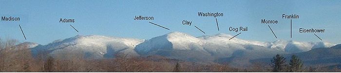
Among the range's most notable summits, in sequence from southwest to northeast, are:
Mt. Adams has, besides its main summit, four subsidiary peaks that are also commonly recognized by name; two, Sam Adams and John Quincy Adams, are listed above. The third and fourth are:
The summits marked with an asterisk (*) are included on the peak bagging
list of 4,000-foot and higher
mountains in New Hampshire; the others are excluded, in some cases because of lesser height and in others because of more technical criteria.
 Aside from the notable summits, the geological Presidential Range contains a number of additional named peaks. Several of these peaks, drained on their west faces by the Dry River
, are less accessible than the main and most visited ridge of the range.
Subsidiary peaks of Mount Washington:
North from Mount Washington:
South from Mount Washington:
The summits marked with an asterisk (*) are included on the peak-bagging list of 4,000-foot and higher
mountains in New Hampshire; the others are excluded, in some cases because of lesser height and in others because of more technical criteria.
and Androscoggin
rivers into the Atlantic Ocean
on the coast of Maine
, from drainage into the Israel
and Ammonoosuc
rivers, thence into the Connecticut River
, and thence into Long Island Sound
.
is a hike
which traverses each major summit along the 19 miles (30.6 km) Presidential ridge, encompassing at least 8,500 feet in elevation gain. It can be done in a single day in summer, but during winter it is generally a two- to four-day venture, and even so several rescues of lost, overdue or injured hikers have occurred during range traverses.
Mountain range
A mountain range is a single, large mass consisting of a succession of mountains or narrowly spaced mountain ridges, with or without peaks, closely related in position, direction, formation, and age; a component part of a mountain system or of a mountain chain...
located in the White Mountains
White Mountains (New Hampshire)
The White Mountains are a mountain range covering about a quarter of the state of New Hampshire and a small portion of western Maine in the United States. Part of the Appalachian Mountains, they are considered the most rugged mountains in New England...
of the U.S. state
U.S. state
A U.S. state is any one of the 50 federated states of the United States of America that share sovereignty with the federal government. Because of this shared sovereignty, an American is a citizen both of the federal entity and of his or her state of domicile. Four states use the official title of...
of New Hampshire
New Hampshire
New Hampshire is a state in the New England region of the northeastern United States of America. The state was named after the southern English county of Hampshire. It is bordered by Massachusetts to the south, Vermont to the west, Maine and the Atlantic Ocean to the east, and the Canadian...
. Containing the highest peaks of the Whites
Four-thousand footers
The term Four-Thousand Footers refers to a group of forty-eight mountains in New Hampshire at least 4,000 feet above sea level...
, its most notable summits
Summit (topography)
In topography, a summit is a point on a surface that is higher in elevation than all points immediately adjacent to it. Mathematically, a summit is a local maximum in elevation...
are named for American
United States
The United States of America is a federal constitutional republic comprising fifty states and a federal district...
Presidents, followed by prominent public figures of the 18th and 19th centuries.
Mt. Washington
Mount Washington (New Hampshire)
Mount Washington is the highest peak in the Northeastern United States at , famous for dangerously erratic weather. For 76 years, a weather observatory on the summit held the record for the highest wind gust directly measured at the Earth's surface, , on the afternoon of April 12, 1934...
, long home of the highest winds recorded on the surface of the Earth at 231 mi/h, is the tallest (at 6288 ft (1,917 m)). The range is almost entirely in Coos County
Coos County, New Hampshire
-National protected areas:*Umbagog National Wildlife Refuge *Silvio O. Conte National Fish and Wildlife Refuge *White Mountain National Forest -Demographics:...
.
Notable summits
The highest mountains in the Presidential Range are named principally for U.S. presidents, with the tallest mountain (Mt. WashingtonMount Washington (New Hampshire)
Mount Washington is the highest peak in the Northeastern United States at , famous for dangerously erratic weather. For 76 years, a weather observatory on the summit held the record for the highest wind gust directly measured at the Earth's surface, , on the afternoon of April 12, 1934...
) named for the first president, the second tallest (Mt. Adams
Mount Adams (New Hampshire)
Mount Adams, elevation above sea level, is a mountain in New Hampshire, the second highest peak in the Northeast United States after its nearby neighbor, Mt. Washington. Located in the northern Presidential Range, Mount Adams was named after John Adams, the second president of the United States....
) for the second president, and so on. However due to a surveying error, Mt. Monroe
Mount Monroe
Mount Monroe is the highest peak south of Mount Washington in the Presidential Range of New Hampshire. It is the fourth highest mountain on the 4000 footers list for New Hampshire. The Lakes of the Clouds, and its AMC hut, lie nestled at the col between Mount Monroe and neighboring Mount...
is actually 22 feet (6.7 m) taller than Mt. Madison
Mount Madison
Mount Madison is a mountain in the Presidential Range of New Hampshire in the United States. It is named after the fourth U.S. President, James Madison....
, which is not the correct order of presidents.
Among the range's most notable summits, in sequence from southwest to northeast, are:
- Mt. Webster — after Daniel WebsterDaniel WebsterDaniel Webster was a leading American statesman and senator from Massachusetts during the period leading up to the Civil War. He first rose to regional prominence through his defense of New England shipping interests...
- Mt. JacksonMount Jackson (New Hampshire)Mount Jackson is a mountain located in Coos County, New Hampshire. The mountain is named after Charles Thomas Jackson, New Hampshire's state geologist in the 19th century, and is part of the Presidential Range of the White Mountains. Mt...
* — after Charles Thomas JacksonCharles Thomas JacksonCharles Thomas Jackson was an American physician and scientist who was active in medicine, chemistry, mineralogy, and geology.- Life and work :...
(19th c. geologist) - Mt. PierceMount Pierce (New Hampshire)Mount Pierce is a mountain in the Presidential Range in the White Mountains of New Hampshire that is approximately 4,310 feet high...
* — after Franklin PierceFranklin PierceFranklin Pierce was the 14th President of the United States and is the only President from New Hampshire. Pierce was a Democrat and a "doughface" who served in the U.S. House of Representatives and the Senate. Pierce took part in the Mexican-American War and became a brigadier general in the Army...
(formerly Mt. Clinton — after DeWitt ClintonDeWitt ClintonDeWitt Clinton was an early American politician and naturalist who served as United States Senator and the sixth Governor of New York. In this last capacity he was largely responsible for the construction of the Erie Canal...
) - Mt. EisenhowerMount EisenhowerMount Eisenhower is a mountain in the Presidential Range in the White Mountains of New Hampshire approximately high. Named after President Dwight D. Eisenhower, its summit offers a 360° view of New Hampshire's mountains. It is inaccessible by road.The Crawford Path, carrying the Appalachian...
* — after Dwight Eisenhower - Mt. FranklinMount Franklin (New Hampshire)Mount Franklin is a mountain located in Coos County, New Hampshire. The mountain is named after Benjamin Franklin, and is part of the Presidential Range of the White Mountains. Note that Ben Franklin was not a president. Mount Franklin is flanked to the northeast by Mount Monroe, and to the...
— after Benjamin FranklinBenjamin FranklinDr. Benjamin Franklin was one of the Founding Fathers of the United States. A noted polymath, Franklin was a leading author, printer, political theorist, politician, postmaster, scientist, musician, inventor, satirist, civic activist, statesman, and diplomat... - Mt. MonroeMount MonroeMount Monroe is the highest peak south of Mount Washington in the Presidential Range of New Hampshire. It is the fourth highest mountain on the 4000 footers list for New Hampshire. The Lakes of the Clouds, and its AMC hut, lie nestled at the col between Mount Monroe and neighboring Mount...
* — after James MonroeJames MonroeJames Monroe was the fifth President of the United States . Monroe was the last president who was a Founding Father of the United States, and the last president from the Virginia dynasty and the Republican Generation... - Mt. WashingtonMount Washington (New Hampshire)Mount Washington is the highest peak in the Northeastern United States at , famous for dangerously erratic weather. For 76 years, a weather observatory on the summit held the record for the highest wind gust directly measured at the Earth's surface, , on the afternoon of April 12, 1934...
* — after George WashingtonGeorge WashingtonGeorge Washington was the dominant military and political leader of the new United States of America from 1775 to 1799. He led the American victory over Great Britain in the American Revolutionary War as commander-in-chief of the Continental Army from 1775 to 1783, and presided over the writing of...
(a general at time of naming, and only later a president) - Mt. ClayMount ClayMount Clay is a peak located in Thompson and Meserve's Purchase in Coos County in the Presidential Range of the White Mountains of New Hampshire...
— after Henry ClayHenry ClayHenry Clay, Sr. , was a lawyer, politician and skilled orator who represented Kentucky separately in both the Senate and in the House of Representatives...
(State changed name to Mt. Reagan after Ronald ReaganRonald ReaganRonald Wilson Reagan was the 40th President of the United States , the 33rd Governor of California and, prior to that, a radio, film and television actor....
; U.S. government still recognizes Clay name) - Mt. JeffersonMount Jefferson (New Hampshire)Mount Jefferson is located in Coos County, New Hampshire, and is the third highest mountain in the state. The mountain is named after Thomas Jefferson, the third president of the United States, and is part of the Presidential Range of the White Mountains...
* — after Thomas JeffersonThomas JeffersonThomas Jefferson was the principal author of the United States Declaration of Independence and the Statute of Virginia for Religious Freedom , the third President of the United States and founder of the University of Virginia... - Mt. Sam Adams — after Samuel AdamsSamuel AdamsSamuel Adams was an American statesman, political philosopher, and one of the Founding Fathers of the United States. As a politician in colonial Massachusetts, Adams was a leader of the movement that became the American Revolution, and was one of the architects of the principles of American...
- Mt. AdamsMount Adams (New Hampshire)Mount Adams, elevation above sea level, is a mountain in New Hampshire, the second highest peak in the Northeast United States after its nearby neighbor, Mt. Washington. Located in the northern Presidential Range, Mount Adams was named after John Adams, the second president of the United States....
* — after John AdamsJohn AdamsJohn Adams was an American lawyer, statesman, diplomat and political theorist. A leading champion of independence in 1776, he was the second President of the United States... - Mt. Quincy Adams — after John Quincy AdamsJohn Quincy AdamsJohn Quincy Adams was the sixth President of the United States . He served as an American diplomat, Senator, and Congressional representative. He was a member of the Federalist, Democratic-Republican, National Republican, and later Anti-Masonic and Whig parties. Adams was the son of former...
- Mt. MadisonMount MadisonMount Madison is a mountain in the Presidential Range of New Hampshire in the United States. It is named after the fourth U.S. President, James Madison....
* — after James MadisonJames MadisonJames Madison, Jr. was an American statesman and political theorist. He was the fourth President of the United States and is hailed as the “Father of the Constitution” for being the primary author of the United States Constitution and at first an opponent of, and then a key author of the United...
Mt. Adams has, besides its main summit, four subsidiary peaks that are also commonly recognized by name; two, Sam Adams and John Quincy Adams, are listed above. The third and fourth are:
- Mount Abigail AdamsAbigail AdamsAbigail Adams was the wife of John Adams, who was the second President of the United States, and the mother of John Quincy Adams, the sixth...
(formerly Adams IV) - Adams V
The summits marked with an asterisk (*) are included on the peak bagging
Peak bagging
Peak bagging is an activity in which hillwalkers and mountaineers attempt to reach the summit of some collection of peaks, usually those above some height in a particular region, or having a particular feature.Peak bagging can be distinguished from highpointing...
list of 4,000-foot and higher
Four-thousand footers
The term Four-Thousand Footers refers to a group of forty-eight mountains in New Hampshire at least 4,000 feet above sea level...
mountains in New Hampshire; the others are excluded, in some cases because of lesser height and in others because of more technical criteria.
Other summits
Dry River (New Hampshire)
The Dry River is a 9.0 mile long river in the White Mountains of New Hampshire in the United States. It is a tributary of the Saco River, which flows to the Atlantic Ocean in Maine...
, are less accessible than the main and most visited ridge of the range.
Subsidiary peaks of Mount Washington:
- Ball Crag (6,106 ft)
- Nelson Crag (5,620 ft)
- Boott SpurBoott SpurBoott Spur is a minor peak located in Coos County, New Hampshire. The mountain is named after Dr. Francis Boott , and is part of the Presidential Range of the White Mountains...
(5,500 ft)
North from Mount Washington:
- Mt. Bowman (3,449 ft) (spur of Mount Jefferson)
South from Mount Washington:
- Engine Hill (3,100 ft)
- Maple Mountain (2,601 ft)
- Iron Mountain (2,726 ft)
- Montalban Ridge:
- Mt. IsolationMount IsolationMount Isolation is a mountain located in Coos County, New Hampshire. The mountain is part of the Presidential Range of the White Mountains. Mt. Isolation is the highest peak on the Montalban Ridge which extends south from Boott Spur....
(4,004 ft)* - Mt. DavisMount Davis (New Hampshire)Mount Davis is a mountain located in Coos County, New Hampshire. The mountain is located along Montalban Ridge, a series of summits extending south from Mount Washington in the White Mountains.Mt...
(3,819 ft) - Stairs Mountain (3,463 ft)
- Mt. Resolution (3,415 ft)
- Mt. Isolation
- Bemis Ridge:
- Mt. Crawford (3,119 ft)
- Mt. Hope (2,505 ft)
- Mt. Parker (3,004 ft)
- Mt. Langdon (2,390 ft)
- Mt. Pickering (1,945 ft) (family name of first president of Appalachian Mountain Club)
- Mt. Stanton (1,716 ft)
The summits marked with an asterisk (*) are included on the peak-bagging list of 4,000-foot and higher
Four-thousand footers
The term Four-Thousand Footers refers to a group of forty-eight mountains in New Hampshire at least 4,000 feet above sea level...
mountains in New Hampshire; the others are excluded, in some cases because of lesser height and in others because of more technical criteria.
Watersheds
The Presidentials separate drainage via the SacoSaco River
The Saco River is a river in northeastern New Hampshire and southwestern Maine in the United States. It drains a rural area of of forests and farmlands west and southwest of Portland, emptying into the Atlantic Ocean at Saco Bay, from its source. It supplies drinking water to roughly 250,000...
and Androscoggin
Androscoggin River
The Androscoggin River is a river in the U.S. states of Maine and New Hampshire, in northern New England. It is long and joins the Kennebec River at Merrymeeting Bay in Maine before its water empties into the Gulf of Maine on the Atlantic Ocean. Its drainage basin is in area...
rivers into the Atlantic Ocean
Atlantic Ocean
The Atlantic Ocean is the second-largest of the world's oceanic divisions. With a total area of about , it covers approximately 20% of the Earth's surface and about 26% of its water surface area...
on the coast of Maine
Maine
Maine is a state in the New England region of the northeastern United States, bordered by the Atlantic Ocean to the east and south, New Hampshire to the west, and the Canadian provinces of Quebec to the northwest and New Brunswick to the northeast. Maine is both the northernmost and easternmost...
, from drainage into the Israel
Israel River
The Israel River is a river in the White Mountains of New Hampshire. It arises in the township of Low and Burbank's Grant and runs 24 miles generally northwest along U.S. Highway 2, traversing the towns of Jefferson and Lancaster, before joining the Connecticut River...
and Ammonoosuc
Ammonoosuc River
The Ammonoosuc River is a river, 55 mi long, in northwestern New Hampshire in the United States. It is a tributary of the Connecticut River, which flows to Long Island Sound. "Ammonoosuc" is Abnaki for "small, narrow fishing place"....
rivers, thence into the Connecticut River
Connecticut River
The Connecticut River is the largest and longest river in New England, and also an American Heritage River. It flows roughly south, starting from the Fourth Connecticut Lake in New Hampshire. After flowing through the remaining Connecticut Lakes and Lake Francis, it defines the border between the...
, and thence into Long Island Sound
Long Island Sound
Long Island Sound is an estuary of the Atlantic Ocean, located in the United States between Connecticut to the north and Long Island, New York to the south. The mouth of the Connecticut River at Old Saybrook, Connecticut, empties into the sound. On its western end the sound is bounded by the Bronx...
.
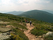
Presidential Traverse
The so-called Presidential TraversePresidential Traverse
A Presidential Traverse is a strenuous and sometimes dangerous trek over the Presidential Range of New Hampshire's White Mountains. Contained almost entirely in the White Mountain National Forest, the Presidential Range is a string of summits in excess of...
is a hike
Hiking
Hiking is an outdoor activity which consists of walking in natural environments, often in mountainous or other scenic terrain. People often hike on hiking trails. It is such a popular activity that there are numerous hiking organizations worldwide. The health benefits of different types of hiking...
which traverses each major summit along the 19 miles (30.6 km) Presidential ridge, encompassing at least 8,500 feet in elevation gain. It can be done in a single day in summer, but during winter it is generally a two- to four-day venture, and even so several rescues of lost, overdue or injured hikers have occurred during range traverses.