
Point Pinole Regional Shoreline
Encyclopedia

Regional park
Regional park is a term used for an area of land preserved on account of its natural beauty, historic interest, recreational use or other reason, and under the administration of a form of local government.-Definition:...
on the shores of the San Pablo Bay
San Pablo Bay
San Pablo Bay is a tidal estuary that forms the northern extension of San Francisco Bay in northern California in the United States. Most of the Bay is shallow; however, there is a deep water channel approximately in mid bay, which allows access to Sacramento, Stockton, Benicia, Martinez, and...
, California
California
California is a state located on the West Coast of the United States. It is by far the most populous U.S. state, and the third-largest by land area...
(the northern arm of the San Francisco Bay
San Francisco Bay
San Francisco Bay is a shallow, productive estuary through which water draining from approximately forty percent of California, flowing in the Sacramento and San Joaquin rivers from the Sierra Nevada mountains, enters the Pacific Ocean...
). It is approximately 9 square kilometres (2,223.9 acre) in area, and is operated by the East Bay Regional Park District
East Bay Regional Park District
The East Bay Regional Park District is a special district operating in Alameda County and Contra Costa County, California, within the East Bay area of the San Francisco Bay Area...
.
History
Point Pinole is located in the city of Richmond, CaliforniaRichmond, California
Richmond is a city in western Contra Costa County, California, United States. The city was incorporated on August 7, 1905. It is located in the East Bay, part of the San Francisco Bay Area. It is a residential inner suburb of San Francisco, as well as the site of heavy industry, which has been...
. It is on the site of a number of former explosives factories; the largest of these was operated by the Giant Powder Company, which was relocated to this relatively remote spot following accidental explosions at its former sites in San Francisco
San Francisco, California
San Francisco , officially the City and County of San Francisco, is the financial, cultural, and transportation center of the San Francisco Bay Area, a region of 7.15 million people which includes San Jose and Oakland...
and Berkeley
Berkeley, California
Berkeley is a city on the east shore of the San Francisco Bay in Northern California, United States. Its neighbors to the south are the cities of Oakland and Emeryville. To the north is the city of Albany and the unincorporated community of Kensington...
. Although the factory operated until 1960, little trace of it now remains, other than its former tramway grades, which provide a network of nearly 20 kilometres (12.4 mi) of gently sloping paths for hiking
Hiking
Hiking is an outdoor activity which consists of walking in natural environments, often in mountainous or other scenic terrain. People often hike on hiking trails. It is such a popular activity that there are numerous hiking organizations worldwide. The health benefits of different types of hiking...
, cycling
Cycling
Cycling, also called bicycling or biking, is the use of bicycles for transport, recreation, or for sport. Persons engaged in cycling are cyclists or bicyclists...
and horse-riding. The other relic of the park's industrial past are the large number of eucalyptus
Eucalyptus
Eucalyptus is a diverse genus of flowering trees in the myrtle family, Myrtaceae. Members of the genus dominate the tree flora of Australia...
glades which were planted around the factory site "for safety reasons" (as the park literature mysteriously states.)
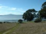
The park is a promontory, located where the East Bay shoreline turns from running south towards Berkeley and Oakland
Oakland, California
Oakland is a major West Coast port city on San Francisco Bay in the U.S. state of California. It is the eighth-largest city in the state with a 2010 population of 390,724...
to running eastwards, inland. It thus offers superb views across the bay in all directions, towards San Francisco to the southwest, Mount Tamalpais
Mount Tamalpais
Mount Tamalpais is a peak in Marin County, California, United States, often considered symbolic of Marin County. Much of Mount Tamalpais is protected within public lands such as Mount Tamalpais State Park and the Mount Tamalpais Watershed.-Geography:...
and the Marin Headlands
Marin Headlands
The Marin Headlands is a hilly area at the southernmost end of Marin County, California, just north of the Golden Gate Bridge. The Headlands are located just north of San Francisco, immediately across the Golden Gate Bridge. The entire area is part of the Golden Gate National Recreation Area...
to the northwest, and inland across San Pablo Bay to the north and east. Fresh and ocean waters mix at this point, so the marine life is rich; a leisure pier has been built at the end of promontory, replacing a former jetty used by the factories, and is a popular location for angling
Angling
Angling is a method of fishing by means of an "angle" . The hook is usually attached to a fishing line and the line is often attached to a fishing rod. Fishing rods are usually fitted with a fishing reel that functions as a mechanism for storing, retrieving and paying out the line. The hook itself...
.
The parks trails are flat and not at all challenging, there is a $5 parking fee.
Environment and wildlife
The park is a mixture of grassland and woodland, with beaches and low cliffs, and it has a particularly rich birdBird
Birds are feathered, winged, bipedal, endothermic , egg-laying, vertebrate animals. Around 10,000 living species and 188 families makes them the most speciose class of tetrapod vertebrates. They inhabit ecosystems across the globe, from the Arctic to the Antarctic. Extant birds range in size from...
life, including many duck
Duck
Duck is the common name for a large number of species in the Anatidae family of birds, which also includes swans and geese. The ducks are divided among several subfamilies in the Anatidae family; they do not represent a monophyletic group but a form taxon, since swans and geese are not considered...
s and shorebirds, and the endangered Black Rail
Black Rail
The Black Rail is a mouse-sized member of the Rallidae family of birds. It is found in scattered parts of North America and the Pacific region of South America, usually in coastal salt marshes but also in some freshwater marshes. It is extinct or threatened in many locations due to habitat loss...
. It is located on the Pacific Flyway
Pacific Flyway
The Pacific Flyway is a major north-south route of travel for migratory birds in America, extending from Alaska to Patagonia. Every year, migratory birds travel some or all of this distance both in spring and in fall, following food sources, heading to breeding grounds, or travelling to...
, so many migrant species are also seen.
The park is located on the Hayward Fault
Hayward Fault Zone
The Hayward Fault Zone is a geologic fault zone capable of generating significantly destructive earthquakes. This strike-slip fault is about long, situated mainly along the western base of the hills on the east side of San Francisco Bay...
, whose exact position is marked by monuments erected by the United States Geological Survey
United States Geological Survey
The United States Geological Survey is a scientific agency of the United States government. The scientists of the USGS study the landscape of the United States, its natural resources, and the natural hazards that threaten it. The organization has four major science disciplines, concerning biology,...
. The USGS has a seismometer posted along the Union Pacific Railroad
Union Pacific Railroad
The Union Pacific Railroad , headquartered in Omaha, Nebraska, is the largest railroad network in the United States. James R. Young is president, CEO and Chairman....
, which divides the park from the mainland; the park is reached via a bridge across the railroad.
The San Francisco Bay Trail
San Francisco Bay Trail
The San Francisco Bay Trail is a bicycle and pedestrian trail that will eventually allow continuous travel around the shoreline of San Francisco Bay. As of 2011, approximately 310 miles of trail have been completed...
runs through the park. The park can be reached by the AC Transit
AC Transit
AC Transit is an Oakland-based regional public transit agency serving the western half of Alameda County and parts of western Contra Costa County in the western, Bay-side area of the East Bay of the San Francisco Bay Area...
bus service, by car, or by bicycle. Pedestrian
Pedestrian
A pedestrian is a person traveling on foot, whether walking or running. In some communities, those traveling using roller skates or skateboards are also considered to be pedestrians. In modern times, the term mostly refers to someone walking on a road or footpath, but this was not the case...
and cyclist admission is free, but there is a parking fee.
External links
- Point Pinole at the East Bay Regional Park District web page
- A photograph of the plaque which sites the Giant Powder Company (Text-only version)
- A short history of California Historical Landmarks, including 1002
- Wikimapia aerial image of Point Pinole