
Plettenberg Bay
Encyclopedia
Bitou Local Municipality
Bitou Local Municipality is a municipality part of Eden District Municipality located in the Western Cape Province of South Africa. As of 2001, its population is 29,149. Its municipality code is WC047....
in the Western Cape Province of South Africa
South Africa
The Republic of South Africa is a country in southern Africa. Located at the southern tip of Africa, it is divided into nine provinces, with of coastline on the Atlantic and Indian oceans...
. As of the census of 2001, there were 29149 population. It was originally named Bahia Formosa (beautiful bay) by early Portuguese
Portugal
Portugal , officially the Portuguese Republic is a country situated in southwestern Europe on the Iberian Peninsula. Portugal is the westernmost country of Europe, and is bordered by the Atlantic Ocean to the West and South and by Spain to the North and East. The Atlantic archipelagos of the...
explorers and lies on South Africa's Garden Route
Garden Route
The Garden Route is a popular stretch of the south-eastern coast of South Africa. It stretches from Heidelberg in the Western Cape to the Storms River which is crossed along the N2 coastal highway over the Paul Sauer Bridge in the extreme western reach of the neighbouring Eastern Cape...
210 km from Port Elizabeth and about 600 km from Cape Town
Cape Town
Cape Town is the second-most populous city in South Africa, and the provincial capital and primate city of the Western Cape. As the seat of the National Parliament, it is also the legislative capital of the country. It forms part of the City of Cape Town metropolitan municipality...
.
Mesolithic
Caves in Nelson's Bay Cave and Matjies River Cave at nearby KeurboomstrandKeurboomstrand, Western Cape
Keurboomstrand is a resort town near Plettenberg Bay on the Western Cape of South Africa. It takes its name from the indigenous keurboom tree which grows in the region. The Keurbooms River runs nearby.-History:...
indicate they were inhabited for over 100 000 years by Mesolithic
Mesolithic
The Mesolithic is an archaeological concept used to refer to certain groups of archaeological cultures defined as falling between the Paleolithic and the Neolithic....
(Middle Stone Age) man and then later by ancestors of the Khoisan
Khoisan
Khoisan is a unifying name for two ethnic groups of Southern Africa, who share physical and putative linguistic characteristics distinct from the Bantu majority of the region. Culturally, the Khoisan are divided into the foraging San and the pastoral Khoi...
, who were possibly the same people who traded with the Portuguese
Portugal
Portugal , officially the Portuguese Republic is a country situated in southwestern Europe on the Iberian Peninsula. Portugal is the westernmost country of Europe, and is bordered by the Atlantic Ocean to the West and South and by Spain to the North and East. The Atlantic archipelagos of the...
survivors of the San Gonzales shipwreck. Their tools, ornaments and food debris can be viewed in these caves, which are still being excavated.
Modern
Long before Jan van RiebeeckJan van Riebeeck
Johan Anthoniszoon "Jan" van Riebeeck was a Dutch colonial administrator and founder of Cape Town.-Biography:...
landed at the Cape, Portuguese
Portugal
Portugal , officially the Portuguese Republic is a country situated in southwestern Europe on the Iberian Peninsula. Portugal is the westernmost country of Europe, and is bordered by the Atlantic Ocean to the West and South and by Spain to the North and East. The Atlantic archipelagos of the...
explorers charted the bay in the 15th and 16th centuries, the first being Bartholomew Dias in 1487. Ninety years later Manuel da Perestrello aptly called it Bahia Formosa or the Beautiful Bay. The first Europe
Europe
Europe is, by convention, one of the world's seven continents. Comprising the westernmost peninsula of Eurasia, Europe is generally 'divided' from Asia to its east by the watershed divides of the Ural and Caucasus Mountains, the Ural River, the Caspian and Black Seas, and the waterways connecting...
an inhabitants were 100 Portuguese sailors marooned here for 9 months when the San Gonzales sank in the bay in 1630. The survivors built two small boats which they used to link with a passing vessel. A stone that they left behind on Beacon Island, known as the Van Plettenberg Stone, is now in the Cape Town museum. In 1763, the first Europe
Europe
Europe is, by convention, one of the world's seven continents. Comprising the westernmost peninsula of Eurasia, Europe is generally 'divided' from Asia to its east by the watershed divides of the Ural and Caucasus Mountains, the Ural River, the Caspian and Black Seas, and the waterways connecting...
an settlers in the Bay were stock farmers, hunters and frontiersmen from the Western Cape
Western Cape
The Western Cape is a province in the south west of South Africa. The capital is Cape Town. Prior to 1994, the region that now forms the Western Cape was part of the much larger Cape Province...
.
A stinkwood
Stinkwood
Stinkwood is the common name for a number of trees or shrubs which have wood with an unpleasant odour, including:*Celtis africana – native to South Africa...
navigational beacon was first erected on Beacon Island in 1771. The original was a square block of stinkwood, inscribed with the latitude and longitude of Plettenberg Bay and erected to enable mariners to check their location. It was replaced by a stone one by Captain Sewell in 1881.
The bay housed a barracks for the Dutch East India Company
Dutch East India Company
The Dutch East India Company was a chartered company established in 1602, when the States-General of the Netherlands granted it a 21-year monopoly to carry out colonial activities in Asia...
in 1776. The Governor of the Cape, Baron Joachim van Plettenberg, renamed the town Plettenberg Bay in 1779. In 1869 it was bought by St Peters Church and used as a rectory for the next 70 years. Today it is presently privately owned.
In 1787/88 by Johann Jerling and the Dutch East India Company
Dutch East India Company
The Dutch East India Company was a chartered company established in 1602, when the States-General of the Netherlands granted it a 21-year monopoly to carry out colonial activities in Asia...
, erected a Timber Shed; the remains can still be seen and are preserved as a National Monument.
A whaling station was built on Beacon Island in 1910, but was closed down in 1916. Parts of the iron slipway are still visible today.
A hotel called The Beacon Isle Southern Sun Hotel now stands where the whaling station used to.
Ecology
Plettenberg Bay hosts one of the largest seagull breeding colonies along the South African coast at the mouth of the Keurboom's River, named after the indigenous keurboom treeVirgilia (genus)
Virgilia is a genus of Southern African trees in the family Fabaceae, having shiny to hairy pinnate leaves and attractive mauve to pink pea-shaped flowers followed by leathery pods...
.
The Robberg Peninsular is home to a large seal colony and one can see seals playing and hunting in the surf off Robberg Beach. Local vegetation varies from Cape Fynbos
Fynbos
Fynbos is the natural shrubland or heathland vegetation occurring in a small belt of the Western Cape of South Africa, mainly in winter rainfall coastal and mountainous areas with a Mediterranean climate...
to indigenous forest
Knysna-Amatole montane forests
The Knysna-Amatole montane forests ecoregion, of the Tropical and subtropical moist broadleaf forests Biome, is in South Africa. It covers an Afromontane area of in South Africa's Eastern Cape and Western Cape provinces.-Setting:...
further inland. Whales are a common sight in the bay during their breeding season, while dolphin
Dolphin
Dolphins are marine mammals that are closely related to whales and porpoises. There are almost forty species of dolphin in 17 genera. They vary in size from and , up to and . They are found worldwide, mostly in the shallower seas of the continental shelves, and are carnivores, mostly eating...
s are frequently seen in the surf. A delicate flower-shaped sea shell called a pansy shell is endemic to this part of the coast, and is used as the symbol representing the town. Looking for these shells on the beach is a popular activity amongst visitors and locals alike. Robberg Peninsula is maintained as a nature reserve
Nature reserve
A nature reserve is a protected area of importance for wildlife, flora, fauna or features of geological or other special interest, which is reserved and managed for conservation and to provide special opportunities for study or research...
, allowing visitors to see many of the area's local plants and animals.
In December 1977, the area was impacted by an oil spill from the Venpet-Venoil collision
Venpet-Venoil Collision
The Venpet-Venoil collision was a maritime accident involving sister supertankers; the Liberian-registered Venoil and Venpet, in dense fog off the coast of South Africa on 16 December 1977...
, which occurred 60 km offshore when two supertankers collided.
Shopping
A variety of shops, supermarkets, clothing, and entertainment stores cater to both locals and tourists. Plett's Main Street is home to a number of beach shops selling surf boards, swimming costumes, beach clothes, towels and other clothing. Due to the region's access to fresh fish and meat, there are a number of fish shops, butchers, and restaurants downtown.In addition to market stands and trade shops near Plett's taxi rank, commercial developments over the past 20 years have brought luxury apartments and upscale dining to Main Street, effectively making it a high street that stands apart from the rest of the town.
Climate and geography
Plettenberg Bay is typified by an extremely mild maritime temperateTemperate
In geography, temperate or tepid latitudes of the globe lie between the tropics and the polar circles. The changes in these regions between summer and winter are generally relatively moderate, rather than extreme hot or cold...
climate with very few rainfall or temperature extremes. It is located within the Knysna Afromontane Forest
Knysna-Amatole montane forests
The Knysna-Amatole montane forests ecoregion, of the Tropical and subtropical moist broadleaf forests Biome, is in South Africa. It covers an Afromontane area of in South Africa's Eastern Cape and Western Cape provinces.-Setting:...
biome, containing temperate gallery forest, supported by the mild temperatures and high, even distributed rainfall. Here follows the records for the closest climate station just to the east in the Tsitsikamma
Tsitsikamma Mountains
The Tsitsikamma mountains are a mountain range located in the Garden Route region of the southern South African coast in the Western Cape and Eastern Cape provinces. Stretching just over 80 km from the Keurbooms River in the west just north of Plettenberg Bay, to Kareedouw Pass in the east near the...
:
- Maximum/minimum temperatures: January: 23 °C/17 °C; July: 17 °C/10 °C; rainfall: 945 mm per annum.
The bay is defined on the southern end by Cape Seal at the terminus of the Robberg (Afrikaans
Afrikaans
Afrikaans is a West Germanic language, spoken natively in South Africa and Namibia. It is a daughter language of Dutch, originating in its 17th century dialects, collectively referred to as Cape Dutch .Afrikaans is a daughter language of Dutch; see , , , , , .Afrikaans was historically called Cape...
for Seal Mountain) Peninsula, separating the bay from the open Indian Ocean
Indian Ocean
The Indian Ocean is the third largest of the world's oceanic divisions, covering approximately 20% of the water on the Earth's surface. It is bounded on the north by the Indian Subcontinent and Arabian Peninsula ; on the west by eastern Africa; on the east by Indochina, the Sunda Islands, and...
. It is one of the southern cape coast's typical "J-shaped" bays, which is formed by wave action eroding the shales
Shalës
Shalës is a municipality in the Elbasan District, Elbasan County, central Albania. The municipality consists of the villages Shalës, Licaj, Kurtalli, Xibrake, Xherie and Kodras....
of the Bokkeveld Group between the weather-resistant headlands composed of the Table Mountain Group
Table Mountain sandstone
The Table Mountain Sandstone is a group of rock formations within the Cape Supergroup sequence of rocks. Although still widely used in common parlance, the term TMS is no longer formally recognized; the correct name is the "Table Mountain Group" . The sequence is dominated by quartzites of very...
, both of the Cape Supergroup geological sequence of rocks. To the north, the Tsitsikamma
Tsitsikamma Mountains
The Tsitsikamma mountains are a mountain range located in the Garden Route region of the southern South African coast in the Western Cape and Eastern Cape provinces. Stretching just over 80 km from the Keurbooms River in the west just north of Plettenberg Bay, to Kareedouw Pass in the east near the...
and Langkloof Mountains
Langkloof Mountains
The Langkloof Mountains are a short mountain range within the Cape Fold Belt in the Western Cape of South Africa. They form a link between the Outeniqua and Tsitsikamma Mountains to the north of Plettenberg Bay in the Garden Route region. They stretch from Prince Alfred's Pass in the west to just...
keeps the moisture on the southern slopes of the mountains and prevent the temperature extremes of the interior reaching the bay.
Tourism
Tourism is a thriving industry in this area, starting in November when teenage school leavers are the first to descend upon the small town, followed thereafter by various waves of arrivals from abroad as well as other parts of South Africa.The infrastructure of the town struggles to cope at the peak of the summer season, with traffic congestion and booked-out restaurants common from November to January.
The greater Plettenberg Bay area (known as Bitou) is also home to Birds of Eden, the largest free-flight bird aviary in the world, and the free-roaming primate
Primate
A primate is a mammal of the order Primates , which contains prosimians and simians. Primates arose from ancestors that lived in the trees of tropical forests; many primate characteristics represent adaptations to life in this challenging three-dimensional environment...
sanctuary called Monkeyland, among many other tourist attractions.
ShowMe Plettenberg Bay is a comprehensive website and local resource covering tourism, events, entertainment, accommodation, restaurants, property, charity and business.
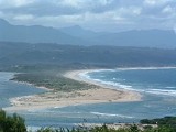
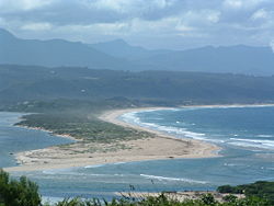
Beaches
The white, sandy beaches around the town are very popular with tourists, who have the following to choose from:- Robberg Beach
- Central Beach (at the Beacon Isle Hotel)
- Lookout Beach (flood-ravaged in November 2007)
- Keurboomstrand (rough tides happen fairly frequently)
See also
- Bitou
- KnysnaKnysnaKnysna is a town with 76,431 inhabitants in the Western Cape Province of South Africa and is part of the Garden Route. It lies 34 degrees south of the equator, and is 72 kilometres east from the town of George on the N2 highway, and 25 kilometres west of Plettenberg Bay on the same road.-History:A...
- Keurboomstrand, Western CapeKeurboomstrand, Western CapeKeurboomstrand is a resort town near Plettenberg Bay on the Western Cape of South Africa. It takes its name from the indigenous keurboom tree which grows in the region. The Keurbooms River runs nearby.-History:...
- Garden RouteGarden RouteThe Garden Route is a popular stretch of the south-eastern coast of South Africa. It stretches from Heidelberg in the Western Cape to the Storms River which is crossed along the N2 coastal highway over the Paul Sauer Bridge in the extreme western reach of the neighbouring Eastern Cape...
- Tsitsikamma National ParkTsitsikamma National ParkThe Tsitsikamma National Park is a coastal reserve on the Garden Route in South Africa. It is well known for indigenous forests, dramatic coastline, and the Otter Trail. On 6 March 2009 it was amalgamated with the Wilderness National Park and various other areas of land to form the Garden Route...