

Tsitsikamma National Park
Encyclopedia
Garden Route
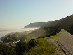
The Garden Route is a popular stretch of the south-eastern coast of South Africa. It stretches from Heidelberg in the Western Cape to the Storms River which is crossed along the N2 coastal highway over the Paul Sauer Bridge in the extreme western reach of the neighbouring Eastern Cape...
in South Africa
South Africa
The Republic of South Africa is a country in southern Africa. Located at the southern tip of Africa, it is divided into nine provinces, with of coastline on the Atlantic and Indian oceans...
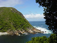
. It is well known for indigenous forests, dramatic coastline, and the Otter Trail
Otter Trail
The Otter Trail is a hiking trail along the Garden Route coast of South Africa and is named for the Cape Clawless Otter which occurs in this region. This trail is widely regarded as one of the finest in the world and stretches from Storms River Mouth in the east to Nature's Valley in the west, is...
. On 6 March 2009 it was amalgamated with the Wilderness National Park
Wilderness National Park
Wilderness National Park, located in Wilderness in the Western Cape, was a South African National Park which was incorporated into the Garden Route National Park when it was proclaimed on March 6, 2009.-External links:*...
and various other areas of land to form the Garden Route National Park
Garden Route National Park
The Garden Route National Park is a national park in the Garden Route region of South Africa. It was established on 6 March 2009 by amalgamating the existing Tsitsikamma and Wilderness National Parks, the Knysna National Lake Area, and various other areas of state-owned land.The park covers about ...
.
The park covers an 80 km long stretch of coastline. Nature's Valley
Nature's Valley
Nature's Valley is a holiday resort and small village on the Garden Route along the southern Cape coast of South Africa, tucked between the Soutrivier, the foothills of the Tsitsikamma Mountains, the Indian Ocean and the Groot River lagoon...
is at the western end of the park, and the main accommodation is at Storms River Mouth
Storms River
Storms River is a river in the Eastern Cape province of South Africa. The river mouth is located in the Tsitsikamma National Park.- See also :* Tsitsikamma National Park* Paul Sauer Bridge* List of rivers of South Africa...
. Near the park is the Bloukrans Bridge
Bloukrans Bridge
The Bloukrans Bridge is an arch bridge located near Nature's Valley, Western Cape, South Africa. The construction, which was completed in 1984, stands at height of 216m above the Bloukrans River, making it the highest single span arch bridge in the world...
, the world's highest bungee jump at 216m.
The word tsitsikamma is a Khoisan phrase meaning place of abundant water.
Storms River
There are various amenities, including a restaurant, shop, chalets, camp site and caravan park, information centre, the Agulhas lookout platform, trees marked with their national tree list numbers and underwater trails.Trails
The Otter TrailOtter Trail
The Otter Trail is a hiking trail along the Garden Route coast of South Africa and is named for the Cape Clawless Otter which occurs in this region. This trail is widely regarded as one of the finest in the world and stretches from Storms River Mouth in the east to Nature's Valley in the west, is...
starts at the Storms River camp and the South African National Parks
South African National Parks
South African National Parks is the body responsible for managing South Africa's national parks. SANParks was formed in 1926, and currently manages 20 parks consisting of , about 3% of the total area of South Africa....
has laid out several short trails for day visitors. Set in the Garden Route
Garden Route
The Garden Route is a popular stretch of the south-eastern coast of South Africa. It stretches from Heidelberg in the Western Cape to the Storms River which is crossed along the N2 coastal highway over the Paul Sauer Bridge in the extreme western reach of the neighbouring Eastern Cape...
, the trails lead through coastal and forest scenes, as well as various waterfalls, streams and rivers.
l. The Suspension Bridge and Lookout Trail is an easy stroll that leads along the western side of the river mouth, past the Strandloper Cave to the suspension bridge across the mouth.
On the other side of the bridge there is a short but very steep climb to a lookout point from which there are fine views of the mouth and the camp.
2. The Waterfall Trail is an undemanding hike which follows the first 2,65 km of the Otter Trail; hikers may not walk beyond the waterfall unless hiking the Otter Trail.
3. The Blue Duiker Trail starts just west of the information centre and leads through scrub forest tip to the Agulhas lookout from where whales and dolphins can often be spotted in winter. After crossing a short section of fynbos, the trail takes hikers into the dry forest with some fine Sickle-leaved Yellowwood
Afrocarpus falcatus
Afrocarpus falcatus, commonly known as the Sickle-leaved Yellowwood and False Yellowwood Afrocarpus falcatus, commonly known as the Sickle-leaved Yellowwood and False Yellowwood Afrocarpus falcatus, commonly known as the Sickle-leaved Yellowwood and False Yellowwood (formerly also Outeniqua...
s evident. A short-cut, the Lourie Trail, branches to the left here.
The Blue Duiker Trail continues through the forest, crossing a stream below a delightful waterfall. Several more streams and a cavernous tree bole mark the route. After crossing the road to the camp, the path drops to the coast just west of the start of the Waterfall/Otter trails and returns past the camp site and chalets. Birdlife unique to the forest is found west of the road, which makes this trail a favourite with birdwatchers.