
Pennsylvania Route 263
Encyclopedia
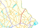
Pennsylvania Route 263 is a north–south state highway
located in southeast Pennsylvania
. The southern terminus of the route is at PA 611
in Willow Grove
, Montgomery County
. The northern terminus is at PA 32
in Centre Bridge
, Bucks County
on the banks of the Delaware River
near the Centre Bridge-Stockton Bridge
. It follows the routing of Old York Road
, a historic road that connected Philadelphia to New York City
, and carries the name York Road from the southern terminus to Lahaska
and Upper York Road north of there. From Willow Grove to Buckingham
, PA 263 runs mostly through suburban areas as a four-lane road, passing through Hatboro
, Warminster, and Jamison
. The route forms a concurrency
with U.S. Route 202
(US 202) and narrows to a two-lane road, splitting with that route in Lahaska. From here, the route continues through rural areas to Centre Bridge.
PA 263 follows a part of the alignment of Old York Road, which was laid out in 1711. In 1911, the portion of the current route south of Lahaska became part of Legislative Route 155. When Pennsylvania designated its state highways, PA 263 was assigned to its current alignment between Willow Grove and Centre Bridge.
 PA 263 starts as York Road at its southern terminus at PA 611
(Easton Road) in the unincorporated village of Willow Grove
in Upper Moreland Township
, Montgomery County
. At the southern terminus, the route is split into a one-way pair
, with the route carrying two lanes in each direction. The northbound lanes split north from northbound PA 611 while the southbound lanes head west and meet PA 611 at the Center Avenue intersection. At the end of the one-way pair, PA 263 continues north as a four-lane undivided road, passing through commercial areas with a few homes. The road passes under Norfolk Southern's Morrisville Line and becomes a divided highway
as it passes under the Pennsylvania Turnpike
(I-276). Upon intersecting Mill Road/Warminster Road, PA 263 becomes undivided again as it heads into more residential surroundings.
The route briefly forms the border between Hatboro
to the east and Upper Moreland Township to the west before fully entering Hatboro past the Newington Drive intersection. Here, PA 263 heads north prior to turning northeast and intersecting Horsham Road. At this point, the route crosses the Pennypack Creek
and heads into the commercial downtown of Hatboro as a three-lane road with a center left-turn lane. The route turns north at Byberry Road and comes to a junction with the western terminus of PA 332
(Montgomery Avenue). After passing Summit Avenue, PA 263 leaves the downtown area and becomes a four-lane undivided road again, passing residential areas with a few businesses. Through Hatboro, PA 263 is also called the Roy W. Cornell Memorial Highway.
line and enters Warminster Township
. In this area, the route is a five-lane road with a center left-turn lane and passes several suburban businesses as it comes to the PA 132
(Street Road) intersection, where it becomes a four-lane divided highway. The road passes more commercial surroundings until the divided highway ends at Roberts Road. PA 263 gains a center left-turn lane again as it continues north through more residential areas with a few businesses. Just before Bristol Road, Old York Road splits off from the route and PA 263 curves more to the northeast, retaining the name York Road.
At Bristol Road, PA 263 enters Warwick Township
and becomes a four-lane divided highway as it turns north near residential subdivisions. The surroundings become more wooded as the route crosses the Little Neshaminy Creek. The road continues into areas of farm fields and residential and commercial development and regains a center left-turn lane as it reaches an intersection with Almshouse Road in the community of Jamison
. At this intersection, the route is briefly a divided highway. After Almshouse Road, PA 263 continues north through business areas before heading past residential developments. The route turns back into a divided highway as it crosses over the Neshaminy Creek
and passes through areas woodland and homes. The road leaves Warwick Township for Buckingham Township
at the Sugar Bottom Road intersection.
 In Buckingham Township, PA 263 becomes a four-lane undivided road passes a mix of farmland and homes as it comes to the community of Furlong. Here, the road intersects Edison Furlong Road/Forest Grove Road and forms the border between Doylestown Township
to the west and Buckingham Township to the east, passing a few businesses. At the intersection with the eastern terminus of PA 313
(Swamp Road), the route fully enters Buckingham Township again and turns northeast past wooded areas of homes. Farther to the northeast, the route runs between a farm to the southeast and more wooded development to the northwest as it reaches the residential and commercial community of Buckingham and crosses PA 413
(Durham Road).
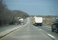
PA 263 narrows to two lanes past this intersection and forms a concurrency
with US 202 a short distance later. The two routes run along a two-lane undivided road that passes areas of farms and woods with some homes and businesses, passing through the community of Holicong. Past this area, the development decreases as US 202/PA 263 continues northeast through more rural surroundings. Upon reaching the unincorporated village of Lahaska
, the two routes split, with PA 263 bearing off to the left and becoming Upper York Road, a two-lane undivided road. The route passes through Peddler's Village
before coming to an intersection with Street Road. At Street Road, PA 263 exits Buckingham Township and enters Solebury Township
.
The road continues north into farm fields and woods with a few homes, curving more to the northeast. At the Aquetong Road intersection, PA 263 turns north and back to the northeast as it passes to the west of a residential development. The route passes more rural development as it reaches the community of Solebury, where the road intersects Sugan Road. In this area, the road passes a few homes. Past this area, the road continues through wooded areas of homes, with the forests become denser as the road heads more to the northeast. In the village of Centre Bridge
, PA 263 ends at PA 32 (River Road) just before Upper York Road crosses the Centre Bridge-Stockton Bridge
over the Delaware River and into Stockton
, New Jersey
, where the road continues to an intersection with Route 29 near the southern terminus of County Route 523
.
, a road established in the 18th century to connect Philadelphia to New York City
. The portion of the road encompassing all of PA 263 was planned in 1711 to run from Philadelphia to Centre Bridge. The Old York Road would later exist as a turnpike
. In 1911, the part of PA 263 between the southern terminus and Lahaska was designated as part of Legislative Route 155, a route that ran from Willow Grove to New Hope.
By 1930, PA 263 was designated to run from US 611 in Willow Grove to PA 32 in Centre Bridge. The Upper York Road portion of PA 263 was paved by 1940. By 1970, the route was widened into a four-lane highway between County Line Road and PA 413 in Buckingham. In 2006, the portion of PA 263 through Hatboro was named the Roy W. Cornell Memorial Highway in honor of Roy Cornell
, a member of the Pennsylvania General Assembly
who had represented Hatboro for over 30 years.
State highway
State highway, state road or state route can refer to one of three related concepts, two of them related to a state or provincial government in a country that is divided into states or provinces :#A...
located in southeast Pennsylvania
Pennsylvania
The Commonwealth of Pennsylvania is a U.S. state that is located in the Northeastern and Mid-Atlantic regions of the United States. The state borders Delaware and Maryland to the south, West Virginia to the southwest, Ohio to the west, New York and Ontario, Canada, to the north, and New Jersey to...
. The southern terminus of the route is at PA 611
Pennsylvania Route 611
Pennsylvania Route 611 is a major state highway in Pennsylvania, United States, running from Interstate 95 south of downtown Philadelphia north to Interstate 380 in Coolbaugh Township, Pennsylvania in The Poconos....
in Willow Grove
Willow Grove, Pennsylvania
Willow Grove is a census-designated place in Montgomery County, Pennsylvania. A community in Philadelphia's northern suburbs, the population was 15,726 at the 2010 census. It is located in Abington Township and Upper Moreland Township...
, Montgomery County
Montgomery County, Pennsylvania
Montgomery County is a county located in the U.S. state of Pennsylvania, in the United States. As of 2010, the population was 799,874, making it the third most populous county in Pennsylvania . The county seat is Norristown.The county was created on September 10, 1784, out of land originally part...
. The northern terminus is at PA 32
Pennsylvania Route 32
Pennsylvania Route 32 is a scenic two-lane highway that runs along the side of the Delaware River in Bucks County, Pennsylvania. It begins at U.S. 1 in Falls Township and ends at Pennsylvania Route 611 near the village of Kintnersville...
in Centre Bridge
Centre Bridge, Pennsylvania
Centre Bridge is an unincorporated community on the Delaware River in Solebury Township, Bucks County, Pennsylvania, United States. Located at the crossroads of River Road and 263), it lies north of New Hope...
, Bucks County
Bucks County, Pennsylvania
- Industry and commerce :The boroughs of Bristol and Morrisville were prominent industrial centers along the Northeast Corridor during World War II. Suburban development accelerated in Lower Bucks in the 1950s with the opening of Levittown, Pennsylvania, the second such "Levittown" designed by...
on the banks of the Delaware River
Delaware River
The Delaware River is a major river on the Atlantic coast of the United States.A Dutch expedition led by Henry Hudson in 1609 first mapped the river. The river was christened the South River in the New Netherland colony that followed, in contrast to the North River, as the Hudson River was then...
near the Centre Bridge-Stockton Bridge
Centre Bridge-Stockton Bridge
The Centre Bridge–Stockton Bridge is a free bridge over the Delaware River owned and operated by the Delaware River Joint Toll Bridge Commission...
. It follows the routing of Old York Road
Old York Road
Old York Road or King's Highway is a roadway that was built in the 18th century to connect Philadelphia, Pennsylvania with New York City, New York. Through New Jersey it was built along the Raritan "Naraticong Trail"...
, a historic road that connected Philadelphia to New York City
New York City
New York is the most populous city in the United States and the center of the New York Metropolitan Area, one of the most populous metropolitan areas in the world. New York exerts a significant impact upon global commerce, finance, media, art, fashion, research, technology, education, and...
, and carries the name York Road from the southern terminus to Lahaska
Lahaska, Pennsylvania
Lahaska is an unincorporated community in central Bucks County, Pennsylvania, United States. It lies just east of Buckingham and west of New Hope on Route 202. Lahaska is home to one of the most popular shopping areas in the region, Peddler's Village, as well as Buckingham Friends School, a...
and Upper York Road north of there. From Willow Grove to Buckingham
Buckingham Township, Bucks County, Pennsylvania
Buckingham Township is a township in Bucks County, Pennsylvania, United States. The population was 20,075 at the 2010 census. Buckingham takes its name from Buckingham in Buckinghamshire known as Bucks County in England...
, PA 263 runs mostly through suburban areas as a four-lane road, passing through Hatboro
Hatboro, Pennsylvania
Hatboro is a borough in Montgomery County, Pennsylvania, United States. The population was 7,360 at the 2010 census.-Geography:Hatboro is located at ....
, Warminster, and Jamison
Jamison, Pennsylvania
Jamison, Pennsylvania is a village located on Route 263 in Warwick Township, Bucks County. Its zip code is 18929 and the township municipal building is located at 1733 Township Greene just south of the village....
. The route forms a concurrency
Concurrency (road)
A concurrency, overlap, or coincidence in a road network is an instance of one physical road bearing two or more different highway, motorway, or other route numbers...
with U.S. Route 202
U.S. Route 202 in Pennsylvania
U.S. Route 202 runs through the southeastern part of the U.S. state of Pennsylvania, passing through the northern and western suburbs of Philadelphia. It follows in a general southwest to northeast direction through the state, passing through West Chester, King of Prussia, Norristown,...
(US 202) and narrows to a two-lane road, splitting with that route in Lahaska. From here, the route continues through rural areas to Centre Bridge.
PA 263 follows a part of the alignment of Old York Road, which was laid out in 1711. In 1911, the portion of the current route south of Lahaska became part of Legislative Route 155. When Pennsylvania designated its state highways, PA 263 was assigned to its current alignment between Willow Grove and Centre Bridge.
Montgomery County
Pennsylvania Route 611
Pennsylvania Route 611 is a major state highway in Pennsylvania, United States, running from Interstate 95 south of downtown Philadelphia north to Interstate 380 in Coolbaugh Township, Pennsylvania in The Poconos....
(Easton Road) in the unincorporated village of Willow Grove
Willow Grove, Pennsylvania
Willow Grove is a census-designated place in Montgomery County, Pennsylvania. A community in Philadelphia's northern suburbs, the population was 15,726 at the 2010 census. It is located in Abington Township and Upper Moreland Township...
in Upper Moreland Township
Upper Moreland Township, Pennsylvania
Upper Moreland Township is a township in Montgomery County, Pennsylvania, United States. The population was 24,015 at the 2010 census. Upper Moreland Township is primarily a residential community with distinctive neighborhoods that are complemented by several thriving business, industrial, and...
, Montgomery County
Montgomery County, Pennsylvania
Montgomery County is a county located in the U.S. state of Pennsylvania, in the United States. As of 2010, the population was 799,874, making it the third most populous county in Pennsylvania . The county seat is Norristown.The county was created on September 10, 1784, out of land originally part...
. At the southern terminus, the route is split into a one-way pair
One-way pair
A one-way pair, one-way couple, or just couplet is a pair of parallel, usually one-way streets that carry opposite directions of a signed route or major traffic flow, or sometimes opposite directions of a bus or streetcar route....
, with the route carrying two lanes in each direction. The northbound lanes split north from northbound PA 611 while the southbound lanes head west and meet PA 611 at the Center Avenue intersection. At the end of the one-way pair, PA 263 continues north as a four-lane undivided road, passing through commercial areas with a few homes. The road passes under Norfolk Southern's Morrisville Line and becomes a divided highway
Divided Highway
Divided Highway is a compilation album by American rock band The Doobie Brothers, released in 2003. . All tracks are taken from the albums Cycles and Brotherhood .-Track listing:...
as it passes under the Pennsylvania Turnpike
Pennsylvania Turnpike
The Pennsylvania Turnpike is a toll highway system operated by the Pennsylvania Turnpike Commission in the Commonwealth of Pennsylvania, United States. The three sections of the turnpike system total . The main section extends from Ohio to New Jersey and is long...
(I-276). Upon intersecting Mill Road/Warminster Road, PA 263 becomes undivided again as it heads into more residential surroundings.
The route briefly forms the border between Hatboro
Hatboro, Pennsylvania
Hatboro is a borough in Montgomery County, Pennsylvania, United States. The population was 7,360 at the 2010 census.-Geography:Hatboro is located at ....
to the east and Upper Moreland Township to the west before fully entering Hatboro past the Newington Drive intersection. Here, PA 263 heads north prior to turning northeast and intersecting Horsham Road. At this point, the route crosses the Pennypack Creek
Pennypack Creek
Pennypack Creek is a creek in southeastern Pennsylvania in the United States. It runs southeast through eastern Montgomery County, lower Bucks County, and the northeast section of Philadelphia, before emptying into the Delaware River.-Name:...
and heads into the commercial downtown of Hatboro as a three-lane road with a center left-turn lane. The route turns north at Byberry Road and comes to a junction with the western terminus of PA 332
Pennsylvania Route 332
Pennsylvania Route 332 is a state highway in the U.S. state of Pennsylvania. The route runs from Pennsylvania Route 263 in Hatboro, Montgomery County east to Pennsylvania Route 32 in Yardley, Bucks County.-Route description:...
(Montgomery Avenue). After passing Summit Avenue, PA 263 leaves the downtown area and becomes a four-lane undivided road again, passing residential areas with a few businesses. Through Hatboro, PA 263 is also called the Roy W. Cornell Memorial Highway.
Bucks County
At the intersection with County Line Road, PA 263 crosses the Bucks CountyBucks County, Pennsylvania
- Industry and commerce :The boroughs of Bristol and Morrisville were prominent industrial centers along the Northeast Corridor during World War II. Suburban development accelerated in Lower Bucks in the 1950s with the opening of Levittown, Pennsylvania, the second such "Levittown" designed by...
line and enters Warminster Township
Warminster Township, Pennsylvania
Warminster Township is a township in Bucks County, Pennsylvania, United States. The population was 32,682 at the 2010 census.The town was named for the town of Warminster in Wiltshire, England.-Geography:...
. In this area, the route is a five-lane road with a center left-turn lane and passes several suburban businesses as it comes to the PA 132
Pennsylvania Route 132
Pennsylvania Route 132 is a state highway in southeast Pennsylvania. It runs northwest to southeast through Bucks County in suburban Philadelphia from PA 611 in Warrington Township to Interstate 95 in Bensalem Township. It is a commercial route lined with shopping centers throughout much of its...
(Street Road) intersection, where it becomes a four-lane divided highway. The road passes more commercial surroundings until the divided highway ends at Roberts Road. PA 263 gains a center left-turn lane again as it continues north through more residential areas with a few businesses. Just before Bristol Road, Old York Road splits off from the route and PA 263 curves more to the northeast, retaining the name York Road.
At Bristol Road, PA 263 enters Warwick Township
Warwick Township, Bucks County, Pennsylvania
Warwick Township is a township in Bucks County, Pennsylvania, United States. The population was 14,437 at the 2010 census.-Geography:According to the United States Census Bureau, the township has a total area of 11.1 square miles , all of it land. It is drained by the Delaware River via the...
and becomes a four-lane divided highway as it turns north near residential subdivisions. The surroundings become more wooded as the route crosses the Little Neshaminy Creek. The road continues into areas of farm fields and residential and commercial development and regains a center left-turn lane as it reaches an intersection with Almshouse Road in the community of Jamison
Jamison, Pennsylvania
Jamison, Pennsylvania is a village located on Route 263 in Warwick Township, Bucks County. Its zip code is 18929 and the township municipal building is located at 1733 Township Greene just south of the village....
. At this intersection, the route is briefly a divided highway. After Almshouse Road, PA 263 continues north through business areas before heading past residential developments. The route turns back into a divided highway as it crosses over the Neshaminy Creek
Neshaminy Creek
Neshaminy Creek is a stream that runs southeast through Bucks County, Pennsylvania. Neshaminy Creek proper rises south of the borough of Chalfont, where North Branch Neshaminy Creek and West Branch Neshaminy Creek meet. Neshaminy Creek flows lastly between Bristol Township and Bensalem Township...
and passes through areas woodland and homes. The road leaves Warwick Township for Buckingham Township
Buckingham Township, Bucks County, Pennsylvania
Buckingham Township is a township in Bucks County, Pennsylvania, United States. The population was 20,075 at the 2010 census. Buckingham takes its name from Buckingham in Buckinghamshire known as Bucks County in England...
at the Sugar Bottom Road intersection.
Doylestown Township, Pennsylvania
Doylestown Township is a township in Bucks County, Pennsylvania, United States. The population was 17,565 at the 2010 census. Adjacent to the county seat, many county offices and the county correctional facility are located in this township.-Geography:...
to the west and Buckingham Township to the east, passing a few businesses. At the intersection with the eastern terminus of PA 313
Pennsylvania Route 313
Pennsylvania Route 313 is a mostly 2-lane, long state highway entirely within Bucks County, Pennsylvania. It is an east–west road, although it runs almost purely northwest/southeast through most of its course...
(Swamp Road), the route fully enters Buckingham Township again and turns northeast past wooded areas of homes. Farther to the northeast, the route runs between a farm to the southeast and more wooded development to the northwest as it reaches the residential and commercial community of Buckingham and crosses PA 413
Pennsylvania Route 413
Pennsylvania Route 413 is a long, north–south state highway running from the PA/NJ state line on the Burlington-Bristol Bridge to PA 611 in Bedminster Township in Bucks County...
(Durham Road).
PA 263 narrows to two lanes past this intersection and forms a concurrency
Concurrency (road)
A concurrency, overlap, or coincidence in a road network is an instance of one physical road bearing two or more different highway, motorway, or other route numbers...
with US 202 a short distance later. The two routes run along a two-lane undivided road that passes areas of farms and woods with some homes and businesses, passing through the community of Holicong. Past this area, the development decreases as US 202/PA 263 continues northeast through more rural surroundings. Upon reaching the unincorporated village of Lahaska
Lahaska, Pennsylvania
Lahaska is an unincorporated community in central Bucks County, Pennsylvania, United States. It lies just east of Buckingham and west of New Hope on Route 202. Lahaska is home to one of the most popular shopping areas in the region, Peddler's Village, as well as Buckingham Friends School, a...
, the two routes split, with PA 263 bearing off to the left and becoming Upper York Road, a two-lane undivided road. The route passes through Peddler's Village
Peddler's Village
Peddler's Village is a 42 acre 18th century style attraction in Bucks County, Pennsylvania featuring more than 70 shops and restaurants, a 70 room Inn and a Family Entertainment Center. It has festivals, craft competitions and an antique carousel. The destination is also used for weddings, holiday...
before coming to an intersection with Street Road. At Street Road, PA 263 exits Buckingham Township and enters Solebury Township
Solebury Township, Pennsylvania
Solebury Township is a township in Bucks County, Pennsylvania, United States. The population was 8,692 at the 2010 census.The Solebury School is located in the township, off U.S...
.
The road continues north into farm fields and woods with a few homes, curving more to the northeast. At the Aquetong Road intersection, PA 263 turns north and back to the northeast as it passes to the west of a residential development. The route passes more rural development as it reaches the community of Solebury, where the road intersects Sugan Road. In this area, the road passes a few homes. Past this area, the road continues through wooded areas of homes, with the forests become denser as the road heads more to the northeast. In the village of Centre Bridge
Centre Bridge, Pennsylvania
Centre Bridge is an unincorporated community on the Delaware River in Solebury Township, Bucks County, Pennsylvania, United States. Located at the crossroads of River Road and 263), it lies north of New Hope...
, PA 263 ends at PA 32 (River Road) just before Upper York Road crosses the Centre Bridge-Stockton Bridge
Centre Bridge-Stockton Bridge
The Centre Bridge–Stockton Bridge is a free bridge over the Delaware River owned and operated by the Delaware River Joint Toll Bridge Commission...
over the Delaware River and into Stockton
Stockton, New Jersey
Stockton is a Borough in Hunterdon County, New Jersey, United States. The borough sits on the Delaware River at the western end of Amwell Valley...
, New Jersey
New Jersey
New Jersey is a state in the Northeastern and Middle Atlantic regions of the United States. , its population was 8,791,894. It is bordered on the north and east by the state of New York, on the southeast and south by the Atlantic Ocean, on the west by Pennsylvania and on the southwest by Delaware...
, where the road continues to an intersection with Route 29 near the southern terminus of County Route 523
County Route 523 (New Jersey)
County Route 523 is a county highway in the U.S. state of New Jersey. The highway extends from Main Street in Stockton to Hillside Avenue in Bedminster Township.-Hunterdon County:...
.
History
What is now PA 263 was originally built as part of the Old York RoadOld York Road
Old York Road or King's Highway is a roadway that was built in the 18th century to connect Philadelphia, Pennsylvania with New York City, New York. Through New Jersey it was built along the Raritan "Naraticong Trail"...
, a road established in the 18th century to connect Philadelphia to New York City
New York City
New York is the most populous city in the United States and the center of the New York Metropolitan Area, one of the most populous metropolitan areas in the world. New York exerts a significant impact upon global commerce, finance, media, art, fashion, research, technology, education, and...
. The portion of the road encompassing all of PA 263 was planned in 1711 to run from Philadelphia to Centre Bridge. The Old York Road would later exist as a turnpike
Toll road
A toll road is a privately or publicly built road for which a driver pays a toll for use. Structures for which tolls are charged include toll bridges and toll tunnels. Non-toll roads are financed using other sources of revenue, most typically fuel tax or general tax funds...
. In 1911, the part of PA 263 between the southern terminus and Lahaska was designated as part of Legislative Route 155, a route that ran from Willow Grove to New Hope.
By 1930, PA 263 was designated to run from US 611 in Willow Grove to PA 32 in Centre Bridge. The Upper York Road portion of PA 263 was paved by 1940. By 1970, the route was widened into a four-lane highway between County Line Road and PA 413 in Buckingham. In 2006, the portion of PA 263 through Hatboro was named the Roy W. Cornell Memorial Highway in honor of Roy Cornell
Roy Cornell
Roy W. Cornell was a Republican member of the Pennsylvania House of Representatives.He was a 1961 graduate of Hatboro-Horsham High School and attended Santa Ana Junior College. He graduated from Temple University and from the North Philadelphia Board of Realtors School. He was first elected to...
, a member of the Pennsylvania General Assembly
Pennsylvania General Assembly
The Pennsylvania General Assembly is the state legislature of the U.S. state of Pennsylvania. The legislature convenes in the State Capitol building in Harrisburg. In colonial times , the legislature was known as the Pennsylvania Provincial Assembly. Since the Constitution of 1776, written by...
who had represented Hatboro for over 30 years.