

Stockton, New Jersey
Encyclopedia
Stockton is a Borough
in Hunterdon County
, New Jersey
, United States
. The borough sits on the Delaware River
at the western end of Amwell Valley
. As of the United States 2010 Census, the borough population was 538.
Stockton was incorporated as a borough by an Act of the New Jersey Legislature
on April 14, 1898, from portions of Delaware Township
.
According to the United States Census Bureau
, the borough has a total area of 0.6 square miles (1.6 km²), of which, 0.6 square miles (1.6 km²) of it is land and 0.1 square mile (0.258998811 km²) of it (10.00%) is water.
Stockton borders Delaware Township
in New Jersey. The Centre Bridge-Stockton Bridge
, a free bridge over the Delaware River
, owned and operated by the Delaware River Joint Toll Bridge Commission
, connects Pennsylvania Route 32
and Pennsylvania Route 263
in Solebury Township
, Pennsylvania
to Route 29 in Stockton. The original bridge, constructed at the site formerly known as Reading's Ferry, was opened to traffic in the spring of 1814. The covered bridge was destroyed in a flood on January 8, 1841, striking the Lambertville Bridge on its way down the Delaware, as part of a flood that severely damaged every bridge between Easton, Pennsylvania
and Trenton
.
of 2000, there were 560 people, 246 households, and 148 families residing in the borough. The population density
was 1,026.5 people per square mile (393.1/km2). There were 258 housing units at an average density of 472.9 per square mile (181.1/km2). The racial makeup of the borough was 98.57% White, 0.89% Asian, and 0.54% from two or more races. Hispanic or Latino of any race were 0.54% of the population.
There were 246 households out of which 28.5% had children under the age of 18 living with them, 50.4% were married couples
living together, 6.5% had a female householder with no husband present, and 39.8% were non-families. 30.5% of all households were made up of individuals and 11.0% had someone living alone who was 65 years of age or older. The average household size was 2.28 and the average family size was 2.94.
In the borough the population was spread out with 21.3% under the age of 18, 4.3% from 18 to 24, 34.5% from 25 to 44, 25.2% from 45 to 64, and 14.8% who were 65 years of age or older. The median age was 41 years. For every 100 females there were 87.9 males. For every 100 females age 18 and over, there were 85.3 males.
The median income for a household in the borough was $51,406, and the median income for a family was $65,000. Males had a median income of $42,083 versus $36,250 for females. The per capita income
for the borough was $25,712. About 1.3% of families and 2.0% of the population were below the poverty line, including 1.7% of those under age 18 and 1.0% of those age 65 or over.
form of New Jersey municipal government. The government consists of a Mayor and a Borough Council comprising six council members, with all positions elected at large. A Mayor is elected directly by the voters to a four-year term of office. The Borough Council consists of six members elected to serve three-year terms on a staggered basis, with two seats coming up for election each year.
The Mayor
of Stockton Borough is Stephen Giocondo. Members of the Borough Council are Kate Steffanelli, Neal Esposito, Nic Messina, Michael Hagerty, Timothy Nemeth and Andrew Doughtery .
based on the results of the 2010 Census. The new district is in effect for the June 2011 primary and the November 2011 general election, with the state senator and assembly members elected taking office in the new district as of January 2012.
Stockton is in the
serves public school students in preschool through eighth grade. The Stockton Borough School had an enrollment of 45 students as of the 2005-06 school year.
Public school students in grade 7 - 12 attend the South Hunterdon Regional High School
, part of the South Hunterdon Regional High School District, which serves over 300 students in southern Hunterdon County. Students from Lambertville
, Stockton and West Amwell Township
attend the high school, which is located in Lambertville.
north of Lambertville
. The community was first known as Reading Ferry and later as Howell's Ferry. The name was changed to Centre Bridge Station to match the name of the post office and hamlet on the Pennsylvania
side of the river. The name became Stockton with the creation of a local post office in 1851. The town was named in honor of U.S. Senator Robert Field Stockton, who was instrumental in the creation of the Delaware and Raritan Canal
. The Borough was incorporated in 1898, having been separated from Delaware Township
.
 The tiny town remains today as it was in the eighteenth century. for all its small size and charm, the town is presided over by an old inn. The Stockton Inn (formally known as Colligan's Stockton Inn), established in 1710, is the inn that was immortalized by Richard Rodgers
in the song "There's a small hotel with a wishing well", sung in the Broadway play On Your Toes
. The inn was first built as a private residence and is believed to have been converted in 1832. Now, The Stockton Inn is a restaurant with fireside dining in the Winter, and outdoor dining in the Spring and Summer. The Stockton Inn had been closed for quite some time during the past year or so because the inn was being sold, but was recently bought by Fred Strackhouse and is now up and running again.
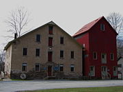
The Delaware River Mill Society was formed to preserve and promote the buildings and site known as the Prallsville Mills. John Prall, Jr., became the owner of the site in 1794 and with his settlement the area became known as Prallsville.
The Delaware River Mill Society is a private non- profit organization responsible for the restoration, maintenance, and operation of the historic John Prall Jr. House and the Prallsville Mills Complex, which was listed on the National Register of Historic Places
in 1973. The entire property became part of the D & R Canal State Park in 1973.
In 1976 when the State of New Jersey was unable to fund the restoration of its newly acquired Prallsville Mills, local citizens formed Delaware River Mill Society, to “restore, preserve, operate, maintain and interpret” the historic site. The Mill Society's mission is to save a segment of our past and make it a part of today's community. The Mill has become a place of cultural and environmental events attracting wide spread participation. Concerts, art exhibitions, antique shows, holiday parties, school fund-raiser auctions, meetings, as well as private parties, are a source of income for restoration and maintenance of the site. The site currently includes artist Ty Hodanish's studio and gallery, known as The Art Colony, which is housed in the Linseed Mill. The Mill is also situated in the center of the Delaware River Scenic Byway.
Borough (New Jersey)
A borough in the context of New Jersey local government refers to one of five types and one of eleven forms of municipal government....
in Hunterdon County
Hunterdon County, New Jersey
Hunterdon County is a county located in the western section of the U.S. state of New Jersey. As of the 2010 United States Census, the population was 128,349. It is part of the New York Metropolitan Area. Its county seat is Flemington....
, New Jersey
New Jersey
New Jersey is a state in the Northeastern and Middle Atlantic regions of the United States. , its population was 8,791,894. It is bordered on the north and east by the state of New York, on the southeast and south by the Atlantic Ocean, on the west by Pennsylvania and on the southwest by Delaware...
, United States
United States
The United States of America is a federal constitutional republic comprising fifty states and a federal district...
. The borough sits on the Delaware River
Delaware River
The Delaware River is a major river on the Atlantic coast of the United States.A Dutch expedition led by Henry Hudson in 1609 first mapped the river. The river was christened the South River in the New Netherland colony that followed, in contrast to the North River, as the Hudson River was then...
at the western end of Amwell Valley
Amwell Valley
The Amwell Valley is a small valley in Hunterdon County, New Jersey, between the Hunterdon Plateau and the Sourlands. It comprises Stockton, parts of Delaware Township, West Amwell, East Amwell, Flemington and Raritan Township. The region borders the Delaware River to the west and the South...
. As of the United States 2010 Census, the borough population was 538.
Stockton was incorporated as a borough by an Act of the New Jersey Legislature
New Jersey Legislature
The New Jersey Legislature is the legislative branch of the government of the U.S. state of New Jersey. In its current form, as defined by the New Jersey Constitution of 1947, the Legislature consists of two houses: the General Assembly and the Senate...
on April 14, 1898, from portions of Delaware Township
Delaware Township, Hunterdon County, New Jersey
-Demographics:As of the census of 2000, there were 4,478 people, 1,643 households, and 1,302 families residing in the township. The population density was 121.9 people per square mile . There were 1,701 housing units at an average density of 46.3 per square mile...
.
Geography
Stockton is located at 40.406701°N 74.977546°W (40.406701, -74.977546).According to the United States Census Bureau
United States Census Bureau
The United States Census Bureau is the government agency that is responsible for the United States Census. It also gathers other national demographic and economic data...
, the borough has a total area of 0.6 square miles (1.6 km²), of which, 0.6 square miles (1.6 km²) of it is land and 0.1 square mile (0.258998811 km²) of it (10.00%) is water.
Stockton borders Delaware Township
Delaware Township, Hunterdon County, New Jersey
-Demographics:As of the census of 2000, there were 4,478 people, 1,643 households, and 1,302 families residing in the township. The population density was 121.9 people per square mile . There were 1,701 housing units at an average density of 46.3 per square mile...
in New Jersey. The Centre Bridge-Stockton Bridge
Centre Bridge-Stockton Bridge
The Centre Bridge–Stockton Bridge is a free bridge over the Delaware River owned and operated by the Delaware River Joint Toll Bridge Commission...
, a free bridge over the Delaware River
Delaware River
The Delaware River is a major river on the Atlantic coast of the United States.A Dutch expedition led by Henry Hudson in 1609 first mapped the river. The river was christened the South River in the New Netherland colony that followed, in contrast to the North River, as the Hudson River was then...
, owned and operated by the Delaware River Joint Toll Bridge Commission
Delaware River Joint Toll Bridge Commission
The Delaware River Joint Toll Bridge Commission is a bistate, public agency charged with providing safe, dependable and efficient river crossings between Pennsylvania and New Jersey. The DRJTBC was established under legislation enacted in the two states in 1934. The federal Compact for the...
, connects Pennsylvania Route 32
Pennsylvania Route 32
Pennsylvania Route 32 is a scenic two-lane highway that runs along the side of the Delaware River in Bucks County, Pennsylvania. It begins at U.S. 1 in Falls Township and ends at Pennsylvania Route 611 near the village of Kintnersville...
and Pennsylvania Route 263
Pennsylvania Route 263
Pennsylvania Route 263 is a north–south state highway located in southeast Pennsylvania. The southern terminus of the route is at PA 611 in Willow Grove, Montgomery County. The northern terminus is at PA 32 in Centre Bridge, Bucks County on the banks of the Delaware River near the Centre...
in Solebury Township
Solebury Township, Pennsylvania
Solebury Township is a township in Bucks County, Pennsylvania, United States. The population was 8,692 at the 2010 census.The Solebury School is located in the township, off U.S...
, Pennsylvania
Pennsylvania
The Commonwealth of Pennsylvania is a U.S. state that is located in the Northeastern and Mid-Atlantic regions of the United States. The state borders Delaware and Maryland to the south, West Virginia to the southwest, Ohio to the west, New York and Ontario, Canada, to the north, and New Jersey to...
to Route 29 in Stockton. The original bridge, constructed at the site formerly known as Reading's Ferry, was opened to traffic in the spring of 1814. The covered bridge was destroyed in a flood on January 8, 1841, striking the Lambertville Bridge on its way down the Delaware, as part of a flood that severely damaged every bridge between Easton, Pennsylvania
Easton, Pennsylvania
Easton is a city in Northampton County, Pennsylvania, United States. The population was 26,800 as of the 2010 census. It is the county seat of Northampton County....
and Trenton
Trenton, New Jersey
Trenton is the capital of the U.S. state of New Jersey and the county seat of Mercer County. As of the 2010 United States Census, Trenton had a population of 84,913...
.
Demographics
As of the censusCensus
A census is the procedure of systematically acquiring and recording information about the members of a given population. It is a regularly occurring and official count of a particular population. The term is used mostly in connection with national population and housing censuses; other common...
of 2000, there were 560 people, 246 households, and 148 families residing in the borough. The population density
Population density
Population density is a measurement of population per unit area or unit volume. It is frequently applied to living organisms, and particularly to humans...
was 1,026.5 people per square mile (393.1/km2). There were 258 housing units at an average density of 472.9 per square mile (181.1/km2). The racial makeup of the borough was 98.57% White, 0.89% Asian, and 0.54% from two or more races. Hispanic or Latino of any race were 0.54% of the population.
There were 246 households out of which 28.5% had children under the age of 18 living with them, 50.4% were married couples
Marriage
Marriage is a social union or legal contract between people that creates kinship. It is an institution in which interpersonal relationships, usually intimate and sexual, are acknowledged in a variety of ways, depending on the culture or subculture in which it is found...
living together, 6.5% had a female householder with no husband present, and 39.8% were non-families. 30.5% of all households were made up of individuals and 11.0% had someone living alone who was 65 years of age or older. The average household size was 2.28 and the average family size was 2.94.
In the borough the population was spread out with 21.3% under the age of 18, 4.3% from 18 to 24, 34.5% from 25 to 44, 25.2% from 45 to 64, and 14.8% who were 65 years of age or older. The median age was 41 years. For every 100 females there were 87.9 males. For every 100 females age 18 and over, there were 85.3 males.
The median income for a household in the borough was $51,406, and the median income for a family was $65,000. Males had a median income of $42,083 versus $36,250 for females. The per capita income
Per capita income
Per capita income or income per person is a measure of mean income within an economic aggregate, such as a country or city. It is calculated by taking a measure of all sources of income in the aggregate and dividing it by the total population...
for the borough was $25,712. About 1.3% of families and 2.0% of the population were below the poverty line, including 1.7% of those under age 18 and 1.0% of those age 65 or over.
Government
Stockton is governed under the BoroughBorough (New Jersey)
A borough in the context of New Jersey local government refers to one of five types and one of eleven forms of municipal government....
form of New Jersey municipal government. The government consists of a Mayor and a Borough Council comprising six council members, with all positions elected at large. A Mayor is elected directly by the voters to a four-year term of office. The Borough Council consists of six members elected to serve three-year terms on a staggered basis, with two seats coming up for election each year.
The Mayor
Mayor
In many countries, a Mayor is the highest ranking officer in the municipal government of a town or a large urban city....
of Stockton Borough is Stephen Giocondo. Members of the Borough Council are Kate Steffanelli, Neal Esposito, Nic Messina, Michael Hagerty, Timothy Nemeth and Andrew Doughtery .
Federal, state and county representation
Stockton Borough is in the 12th Congressional district and is part of New Jersey's 23rd state legislative district. The township was relocated to the 16th state legislative district by the New Jersey Apportionment CommissionNew Jersey Apportionment Commission
The New Jersey Apportionment Commission is a constitutionally-created ten-member commission responsible for apportioning the forty districts of the New Jersey Legislature. The commission is convened after each decennial U.S. Census, and the districts are to be in use for the legislative elections...
based on the results of the 2010 Census. The new district is in effect for the June 2011 primary and the November 2011 general election, with the state senator and assembly members elected taking office in the new district as of January 2012.
Stockton is in the
Education
The Stockton Borough School DistrictStockton Borough School District
The Stockton Borough School District is a community public school district that serves students in preschool through sixth grade from Stockton, in Hunterdon County, New Jersey, United States...
serves public school students in preschool through eighth grade. The Stockton Borough School had an enrollment of 45 students as of the 2005-06 school year.
Public school students in grade 7 - 12 attend the South Hunterdon Regional High School
South Hunterdon Regional High School
South Hunterdon Regional High School is a regional public high school and secondary school district serving three communities in southern Hunterdon County. It is the smallest public high school in the state of New Jersey. Students in grade 7 - 12 attend the school, which serves students from...
, part of the South Hunterdon Regional High School District, which serves over 300 students in southern Hunterdon County. Students from Lambertville
Lambertville, New Jersey
Lambertville is a city in Hunterdon County, New Jersey, United States. As of the 2010 United States Census, the city population was 3,906.Lambertville was originally incorporated as a town by an Act of the New Jersey Legislature on March 1, 1849, from portions of West Amwell Township...
, Stockton and West Amwell Township
West Amwell Township, New Jersey
The Delaware River separates West Amwell from the Commonwealth of Pennsylvania.-Demographics:As of the census of 2000, there were 2,383 people, 949 households, and 696 families residing in the township. The population density was 109.7 people per square mile . There were 984 housing units at an...
attend the high school, which is located in Lambertville.
History
Stockton is located along the Delaware RiverDelaware River
The Delaware River is a major river on the Atlantic coast of the United States.A Dutch expedition led by Henry Hudson in 1609 first mapped the river. The river was christened the South River in the New Netherland colony that followed, in contrast to the North River, as the Hudson River was then...
north of Lambertville
Lambertville, New Jersey
Lambertville is a city in Hunterdon County, New Jersey, United States. As of the 2010 United States Census, the city population was 3,906.Lambertville was originally incorporated as a town by an Act of the New Jersey Legislature on March 1, 1849, from portions of West Amwell Township...
. The community was first known as Reading Ferry and later as Howell's Ferry. The name was changed to Centre Bridge Station to match the name of the post office and hamlet on the Pennsylvania
Pennsylvania
The Commonwealth of Pennsylvania is a U.S. state that is located in the Northeastern and Mid-Atlantic regions of the United States. The state borders Delaware and Maryland to the south, West Virginia to the southwest, Ohio to the west, New York and Ontario, Canada, to the north, and New Jersey to...
side of the river. The name became Stockton with the creation of a local post office in 1851. The town was named in honor of U.S. Senator Robert Field Stockton, who was instrumental in the creation of the Delaware and Raritan Canal
Delaware and Raritan Canal
The Delaware and Raritan Canal is a canal in central New Jersey, United States, built in the 1830s that served to connect the Delaware River to the Raritan River. It was intended as an efficient and reliable means of transportation of freight between Philadelphia, Pennsylvania and New York City,...
. The Borough was incorporated in 1898, having been separated from Delaware Township
Delaware Township, Hunterdon County, New Jersey
-Demographics:As of the census of 2000, there were 4,478 people, 1,643 households, and 1,302 families residing in the township. The population density was 121.9 people per square mile . There were 1,701 housing units at an average density of 46.3 per square mile...
.
Historic locations and sightseeing
Richard Rodgers
Richard Charles Rodgers was an American composer of music for more than 900 songs and for 43 Broadway musicals. He also composed music for films and television. He is best known for his songwriting partnerships with the lyricists Lorenz Hart and Oscar Hammerstein II...
in the song "There's a small hotel with a wishing well", sung in the Broadway play On Your Toes
On Your Toes
On Your Toes is a musical with a book by Richard Rodgers, George Abbott, and Lorenz Hart, music by Rodgers, and lyrics by Hart. It was adapted into a film in 1939....
. The inn was first built as a private residence and is believed to have been converted in 1832. Now, The Stockton Inn is a restaurant with fireside dining in the Winter, and outdoor dining in the Spring and Summer. The Stockton Inn had been closed for quite some time during the past year or so because the inn was being sold, but was recently bought by Fred Strackhouse and is now up and running again.
The Delaware River Mill Society was formed to preserve and promote the buildings and site known as the Prallsville Mills. John Prall, Jr., became the owner of the site in 1794 and with his settlement the area became known as Prallsville.
The Delaware River Mill Society is a private non- profit organization responsible for the restoration, maintenance, and operation of the historic John Prall Jr. House and the Prallsville Mills Complex, which was listed on the National Register of Historic Places
National Register of Historic Places
The National Register of Historic Places is the United States government's official list of districts, sites, buildings, structures, and objects deemed worthy of preservation...
in 1973. The entire property became part of the D & R Canal State Park in 1973.
In 1976 when the State of New Jersey was unable to fund the restoration of its newly acquired Prallsville Mills, local citizens formed Delaware River Mill Society, to “restore, preserve, operate, maintain and interpret” the historic site. The Mill Society's mission is to save a segment of our past and make it a part of today's community. The Mill has become a place of cultural and environmental events attracting wide spread participation. Concerts, art exhibitions, antique shows, holiday parties, school fund-raiser auctions, meetings, as well as private parties, are a source of income for restoration and maintenance of the site. The site currently includes artist Ty Hodanish's studio and gallery, known as The Art Colony, which is housed in the Linseed Mill. The Mill is also situated in the center of the Delaware River Scenic Byway.
Notable residents
Notable current and former residents of Stockton include:- JP MillerJP MillerJames Pinckney Miller , known to friends and associates by the nickname Pappy, wrote under the name JP Miller. He was a leading playwright during the Golden Age of Television, receiving three Emmy nominations...
(1919–2001), a leading writer of teleplays during the Golden Age of Television., James A. Michener Art MuseumJames A. Michener Art MuseumThe James A. Michener Art Museum is a private, non-profit museum in Doylestown, Bucks County, Pennsylvania founded in 1988 and named for the Pulitzer Prize–winning writer James A. Michener, a Doylestown resident...
.
External links
- Hunterdon County web page for Stockton Borough
- Stockton Borough Elementary School
- Data for the Stockton Borough Elementary School, National Center for Education StatisticsNational Center for Education StatisticsThe National Center for Education Statistics is the part of the United States Department of Education's Institute of Education Sciences that collects, analyzes, and publishes statistics on education and public school district finance information in the United States...
- Stockton History
- Centre Bridge-Stockton article at the Delaware River Joint Toll Bridge Commission website
- An article about Stockton Borough's history at the Hunterdon County website
- Delaware River Mill Society's webpage for the Prallsville Mills complex
- Hunterdon Land Trust Alliance