

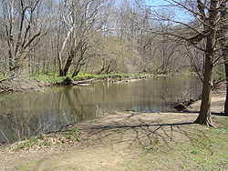
Pennypack Creek
Encyclopedia
Pennsylvania
The Commonwealth of Pennsylvania is a U.S. state that is located in the Northeastern and Mid-Atlantic regions of the United States. The state borders Delaware and Maryland to the south, West Virginia to the southwest, Ohio to the west, New York and Ontario, Canada, to the north, and New Jersey to...
in the United States
United States
The United States of America is a federal constitutional republic comprising fifty states and a federal district...
. It runs southeast through eastern Montgomery County
Montgomery County, Pennsylvania
Montgomery County is a county located in the U.S. state of Pennsylvania, in the United States. As of 2010, the population was 799,874, making it the third most populous county in Pennsylvania . The county seat is Norristown.The county was created on September 10, 1784, out of land originally part...
, lower Bucks County
Bucks County, Pennsylvania
- Industry and commerce :The boroughs of Bristol and Morrisville were prominent industrial centers along the Northeast Corridor during World War II. Suburban development accelerated in Lower Bucks in the 1950s with the opening of Levittown, Pennsylvania, the second such "Levittown" designed by...
, and the northeast section of Philadelphia, before emptying into the Delaware River
Delaware River
The Delaware River is a major river on the Atlantic coast of the United States.A Dutch expedition led by Henry Hudson in 1609 first mapped the river. The river was christened the South River in the New Netherland colony that followed, in contrast to the North River, as the Hudson River was then...
.
Name
The creek draws its name from the LenapeLenape language
The Delaware languages, also known as the Lenape languages, are Munsee and Unami, two closely related languages of the Eastern Algonquian subgroup of the Algonquian language family...
word pënëpèkw meaning "downward-flowing water" or "deep, dead water; water without much current." Early cartographers gave various spellings for the name, including Pennishpaska, La Riviere de Pennicpacka, and Pennishpacha Kyl. In early Swedish patents it was called Pemipacka. Thomas Holme
Thomas Holme
Thomas Holme was the first Surveyor General of Pennsylvania to actually serve, in which capacity he laid out the original plan for the city of Philadelphia.-Life:...
called it Dublin Creek, while in later maps it is called Pennypack and Pennepack.
Course
The Pennypack was first surveyed by Thomas HolmeThomas Holme
Thomas Holme was the first Surveyor General of Pennsylvania to actually serve, in which capacity he laid out the original plan for the city of Philadelphia.-Life:...
in 1687. The creek begins in two branches, one in Horsham
Horsham Township, Pennsylvania
Horsham Township is a home rule municipality in Montgomery County, Pennsylvania, United States. Although it retains the word "Township" in its official name, it has been governed by a home rule charter since 1975 and is therefore not subject to the Pennsylvania Township Code...
, the other in Warminster
Warminster Township, Pennsylvania
Warminster Township is a township in Bucks County, Pennsylvania, United States. The population was 32,682 at the 2010 census.The town was named for the town of Warminster in Wiltshire, England.-Geography:...
, joining in Bryn Athyn
Bryn Athyn, Pennsylvania
Bryn Athyn is a home rule municipality, in Montgomery County, Pennsylvania, United States. It was formerly a borough, and its official name remains "Borough of Bryn Athyn". The population was 1,375 at the 2010 census...
. The creek then flows through Lower Moreland
Lower Moreland Township, Pennsylvania
Lower Moreland Township is a township in Montgomery County, Pennsylvania, United States. The population was 12,982 at the 2010 census.-History:...
, Abington
Abington Township, Montgomery County, Pennsylvania
Abington Township is a township in Montgomery County, Pennsylvania, United States. The population was 55,310 in as of the 2010 census.Abington Township is one of Montgomery County's oldest communities dating back to before 1700 and being incorporated in 1704. It is home to some of the county's...
and Northeast Philadelphia
Northeast Philadelphia
Northeast Philadelphia, nicknamed Northeast Philly, the Northeast and the Great Northeast, is a section of the city of Philadelphia, Pennsylvania. According to the 2000 Census, the Northeast has a sizable percentage of the city's 1.547 million people — a population of between 300,000 and 450,000,...
.
Early use as an industrial waterway
Pennypack Creek was once the site of several mills. When William PennWilliam Penn
William Penn was an English real estate entrepreneur, philosopher, and founder of the Province of Pennsylvania, the English North American colony and the future Commonwealth of Pennsylvania. He was an early champion of democracy and religious freedom, notable for his good relations and successful...
founded the province of Pennsylvania
Province of Pennsylvania
The Province of Pennsylvania, also known as Pennsylvania Colony, was founded in British America by William Penn on March 4, 1681 as dictated in a royal charter granted by King Charles II...
in 1682, the Pennypack valley was occupied by Swedish colonists
Swedish colonization of the Americas
The Swedish colonization of the Americas included a 17th-century colony on the Delaware River in what is now Delaware, New Jersey, Pennsylvania, and Maryland, as well as two possessions in the Caribbean during the 18th and 19th century....
, who continued to live as English settlement began. Penn ordered the first bridge
Frankford Avenue Bridge
The Frankford Avenue Bridge, also known as the Pennypack Creek Bridge, the Pennypack Bridge, the Holmesburg Bridge, and the King's Highway Bridge, erected in 1697 or 1698 in the Holmesburg section of Northeast Philadelphia, Pennsylvania, is the oldest surviving roadway bridge in the United States...
built across the creek along the King's Highway (now Frankford Avenue) in 1697; the bridge still stands. Despite the lack of navigability beyond the fall line
Fall line
A fall line is a geomorphologic unconformity between an upland region of relatively hard crystalline basement rock and a coastal plain of softer sedimentary rock. A fall line is typically prominent when crossed by a river, for there will often be rapids or waterfalls...
(near the Frankford Avenue bridge), several early settlers built mills along the Pennypack, including Penn's "Pemmapecka Mill," built in 1701. The mills contributed to the growth of Holmesburg, the neighborhood near the mouth of the creek, and provided local farmers a place to sell their grain that was nearer than the city of Philadelphia.
Conversion to parkland
With the development of steam power in the Industrial RevolutionIndustrial Revolution
The Industrial Revolution was a period from the 18th to the 19th century where major changes in agriculture, manufacturing, mining, transportation, and technology had a profound effect on the social, economic and cultural conditions of the times...
, water power's influence on industry declined. As a result, many of the mills on the Pennypack closed, and by 1905 the land around it was acquired by the city for parkland. The creek now runs through Pennypack Park
Pennypack Park
Pennypack Park is a municipal park, part of Philadelphia's Fairmount Park system, in Northeast Philadelphia in the U.S. state of Pennsylvania. Established in 1905 by ordinance of the City of Philadelphia, it includes about of woodlands, meadows and wetlands. The Pennypack Creek runs through the...
in Philadelphia and Lorimer Park
Lorimer Park
Lorimer Park is a public park in Abington Township, Pennsylvania. The park, a bequest from the late George Horace Lorimer , is connected to Pennypack Park in Philadelphia County, and the Pennypack Creek runs through both parks...
in Montgomery County.
Historic bridges
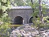
Several historic bridges cross Pennypack Creek and its tributaries.- The Frankford Avenue BridgeFrankford Avenue BridgeThe Frankford Avenue Bridge, also known as the Pennypack Creek Bridge, the Pennypack Bridge, the Holmesburg Bridge, and the King's Highway Bridge, erected in 1697 or 1698 in the Holmesburg section of Northeast Philadelphia, Pennsylvania, is the oldest surviving roadway bridge in the United States...
, a triple-span stone-arch bridge built in 1697, carries Frankford Avenue. It is the oldest bridge in the United States still in use. - The Fetters Mill Road Bridge, a Pratt through-truss bridge built in 1883, is still in use.
- The Krewstown Road Bridge, a stone arch bridge built in 1907, is still in use.
- The Holme Avenue Bridge, a closed-spandrel concrete arch bridge built in 1918, is still in use.
- The Roosevelt Boulevard Bridge, a closed-spandrel concrete arch bridge built in 1920, is still in use.
- The Holme Avenue BridgeHolme Avenue BridgeThe Holme Avenue Bridge is a closed-spandrel concrete arch bridge that carries Holme Avenue across Wooden Bridge Run in Philadelphia, Pennsylvania....
, a closed-spandrel concrete arch bridge across Wooden Bridge Run built in 1921, is still in use. - The Ryan Avenue Bridge, a closed-spandrel concrete arch bridge over Sandy Run built in 1929, is still in use.
- The Rhawn Street Bridges, two closed-spandrel concrete arches bridge built in 1930, are still in use.
External links
- U.S. Geological Survey: PA stream gaging stations
- A picture of Pennypack Creek from Windows Live LocalWindows Live LocalBing Maps is a web mapping service provided as a part of Microsoft's Bing suite of search engines and powered by the Bing Maps for Enterprise framework....
. This scene shows the creek as it flows beneath the bridgeFrankford Avenue BridgeThe Frankford Avenue Bridge, also known as the Pennypack Creek Bridge, the Pennypack Bridge, the Holmesburg Bridge, and the King's Highway Bridge, erected in 1697 or 1698 in the Holmesburg section of Northeast Philadelphia, Pennsylvania, is the oldest surviving roadway bridge in the United States...
on Frankford AvenueU.S. Route 13 in PennsylvaniaU.S. Route 13 passes through the Philadelphia metropolitan area in the U.S. state of Pennsylvania. The route enters the state from Delaware in Marcus Hook, Delaware County. It continues in a northeasterly direction through Delaware County, passes through Philadelphia, and continues into Bucks...
in HolmesburgHolmesburg, Philadelphia, PennsylvaniaHolmesburg is a neighborhood in the Northeast section of Philadelphia, Pennsylvania. Holmesburg was named for the descendants of John Holme who immigrated to Philadelphia in the 1680s and had no known relation to Surveyor General Thomas Holme. John Holme's descendants acquired land in Lower...
, believed to be the oldest stone arch bridge in use in the United States. - Pennypack in art: William Thompson Russell SmithWilliam Thompson Russell SmithRussell Smith was a Scottish painter who produced iconic images of Pennsylvania’s landscape inspired by the aesthetic of the Hudson River School.-Biography:...
(1812–1896) painted Jarrett Hallowell's Meadow on the Pennypack in 1880 link to Smith's Meadow - Pennypack in art: Xanthus Russell SmithXanthus Russell SmithXanthus Russell Smith was an American marine painter best known for his illustrations of the American Civil War.-Biography:...
(1839–1929) painted Turnpike Bridge on the Pennypack in 1881 link to Smith's Bridge - Pennypack Creek Watershed Study
- Friends of Pennypack Park
- Photographs - mostly of Pennypack Creek - from the Lincoln Cartledge Collection of the Historical Society of Frankford
- The Pennepack in Lower Dublin Township (now part of Philadelphia: see Act of Consolidation, 1854Act of Consolidation, 1854The Act of Consolidation, more formally known as the act of February 2, 1854 , was enacted by General Assembly of the Commonwealth of Pennsylvania and approved February 2, 1854 by Governor William Bigler...
) - Holme's map of 1687
- Headquartered at 2955 Edgehill Road in Huntingdon Valley, the Pennypack Ecological Restoration Trust manages the 725 acres (2.9 km²) Pennypack Preserve which is open to the public and includes 10 miles (16.1 km) of pedestrian, equestrian, and bicycle trails.