

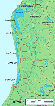
Peel-Harvey Estuary
Encyclopedia
Estuary
An estuary is a partly enclosed coastal body of water with one or more rivers or streams flowing into it, and with a free connection to the open sea....
which lies roughly parallel to the coast of Western Australia
Western Australia
Western Australia is a state of Australia, occupying the entire western third of the Australian continent. It is bounded by the Indian Ocean to the north and west, the Great Australian Bight and Indian Ocean to the south, the Northern Territory to the north-east and South Australia to the south-east...
and south of the town of Mandurah
Mandurah, Western Australia
Mandurah is the second-largest city in Western Australia and is located approximately south of the state capital, Perth.The city attracts a large number of tourists, including many international visitors...
. The strip of land between the Indian Ocean
Indian Ocean
The Indian Ocean is the third largest of the world's oceanic divisions, covering approximately 20% of the water on the Earth's surface. It is bounded on the north by the Indian Subcontinent and Arabian Peninsula ; on the west by eastern Africa; on the east by Indochina, the Sunda Islands, and...
and the estuary carries the Old Coast Road
Old Coast Road
Old Coast Road is a Western Australian highway linking Mandurah, WA's second-largest city located 75 km south of Perth, with Bunbury, WA's third-largest city. It is signed as Route 1 for most of its length and is long.-Overview:...
and to the east is the Forrest Highway which is the main thoroughfare between Perth
Perth, Western Australia
Perth is the capital and largest city of the Australian state of Western Australia and the fourth most populous city in Australia. The Perth metropolitan area has an estimated population of almost 1,700,000....
and the coastal towns of the south west corner of the state including Bunbury
Bunbury, Western Australia
The port city of Bunbury is the third largest city in Western Australia after the State Capital Perth and Mandurah. It is situated south of Perth's central business district...
and Busselton
Busselton, Western Australia
-Growth and development:According to the Australian Bureau of Statistics the Shire had a permanent resident population of 25,950 in 2004 with the town of Busselton accounting for 67% or 17,400 of the total. The Shire's permanent population is expected to continue to increase significantly to...
.
Description
The estuary covers an area of approximately 136 km² in total with an average water depth of about 2 m.The Harvey River
Harvey River
The Harvey River is a river in Western Australia and is the southernmost of the three major waterways which drain into the Peel-Harvey Estuary, with its delta in the southern extreme of the Harvey Estuary. It is about 90 km in length, rising near Mount Keats...
discharges into the extreme southern end of the elongated Harvey Estuary, which has an area of about 56 km². This in turn feeds into the south-western corner of the more northerly Peel Inlet which is roughly circular and occupies an area of about 75 km². The Serpentine River and Murray River
Murray River (Western Australia)
The Murray River is a river in the southwest of Western Australia which played a significant part in the expansion of Aboriginal settlement in the area south of Perth after the arrival of British settlers at the Swan River Colony in 1829....
s discharge into the eastern edges of Peel Inlet also.
A 5 km long channel which passes through the town of Mandurah, then runs into the ocean.
After several decades of severe algal bloom
Algal bloom
An algal bloom is a rapid increase or accumulation in the population of algae in an aquatic system. Algal blooms may occur in freshwater as well as marine environments. Typically, only one or a small number of phytoplankton species are involved, and some blooms may be recognized by discoloration...
s in the estuary caused by discharge of nutrients from agricultural land and piggeries along the rivers, a man-made channel
Channel (geography)
In physical geography, a channel is the physical confine of a river, slough or ocean strait consisting of a bed and banks.A channel is also the natural or human-made deeper course through a reef, sand bar, bay, or any shallow body of water...
was constructed and opened in 1994 as the Dawesville Channel
Dawesville Channel
Dawesville Channel is a man-made channel between the Peel-Harvey Estuary and the Indian Ocean at Dawesville about 80 km south of Perth in Western Australia...
. The channel had the effect of allowing saline sea-water to regularly flush the estuary using tidal flows. Whilst the ecology of the estuary has changed markedly due to the flushing process, water quality generally has improved.
The catchment area to the east is largely flat coastal plain with about 75% cleared of native vegetation and used for dryland, dairy and beef grazing. Clearing was done in the early days of settlement to allow agricultural expansion. Drainage systems into the three main rivers have been constructed in much of the catchment to remove excess water quickly.
Lake Preston, Lake Clifton and the Leschenault Estuary
Leschenault Estuary
Leschenault Estuary is an estuarine lagoon that lies to the north of Bunbury, Western Australia.It had in the past met the Indian Ocean at the Leschenault Inlet - but that has been altered by harbour works for Bunbury, and the creation of The Cut north of the historical inlet location.The estuary...
are farther south.
Flora and fauna
The estuary is home to abundant marine wildlife including crustaceans such as the Blue swimmer crab (Portunus pelagicus) and the Western king prawnKing Prawn
King Prawn were a prominent band of the UK ska punk scene during the 1990s and early 2000s.King Prawn blended elements of punk, hardcore, metal, ska, dub, reggae, and hip hop into their music, which they dubbed wildstyle....
(Penaeus latisulcatus) and fish species such as black bream
Black bream
Black bream may refer to:* One of two porgies in the genus Acanthopagrus.**Southern black bream, Acanthopagrus butcheri**Yellowfin bream, Acanthopagrus australis* Galjoen, Dichistius capensis* Black drummer, Girella elevata....
, mulloway, tailor
Bluefish
The bluefish , called tailor in Australia, is a species of popular marine gamefish found in all climates. It is the sole species of the Pomatomidae family....
and cobbler
South Australian cobbler
The South Australian cobbler, Gymnapistes marmoratus, often just called "cobbler" in Australia, is a brown coloured fish that lives in estuaries in southern Australia, both on the eastern and western coasts...
. It is occasionally visited by dolphin
Dolphin
Dolphins are marine mammals that are closely related to whales and porpoises. There are almost forty species of dolphin in 17 genera. They vary in size from and , up to and . They are found worldwide, mostly in the shallower seas of the continental shelves, and are carnivores, mostly eating...
s.
The estuary has been identified by BirdLife International
BirdLife International
BirdLife International is a global Partnership of conservation organisations that strives to conserve birds, their habitats and global biodiversity, working with people towards sustainability in the use of natural resources...
as an Important Bird Area
Important Bird Area
An Important Bird Area is an area recognized as being globally important habitat for the conservation of bird populations. Currently there are about 10,000 IBAs worldwide. The program was developed and sites are identified by BirdLife International...
(IBA) because it supports a significant population of Fairy Tern
Fairy Tern
The Fairy Tern is a small tern which occurs in the southwestern Pacific.There are three subspecies:* Australian Fairy Tern, Sterna nereis nereis - breeds in Australia...
s, is a drought refuge
Drought refuge
A drought refuge is a site that provides permanent fresh water or moist conditions for plants and animals, acting as a refuge habitat when surrounding areas are affected by drought and allowing ecosystems and core species populations to survive until the drought breaks...
for Blue-billed Duck
Blue-billed Duck
The Blue-billed Duck is a small Australian stiff-tailed duck, with both the male and female growing to a length of 40 cm . The male has a slate-blue bill which changes to bright-blue during the breeding season, hence the duck’s common name . The male has deep chestnut plumage during breeding...
s, and sometimes holds over 1% of the world populations of Red-necked Stint
Red-necked Stint
The Red-necked Stint is a small migratory wader.- Description :These birds are among the smallest of waders, very similar to the Little Stint, Calidris minuta, with which they were once considered conspecific...
s, Sharp-tailed Sandpiper
Sharp-tailed Sandpiper
The Sharp-tailed Sandpiper, Calidris acuminata is a small wader.- Taxonomy :More recently, a review of new data has indicated that this bird should perhaps better be placed into the genus Philomachus- as P...
s, Banded Stilt
Banded Stilt
The Banded Stilt is a nomadic stilt from Australia. It belongs to the monotypical genus Cladorhynchus. It gets its name from the red-brown breast band found on breeding adults, but this is mottled or entirely absent in non-breeding adults and juveniles. Its remaining plumage is pied and the eyes...
s, Red-necked Avocet
Red-necked Avocet
The Red-necked Avocet is a water bird found throughout Australia, except for the northern parts of the Northern Territory....
s and Red-capped Plover
Red-capped Plover
The Red-capped Plover , also known as the Red-capped Dotterel, is a small plover. It breeds in Australia. The species is closely related to the Kentish Plover, Javan Plover and White-fronted Plover.-Description:Red-capped Plovers have white underparts and forehead...
s.
Recreational use
The estuary is heavily used for recreational boating and fishing with numerous boat ramps and picnic sposts along the extensive foreshore with shaded sandy beaches. Houseboats can be hired at Mandurah to explore the estuary and the Murray River.Urban developments along the shores as well as canal developments in Mandurah and at North
North Yunderup, Western Australia
North Yunderup is a locality near Mandurah, Western Australia, located on the north bank of the Murray River within the Shire of Murray. Its postcode is 6208, and in the 2006 Census, it had a population of 792 with a median age of 44, nearly all of whom live in separate dwellings....
and South
South Yunderup, Western Australia
South Yunderup is a township near Mandurah, Western Australia, located on the south bank of the Murray River within the Shire of Murray. Its postcode is 6208, and in the 2006 Census, it had a population of 1,965 with a median age of 50...
Yunderup pose significant challenges for its successful future management.