Parque Nacional de la Caldera de Taburiente
Encyclopedia

La Palma
La Palma is the most north-westerly of the Canary Islands. La Palma has an area of 706 km2 making it the fifth largest of the seven main Canary Islands...
, Canary Islands
Canary Islands
The Canary Islands , also known as the Canaries , is a Spanish archipelago located just off the northwest coast of mainland Africa, 100 km west of the border between Morocco and the Western Sahara. The Canaries are a Spanish autonomous community and an outermost region of the European Union...
, Spain
Spain
Spain , officially the Kingdom of Spain languages]] under the European Charter for Regional or Minority Languages. In each of these, Spain's official name is as follows:;;;;;;), is a country and member state of the European Union located in southwestern Europe on the Iberian Peninsula...
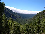
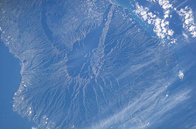
. It contains the enormous expanse of the Caldera de Taburiente, once believed to be a huge crater, but nowadays known to be a mountain arch with a curious crater shape, which dominates the northern part of the island. It was designated as a national park in 1954.
The caldera is about 10 km across, and in places the walls tower 2000 m over the caldera floor. The highest point is the Roque de los Muchachos
Roque de los Muchachos
Roque de los Muchachos is a rocky mound at the highest point on the island of La Palma in the Canary Islands, Spain...
on the northern wall, at 2423 m altitude, which can be reached by road. The telescopes of the Roque de los Muchachos Observatory
Roque de los Muchachos Observatory
Roque de los Muchachos Observatory is an astronomical observatory located in the municipality of Garafía on the island of La Palma in the Canary Islands...
are situated very close to the summit.
During the Spanish conquest of the Canary Islands in the 15th century, the caldera was the site of the last stand of the indigenous people of the archipelago
Archipelago
An archipelago , sometimes called an island group, is a chain or cluster of islands. The word archipelago is derived from the Greek ἄρχι- – arkhi- and πέλαγος – pélagos through the Italian arcipelago...
, the Guanches
Guanches
Guanches is the name given to the aboriginal Berber inhabitants of the Canary Islands. It is believed that they migrated to the archipelago sometime between 1000 BCE and 100 BCE or perhaps earlier...
. It proved impregnable to the invading Spaniards, and they only defeated the Guanches by luring their leader out on the pretext of holding talks.
The Cumbrecita is at a lower point in the south-eastern part of the caldera's rim, giving a good view into the Caldera. In the south-west the caldera opens to the sea, through a riverbed known as Barranco de las Augustias.
The Cumbre Nueva is a ridge that starts at the caldera and continues to the south.
The main flora of the national park comprises a large forest of Canary Island Pine
Canary Island Pine
Pinus canariensis, the Canary Island Pine, is a species in the genus Pinus, family Pinaceae, native and endemic to the outer Canary Islands in the Atlantic Ocean. It is a subtropical pine and does not tolerate low temperatures or hard frost, surviving temperatures down to about −6 to...
, with important population of the endangered
Endangered species
An endangered species is a population of organisms which is at risk of becoming extinct because it is either few in numbers, or threatened by changing environmental or predation parameters...
Canary Islands Juniper
Juniperus cedrus
Juniperus cedrus is a species of juniper, native to the western Canary Islands and Madeira , where it occurs at altitudes of 500-2400 m...
also present.
Geological origins

Shield volcano
A shield volcano is a type of volcano usually built almost entirely of fluid lava flows. They are named for their large size and low profile, resembling a warrior's shield. This is caused by the highly fluid lava they erupt, which travels farther than lava erupted from more explosive volcanoes...
about 20 km in diameter. The caldera was not formed by an explosion of that volcano however, but by erosion
Erosion
Erosion is when materials are removed from the surface and changed into something else. It only works by hydraulic actions and transport of solids in the natural environment, and leads to the deposition of these materials elsewhere...
starting from the volcano's original crater.
Name
The word "calderaCaldera
A caldera is a cauldron-like volcanic feature usually formed by the collapse of land following a volcanic eruption, such as the one at Yellowstone National Park in the US. They are sometimes confused with volcanic craters...
" means "cauldron
Cauldron
A cauldron or caldron is a large metal pot for cooking and/or boiling over an open fire, with a large mouth and frequently with an arc-shaped hanger.- Etymology :...
" in Spanish. Its use for very large volcanic craters originated with the Caldera de Taburiente.
Taburiente is not a Spanish word but derives from the Guanche language
Guanche language
Guanche is an extinct language that was spoken by the Guanches of the Canary Islands until the 16th or 17th century. It is only known today through a few sentences and individual words recorded by early travellers, supplemented by several placenames, as well as some words assimilated into the...
and means "plain, level".

