
Osney Lock
Encyclopedia
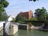
Osney Lock is a lock
on the River Thames
in Oxfordshire
, England. It is close to Oxford
where the village or island of Osney
is next to the river.
The first lock was built of stone by Daniel Harris
for the Thames Navigation Commission
in 1790.
Beside the lock to the southern side is Osney pool beside which is an Environment Agency
base for maintaining the river. The weir is upstream alongside the navigation channel in two parts and feeds the Osney pool.
To the south and southwest are Osney Mill Marina
and Osney Cemetery
. Oxford railway station
on the Botley Road
is close by to the northwest.
further west. The present stream was developed in mediaeval times by the monks of Osney Abbey
on the west side of the island then known as Osney, to serve as a millstream for Osney Mill
, in a manner similar to that at Abingdon
. There was an ancient weir, the property of the Abbey on the site, and a pound lock was first considered in 1787. The stream became the main navigation channel when the lock was built in 1790. Daniel Harris used prisoner labour from Oxford jail to give the cheapest quote for the work. The last rebuilding of the lock was in 1905.
on the A420 Botley Road
on the way west out of the centre of Oxford.
. On the eastern bank are built up parts of Oxford. After a stretch of allotments on the western bank and the backs of houses on the eastern bank there is the curious water crossroads - "Four Rivers". This provides a link to the Oxford Canal
via the Sheepwash Channel in one direction and there is Bulstake Stream
in the other direction. The river runs through willow banks until it reaches Fiddler's Island
. There used to be a weir and flash lock
here; now there is the rainbow shaped Medley Footbridge
crossing the main channel. On the other side of the island is Castle Mill Stream
, an old navigation channel that runs to the east closer to the centre of Oxford rejoining the Thames below the lock. On the eastern bank is the open ground of Port Meadow as far as Wolvercote
.
There are navigation transit markers
alongside Port Meadow upstream of Medley Boat station, to allow river users to check their speed. A powered boat should not pass between the markers in under one minute.
The Thames Path
crosses to the Oxford side at Osney Bridge and then crosses Fiddler's Island
and Medley Footbridge returning to the western bank to continue to Godstow Lock.
Lock (water transport)
A lock is a device for raising and lowering boats between stretches of water of different levels on river and canal waterways. The distinguishing feature of a lock is a fixed chamber in which the water level can be varied; whereas in a caisson lock, a boat lift, or on a canal inclined plane, it is...
on the River Thames
River Thames
The River Thames flows through southern England. It is the longest river entirely in England and the second longest in the United Kingdom. While it is best known because its lower reaches flow through central London, the river flows alongside several other towns and cities, including Oxford,...
in Oxfordshire
Oxfordshire
Oxfordshire is a county in the South East region of England, bordering on Warwickshire and Northamptonshire , Buckinghamshire , Berkshire , Wiltshire and Gloucestershire ....
, England. It is close to Oxford
Oxford
The city of Oxford is the county town of Oxfordshire, England. The city, made prominent by its medieval university, has a population of just under 165,000, with 153,900 living within the district boundary. It lies about 50 miles north-west of London. The rivers Cherwell and Thames run through...
where the village or island of Osney
Osney
Osney, Osney Island, or Osney Town is a riverside community in the west of the city of Oxford, England. It is located off the Botley Road, just west of the city's main railway station, on an island surrounded by the River Thames, known in Oxford as the Isis. Osney is part of the city council ward...
is next to the river.
The first lock was built of stone by Daniel Harris
Daniel Harris (Oxford)
Daniel Harris was a builder, prison governor, civil engineer and architect who lived and practised in Oxford.-Family:Harris's birthplace is obscure but he was born about 1761, as the entry in St-Peter-le-Bailey's register for his death in 1840 records his age as 79. He married Elizabeth Tomkins of...
for the Thames Navigation Commission
Thames Navigation Commission
The Thames Navigation Commission used to manage the River Thames in southern England. In particular, they were responsible for installing or renovating many of the locks on the river in the 18th and early 19th centuries.- History :...
in 1790.
Beside the lock to the southern side is Osney pool beside which is an Environment Agency
Environment Agency
The Environment Agency is a British non-departmental public body of the Department for Environment, Food and Rural Affairs and an Assembly Government Sponsored Body of the Welsh Assembly Government that serves England and Wales.-Purpose:...
base for maintaining the river. The weir is upstream alongside the navigation channel in two parts and feeds the Osney pool.
To the south and southwest are Osney Mill Marina
Osney Mill Marina
Osney Mill Marina is a private marina on a branch off the River Thames in Oxford, England. It is located south from the Botley Road down Mill Street and close to the site of Osney Abbey and Oxford railway station to the north....
and Osney Cemetery
Osney Cemetery
Osney Cemetery is a disused Church of England cemetery in Osney, west Oxford, England. It is in Mill Street south of Botley Road and near the site of Osney Abbey. It borders the Cherwell Valley Line railway a short distance south of Oxford railway station....
. Oxford railway station
Oxford railway station
Oxford railway station is a mainline railway station serving the city of Oxford, England. It is about west of the city centre, northwest of Frideswide Square and the eastern end of Botley Road, and on the line linking with . It is also on the line for trains between and Hereford via...
on the Botley Road
Botley Road
Botley Road is the main arterial road into Oxford, England from the west. It stretches between Botley, on the Oxford Ring Road to the west of the city, and Frideswide Square at the junction with Oxford railway station, close to central Oxford....
is close by to the northwest.
History
The main navigation channel was formerly on the branch of the river known as Bulstake StreamBulstake Stream
Bulstake Stream, also spelt Bullstake Stream, is a backwater of the River Thames at Oxford, England. It leaves the main stream of the Thames at a river junction known as Four Rivers, at the south west corner of Fiddler's Island. It immediately flows past Tumbling Bay, the site of a bathing place...
further west. The present stream was developed in mediaeval times by the monks of Osney Abbey
Osney Abbey
Osney Abbey or Oseney Abbey, later Osney Cathedral, was a house of Augustinian canons at Osney in Oxfordshire. The site is south of the modern Botley Road, down Mill Street by Osney Cemetery, next to the railway line just south of Oxford station. It was founded as a priory in 1129, becoming an...
on the west side of the island then known as Osney, to serve as a millstream for Osney Mill
Osney Mill
Osney Mill is a disused flour mill on a branch off the River Thames in Oxford, England. It is located south from the Botley Road down Mill Street.Close by is Osney Lock.To the east is Osney Cemetery and to the west is Osney Island....
, in a manner similar to that at Abingdon
Abingdon, Oxfordshire
Abingdon or archaically Abingdon-on-Thames is a market town and civil parish in Oxfordshire, England. It is the seat of the Vale of White Horse district. Previously the county town of Berkshire, Abingdon is one of several places that claim to be Britain's oldest continuously occupied town, with...
. There was an ancient weir, the property of the Abbey on the site, and a pound lock was first considered in 1787. The stream became the main navigation channel when the lock was built in 1790. Daniel Harris used prisoner labour from Oxford jail to give the cheapest quote for the work. The last rebuilding of the lock was in 1905.
Access to the lock
The lock can be reached a short way down the towpath from Osney BridgeOsney Bridge
Osney Bridge is a road bridge across the River Thames in Oxford, England, built in 1889 to replace a stone bridge which collapsed in 1885. It carries the Botley Road from Botley into Oxford...
on the A420 Botley Road
Botley Road
Botley Road is the main arterial road into Oxford, England from the west. It stretches between Botley, on the Oxford Ring Road to the west of the city, and Frideswide Square at the junction with Oxford railway station, close to central Oxford....
on the way west out of the centre of Oxford.
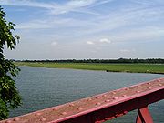
Reach above the lock
The river passes a former electricity generating station and is crossed by Osney Bridge near Oxford railway stationOxford railway station
Oxford railway station is a mainline railway station serving the city of Oxford, England. It is about west of the city centre, northwest of Frideswide Square and the eastern end of Botley Road, and on the line linking with . It is also on the line for trains between and Hereford via...
. On the eastern bank are built up parts of Oxford. After a stretch of allotments on the western bank and the backs of houses on the eastern bank there is the curious water crossroads - "Four Rivers". This provides a link to the Oxford Canal
Oxford Canal
The Oxford Canal is a narrow canal in central England linking Oxford with Coventry via Banbury and Rugby. It connects with the River Thames at Oxford, to the Grand Union Canal at the villages of Braunston and Napton-on-the-Hill, and to the Coventry Canal at Hawkesbury Junction in Bedworth just...
via the Sheepwash Channel in one direction and there is Bulstake Stream
Bulstake Stream
Bulstake Stream, also spelt Bullstake Stream, is a backwater of the River Thames at Oxford, England. It leaves the main stream of the Thames at a river junction known as Four Rivers, at the south west corner of Fiddler's Island. It immediately flows past Tumbling Bay, the site of a bathing place...
in the other direction. The river runs through willow banks until it reaches Fiddler's Island
Fiddler's Island
Fiddler's Island is an island in the River Thames at Oxford in England. It is situated south of Port Meadow on the reach above Osney Lock.The thin island sits between the Thames and Castle Mill Stream. On the south of the island a short stream known as the Sheepwash Channel divides the island from...
. There used to be a weir and flash lock
Flash lock
Early locks were designed with a single gate, known as a flash lock or staunch lock. The earliest European references to what were clearly flash locks were in Roman times....
here; now there is the rainbow shaped Medley Footbridge
Medley Footbridge
Medley Footbridge is a pedestrian bridge across the River Thames near the village of Binsey in Oxford, England. It is also known as Rainbow Bridge, although there is another bridge of that name in the University Parks in Oxford....
crossing the main channel. On the other side of the island is Castle Mill Stream
Castle Mill Stream
Castle Mill Stream is a backwater of the River Thames in the west of Oxford, England. It is 5.5 km long.-Course:The stream leaves the main course of the Thames at the south end of Port Meadow, immediately upstream of Medley Footbridge. It then flows under the Cherwell Valley railway line and turns...
, an old navigation channel that runs to the east closer to the centre of Oxford rejoining the Thames below the lock. On the eastern bank is the open ground of Port Meadow as far as Wolvercote
Wolvercote
Wolvercote is a village that is part of the City of Oxford, England, though still retaining its own identity. It is about northwest of the centre of Oxford, on the northern edge of Wolvercote Common, which is itself north of Port Meadow.-History:The village is listed in the Domesday Book as...
.
There are navigation transit markers
Navigation transit markers
Navigation Transit Markers are posts placed alongside a navigation to allow powered craft to check their speed. There are examples along the River Thames in England....
alongside Port Meadow upstream of Medley Boat station, to allow river users to check their speed. A powered boat should not pass between the markers in under one minute.
The Thames Path
Thames Path
The Thames Path is a National Trail, opened in 1996, following the length of the River Thames from its source near Kemble in Gloucestershire to the Thames Barrier at Charlton. It is about long....
crosses to the Oxford side at Osney Bridge and then crosses Fiddler's Island
Fiddler's Island
Fiddler's Island is an island in the River Thames at Oxford in England. It is situated south of Port Meadow on the reach above Osney Lock.The thin island sits between the Thames and Castle Mill Stream. On the south of the island a short stream known as the Sheepwash Channel divides the island from...
and Medley Footbridge returning to the western bank to continue to Godstow Lock.
 |
 |
External links
- Osney Lock at geograph.org.uk