

Worcester Street
Encyclopedia
Oxford
The city of Oxford is the county town of Oxfordshire, England. The city, made prominent by its medieval university, has a population of just under 165,000, with 153,900 living within the district boundary. It lies about 50 miles north-west of London. The rivers Cherwell and Thames run through...
, England
England
England is a country that is part of the United Kingdom. It shares land borders with Scotland to the north and Wales to the west; the Irish Sea is to the north west, the Celtic Sea to the south west, with the North Sea to the east and the English Channel to the south separating it from continental...
.
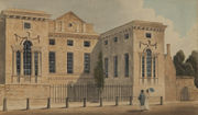
The street runs north-south in two sections that are separated for traffic. The northern section forms part of the A4144 road. It starts opposite the eponymous Worcester College
Worcester College, Oxford
Worcester College is one of the constituent colleges of the University of Oxford in England. The college was founded in the eighteenth century, but its predecessor on the same site had been an institution of learning since the late thirteenth century...
, one of the colleges of the University of Oxford
University of Oxford
The University of Oxford is a university located in Oxford, United Kingdom. It is the second-oldest surviving university in the world and the oldest in the English-speaking world. Although its exact date of foundation is unclear, there is evidence of teaching as far back as 1096...
, at the junction with Beaumont Street
Beaumont Street
Beaumont Street is a street in the centre of Oxford, England.The street was laid out from 1828 to 1837 with elegant terraced houses in the Regency style. Before that, it was the location of Beaumont Palace, now noted by a plaque near the junction with Walton Street...
and Walton Street
Walton Street
Walton Street is on the eastern edge of the Jericho district of central Oxford, England.- Overview :The street runs north from the western end of Beaumont Street and northern end of Worcester Street by the main entrance of Worcester College. Somerville College, one of the former women's colleges,...
. Worcester College occupies the entire western side of this portion of the street and Gloucester Green
Gloucester Green
Gloucester Green is a square in central Oxford, England, and the site of the city's bus station. It lies between George Street to the south and Beaumont Street to the north. To the west is Worcester Street and to the east is Gloucester Street....
, the location of Oxford's bus station, is to the east. The Refugee Studies Centre
Refugee Studies Centre
The Refugee Studies Centre was established in 1982, as part of the University of Oxford’s Department of International Development , in order to promote the understanding of the causes and consequences of forced migration and to improve the lives of some of the world’s most marginalised people...
, part of the University of Oxford’s Department of International Development, is also located here. The road continues round to the west as Hythe Bridge Street
Hythe Bridge Street
Hythe Bridge Street is in the west of central Oxford, England, forming part of the A4144 road.- Location :The street links Frideswide Square and then Botley Road to the east and Worcester Street at the western end leading north, at the junction with George Street...
, past the Oxford Canal
Oxford Canal
The Oxford Canal is a narrow canal in central England linking Oxford with Coventry via Banbury and Rugby. It connects with the River Thames at Oxford, to the Grand Union Canal at the villages of Braunston and Napton-on-the-Hill, and to the Coventry Canal at Hawkesbury Junction in Bedworth just...
towards Oxford railway station
Oxford railway station
Oxford railway station is a mainline railway station serving the city of Oxford, England. It is about west of the city centre, northwest of Frideswide Square and the eastern end of Botley Road, and on the line linking with . It is also on the line for trains between and Hereford via...
.
The southern section runs between George Street
George Street, Oxford
George Street is a street in central Oxford, England. It is a shopping street running east-west. Its eastern end meets Broad Street at a crossroads with Cornmarket Street to the south and Magdalen Street to the north...
and the junction of Park End Street
Park End Street
Park End Street is a street in central Oxford, England, to the west of the centre of the city, close to the railway station at its western end.-Location:...
and New Road
New Road, Oxford
New Road is a street in west central Oxford, England. It links Park End Street and Worcester Street to the west with Queen Street and Castle Street to the east. To the south is Oxford Castle and the former Oxford Prison, now a Malmaison hotel. To the north is Nuffield College, a graduate college of...
at the southern end. Worcester Street Car Park, formerly a wharf for the loading and unloading of goods near the end of the Oxford Canal, is to the west. The land was intended to be used for part of Nuffield College, but budgetary constraints meant that only the site to the east of Worcester Street was developed. The canal used to continue under Worcester Street Bridge to a coal wharf in New Road. To the east at the southern end of Worcester Street is Nuffield College, a graduate college of Oxford University, built between 1951 and 1960 on the site of the coal wharf.
The Oxford Job Centre is at 7 Worcester Street.