

Oregon Coast Trail
Encyclopedia
The Oregon Coast Trail is a long-distance hiking
route along the Pacific
coast of Oregon
in the United States
. It follows the coast of Oregon from the mouth of the Columbia River
to the California
border south of Brookings
.
The trail was created by Oregon Recreation Trails Advisory Council and managed by the Oregon Parks and Recreation Department
as part of the state park system of Oregon. The walking length of the trail varies depending on choice of passage across or around estuaries and rivers along the route. If a ferry is not arranged or available, an alternate route around the estuary must be taken; if traveling on foot, this means road walking. The length of the trail, using the Gmaps Pedometer tool to measure route mileage, is approximately 425 miles (684 km) if no ferries are used, though the official coastal guide gives a length of 382 miles (614.8 km). If no ferries are used, about 39% of the route is on the beach, 41% is on paved road, and 20% is on trail and dirt roads.
A chief feature of the trail are the public beaches created by 1967's Oregon Beach Bill
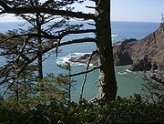
which formalized the public nature of the coastal beaches since the first such law was passed in 1913. Many of the locations, particularly on the southern portion, are remote and isolated. The Oregon coast is bordered by a temperate rainforest,much of which is now second or third growth.
The difficulty of the trail ranges from easy to moderate, with elevation changes of up to a few hundred feet.
 The northern trailhead is at the base of the south jetty of the Columbia River, approximately 4 miles (6 km) north of the campground of Fort Stevens State Park and about 13 miles (21 km) from the city of Astoria
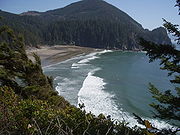
. The trail runs north-south along the entire Oregon Coast
, following the shore as closely as practical. For many portions of the route, it is beach walking, mostly on sand. In populated areas it often follows the nearest street to the shore. Many parts of the trail leave the beach and take an inland path, usually where land formations make the shoreline impassable, such as at Cape Kiwanda. Some of the rocky headlands are passable on foot at beach level only at low tide. Other headlands are traversed by state park or forest service trails well above the sea. In many other places, the road is the only feasible route, mostly U.S. Route 101
. The southern terminus of the trail is the unmarked Oregon/California border on a stretch of beach about 5 miles (8 km) south of Brookings, and about half a mile south of the Winchuck River
.
Besides headlands, there are numerous rivers and creeks which must be crossed. Most creeks are forded by wading, although sometimes the water can be waist deep even at low tide. At high tide, some are hazardous or impossible to cross and require a boat or a detour to a bridge. Rainfall during winter and early spring decreases the number of streams which are safely fordable.
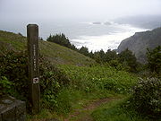
The trail is open to hikers, and in some places, to bicycle
s, and equestrians
. As portions of the route lead around headlands or cross river mouths that are only passable at low tide, carrying a current tide table
and relevant topographic information can be extremely helpful. Sometimes a hiker must choose between waiting for a lower tide or walking inland to avoid high water.
Many state campgrounds have areas dedicated for hikers and bicyclists at reduced prices. Beach camping is free but only where out of sight of residences and not adjacent to state parks. This limits camping on some areas of the trail to developed campgrounds. The State of Oregon has stated its intention to create more primitive and free camping areas.
The State of Oregon allows the public to use vehicles on some beaches. Dune buggies are used extensively in the Oregon Dunes National Recreation Area
, a 40 miles (64.4 km) stretch of beach from Florence to Coos Bay.
Several portions of the trail are pristine and secluded, such as the segment from Bandon
to Port Orford
, where several days of relative solitude and free camping exist.
Prevailing winds are from the northwest which makes the trail easier to hike from north to south. Route descriptions are also written assuming a north to south direction of travel.
Cities and towns of various sizes are located along Highway 101 every twenty to twenty-five miles permitting reprovisioning on a regular basis. Public transportation is extremely limited along the coast.
 Places found along the OCT from north to south.
Hiking
Hiking is an outdoor activity which consists of walking in natural environments, often in mountainous or other scenic terrain. People often hike on hiking trails. It is such a popular activity that there are numerous hiking organizations worldwide. The health benefits of different types of hiking...
route along the Pacific
Pacific Ocean
The Pacific Ocean is the largest of the Earth's oceanic divisions. It extends from the Arctic in the north to the Southern Ocean in the south, bounded by Asia and Australia in the west, and the Americas in the east.At 165.2 million square kilometres in area, this largest division of the World...
coast of Oregon
Oregon
Oregon is a state in the Pacific Northwest region of the United States. It is located on the Pacific coast, with Washington to the north, California to the south, Nevada on the southeast and Idaho to the east. The Columbia and Snake rivers delineate much of Oregon's northern and eastern...
in the United States
United States
The United States of America is a federal constitutional republic comprising fifty states and a federal district...
. It follows the coast of Oregon from the mouth of the Columbia River
Columbia River
The Columbia River is the largest river in the Pacific Northwest region of North America. The river rises in the Rocky Mountains of British Columbia, Canada, flows northwest and then south into the U.S. state of Washington, then turns west to form most of the border between Washington and the state...
to the California
California
California is a state located on the West Coast of the United States. It is by far the most populous U.S. state, and the third-largest by land area...
border south of Brookings
Brookings, Oregon
Brookings is a city in Curry County, Oregon, United States. It was named after John E. Brookings, president of the Brookings Lumber and Box Company, which founded the city in 1908. As of the 2010 census the population was 6,336. The total population of the Brookings area is over 13,000, which...
.
The trail was created by Oregon Recreation Trails Advisory Council and managed by the Oregon Parks and Recreation Department
Oregon Parks and Recreation Department
The Oregon Parks and Recreation Department , officially known as the State Parks and Recreation Department, is the government agency of the U.S. state of Oregon which operates its system of state parks...
as part of the state park system of Oregon. The walking length of the trail varies depending on choice of passage across or around estuaries and rivers along the route. If a ferry is not arranged or available, an alternate route around the estuary must be taken; if traveling on foot, this means road walking. The length of the trail, using the Gmaps Pedometer tool to measure route mileage, is approximately 425 miles (684 km) if no ferries are used, though the official coastal guide gives a length of 382 miles (614.8 km). If no ferries are used, about 39% of the route is on the beach, 41% is on paved road, and 20% is on trail and dirt roads.
A chief feature of the trail are the public beaches created by 1967's Oregon Beach Bill
Oregon Beach Bill
The Oregon Beach Bill was a piece of landmark legislation in the U.S. state of Oregon, passed by the 1967 session of the Oregon Legislature...
which formalized the public nature of the coastal beaches since the first such law was passed in 1913. Many of the locations, particularly on the southern portion, are remote and isolated. The Oregon coast is bordered by a temperate rainforest,much of which is now second or third growth.
The difficulty of the trail ranges from easy to moderate, with elevation changes of up to a few hundred feet.
Route
Astoria, Oregon
Astoria is the county seat of Clatsop County, Oregon, United States. Situated near the mouth of the Columbia River, the city was named after the American investor John Jacob Astor. His American Fur Company founded Fort Astoria at the site in 1811...
. The trail runs north-south along the entire Oregon Coast
Oregon Coast
The Oregon Coast is a region of the U.S. state of Oregon. It runs generally north-south along the Pacific Ocean, forming the western border of the state; the region is bounded to the east by the Oregon Coast Range. The Oregon Coast stretches approximately from the Columbia River in the north to...
, following the shore as closely as practical. For many portions of the route, it is beach walking, mostly on sand. In populated areas it often follows the nearest street to the shore. Many parts of the trail leave the beach and take an inland path, usually where land formations make the shoreline impassable, such as at Cape Kiwanda. Some of the rocky headlands are passable on foot at beach level only at low tide. Other headlands are traversed by state park or forest service trails well above the sea. In many other places, the road is the only feasible route, mostly U.S. Route 101
U.S. Route 101
U.S. Route 101, or U.S. Highway 101, is an important north–south U.S. highway that runs through the states of California, Oregon, and Washington, on the West Coast of the United States...
. The southern terminus of the trail is the unmarked Oregon/California border on a stretch of beach about 5 miles (8 km) south of Brookings, and about half a mile south of the Winchuck River
Winchuck River
The Winchuck River is a short coastal stream that runs through the Siskiyou National Forest to the Pacific Ocean in the U.S. state of Oregon. Flowing generally west from its origin near Elk Mountain, the river enters the sea at Crissey Field State Recreation Site, about north of the...
.
Besides headlands, there are numerous rivers and creeks which must be crossed. Most creeks are forded by wading, although sometimes the water can be waist deep even at low tide. At high tide, some are hazardous or impossible to cross and require a boat or a detour to a bridge. Rainfall during winter and early spring decreases the number of streams which are safely fordable.
Trail Walking Information
A dedicated guidebook for the OCT has not has been published. In 2009, the State of Oregon posted a set of downloadable maps with brief route descriptions. Local Oregon hiking guidebooks have good descriptions of portions of the route, particularly for the trail segments. Updated route guides are published on a discussion group. A recently published descriptive trail guide can be accessed in the Links at the bottom of the page. The Oregon Coast Trail is a described route and not a continuous trail. More than 150 miles (241.4 km) of the route is on pavement. The OCT is very poorly signed throughout its length, however it is difficult to become lost since the route is never more than a few miles from a paved road.The trail is open to hikers, and in some places, to bicycle
Bicycle
A bicycle, also known as a bike, pushbike or cycle, is a human-powered, pedal-driven, single-track vehicle, having two wheels attached to a frame, one behind the other. A person who rides a bicycle is called a cyclist, or bicyclist....
s, and equestrians
Equestrianism
Equestrianism more often known as riding, horseback riding or horse riding refers to the skill of riding, driving, or vaulting with horses...
. As portions of the route lead around headlands or cross river mouths that are only passable at low tide, carrying a current tide table
Tide table
A tide table, sometimes called a tide chart, is used for tidal prediction and shows the daily times and height of high water and low water for a particular location...
and relevant topographic information can be extremely helpful. Sometimes a hiker must choose between waiting for a lower tide or walking inland to avoid high water.
Many state campgrounds have areas dedicated for hikers and bicyclists at reduced prices. Beach camping is free but only where out of sight of residences and not adjacent to state parks. This limits camping on some areas of the trail to developed campgrounds. The State of Oregon has stated its intention to create more primitive and free camping areas.
The State of Oregon allows the public to use vehicles on some beaches. Dune buggies are used extensively in the Oregon Dunes National Recreation Area
Oregon Dunes National Recreation Area
The Oregon Dunes National Recreation Area is located on the Oregon Coast, stretching approximately 40 miles north from the Coos River in North Bend, to the Siuslaw River, in Florence. The NRA is part of Siuslaw National Forest and is administered by the United States Forest Service...
, a 40 miles (64.4 km) stretch of beach from Florence to Coos Bay.
Several portions of the trail are pristine and secluded, such as the segment from Bandon
Bandon, Oregon
- Economy :Like many communities on the Oregon coast, Bandon had significant fishing and timber industries, which were greatly diminished by the 1980s, though some remnants still exist. Bandon's current economy revolves around wood products, fishing, tourism, and agriculture...
to Port Orford
Port Orford, Oregon
Port Orford is a city in Curry County, Oregon, United States. It is on the southern Oregon Coast, at the northern end of what coastal Oregonians call the Banana Belt, because the weather from Port Orford south is noticeably warmer than the weather north of nearby Cape Blanco...
, where several days of relative solitude and free camping exist.
Prevailing winds are from the northwest which makes the trail easier to hike from north to south. Route descriptions are also written assuming a north to south direction of travel.
Cities and towns of various sizes are located along Highway 101 every twenty to twenty-five miles permitting reprovisioning on a regular basis. Public transportation is extremely limited along the coast.
Points of interest
- Fort Stevens State Park
- GearhartGearhart, OregonGearhart is a city in Clatsop County, Oregon, United States. The population was 995 at the 2000 census. The 2007 estimate is 1,185 residents.- Geography :...
, at the mouth of the Necanicum RiverNecanicum RiverThe Necanicum River is river on the Pacific coast of northwest Oregon in the United States, approximately long. It drains a timber-producing area of the Northern Oregon Coast Range northwest of Portland... - SeasideSeaside, OregonSeaside is a city in Clatsop County, Oregon, United States. The name Seaside is derived from Seaside House, a historic summer resort built in the 1870s by railroad magnate Ben Holladay. The city's population was 6,457 at the 2010 census.-History:...
- Tillamook HeadTillamook HeadTillamook Head is a high promontory on the Pacific coast of northwest Oregon in the United States. It is located in west-central Clatsop County, approximately 5 mi southwest of Seaside. The promontory forms a steep rocky bluff on the ocean, approximately 1,200 ft high, forested with...
- Ecola State Park
- Cannon BeachCannon Beach, OregonCannon Beach is a city in Clatsop County, Oregon, United States. The population was 1,588 as of the 2000 census. The 2007 estimate is 1,680 residents.- History :...
- Oswald West State ParkOswald West State ParkOswald West State Park is part of the state park system of the U.S. state of Oregon. It is located about south of the city of Cannon Beach, on the Pacific Ocean. Oswald West has unique walk-in access, with wheelbarrows provided by the parks system for transporting gear from the parking area to the...
- ManzanitaManzanita, OregonManzanita is a coastal city in Tillamook County, Oregon, United States. It is located on U.S. Route 101 about 25 miles south of Seaside and 25 miles north of Tillamook. The population was 564 as of the 2000 census.-History:...
- NehalemNehalem, OregonNehalem is a city in Tillamook County, Oregon, United States. Incorporated in 1889, the city is located on the Nehalem River at Nehalem Bay of the Pacific Ocean. It is bisected by U.S. Route 101. The population was 203 at the 2000 census.-History:...
and Nehalem Bay State ParkNehalem Bay State ParkNehalem Bay State Park is a state park in the United States located on the Oregon Coast, near the communities of Nehalem and Manzanita on the Nehalem Spit, a sand spit west of Nehalem Bay.... - GaribaldiGaribaldi, OregonGaribaldi is a city in Tillamook County, Oregon, United States. The population was 895 in 2007 according to Portland State University.-History:...
- Tillamook BayTillamook BayTillamook Bay is a small inlet of the Pacific Ocean, approximately 6 mi long and 2 mi wide, on the northwest coast of the U.S. state of Oregon...
- TillamookTillamook, OregonThe city of Tillamook is the county seat of Tillamook County, Oregon, United States. The city is located on the southeast end of Tillamook Bay on the Pacific Ocean. The population was 4,352 at the 2000 census...
- Cape Meares State Park
- OceansideOceanside, OregonOceanside is a census-designated place and unincorporated community in Tillamook County, Oregon, United States. The population was 326 at the 2000 census.-Geography:...
- NetartsNetarts, OregonNetarts is an unincorporated community in Tillamook County, Oregon, United States; it is a census-designated place . The population was 744 at the 2000 census.-Geography:...
- Cape LookoutCape Lookout (Oregon)Cape Lookout is a sharp rocky promontory along the Pacific Ocean coast of northwestern Oregon in the United States. It is located in southwestern Tillamook County, approximately 10 mi southwest of Tillamook, just south of Netarts Bay...
and Cape Lookout State ParkCape Lookout State ParkCape Lookout State Park is a state park on Cape Lookout in the U.S. state of Oregon. It is located in Tillamook County, south of the city of Tillamook, on a sand spit between Netarts Bay and the Pacific Ocean.... - NeskowinNeskowin, OregonNeskowin is an unincorporated community in Tillamook County, Oregon, United States, near where Slab Creek empties into the Pacific Ocean. For statistical purposes, the United States Census Bureau has defined Neskowin as a census-designated place . The census definition of the area may not...
- Lincoln CityLincoln City, OregonLincoln City is a city in Lincoln County, Oregon, United States. It is named after the county. The population was 7,930 at the 2010 census.- History :...
- Depoe BayDepoe Bay, OregonDepoe Bay is a city in Lincoln County, Oregon, United States, located on U.S. Route 101 next to the Pacific Ocean. The population was 1,174 at the 2000 census, with an unofficial estimated population of 1,355 in 2007...
- Devils Punch Bowl State Natural AreaDevils Punch Bowl State Natural AreaDevils Punch Bowl State Natural Area is a state day use park on the central Oregon Coast in the United States. It is centered on a large bowl naturally carved in a rock headland which is partially open to the Pacific Ocean. Waves enter the bowl and often violently churn, swirl, and foam...
- Beverly Beach State ParkBeverly Beach State ParkBeverly Beach State Park is a state park in the U.S. state of Oregon located north of Newport. It is a full R.V. hookup camping area with showers, bathrooms, beach access, and a meeting hall where evening interpretive programs take place. The park also has tent areas, as well as yurts for rent....
- NewportNewport, OregonNewport is a city in Lincoln County, Oregon, United States. It was incorporated in 1882, though the name dates back to the establishment of a post office in 1868...
- South Beach State ParkSouth Beach State ParkSouth Beach State Park is a state park in the U.S. state of Oregon, administered by the Oregon Parks and Recreation Department....
- Ona Beach State ParkOna Beach State ParkOna Beach State Park is a state park in Lincoln County, Oregon United States, administered by the Oregon Parks and Recreation Department....
- Seal Rock State Recreation SiteSeal Rock State Recreation SiteSeal Rock State Recreation Site is a state park in the U.S. state of Oregon, administered by the Oregon Parks and Recreation Department....
- WaldportWaldport, OregonWaldport is a city in Lincoln County, Oregon, United States. The population was 2,050 at the 2000 census. The city is located on the Alsea River and Alsea Bay, south of Newport and north of Yachats.-Geography:...
- YachatsYachats, OregonYachats is a small coastal city in Lincoln County, Oregon, United States. According to Oregon Geographic Names, the name comes from the Siletz language, and means "dark water at the foot of the mountain". There is a range of differing etymologies, however. William Bright says the name comes from...
- Neptune State Scenic ViewpointNeptune State Scenic ViewpointNeptune State Scenic Viewpoint is a state park in the U.S. state of Oregon, administered by the Oregon Parks and Recreation Department....
- Carl G. Washburne Memorial State ParkCarl G. Washburne Memorial State ParkCarl G. Washburne Memorial State Park is a state park in the U.S. state of Oregon, administered by the Oregon Parks and Recreation Department....
- Heceta Head LightHeceta Head LightHeceta Head Light is a lighthouse located on the Oregon Coast north of Florence, Oregon and south of Yachats, Oregon, United States. It is located at Heceta Head Lighthouse State Scenic Viewpoint midway up a 205-foot tall headland...
- Jessie M. Honeyman Memorial State ParkJessie M. Honeyman Memorial State ParkJessie M. Honeyman Memorial State Park, also known simply as Honeyman State Park, is located in Lane County, three miles south of the city of Florence, on Highway 101. The Oregon Dunes National Recreation Area adjoins the park to the west...
- Oregon Dunes National Recreation AreaOregon Dunes National Recreation AreaThe Oregon Dunes National Recreation Area is located on the Oregon Coast, stretching approximately 40 miles north from the Coos River in North Bend, to the Siuslaw River, in Florence. The NRA is part of Siuslaw National Forest and is administered by the United States Forest Service...
- ReedsportReedsport, OregonReedsport is a city in Douglas County, Oregon, United States. As of the 2010 census, the population was 4,154.- History :Reedsport was established on the estuary of the Umpqua River on January 7, 1852. It was named for a local settler, Alfred W. Reed, who founded the city in 1912...
- Umpqua Lighthouse State Park
- Coos BayCoos Bay, OregonCoos Bay is a city located in Coos County, Oregon, United States, where the Coos River enters Coos Bay on the Pacific Ocean. The city borders the city of North Bend, and together they are often referred to as one entity called either Coos Bay-North Bend or the Bay Area...
- Bullards Beach State ParkBullards Beach State ParkBullards Beach State Park is a state park in the U.S. state of Oregon, administered by the Oregon Parks and Recreation Department....
- BLM primitive campground, at the New River ACEC
- Boice Cope Park, a Curry CountyCurry County, OregonCurry County is a county located in the U.S. state of Oregon. In 2010, its population was 22,364. The county is named for George Law Curry, a governor of the Oregon Territory. The seat of the county is Gold Beach.-Economy:...
campground at Floras Lake - Cape BlancoCape Blanco (Oregon)Cape Blanco is a prominent headland on the Pacific Ocean coast of southwestern Oregon in the United States, forming the westernmost point in the state. It contests with Cape Alava in Washington for the title of westernmost point in the contiguous United States...
and Cape Blanco State Park - Humbug Mountain State ParkHumbug Mountain State ParkHumbug Mountain State Park is a state park located on the Oregon coast. It is administered by the Oregon Parks and Recreation Department. The park can be accessed via the US Route 101, south of Port Orford, and north of Gold Beach....
- Gold BeachGold Beach, OregonGold Beach is a city in and the county seat of Curry County, Oregon, United States, on the Oregon Coast. The population was 1,897 at the 2000 census.-History:...
- Samuel Boardman State Park
- Harris Beach State ParkHarris Beach State ParkHarris Beach State Park is an Oregon State Park located on US Highway 101, north of Brookings. The day-use area offers a restroom and picnic area with tables, and the campground has RV sites, yurts and tent sites available year-round....
- BrookingsBrookings, OregonBrookings is a city in Curry County, Oregon, United States. It was named after John E. Brookings, president of the Brookings Lumber and Box Company, which founded the city in 1908. As of the 2010 census the population was 6,336. The total population of the Brookings area is over 13,000, which...
External links
- OCT Trail logs and other information
- Oregon tide tables for current year published by Oregon State Parks
- Henderson OCT page Descriptive trail guide.