
Devils Punch Bowl State Natural Area
Encyclopedia
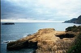
Devils Punch Bowl State Natural Area is a state day use park on the central Oregon Coast
in the United States
. It is centered on a large bowl naturally carved in a rock headland which is partially open to the Pacific Ocean
. Waves enter the bowl and often violently churn, swirl, and foam. Outside the bowl, ocean conditions are attractive to surfers near a large offshore rock pinnacle named Gull Rock (located about a half mile WNW of Devils Punch Bowl), which funnels and concentrates waves easily seen from the park. There are at least seventeen large rocks, part of Oregon Islands National Wildlife Refuge
, which provide interesting wave viewing, and attract and provide a home for wildlife.
Devils Punch Bowl is located about 8 miles (12.9 km) north of Newport, Oregon
in the community of Otter Rock
, and about one-quarter mile west of U.S. Route 101
. The park encompasses 5.34 acres (2 ha), which includes picnic grounds. There is a trail for access to the beach, and tide pool
s.
The bowl is thought to have been created when two caves carved by the ocean collapsed.
Whales migrate past the park, in season, and the park, which projects into the Pacific, provides panoramic views of the ocean and good whale watching.
installed a fresh water system, sanitary works, picnic tables, stoves, trails, and safety fences.
Park attendance in 1963 totaled 228,528 visitors. June through October is the park's busiest season.
Oregon Coast
The Oregon Coast is a region of the U.S. state of Oregon. It runs generally north-south along the Pacific Ocean, forming the western border of the state; the region is bounded to the east by the Oregon Coast Range. The Oregon Coast stretches approximately from the Columbia River in the north to...
in the United States
United States
The United States of America is a federal constitutional republic comprising fifty states and a federal district...
. It is centered on a large bowl naturally carved in a rock headland which is partially open to the Pacific Ocean
Pacific Ocean
The Pacific Ocean is the largest of the Earth's oceanic divisions. It extends from the Arctic in the north to the Southern Ocean in the south, bounded by Asia and Australia in the west, and the Americas in the east.At 165.2 million square kilometres in area, this largest division of the World...
. Waves enter the bowl and often violently churn, swirl, and foam. Outside the bowl, ocean conditions are attractive to surfers near a large offshore rock pinnacle named Gull Rock (located about a half mile WNW of Devils Punch Bowl), which funnels and concentrates waves easily seen from the park. There are at least seventeen large rocks, part of Oregon Islands National Wildlife Refuge
Oregon Islands National Wildlife Refuge
Oregon Islands National Wildlife Refuge is a U.S. National Wildlife Refuge off the southwestern Oregon Coast. It is one of six National Wildlife Refuges comprising the Oregon Coast National Wildlife Refuge Complex...
, which provide interesting wave viewing, and attract and provide a home for wildlife.
Devils Punch Bowl is located about 8 miles (12.9 km) north of Newport, Oregon
Newport, Oregon
Newport is a city in Lincoln County, Oregon, United States. It was incorporated in 1882, though the name dates back to the establishment of a post office in 1868...
in the community of Otter Rock
Otter Rock, Oregon
Otter Rock is an unincorporated community in Lincoln County, Oregon, United States. It is located on U.S. Route 101 on the Oregon Coast.Otter Rock post office was established in 1913, and takes its name from a rock located about a half mile offshore and three and a quarter miles north of Yaquina Head...
, and about one-quarter mile west of U.S. Route 101
U.S. Route 101
U.S. Route 101, or U.S. Highway 101, is an important north–south U.S. highway that runs through the states of California, Oregon, and Washington, on the West Coast of the United States...
. The park encompasses 5.34 acres (2 ha), which includes picnic grounds. There is a trail for access to the beach, and tide pool
Tide pool
Tide pools are rocky pools by oceans that are filled with seawater. Many of these pools exist as separate entities only at low tide.Tide pools are habitats of uniquely adaptable animals that have engaged the special attention of naturalists and marine biologists, as well as philosophical...
s.
The bowl is thought to have been created when two caves carved by the ocean collapsed.
Whales migrate past the park, in season, and the park, which projects into the Pacific, provides panoramic views of the ocean and good whale watching.
History
The park was acquired in at least three parcels between 1929 and 1952. The Civilian Conservation CorpsCivilian Conservation Corps
The Civilian Conservation Corps was a public work relief program that operated from 1933 to 1942 in the United States for unemployed, unmarried men from relief families, ages 18–25. A part of the New Deal of President Franklin D...
installed a fresh water system, sanitary works, picnic tables, stoves, trails, and safety fences.
Park attendance in 1963 totaled 228,528 visitors. June through October is the park's busiest season.